We found 109182 price guide item(s) matching your search

Refine your search

Year

Filter by Price Range
  • List
  • Grid
  • 109182 item(s)
    /page

Lot 162

Abraham Orteluis - a map of England and Wales, hand coloured, titled 'Anglise Regni Filo Rentissimi Nora Descriptio Artcore Humfredo Hivyd Den Byglense', dated 1573, (or later), 39 x 47cm, mounted in glazed frame, along with a small Edward Cherry signed engraving and a print after John Piper

Lot 426

The Howard Vincent map of the British Empire, twenty first edition circa 1924, limited edition no 657/7500, 56cm x 64cm, glazed maple frame, a Chinese embroidered pictures depicting various birds and wildfowl around a prunus tree, 35cm x 58cm, glazed frame, and a contemporary oval gilt framed wall mirror, with bevelled plateLocation: A4B

Lot 142

J. BLAEUMAP OF SOUTHERLANDIA, hand coloured, with text verso, 39cm x 53cm, framed and glazed

Lot 143

TIMOTHY PONTSKIA VEL SKIANA,hand coloured map of the Isle of Skye, 42cm x 53cm and another - Levinia, The Province of Lennox, both framed and glazed (2)

Lot 87

A GENERALL MAP OF THE KINGDOME OF TARTARIA..., AFTER SANSON (N.),circa 1670, later illuminated in colours, 13.5cm x 44cm, framed and under glass, along with a General Mapp ofg the East-Indies..., after Sanson (2)

Lot 88

COMIC MAP OF EUROPE, LATE 19TH CENTURY CARICATURE MAP,based upon Paul Hadol's popular prototype of 1870, hand-coloured lithograph, approx. 28cm x 42cm, mounted, framed and under glassThe map itself appears generally good. Foxing above the OF, and same position to bottom edge. Some other minor areas to edge, and yellowing of paper but generally good for age. Frame worn and would benefit from reframing. Additional images now available.

Lot 102

Desnos (Louis Charles & Le Rouge George Louis). Nouvel Atlas D'Angleterre. Divisé en ses 52 Comtéa avec toutes les Routes Levées Topographiquement par ordre se S M Britannique et les Plans des Villes et Ports de ce Royaume, Paris, 1767, decorative title page with library blindstamp and additional ink library stamp to verso, twelve double page engraved regional maps with contemporary outline colouring which if conjoined create a map of England & Wales, engraved title page, 'Itineraraire de Toutes Les Routes de L'Angleterre...., par Senex en 101 cartes, Paris, dated 1757, title repeated in English, introduction and list of towns, the list of towns appear to have been re-margined, 101 uncoloured engraved strip road maps all with blank versos, bound with Recueil des Villes Ports D'Angleterre Tiré des Grands plans de Rocque et du Portuland de L'Angleterre de Sr. Belin, Paris, 1766, decorative title, double-page table of explanation for an uncoloured double page engraved map of London, an engraved map of the 'Bouche de la Tamise' and sixteen engraved single sheet plans of British and Irish towns, later endpapers, bookplate of The Free Library of Philadelphia, Map Division, modern half morocco, 4toQTY: (1)NOTE:Chubb. Number 143.

Lot 106

Hasted (Edward). The History and Topographical Survey of the County of Kent, 4 volumes, 1st edition, Canterbury: Printed for the Author, by Simmons and Kirkby, 1778-99, large engraved folding map of Kent, 98 engraved maps, plans and plates (of which 38 double-page & 12 folding), occasional light toning and minor spotting, armorial bookplate of Gerald Gascoigne Lynde to upper pastedowns, 19th century dark green half morocco, terracotta red labels to spines, extremities slightly rubbed, folio, contained together in wooden slipcase with divisions for each volumeQTY: (4)NOTE:Upcott I, p.358-368.

Lot 110

Ireland (William Henry), England's Topographer, or a new and Complete History of the County of Kent; From the earliest records to the present time, including every modern improvement. Embellished with a series of views from Original Drawings by Geo. Shepherd, H. Gastineau, &c., 4 volumes, London: George Virtue, 1828-30, engraved title to volume 1, folding engraved map, 124 engraved plates, some spotting and browning, contemporary calf, elaborate gilt decorated spines with contrasting morocco labels, 8vo, together with:Dearn (Thomas Downes Wilmot), An historical topographical and descriptive account of the Weald of Kent, Cranbrook: S. Reader, 1814, eight uncoloured aquatint plates (including frontispiece), engraved map, edges untrimmed, contemporary marbled calf, rebacked and corners repaired, 8vo (Abbey Scenery 175),Dunkin (John), The History and Antiquities of Dartford, with topographical notices of the neighbourhood, London: John Russell Smith, 1844, engraved portrait frontispiece, chromolithograph title, few lithograph and engraved plates (one hand-coloured), modern calf gilt, 8voQTY: (6)

Lot 112

Kitchin (Thomas). Kitchin's Post-Chaise Companion through England and Wales containing all the Ancient and New Additional Roads with every Topographical Detail relating thereto..., John Bowles, Carington Bowles and Robert Sayer, 1767, title page with slight staining, index of cities and towns, table of crossroads and an uncoloured engraved general map of England & Wales, 103 (complete) uncoloured engraved strip road maps on 51 sheets, printed, back to back, slight offsetting throughout, later limp calf, oblong 8voQTY: (1)NOTE:Chubb. CXLI. A re-issue of John Senex's 'Actual Survey of all the Principal Roads of England and Wales..,' first published in 1719.

Lot 113

Lambarde (William). A Perambulation of Kent: conteining the description, hystorie, and customes of that shyre. Collected and written (for the most part) in the yeare. 1570. 1st edition, Imprinted at London [By Henrie Middleton] for Ralphe Newberie, 1576, title within decorative typographic border and with early 19th century initial dated 1831, hand-coloured engraved map laid down to blank verso of final preliminary leaf ¶¶iv, black letter text, few woodcut decorative initials, erratic & errors in pagination, occasional early marginallia to few leaves, final leaf and with lower blank half torn away and repaired, some light dust-soiling and few minor marks, 20th century half calf, 4toQTY: (1)NOTE:ESTC S108236; STC 15175. In this example the colophon includes Middleton's name, however a variant published in the same year omitted Middleton’s name from the colophon. The setting was otherwise the same.

Lot 114

Lambarde (William). A perambulation of Kent: conteining the description, hystorie, and customes of that shyre. Written in the yeere 1570 by William Lambarde of Lincolnes Inne Gent: first published in the yeere 1576. and now increased and altered after the authors owne last copie, 2nd edition, London: Edm. Bollifant, 1596, [10], 588, [6] p., title within elaborate typographic border and with early ownership signature P. Barrett and dated December 19 1656, folding woodcut map of the Beacons in Kent and woodcut Heptarchy map (slightly close-trimmed to ruled border), woodcut initals, black letter text, 19th century bookplate of William Deedes to upper pastedown, 20th century half calf, preserving earlier maroon morocco title label to spine, small 4to in 8sQTY: (1)NOTE:STC 15176; ESTC S108239.

Lot 115

* Laurie (Robert & Whittle James, publishers). Laurie & Whittle's New Traveller's Companion Exhibiting a Complete and Correct Survey of all the Direct and Principal Cross Roads in England Wales and Scotland; as far North as Edinburgh and Glasgow...., 6th. edition, 1812, title page, advertisement, index and table of explanation all present, general map of England & Wales and twenty-five (complete) engraved road maps, all with original hand colouring, some offsetting and slight staining, marbled endpapers, hinges professionally strengthened with marbled paper, bookplate of Sir John Cox Hippisley Bart. contemporary limp morocco with a skilful re-back with gilt title and date to the spine, large 8voQTY: (1)NOTE:There is some variation in the dates at the base of the maps, with the map of England & Wales dated 1808, and the strip road maps dated 1806 except for the last map (of Scotland) dated 1809.

Lot 116

Leigh (Samuel). Leigh's New Atlas of England & Wales [1820], frontispiece of a table of the price of posting, decorative title, 55 uncoloured engraved maps by Sidney Hall, a general folding map of England & Wales with contemporary outline colouring bound at rear, contemporary calf gilt, re-backed but retaining the original spine, 12mo, together with Mogg (Edward). Mogg's Pocket itinerary of the Direct and Cross Roads of England and Wales with Part of the Roads of Scotland, circa 1833, decorative title, an engraved folding map of England & Wales and publisher's advertisement bound at rear, contemporary calf gilt, re-backed but retaining the original spine, 12mo, with Osbourne (E. C. & W. publisher). Osborne's Guide to the Grand Junction, or Birmingham, Liverpool and Manchester Railway..., 1838, decorative title and a frontispiece of a folding engraved map, near contemporary ownership signatures to the front endpaper, contemporary blind-stamped cloth gilt, small 8vo, with another copy similar, plus Mogg (Edward). Paterson's Roads; Being an Entirely original and Accurate Description of all the Direct and principal Cross Roads in England and Wales..., 16th edition, 1822, frontispiece of a folding engraved map of England & Wales, eight additional regional folding maps, bound at the rear, later endpapers, modern half morocco gilt, 8vo, with another copy similar of the 18th edition (1826), and Grose (Francis). The Antiquities of England and Wales..., volume 7 (only), 1797, engraved frontispiece, decorative title, uncoloured engraved folding map of England & Wales, eleven engraved Welsh county maps, all with sparse contemporary outline colouring, numerous engraved topographical views, marbled endpapers, upper board near detached, contemporary diced calf gilt, 8vo, with Virtue & Co. (publishers). The National Gazetteer..., 3 volumes, circa 1870, additional decorative half-title, 65 double-page colour lithographic maps, contemporary half morocco gilt, re-backed, rubbed and worn, 8vo, and Bartholomew (John). The Survey Atlas of England & Wales..., 2nd edition, 1939, title page with four old ink library stamps, 81 colour lithographic double-page maps, contemporary quarter morocco gilt, worn at extremities, folioQTY: (11)

Lot 117

Lewis (William, publisher). Lewis's New Travellers Guide, or a Pocket Edition of the English Counties, Containing all the Direct & Cross Roads in England & Wales..., 1819 (dated on preface), decorative title of a coach with postillions under a calligraphic title, preface, contents, list of Mail Coaches, Rates of Postage and a table for the charges for a pair of Post-Horses, 42 (complete as list) engraved maps with contemporary hand colouring, including 1 folding (Yorkshire), each with a page of explanatory text, slight staining throughout, later endpapers, modern cloth with paper title label to spine, 12mo, together with Hall (Sidney). A Travelling County Atlas with all the Railroads..., Chapman & Hall, circa 1854, printed title, 46 engraved maps (comprising 42 double-page, and 4 folding, including Ireland, Scotland, Wales, and Yorkshire), all with contemporary outline colouring, later endpapers, contemporary 'envelope' style black morocco binding with gilt title to the upper cover, 8vo, with Capper (Benjamin Pitts). A Topographical Dictionary of the United Kingdom..., printed for Richard Phillips, 1st edition, 1808, frontispiece of an uncoloured engraved folding map of the British Isles, printed title, both with some staining, 45 uncoloured engraved maps, later endpapers, modern half morocco gilt, 8voQTY: (3)

Lot 121

Skelton (Joseph). Skelton's Engraved Illustrations of the Principal Antiquities of Oxfordshire, from original drawings by F. Mackenzie, large paper copy, Oxford: J Skelton, 1823, engraved frontispiece, engraved title, map and 49 plates (tissue-guards to each), further engraved illustrations to text, subscriber's list, near-contemporary ownership inscription 'Job Lansley's book Hampstead Norris Berks 1843' to dedication leaf, armorial bookplate of Oliver Brett to front pastedown, broad gilt turn-ins, spotting, contemporary calf, green morocco title label, boards with gilt foliate borders, spine separated into 6 compartments by raised bands finished in gilt, compartments with elaborate gilt foliate devices, some wear, folioQTY: (1)

Lot 124

Tombleson (William and Fearnside, William Gray). [Eighty Picturesque Views on the Thames and Medway, Black and Armstrong], circa 1850, lacking title but retaining the additional decorative engraved title, dedication and preface, 79 uncoloured engraved plates (complete), with later tissue guards, folding engraved pictorial linear map on two sheets conjoined, bound at rear, some spotting to the map, occasional spotting throughout, near contemporary ownership signature to the front endpaper, all edges gilt, contemporary half morocco gilt worn and rubbed at extremities, 4toQTY: (1)

Lot 125

Virtue (George). The Picturesque Beauties of Great Britain: illustrated by topographical, historical, and critical notices ... Kent, London: George Virtue, [1829], engraved frontispiece, additional engraved title, folding engraved county map, 126 engraved views of 128 on 63 plates (of 64), some damp staining and spotting, contemporary half calf, gilt decorated spine, 4to, together with:Stanfield (Clarkson), Stanfield's Coast Scenery. A series of views in the British Channel, London: Smith, Elder & Co., 1836, engraved frontispiece, additional engraved title, 38 engraved plates, all edges gilt, contemporary gilt decorated morocco, 8vo,Newman (John & Co., publishers), Illustrations of British Scenery, London: John Newman & Co., 1881, lithograph decorative title (detached), 100 engraved vignette views on 50 plates, occasional spotting, all edges gilt, front free endpaper and following blank torn to lower outer corner, original gilt-blocked cloth, extremities worn, 4to, plus Finden's Views of the Ports, Harbours & Watering Places of Great Britain, continued by W.H. Bartlett, 2 volumes, [1842], numerous engraved plates, some spotting and marginal browning etc., all edges gilt, contemporary gilt decorated calf, joints worn, volume 2 front board detached, 4toQTY: (5)

Lot 143

Africa. Speed (John), Africae described, the manners of their habits and buildings newly done into English by J. S. G. Humble [1627], hand coloured engraved 'carte-a-figure' map with ten costumed figures to the vertical margins and eight oval vignettes of principal cities along the upper horizontal margin, central fold partially strengthened and repaired on verso, slight marginal staining and soiling, one marginal closed tear, 390 x 505 mm, English text on verso QTY: (1)

Lot 144

Americas. 16th - 18th century, engraved maps, including Moll (Herman), A New Map of North America According to the Newest Observations, circa 1725, hand-coloured engraved map, insular California, slight spotting, 180 x 255 mm, mounted, together with Ruscelli (Girolamo). Tierra Nova, circa 1574, uncoloured engraved map after an earlier example by Giacomo Gastaldi, 185 x 255 mm, Latin text on verso, mountedQTY: (2)

Lot 145

Arabian Gulf. Bruce (James), To The King. This Map, containing a Chart of the Arabian Gulf with its Egyptian, Ethiopian and Arabian Coasts, from Suez to Bab el Mandeb..., circa 1805, hand-coloured engraved map, calligraphic cartouche, inset maps of the Harbour of Masuah, The Harbour of Sebt, the Harbour of Ibraim and the Harbour of Babac, old folds, 635 x 505 mm, mounted, together with To the Right Revd. John Lord Bishop of Carlisle, This Map shewing the Tract of Solomon's Fleet in their three year Voyage from the Elanitic Gulf to Ophir and Tarshish..., circa 1800, hand-coloured engraved map, calligraphic cartouche, old folds, 680 x 315 mm, mounted, with Munster (Sebastian). Franckfurt an der Oder Anno Dni. Basel, circa 1548, uncoloured double-page woodblock map, 265 x 310 mm, Latin text below and on verso, mounted, with another similar (but single page) of Riga, image size 100 x 160 mm, mounted, plus Mercator (Gerard & Hondius J.). China, circa 1636, hand-coloured engraved map, 145 x 190 mm, English text on verso, mounted, and an unattributed map of the Holy Land, Sortie Des Enfans D'Israel Hors D'Egypte leur passage par Mer Rouge Le Voyage qu'ils sirent pendant 40 annees dans les Deserts, et leur entree au pais de Canaan, circa 1700, a hand-coloured engraved map showing the Exodus from Israel of the Children of Egypt., some creasing, repaired closed tears, old folds with some repaired on verso, small areas of loss repaired on verso, 410 x 540 mm, mountedQTY: (6)

Lot 146

* Barbados. Ogilby (John), Novissima et Acuratissima Barbados. Descriptio per Johannem Ogilvium. Cosmographum Regium, circa 1672, hand-coloured engraved map, elaborate strapwork cartouche and mileage scale, large margins, slight spotting, one repaired hole in the margin but not affecting the printed image, 295 x 360 mm, framed and glazedQTY: (1)

Lot 15

Clapperton (Hugh). Journal of a Second Expedition into the Interior of Africa, from the Bight of Benin to Soccatoo, 1st edition, London: John Murray, 1829, half title, mezzotint portrait frontispiece, folding map (with short closed tear), single page engraved plan, occasional light spotting, a few small ink stamps of the Bibliotheca Edinensis, contemporary previous owner signature, 1829 to front pastedown, original cloth-backed boards, paper label to spine, spine faded and bumped at head, some light edge wear, 4to QTY: (1)

Lot 150

British Isles. Boisseau (Jean). Carte generalle de la Grande Bretagne jadis Albion et du Royaume d'Irlande ou Hybernie avec les Isles circonuoisines despandantes des dits Royaumes, Paris, 1644, hand-coloured engraved map, inset map of the Orkney islands, two blocks of descriptive text, 380 x 510 mm, together with Halma (Francois). Antiquorum Britanniae Episcopatum Geographica Description, Amsterdam, circa 1705, hand-coloured engraved map, large decorative allegorical cartouche, 375 x 515 mmQTY: (2)NOTE:The first described item. R. W. Shirley, Early Printed Map of the British Isles, no. 535. An uncommon map, separately published and derived from the outline used by Johannes Blaeu, but with very different decorative features and cartouche. The second item, R. W. Shirley, Printed Map of the British Isles, 1650 - 1750, Halma 2. Originally published in 'Geographia Sacra'.

Lot 151

British Isles. Chatelain (Henri Abraham). Nouvelle Carte D'Angleterre, D'Ecosse et D'Irlande..., circa 1720, uncoloured engraved map of the British Isles with two inset hemispheral maps of the world, the map surrounded by blocks of descriptive and explanatory text, 470 x 630 mm, together with Carte pour L'Introduction à L'Histoire D'Angleterre..., circa 1720, uncoloured engraved map of the British Isles under Roman Occupation, inset map of England & Wales as a heptarchy, the map surrounded by numerous circular portraits of British monarchs and explanatory text, old folds, 520 x 600 mm, with Carte du Gouvernement Militaire D'Angleterre...., circa 1720, uncoloured engraved map of the British Isles supported by two allegorical scenes with descriptive text below map, 350 x 465 mm, plus Nouvelle carte du Gouvernement Civil D'Angleterre et de Celuy de la Ville de Londres, circa 1720, uncoloured engraved map of England & Wales with an inset map of London, supported by two allegorical scenes, descriptive text below map, 355 x 465 mm and Nouvelle Carte de L'Angleterre ..., circa 1720, uncoloured engraved map of England & Wales, inset map of Northumberland, list of counties and towns to vertical margins, old folds, 475 x 640 mmQTY: (5)

Lot 152

British Isles. Jansson (Jan & Ortelius Abraham), Insularum Britannicarum Acurata Delineatio ex Geographicis Conatibus Abrahami Ortelii, Amsterdam, 1646 [or later], an historical map engraved by Pieter van den Keere with contemporary outline colouring, orientated to the west, large decorative cartouche, compass rose and numerous rhumb lines, some marginal damp staining causing 'softening' to the paper and subsequent fraying and repaired marginal closed tears, 395 x 510 mm, together with Jansson (Jan). Magnae Britanniae et Hiberniae nova descriptio, Amsterdam, circa 1648, engraved map with contemporary outline colouring, inset map of the Orkney Islands, slight text show through, repaired closed tears, the whole backed with archival tissue, 430 x 540 mm, Dutch text on verso, with Mercator (Gerard). Tab.1 Europae Continens Albion, Britanniam et Hiberniam, circa 1730, hand-coloured engraved map on a Ptolemaic projection, central fold strengthened and repaired on the verso, 335 x 405 mm, plus Sanson (Nicolas). Britannicae Insulae..., M. Tavernier, circa 1645, engraved map with contemporary outline colouring, slight worming, 400 x 525 mm, and Rossi (G. G.). L'Isole Britanniche overo l'Inghilterra..., La Scotia...., L'Irlanda..., 1677, engraved map with contemporary outline colouring, inset map of the Faroe and Shetland Islands, some worming and fraying to the margins, slight staining, 410 x 520 mmQTY: (5)

Lot 153

Buckinghamshire. Bryant (Andrew), Map of the County of Buckingham from actual Survey, by A. Bryant in the year, 1824, published 1825, large engraved map with bright contemporary hand-colouring, sectionalised and laid on linen, on two sheets, calligraphic title, table of explanation and compass rose, inset map of part of Buckinghamshire found within the borders of Oxfordshire, slight staining, edged in green silk, each sheet approximately 1005 x 1150 mmQTY: (2)

Lot 154

Caledonian Canal. Messrs. Telford & Downie (Surveyors), General Map of the Intended Caledonian Canal or Inland Navigation, From the Eastern to the Western Sea, by Inverness and Fort William, circa 1805, long engraved map with contemporary outline colouring on two conjoined sheets, additional cross-section showing depths, old folds, slight staining, 300 x 1230 mmQTY: (1)NOTE:Scarce. Copac records only two institutional copies. The British Library and the University of Manchester.

Lot 155

Cambridge. Lee (Kerry), Cambridge, " This immense & glorious work of fine intelligence...," Pictorial Maps Ltd., circa 1946, colour printed decorative map, very slight creasing, slight dust soiling to the margins, 440 x 585 mm, together with North (Stanley Kennedy). British Empire Exhibition 1924, Wembley Park April - October, Its Situation Described in Relation to the Railways of London, Dobson, Molle & Co. Ltd, Edinburgh, Liverpool & London, 1924, colour lithographic pictorial map of the layout of the British Empire Exhibition, old folds partially strengthened on verso, 495 x 735 mm, printed on the verso are guides to the various pavillionsQTY: (2)NOTE:The first described item is a whimsical and semi-allegorical map with a charming self-portrait of the artist Kerry Lee. He can be seen in the lower right corner, his name signed on a piece of paper with his faithful dog, Jim sitting by his side. The second item is by the mapmaker, Stanley Kennedy North (1887-1942), who has drawn upon a number of cartographic influences, especially the arts and crafts style of the maps of his contemporary Leslie MacDonald Gill (1884-1947). North later became an accomplished picture restorer and became the 'Keeper of the King's Pictures', a semi-formal role, later filled by the Soviet spy Sir Anthony Blunt. The British Empire Exhibition at Wembley was almost a last hurrah for the Empire as it wained and declined and eventually evolved into the British Commonwealth. It was for this exhibition that the original Wembley Stadium had been built and which had opened the previous year.

Lot 156

Cambridgeshire. Speed (John), Cambridgshire described with the devision of the hundreds, the Townes situation, with the Armes of the Colleges of that famous Universiti and also the Armes of all such Princes and noble men as have heertofore borne the honorable tytles & dignities of the Earldome of Cambridge, Thomas Bassett & Richard Chiswell [1676], hand-coloured engraved map, inset town plan of Cambridge, 24 heraldic shields to margins, 385 x 525 mm, English text on versoQTY: (1)

Lot 158

* Cardiganshire. Blaeu (Johannes), Ceretica sive Cardiganensis Comitatus; Anglis Cardiganshire, Amsterdam, circa 1648, engraved map with contemporary outline colouring, slight creasing and dust soiling, 385 x 505 mm, mounted, framed and glazed, together with Jansson (Jan). Ceretica sive Cardiganensis Comitatus Cardiganschire, Amsterdam, circa 1640, engraved map with contemporary outline colouring, compass rose and numerous rhumb lines, a pre-atlas state without the heraldic shields and ornate cartouche found in the more usual edition, very slight spotting, 380 x 505 mm, mounted, framed and double-glazed, Dutch text on versoQTY: (2)

Lot 159

Cheshire. Speed (John), The Countye Palatine of Chester with the most ancient cite described, Thomas Bassett & Richard Chiswell, circa 1676, hand-coloured engraved map, inset town plan of Chester, occasional repaired marginal closed tears, 385 x 510 mm, no text on versoQTY: (1)

Lot 16

Cook (James). A Voyage to the Pacific Ocean; undertaken by command of His Majesty, for making discoveries in the northern hemisphere: performed under the direction of Captains Cook, Clerke, and Gore, in the Years 1776, 1777, 1778, 1779, and 1780. Being a copious, comprehensive, and satisfactory abridgement of the voyage written by Captain James Cook, F.R.S. and Captain James King, volumes 1-3 only (of 4), London: John Stockdale, Scatcherd and Whitaker, John Fielding, and John Hardy, 1784, half-titles to volumes 2 & 3, engraved portrait frontispiece to volume 1, 44 engraved plates (including 1 folding), one folding engraved map, occasional scattered spotting, contemporary tree calf gilt, contrasting morocco labels to spines, joints cracked and light wear mostly to spines, 8voQTY: (3)NOTE:The first Octavo Edition.

Lot 160

Cornwall. Speed (John & Norden John), Cornwall, Thomas Bassett & Richard Chiswell [1676], hand-coloured engraved map, inset view of Launceston, central fold strengthened on verso, 385 x 510 mm, English text on verso QTY: (1)

Lot 161

* Drayton (Michael). Untitled allegorical map of Yorkshire, circa 1622, hand-coloured engraved allegorical map, 240 x 305 mm, mounted, framed and glazed, together with A Chorographical Description of all the Tracts, Rivers, Mountains, Forests, and other Parts of this renowned isle of Great Britain..., John Marriott, John Grismand and Thomas Dewe, 1622, title page with a near-contemporary manuscript signature, mounted with the decorative allegorical frontispiece and both displayed in a double-aperture mount, each approximately 245 x 145 mm, framed and glazed, with Van den Keere (Pieter). Surrey, circa 1627, hand-coloured engraved miniature map, 85 x 120 mm, mounted, framed and glazedQTY: (3)

Lot 162

East Indies. Speed (John), A New Map of East India, Thomas Bassett & Richard Chiswell, [1676], hand coloured map engraved by F. Lamb, central fold with three small areas of professional restoration, very slight creasing, 385 x 500 mm, English text on versoQTY: (1)

Lot 163

England & Wales. A collection of six folding maps, 19th century, including Smith (C.). A New Map of England and wales Comprehending the whole of the Turnpike Roads, with the Great Rivers and Navigable Canals, 1835, engraved map with contemporary outline colouring, sectionalised and laid on linen, slight staining, 580 x 460 mm, contained in a contemporary cloth slipcase with a printed label to the upper cover, slight wear to the extremities, together with Cary (John). Cary's Reduction of his Large Map of England and Wales, with part of Scotland..., 1821, engraved map with contemporary outline colouring, sectionalised and laid on linen, slight dust soiling, 750 x 620 mm, marbled endpapers, contained in a contemporary cloth slipcase with a printed label to the upper cover, slight wear to the extremities, with Dean & Low (lithographers). A Map of the Meetings of Friends in England & Wales, exhibiting the Boundaries of the Respective Quarterly Meetings, circa 1840, lithographic map with contemporary outline colouring, sectionalised and laid on linen, very slight staining, 500 x 450 mm, contained in a contemporary cloth slipcase with a printed label to the upper cover, slight wear to the extremities, plus Walker (J. & C.). England & Wales, 1837, engraved map with contemporary outline colouring, sectionalised and laid on linen, slight staining, 400 x 330 mm, bound in contemporary cloth boards with printed label to the upper cover, and Darton (William). A New Map of England and Wales, 1829, engraved map with contemporary hand-colouring, sectionalised and laid on linen, slight staining, near-contemporary manuscript ownership initials to verso, 300 x 250 mm, contained in a contemporary marbled card slipcase with printed label to the upper cover, slight wear to the extremities, with Bartholomew (John & Co. publishers). Bartholomew's One Inch to the Mile Environs of London, circa 1900, colour lithographic map, sectionalised and laid on linen, occasional repaired marginal closed tears, 750 x 940 mm, printed cloth endpapers, contained in a later cloth slipcase with a manuscript title label to the spineQTY: (6)

Lot 164

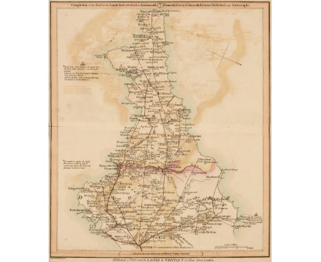
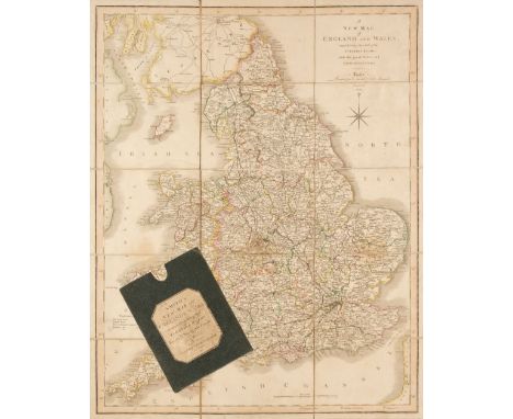
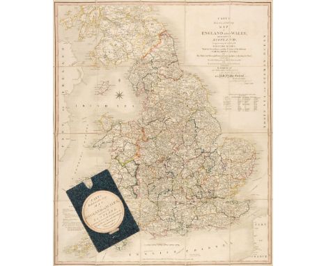
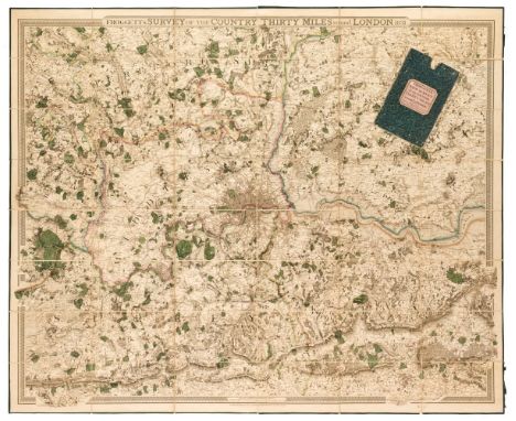
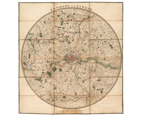
England & Wales. Cary (John), Cary's Reduction of his Large Map of England and Wales..., 1837, engraved map with bright contemporary outline colouring, sectionalised and laid on linen, marbled endpapers, 760 x 630 mm, contained in a contemporary card slipcase with publisher's circular printed label to the upper cover, together with Kitchin (Thomas). Kitchin's Enlarged Map of the Roads of England and Wales..., R. Sayer & J. Bennett, 1779, engraved map with contemporary outline colouring, sectionalised and laid on linen, large decorative uncoloured cartouche, and table of reference to the counties, 540 x 445 mm, contained in a contemporary marbled card slipcase with printed label to the upper cover, slipcase worn, with Faden (William). A Map of England, Wales & Scotland describing all the Direct and Principal Cross Roads in Great Britain..., 1800, engraved map with contemporary outline colouring, sectionalised and laid on linen, inset map of Scotland, slight staining and finger soiling, 735 x 610 mm, contained in a contemporary marbled card slipcase with printed label to the upper cover, slipcase worn and frayed, plus Coltman (Nathaniel). Laurie and Whittle's New Map of all the Coach Roads, Both Direct and Cross of England & Wales, with those of Scotland to the South of Edinburgh and Glasgow, April 12th 1809, engraved map with contemporary outline colouring, sectionalised and laid on linen, small holes where old folds cross, some dust and finger soiling, slight spotting and staining, 785 x 635 mm, contained in a contemporary marbled card slipcase with printed label to the upper cover, slipcase worn and frayed, and Bowles (Carington, publisher). A New and Correct Post Map of the Great and Cross Roads through England and Wales, laid down from all the Surveys hitherto made..., circa 1785, engraved map with contemporary outline colouring, sectionalised and laid on linen, old pinholes in each corner, 550 x 495 mm, contained in a contemporary marbled card slipcase with printed labels to the upper and rear covers, slipcase worn and frayed, together with Wyld (James). A Map of England, Wales & Scotland describing all the Direct and Principal Cross Roads in Great Britain..., Feby. 1st 1824, engraved map with contemporary outline colouring, sectionalised and laid on linen, inset map of Scotland, slight dust soiling and staining, 730 x 600 mm, contained in a contemporary marbled card slipcase with printed label to the upper cover, slipcase slight worn, with Thomson (John, publisher). England, circa 1825, engraved map with bright contemporary outline colouring, sectionalised and laid on linen, lists of the principal roads to the vertical margins, slight dust soiling, 650 x 805 mm, contained in a contemporary slipcase with a printed label to the upper cover, the title label reads 'A New Travelling Map of England...', slipcase heavily worn and frayedQTY: (7)

Lot 165

England & Wales. Ortelius (Abraham & Lhuyd Humphrey), Angliae Regni Florentissimi nova descriptio auctore Humfredo Lhuyd Denbygiense, [1579], hand coloured engraved map, lower corners torn with very slight loss, professionally restored, occasional repaired marginal worming, 390 x 475 mm, Latin text on verso, together with De Wit (Frederik). Anglia Regnum in Omnes suos Ducatus, Comitatus et Provincias Divisum, circa 1685, uncoloured engraved map, repaired closed tear affecting the printed image, slight offsetting, 585 x 495 mmQTY: (2)NOTE:The first described item. Marcel Van den Broecke. Ortelius Atlas Maps, number 19.

Lot 166

Essex. Speed (John & Norden John), Essex devided into Hundreds, with the most ancient and fayre Towne Colchester Described and other memorable Monuments observed, George Humble, circa 1627, hand coloured engraved map, inset town plan of Colchester, large strapwork cartouche, 385 x 510 mm, English text on versoQTY: (1)

Lot 168

* Europe. Mercator (Gerard), Europa, ad Magnae Europae Gerardi Mercatoris P. Imitationem, Rumoldi Mercatoris F. Cura Edita, Seruato Tamen Initio Longitudinis ex Ratione Magnetis, quod Pater in Magna sua Universali Posuit [1595 or later], engraved map with contemporary outline colouring, large strapwork cartouche, mounted, framed and double-glazed, French text on versoQTY: (1)

Lot 169

Falkland Islands. Bowles (Carrington & Carver T. publishers), Bowles's New One-Sheet Draught of Falkland Islands in the latitude of 52° 0' south, Longitude 60, 0 West from London, printed for Bowles and Carver, circa 1794, engraved map with contemporary outline colouring, eleven inset horizon profiles, slight overall toning with more pronounced spotting and toning to the margins, occasional repaired marginal closed tears, short split at the base of the central fold, 450 x 700 mm QTY: (1)NOTE:The chart depicts the routes of the British ships HMS Carcass and HMS Jason during their survey of the Falkland Islands in 1766 – shortly after Byron’s settling of Port Edgmond. Both English and French settlements are shown, and depth soundings, anchorages, islands and the numerous rocky outcrops that surround the islands. The cartography is based on Captain Macbride, who published an account of the survey in 1767.

Lot 172

* Germany & Poland. Coronelli (Vincenzo), Parte orientale Della Germania..., 1698, uncoloured engraved map of Poland, Eastern Germany and Austria, large strapwork cartouche, slight staining, 575 x 450 mm, mounted, framed and glazed, together with Jansson (Jan). Germaniae Veteris Typus..., circa 1648, hand-coloured engraved map, 380 x 480 mm, mounted, framed and glazed, with Tirion (Isaac & Albrizzi Giambatista). Circolo di Sassonia Superiore ouvero Sassonia, Misnia, Voigtland, Turgia, Anhalt, Lusazia, Brandenburg e Pomerania, Amsterdam, circa 1740, hand-coloured engraved map of the Saxony region of Germany & Poland, 290 x 340 mm, plus Berndt (Johann Christian). Carte topographique D'Allemagne Contenant ûne parties de la Neu Marc et les Frontieres du Royaume de Pologne..., Johann Wilhelm Abraham Jaeger, Frankfurt, circa 1780, engraved map with sparse contemporary outline colouring, 490 x 585 mmQTY: (4)

Lot 174

Japan. Hondius (Jodocus), Japonia, circa 1613, engraved map with contemporary outline colouring, large strapwork cartouche and mileage scale, one additional vertical crease, central fold with two small areas of repair to the verso, 345 x 445 mm, French text on versoQTY: (1)

Lot 177

Kent. Harris (John), A Map of the County of Kent, [1719], hand-coloured map on two conjoined sheets, engraved by Samuel Parker, 'picture frame' cartouche, inset panorama of Dover Castle and Town, the margins decorated with 118 heraldic coats of arms, old folds, some creasing, old folds strengthened on verso, 565 x 800 mmQTY: (1)

Lot 178

Lincolnshire. Speed (John), The Countie and Citie of Lincolne described with the Armes of them that have bene Earles thereof since the Conquest, Thomas Bassett & Richard Chiswell [1676], hand-coloured engraved map, inset town plan of Lincoln, large strapwork cartouche, compass rose and mileage scale, 385 x 510 mm, English text on versoQTY: (1)

Lot 179

* London. De Fer (Nicolas), Plan des Villes de Londres et de Westminster..., Paris, 1705, hand-coloured map engraved by C. Inselin, key late identifying 104 places and buildings of note,225 x 340 mm, mounted, framed and glazedQTY: (1)

Lot 180

London. Faden (William), The Country Twenty-Five Miles Round London, planned from a Scale of One Mile to an Inch, 1790, engraved map with contemporary outline colouring, sectionalised and laid on linen, slight oxidisation to old watercolour, very slight fraying and staining to the margins, 1025 x 1225 mm, contained in a contemporary marbled card slipcase, slight wear to the extremities, together with Bowles (Carington, publisher). Bowles's New Pocket Plan of the Cities of London and Westminster; with the Borough of Southwark: Comprehending the New Buildings and other alterations in the Year 1775, engraved map with contemporary outline colouring, sectionalised and laid on linen, some splits along old folds, 460 x 900 mm, contained in a contemporary marbled card slipcase, printed label to the upper cover, the slipcase worn and rubbed QTY: (2)NOTE:The first described item, James Howgego. The Printed Maps of London, number 188, state 3. The second item number 147 (a), state 3.

Lot 181

London. Froggett (J. W.), Froggett's Survey of the Country Thirty Miles Round London, 1831, engraved map with contemporary outline colouring, sectionalised and laid on linen, very slight offsetting, edged in green silk, 1115 x 1345 mm, marbled endpapers, contained in a contemporary card slipcase with printed label to the upper cover, together with Cary (John). Cary's Actual Survey of the Country Fifteen Miles round London..., June 20th 1800, untitled engraved map with contemporary outline colouring (the title is on the upper cover of the slipcase) sectionalised and laid on linen, slight staining, 760 x 885 mm, contained in a contemporary marbled card slipcase with printed title to the upper cover, slipcase worn and frayedQTY: (2)NOTE:The first described item. James Howgego, number 333, state 1. The second item. number 183, state 2.

Lot 182

London. Gill (MacDonald), Wonderground Map of London Town, The Westminster Press, circa 1928, photolithographic colour printed map, a few closed tears and splits along old folds, repaired and strengthened on verso, 745 x 930 mmQTY: (1)NOTE:This is an example of the slightly smaller and later edition of Gill's original 1913 map. There is a 1924 edition which is assumed to have been altered to help the promotion of the 1924 British Empire Exhibition that was held at Wembley between April and October of that year. It can be identified by a sign saying:- 'On To Wembley' and an empire lion in the top left hand corner below the man pushing a bus. This example is a slightly later state with a greyhound replacing the lion. Greyhound racing started at Wembley in 1927 so this edition probably dates from 1927 or 1928. The map remains highly stylised and whimsical and was held in great affection by Londoners. It was originally commissioned by The London Underground and was designed to be displayed in tube stations. The intense pictorial content of the map caught the public's imagination and as a result Gill is often credited with creating a resurgence of the genre of decorative map making. Much work and research has been done by Roderick Barron and Bryars & Bryars on the maps of the Underground and the work of Macdonald Gill and I am also grateful to Claire Dobbins book, London Underground Maps: Art, Design and Cartography.

Lot 183

London. Lee (Kerry), London. The Bastion of Liberty, circa 1950, large colour lithograph pictorial map of London, very slight creasing, 990 x 1230 mmQTY: (1)NOTE:A charming portrait of the artist Kerry Lee (1902 - 1988) can be seen in the lower right corner, his name signed on an easel with his faithful dog Jim, sitting by his side. Kerry Lee produced two colour pictorial maps for British Railways in the 1930s which were revised up until the 1950s. These railway posters are very much in the style of Macdonald Gill.

Lot 184

London. Wyld (James), Environs of London, 1840, engraved circular map with contemporary outline colouring, sectionalised and laid on linen, some staining and dust soiling, edged in green silk, diameter 580 mm, overall size 640 x 605 mm, together with Andriveau-Goujon (E. publisher). Environs de Paris dans un Rayon de 30 Kilometres, Paris, 1875, lithographic map with contemporary outline colouring, sectionalised and laid on linen, edged in brown silk, occasional small holes in the linen where old folds cross, short split along old fold, 825 x 1055 mm, contemporary manuscript title to rearQTY: (2)

Lot 185

Lotter (Tobias Conrad). Brittische Ubermacht zur See wieder Franckreich A°. 1759..., / Superiorite Britannique par Mer contre la France l'An 1759..., Augsburg circa 1760, engraved map after C. F. Heyden with contemporary outline colouring, showing the southern part of the British Isles, the Channel and the west coast of France, large decorative cartouche and additional text in French and German to the vertical margins, old ink library stamps to verso, one with slight show-through, 475 x 475 mmQTY: (1)NOTE:A scarce map of the Atlantic coast of France, showing the British blockade of the French ports at the height of the Seven Years' War.

Lot 187

Middlesex. Seale (Richard William), To the Most Noble Thomas Holles Pelham, Lord Lieutenant of Middlesex & Westminster....This Map of the County of Middlesex is Dedicated by his Grace's most humble Servant, Thomas & John Bowles, Robert Sayer & John Tinney, circa 1765, hand-coloured engraved map with the vertical margins decorated with the heraldic arms of ninety-two free and livery companies of London, central fold partially split and strengthened on verso, slight staining, 515 x 730 mm, together with Warburton (John, Bland Joseph & Symth Payler). [A New and Correct Mapp of Middlesex, Essex and Hertford-shire with the Roads, Rivers, Sea Coasts etc., Actually Surveyed by John Warburton Esq. Somerset Herald & F.R.S., Joseph Bland and Paylor Smyth, Gent.] circa 1725, the southwest sheet only of this large-scale map of Middlesex. two margins decorated with 144 heraldic shields, 540 x 630 mmQTY: (2)

Lot 19

Denham (Dixon & Hugh Clapperton). Narrative of Travels and Discoveries in Northern and Central Africa, in the Years 1822, 1823, and 1824, by Major Denham, Captain Clapperton, and the late Doctor Oudney. Extending across the Great Desert to the Tenth Degree of Northern Latitude, and from Kouka in Bornou to Sackatoo, the Capital of the Fellatah Empire, 1st edition, London: John Murray, 1826, engraved portrait frontispiece, folding map, 36 engraved plates and maps, including one hand-coloured aquatint, some light offsetting and toning, modern morocco-backed marbled boards, spine faded, 4toQTY: (1)

Lot 190

New Zealand. Benard (Robert), Carte de la Nle. Zelande visitée en 1769 et 1770 par le Lieutenant J.Cook Commandant de L'Endeavour Vaisseau de sa Majesté, Paris, [1774], uncoloured engraved map, old folds, small stain to the lower right of the map, 390 x 385 mmQTY: (1)NOTE:Originally published in Hawksworth's 'An Account of the Voyages..., in the Southern Hemisphere.

Lot 191

Norfolk. Speed (John), Norfolk a Countie florishing & populous described and devided with the armes of such noble familes as have borne the titles therof, Thomas Bassett & Richard Chiswell [1676], hand-coloured engraved map, inset town plan of Norwich, one small crease, 380 x 510 mm, English text on versoQTY: (1)

Lot 192

Norfolk. Speed (John), Norfolk a Countie florishing & populous described and devided with the armes of such noble familes as have borne the titles therof, 1st edition, John Sudbury & George Humble, [1611], hand-coloured engraved map, inset town plan of Norwich, central fold partially strengthened on verso, vertical margins extended, 385 x 510 mm, English text on versoQTY: (1)

Lot 194

* Northamptonshire. Blaeu (Johannes), Comitatus Northantonensis vernacule Northampton Shire, Amsterdam, circa 1645, engraved map with contemporary hand-colouring, large decorative cartouche and mileage scale, very slight staining, 410 x 495 mm, mounted, framed and glazed, together with Saxton (Christopher & Kip William). Northamtoniae comitatus Descriptio in quo Coritani Olim Insederunt [1637], hand-coloured engraved map, large strapwork cartouche and mileage scale, slight staining, 280 x 355 mm, mounted, framed and glazed, and another copy similar, with Bowen (Emanuel). An Accurate Map of Northampton Shire Divided into Hundreds and Laid down from the best Authorities..., Robert Sayer, T. & J. Bowles & John Tinney, circa 1760, engraved map with contemporary outline colouring and with some later enhancement to the cartouche and dedication, originally published in 'The Large English Atlas', toned overall, slight creasing, 700 x 535 mm, mounted, framed and glazed, with another copy similar, with Morden (Robert). Northamptonshire, circa 1695, hand-coloured engraved map, 355 x 420 mm, mounted, framed and glazed, plus Blome (Richard). A Mapp of the County of Northampton with its Hundreds, circa 1673, hand-coloured engraved map, toned overall, 255 x 315 mm, mounted, framed and glazedQTY: (7)

Lot 195

Northumberland. Saxton (Christopher), Northumbriae Comitatus (Scotiae contiguae) nova verag descriptio [1579], hand-coloured engraved map, large strapwork cartouche surmounted by the Royal crest and also bearing the arms of Thomas Seckford, central fold with small areas of repair on the verso, slight dust soiling, 380 x 460 mmQTY: (1)NOTE:The first printed map of Northumberland with the 'bunch of grapes' watermark.

Loading...Loading...
  • 109182 item(s)
    /page

Recently Viewed Lots