

NO RESERVE Map reference books.- Wright (Thomas) Clavis Cœlestis being the Explication of a Diagram entitled, a Synopsis of the Universe, edited by M. A. Hoskin, 4 double-page large folding facsimile diagrams, contemporary morocco-backed boards, slight bumping to corners and spine extremities, 1967 § Kenny (Louis A.) Catalogue of the Rare Astronomical Books in the San Diego State University Library, frontispiece, illustrations, some full-page, original cloth, a little rubbed, faded spine, slipcase, a little rubbed and faded, San Diego, 1988 § Levenson (Jay A., editor) Circa 1492: Art in the Age of Exploration, illustrations, original stiff paper wrappers, a little rubbed, 1992; and a small quantity of others, mostly celestial cartography, including periodicals, v.s. (small qty)
We found 109182 price guide item(s) matching your search
There are 109182 lots that match your search criteria. Subscribe now to get instant access to the full price guide service.
Click here to subscribe- List
- Grid
-
109182 item(s)/page

NO RESERVE British Isles.- Münster (Sebastian) Tabula Europae I, Ptolemaic map on a trapezoidal projection, two panels of text list the ancient tribes of Ireland and Britain, woodcut on laid paper, sheet 295 x 380 mm (11 5/8 x 15 in), Latin text on verso, small nick to centre right edge, minor spotting and surface dirt, unframed, [Basel, circa 1540-1570].
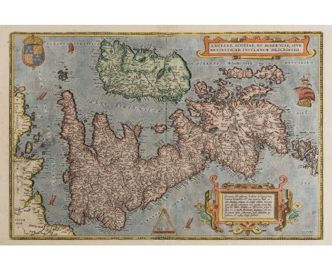
British Isles.- Ortelius (Abraham) Angliae, Scotiae, et Hiberniae, sive Britannicar Insularum Descriptio, Ortelius' earliest map of Britain, oriented with north to the right, and embellished with two ornate strapwork cartouches, a royal coat of arms, a compass and scale, and five sailing ships, engraving with hand-colouring on laid paper with watermark of crossed arrows, platemark 345 x 500 mm (13 1/2 x 19 3/4 in), sheet 405 x 560 mm (16 3/4 x 22 in), Latin text verso, central vertical fold with repaired splitting and small area of loss to border restored in facsimile, handling creases and cockling to sheet, surface dirt, small nicks to edges, unframed, [circa 1570 or slightly later]Literature:VdB 16
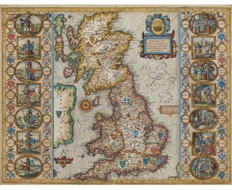
British Isles.- Speed (John) Britain as it was devided in the tyme of the Englishe Saxons especially during their Heptarchy, decorative map of the British Isles with compass rose and numerous rhumb lines, fourteen engraved vignettes of historical scenes and Saxon kings to the vertical margins, engraving with hand-colouring, on laid paper with armorial watermark, 390 x 510 mm. (15 1/4 x 20 in), under glass, English text verso, central vertical fold with careful repairs to splits and two areas of loss restored to foot, small hole in the upper section, small margins with left and right edges re-margined, framed, Sudbury and Humble [circa 1611 but slightly later].
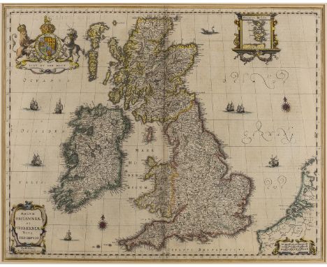
British Isles.- Jansson (Jan) Magnae Britanniae et Hiberniae nova descriptio, inset map of the Orkney Islands in the upper right corner, numerous sailing ships, two compass roses, and a sea monster just north off the coast of Aberdeen, engraving with outline hand-colouring, platemark 430 x 545 mm (16 7/8 x 21 1/2 in), sheet 470 x 550 mm (18 1/2 x 21 3/4 in), German text verso, central vertical fold reinforced with careful repair to splitting in the lower section, even toning and some minor spotting and surface dirt, taped at edges into mount, unframed, Amsterdam, [circa 1646]
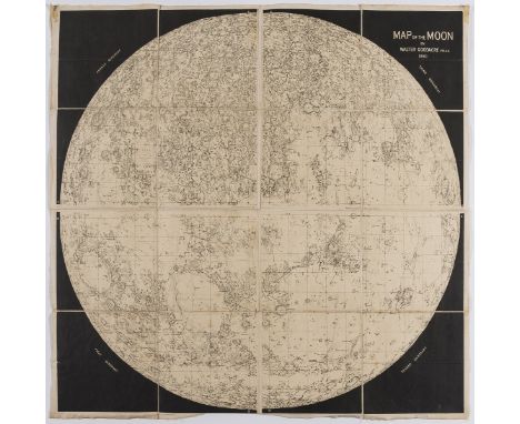
NO RESERVE Celestial.- Goodacre (Walter) Map of the Moon, reduced map based on Goodacre's 77" diameter manuscript map of the moon, lithograph, 650 x 660 mm (25 1/2 x 26 in), dissected and mounted on linen, some rubbing and scuff marks, folding without slipcase, 8vo, Vincent Brooks, Day & Son, [circa 1910 or slightly later]
*** Please note, the description of this lot has changed ***British Isles.- Bacon (George W., publisher) New Large Scale Ordnance Atlas of the British Isles..., 104 hand-coloured double-page lithographed maps, mounted on stubs, occasional spotting and minor browning, re-backed, modern half morocco, g.e., losses to inside marbled papers, minor rubbing, 4to, [c. 1883].*** Including regional and geological maps of Britain and Ireland, plans of towns and ports, a railway map of London and its suburbs, and a map of the Lakes of Killarney.


NO RESERVE England & Wales.- Ortelius (Abraham) and Lhuyd Humphrey. Cambriae Typus Auctore Humfredo Lhuydo. Denbigiense Cambrobritano, engraving with hand-colouring, 420 x 540 mm (16 1/2 x 21 1/4 in), Latin text verso, laid on thin tissue, numerous small repairs to losses within the map, other marginal losses from worm hole damage, some surface dirt and browning, unframed, [circa 1590-1605]; together with Angliae Regni Florentissimi Nova Descriptio, Auctore Humfredo Lhuyd Denbygiense, engraving with hand-colouring, sheet 400 x 540 mm (15 3/4 x 21 1/4 in), Latin text verso, margins slightly trimmed, some damp-stains that have affected watercolours, unframed, [circa 1590-1605] (2)
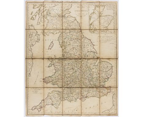
England & Wales.- Faden (William) The Roads of Great Britain, second edition, engraved map with outline hand-colouring, 750 x 610 mm (29 1/2 x 24 in), dissected and mounted on linen, some spotting and browning, folding into slipcase, printed label to upper cover, very worn, 8vo, 1790; together with Cary's Pocket Companion to the Roads of Great Britain, 1791, and 17 further folding maps of English counties, including J. & C. Walker's 'Sussex', John Cary's 'New Map of Durham', Stanford's 'Country Round Churt', and ordnance survey maps covering Hereford, Derbyshire, Bicester, Suffolk, Essex, and Kent, among others, various sizes, 8vo and 4to, mainly 19th century (19)
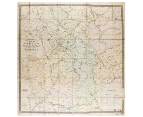
England.- Bradshaw (George) Bradshaw's Map of Canals, Navigable Rivers, Rail Road &c. in the Midland Counties of England from Actual Survey, said to be the second edition, enlarged to accommodate the development of the Grand Junction Canal from Stoke Hammond to Tring, large-scale map centred on Birmingham, with decorative border and calligraphic title, engraving with hand-colouring, 1380 x 1280 mm (54 1/4 x 50 3/8 in), dissected and mounted on linen, a clean bright impression with some offsetting, edged with green linen, some coming loose, folding without slipcase, 8vo, 1830


Ireland.- Cary (John) Cary's New Map of Ireland, exhibiting the whole of the Turnpike Roads with the Rivers and Canals, engraving with original hand-colouring in outline, 770 x 620 mm (30 x 24 1/4 in), dissected and linen-backed, original marbled slipcase with large label, edges rubbed, 8vo, 1832

NO RESERVE Essex.- Map (A) of the County of Essex from an Actual Survey, folding sheet backed onto linen, faint spotting, some slight chipping to edges, housed in contemporary marbled sleeve, rubbed and worn, 480 x 600 mm, John Chapman and Peter André, 1777 § The Official Map of Epping Forest ... Authenticated by the signature of the Arbitrator Sir Arthur Hobhouse, folding hand-coloured sheet backed onto linen, housed in contemporary cloth boards, 1080 x 685 mm, 1883; and 4 others, all maps of Essex (6)

NO RESERVE Essex.- Cary (John) A Map of Essex from the best Authorities, engraving with hand-colouring, platemark 450 x 550 mm (17 3/4 x 21 3/4 in), some handling creases and surface dirt, unframed, 1805; together with 21 others, including 10 maps of Essex by Moll, Slater, Dugdale, Cary, and other county maps including Jansson's 'Mervinia et Montgomeria', Bowen's 'Herefordshire Divided', Greenwood's 'Monmouth' and 'Middlesex', amongst others, engravings, many with hand-colouring, various sizes, some laid down, nicks, tears and handling creases throughout, surface dirt, all unframed, mainly 18th and 19th century (22)

Lancashire.- Hennet (George) A Map of the County Palatine of Lancaster, large county map with ornate title and vignette view of the New Custom House, Liverpool, in the upper right quadrant, engraving by James Bingley, with original hand-colouring, 1620 x 1155 mm (63 3/4 x 45 1/2 in), dissected and linen-backed, edged in green silk, some light browning and offsetting, minor surface dirt, folding with green marbled endpapers, contemporary tree calf book-style slipcase, corners bumped, some rubbing, 4to, Henry Teesdale, 1830.

London.- Münster (Sebastian) Londen oder Lunden die Hauptstatt in Engellande, bird's-eye plan/view of Westminster, the City and Southwark, for Munster's 'Cosmographia', German title above with Latin title banderole in upper centre of plan, arms in upper corners, large costume figures lower centre, woodcut map with hand-colouring on thin laid paper, 310 x 390 mm (12 1/4 x 15 1/4 in), German text verso with page numbers in Roman numerals, central vertical fold with some parallel creases, other minor handling creases, [Howgego 6 (1)], Basel, [1598]

London and its environs.- Speed (John) Midle-Sex described with the most famous Cities of London and Westminster, with inset plans and views of St Paul's and Westminster Abbey, engraved map with hand-colouring, on laid paper with fleur-de-lis, platemark 380 x 510 mm (15 x 20 in), sheet 420 x 540 mm (16 1/2 x 21 1/4 in), central vertical fold with careful repairs to splitting visible verso, parallel creases, lower margin repaired, nicks and small tears to edges, minor surface dirt, unframed, Bassett and Chiswell, [1676]

London.- Homann Heirs. Regionis, quae est circa Londinum, specialis repræsentatio geographica, map of the environs of London, from Maidenhead to Bishop's Stortford, and Chelmsford to Leatherhead, with panoramic view of the River Thames below, engraving with hand-colouring on laid paper with cross-based watermark, sheet 525 x 580 mm. (20 3/4 x 22 3/4 in), central vertical fold as issued, reinforced verso, minor handling creases, surface dirt and faint marginal damp-stain in the upper right corner, not affecting the map, unframed, 1741.

Africa.- Ortelius (Abraham) Africae Tabula Nova, map of the African continent, with Madagascar and part of the Arabian Gulf, Zanzibar is shown on the west coast, decorated with a large strapwork title cartouche, a grand sea battle, fantastic sea creatures, engraving with fine early hand-colouring, on laid paper with watermark of small armorial device with indistinct text below, platemark 376 x 505 mm. (14 3/4 x 19 7/8 in), sheet 400 x 530 mm. (15 3/4 x 20 7/8 in), under glass, minor offsetting, light surface dirt, framed, [1570 or later].Literature:VdB 8
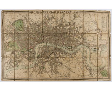
NO RESERVE London.- Cross (Joseph) Cross's New Plan of London, 1828, first edition, showing from Canonbury to Camberwell, and from Hyde Park to East India Dock, engraved map with original hand-colouring, 660 x 1000 mm (26 x 39 1/4 in), dissected and mounted on linen, several splits and tears to folds, the upper right corner detached with taped in, surface dirt and browning, folding without slipcase, 8vo, 1828Literature:Howgego 317 (1)

London.- Wallis (Edward, publisher) Wallis's Guide for Strangers through London, showing from Hyde Park to Whitechapel, engraving with hand-colouring, 420 x 670 mm (16 1/2 x 26 1/4 in), dissected and mounted on linen, letterpress title and key present but detached from main map, in three sections, otherwise some minor surface dirt, folding into contemporary slipcase with printed label to upper cover, worn, [Howgego 301 (6)], 1831; together with 6 further folding maps of London, including two variant copies of C. Smith & Sons 'Tape Indicator Map of London', and 3 guides to London with printed maps, various sizes, 8vo, 19th and 20th century (10)
NO RESERVE London.- Thompson (George) A New Map of London and its Environs, from an original Survey, Extending 8 Miles East and West 6 1/4 Miles North & South..., first edition, showing from Paddington to East India Docks, and Clapton to Camberwell, with decorative border and large calligraphic title, engraving with hand-colouring, 640 x 795 mm (25 1/4 x 31 1/4 in), dissected and mounted on linen, numerous splits to folds, upper left section attached with tape, some spotting and browning, folding without slipcase, 8vo, Reeves & Hoare, 1823.
London.- Newton (William) London Westminster Southwark as in Olden Times shewing the City and Suburbs, large wall map, lithograph printed in colours, several sheets conjoined, total sheet approx. 1375 x 1020 mm (54 1/8 x 40 1/8 in), laid on linen, some surfaced dirt and browning, handling creases and some cockling, rolled, 1855.

Africa.- Morocco.- Ortelius (Abraham) Fessae et Marocchi regna Africae celeberr describebat, inset map of West-Africa based on Pigafetta's map of the Congo, large decorated strapwork cartouche in the lower right corner, with sailing ships and sea monster, engraving with hand-colouring, on laid paper with indistinct armorial watermark, sheet 397 x 515 mm (15 1/2 x 20 1/4 in), English text verso, central vertical fold with repairs to splitting at head and foot, some parallel creases, other handling creases, nicks and loss to edges, particularly to lower right corner just affecting the border, unframed, circa 1595 [or slightly later].Literature:VdB 177

NO RESERVE London.- Dower (John James) London, Guide to the International Exhibition, 1862, issued as a supplement to the Illustrated London News, showing from Highgate to Clapham, and from Wormwood Scrubs to the East India Docks, lithographed map, 775 x 1085 mm (30 1/2 x 42 3/4 in), old folds with some splitting into the map, handling creases and some nicks and tears to edges, [cf. Hyde 82], 1862

London.- Weller (Edward) London, large nine sheet wall map, from the Weekly Dispatch, lithographs with full hand-colouring, conjoined in 3 horizontal strips, each approx. 480 x 1920 mm (18 7/8 x 75 1/2 in), some old folds with repairde splitting, a few marginal nicks and tears, otherwise some minor surface dirt and browning, unframed, 1863.

London.- Weller (Edward) London in the Reign of Queen Elizabeth, A Fac-simile (Reduced) of the Map by Aggas 1560, bird's-eye plan/view of London, with decorative title cartouche lower left, key panel lower centre and arms above, lithographed map on 2 sheets conjoined, with full hand-colouring, 480 x 1250 mm (18 7/8 x 49 1/4 in), faint old vertical vertical folds, a few short marginal splits, one tear in the right margin extending just into the image, issued by The Weekly Dispatch, [1863].
NO RESERVE London.- Bacon (George W.) New Map of London, divided into half mile squares & circles, from Cassell's Old & New London, lithograph with some hand-colouring, sheet 750 x 980 mm (29 1/2 x 38 1/2 in), old folds with one or two small splits, some surface dirt and browning, the left edge slightly rough and trimmed to borderline, Cassell, Peter Galpin & Co., [circa 1880]; with another copy of the same, uncoloured, and with 6 other folding maps of London, all in compromised conditions, including Cassell's 'Map of London published with Cassell's Family Paper', late 19th century or slightly later (8)
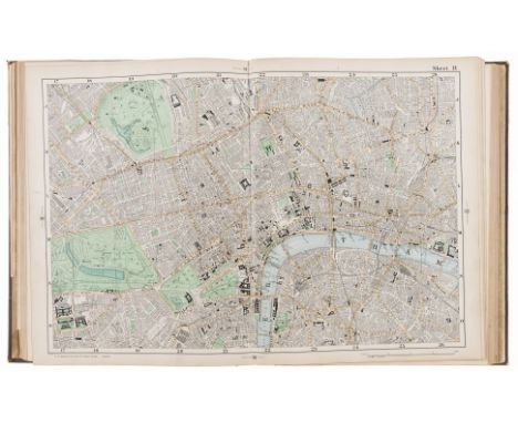
London.- Bacon (George W., publisher) Bacon's New Large Scale Atlas of London and Suburbs with Supplementary Maps, Letterpress Descriptions and Alphabetical Index, complete with title, contents, three sets of index, index map, and 46 double-page maps, lithographs with some hand-colouring, each approx. 350 x 525 mm. (13 3/4 x 20 3/4 in), some tabs with tears into text leaves, a few repaired, otherwise occasional minor surface dirt but good clean maps, original cloth, gilt, slight rubbing with label to spine, folio, 1906.

NO RESERVE London.- Davies (Benjamin Rees) Davies' New map of London and its Environs, Showing the New Railway Stations and Other Improvements, from Finchley to Anerley, and from Barking Level to Hanwell, lithographed map with hand-colouring, 760 x 1115 mm (29 7/8 x 45 1/4 in), dissected and mounted on linen, minor surface dirt, folding into purple cloth slipcase with publisher's green label pasted on upper cover, worn, Edward Stanford, 1894Literature:cf. Howgego 372
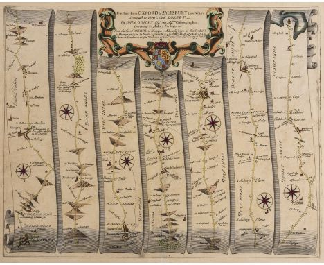
Oxford.- Ogilby (John) The Road from Oxford to Salisbury Com. Wilts Continued to Pool Com. Dorset, strip road map commencing at Oxford and runs through Abingdon, Hungerford, Salisbury, Cranbourne and Wimborne Minster and ends at Poole, sheet number 83, engraving with hand-colouring on laid paper with text-based watermark, sheet 385 x 475 mm (15 1/8 x 18 3/4 in), central vertical fold reinforced verso, some spotting, browning and surface dirt, minor handling creases, unframed, [circa 1676]

World.- Münster (Sebastian) Typus Orbis Universalis, map of the world presented on an oval projection surrounded by clouds and wind heads with the title above the map, with the continents shown only in rough outline, woodcut on thin laid paper without watermark, sheet 308 x 385 mm. (12 1/2 x 15 7/8 in), Latin title and text verso, central vertical fold with creases to head and foort, minor splitting, trimmed to border at upper left and right, repaired marginal tear in the upper right corner, unframed, [Basel, circa 1550]Literature:Shirley, World, no. 92 1550.

Africa.- Blome (Richard) A Mapp of the Higher and Lower Aethiopia Comprehending ye Several Kingdomes..., with elaborate heraldic cartouche and a dedication to William Glynne, from Blome's 'Geographical Description Of The Four Parts Of The World', engraving with hand-colouring, 310 x 415 mm (12 1/4 x 16 1/8 in), under glass, minor spotting and browning, a few creases, framed, [1669]⁂ Said to be the earliest folio sized map of the region engraved in England.

Africa.- Speed (John) Africae, described, the manners of their habits, and buildings, the first map of Africa prepared by an English cartographer, filled with fictitious mountains, rivers and lakes, with a panel of eight plans illustrating Tanger, Ceuta, Alger, Tunis, Alexandria, Cairo (Alca), Mozambique and the Canaries, and two panels of five figures along the left and right of the map, engraving with hand-colouring on laid paper with armorial watermark, platemark 400 x 515 mm (15 3/4 x 20 1/4 in), sheet 410 x 530 mm (16 1/8 x 20 7/8 in), English text verso with ruled red ink borders, central vertical fold with some carefully repaired splitting, several fine printers' creases with splits, surface dirt and brown edges, handling creases, unframed, Basset & Chiswell, [1676].

Africa.- Seutter (Matthäus) Africa Iuxta Navigationes et Observationes Recentissimas Aucta Correcta et in sua Regna et Status Divisa, map of Africa based largely on Homann's 1715 map, with Madagascar and part of the Arabian Peninsula in the upper right, engraving with hand-colouring on laid paper, sheet 545 x 615 mm. (21 1/2 x 24 1/4 in), marginal surface dirt, some minor spotting and browning, unframed, [circa 1730].

South Africa.- De L'Isle (Guillaume) Carta Geografica Capo del Buona Speranza, scarce map showing the second early expansion of the Cape of Good Hope Settlement beyond The Castle, with illustrated title vignette in the lower left corner, engraving with hand-colouring, 350 x 440 mm (13 3/4 x 17 1/4 in), under glass, numbered in ink '117' upper right corner, framed, [circa 1750]; together with an engraved view, 'Gezicht op Kaap de Goede Hoop', showing the Cape of Good Hope, 290 x 380 mm (11 1/2 x 14 7/8 in), under glass, framed, 18th century (2).
NO RESERVE America.- Colonial Southern United States, Florida.- Gibson (John) A Map of the New Governments, of East & West Florida, with inset plan of the Harbour and Settlement of Pensacola, published in November 1763 just a few weeks after the British acquisition of Florida at the conclusion of the French and Indian War, with the region divided into two British provinces, East and West Florida, engraving, 210 x 260 mm (8 1/4 x 10 1/4 in), folds as issued, unframed, 1763; together with 'The British Governments in Nth. America Laid Down Agreeable to the Proclamation of Octr. 7. 1763', and another from the same without title, showing Louisiana, Virginia, Carolina, and part of Florida, engravings, each approx. 210 x 260 mm (8 1/4 x 10 1/4 in), old folds, unframed, 1763 (3)

America.- West Indies.- Sayer (Robert) and John Bennett. A New and Correct Map of North America, with the West India Islands. Divided According to the Last Treaty of Peace..., large detailed 4 sheet map of American Revolution of interest, with inset entitled 'The Passage by Land to California, discovered by Father Eusebius Francis Kino, a Jesuit, between the years 1698 and 1701, before which, and for a considerable time since California has been described in all charts as an Island', with two large rococo-style cartouches, engraving with outline hand-colouring, 2 sheets conjoined in horizontal sections, each approx. 535 x 1180 mm (21 x 46 1/2 in), old folds and handling creases, minor spotting and surface dirt, unframed, 1779.

America.- Reid (John) The American Atlas, title with contents, 21 engraved maps, including the added folding plan of Washington D.C, some ink marginalia with various names to verso of title and plan of Washington, heavily damp-stained throughout with severe surface dirt and browning, the map of Maine with some loss, but a duplicate loose copy of the Maine map is included, otherwise tears, rough edges, folds, and some occasional small losses, held together loose in contemporary boards, very worn with losses, folio, 1796; sold not subject to return.⁂ The second American atlas of the United States
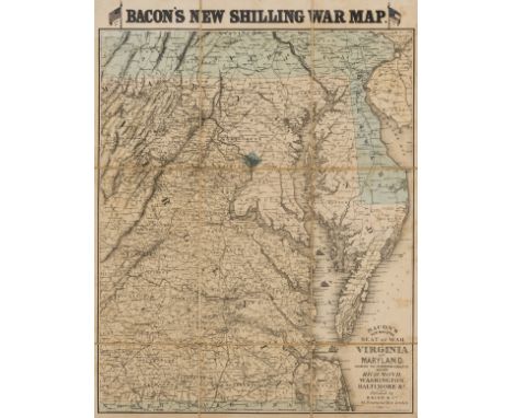
America.- Virginia.- Bacon (George W.) Bacon's New Map of the Seat of War in Virginia and Maryland, showing the interesting localities around Richmond, Washington, Baltimore &c., lithograph with some hand-colouring to upper section and confederate and federal flags, sheet 620 x 485 mm (24 1/4 x 19 in), under glass, dissected and mounted on linen, some spotting and browning, framed, Bacon & Co., 1862.

World.- Apianus (Petrus) La Cosmographia, corregida y añadida por Gemma Frisio, collation: A-Y⁴, title with large woodcut of globe, numerous woodcut illustrations and initials including 4 volvelles (C2 ͮ, D1 ͮ, I1 ͬ misbound & P3 ͬ), folding woodcut map of world detached, loosely inserted, small repair to edge, I1 taken from a different edition and misbound as I4, ink manuscript notes to title, occasional scattered spotting, bookplate, near contemporary limp vellum, a little browned, title in manuscript to spine, [Sabin 1756], 4to, Anvers, Juan Bellero, 1575.
![Americas.- Florida.- Peru.- Ortelius (Abraham) Peruviae Auriferae Regionis Typus [on sheet with] La Florida [and] Guastecan R](https://cdn.globalauctionplatform.com/1f04a71e-3481-4336-9147-ac3f00bffaf2/cfb825c1-4876-4a64-b878-ac3f00c793d1/468x382.jpg)
Americas.- Florida.- Peru.- Ortelius (Abraham) Peruviae Auriferae Regionis Typus [on sheet with] La Florida [and] Guastecan Reg, three maps on one sheet based on original Spanish sources, illustrating the Gulf of Mexico, Florida, and Peru, engraving with fine early hand-colouring, platemark 340 x 470 mm. (13 1/2 x 18 1/2 in), sheet 475 x 580 mm. (18 3/4 x 22 3/4 in), good margins, with Spanish text verso, central vertical fold with careful repairs to splitting, diagonal fold running through Peru, marginal minor surface dirt and finger-soiling, unframed, [Antwerp, 1609].Literature:VdB 15⁂ The sources used to produce the map were said to have been compiled by Geronimo de Chaves, and were largely based on the expedition of Hernando de Soto, 1539-42.
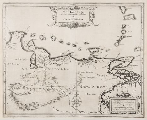
NO RESERVE South America.- De Laet (Johannes) Venezuela ende het Westelyckste Gedeelte van Nueva Andalusia, map of Venezuela, with ornamental title cartouche and separate scale of distance, engraving on laid paper with armorial watermark, platemark 282 x 360 mm. (11 1/8 x 14 1/4 in), sheet 306 x 377 mm. (12 x 14 7/8 in), central vertical fold as issued, handling creases and minor nicks to edges, unframed, [?Amsterdam, circa 1630].

South America.- Bolton (Solomon) South America. Performed Under the Patronage of Louis Duke of Orleans First Prince of the Blood, by the Sieur D'Anville..., large three sheet map of the continent, with large rococo-style cartouche in the lower right corner, engraving by Thomas Kitchin, original hand-colouring on laid paper, three sheets not joined, each approx. 425 x 800 mm. (16 3/4 x 31 1/2 in), folds as issued, some with repairs verso to splitting, some offsetting and browning, handling creases and small nicks to edges, unframed, 1755.

South America.- Schraembl (Franz Anton) Karte von Sud-America Verfasst von Herrn d'Anville Geographen des Konigs von Frankreich, large and impressive three sheet map of the continent based on D'Anville's map of 1748, engraving with original hand-colouring on thick watermarked laid paper, three sheets not joined, each approx. 615 x 850 mm. (24 1/4 x 33 1/2 in), central vertical folds as issued, repairs to splitting verso, handling creases, minor surface dirt, marginal nicks and tears, some repaired, unframed, 1786.

Asia.- Speed (John) A Newe Mape of Tartary, detailed map showing from Lake Baikal through the regions of present-day Manchuria and Siberia to the north of the Great Wall of China, with Korea as an Island, featuring 8 side panels with the people of Tartary in their native costume, and four vignette views above of Nova Zembla, and the silk route cities of Astrakan, Samarkand and Cambalu, engraving with hand-colouring, platemark 400 x 515 mm (15 3/4 x 20 1/4 in), sheet 430 x 560 mm. (17 x 22 in), central vertical fold with careful repairs to splitting verso, upper margin with losses, nicks and tears, other edges slightly rough, printers' crease in the lower right corner, other handling creases and surface dirt, unframed, Bassett and Chiswell, [1676].

Asia.- Homann (Johann Christoph) Asiae Recentissima Delineatio, map of Asia showing from Egypt across the Arabian Peninsula, India, China, and Japan, decorated with two large cartouches, engraving with hand-colouring on laid paper, platemark 495 x 590 mm. (19 1/2 x 23 1/4 in), sheet 515 x 595 mm. (20 1/4 x 23 1/2 in), central vertical fold with parallel splitting repaired verso, otherwise some surface dirt and browning, minor marginal nicks and tears to extremities, unframed, Nuremberg, [circa 1750]
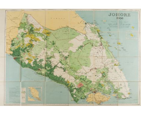
NO RESERVE Singapore & Malaysia.- Survey Dept. (Federation of Malaya) Johore, 1950, detailed map showing the topography of the region, with Singapore in the lower right, lithograph map printed in colours, 1028 x 1290 mm (40 1/2 x 50 3/4 in), dissected and mounted on linen, a few minor spots and surface dirt, folding into contemporary green cloth boards, rubbed and scuffed, 4to, 1950


China.- Blaeu (Willem Jansz.) China Veteribus Sinarum Regio nunc Incolis Tame dicta, map of Eastern China, with Japan, Korea as an island, and the northern Philippines, with large decorative title cartouche supported by Chinese courtly costume figures, upper right, and an armorial dedication cartouche to Theodore Bas, director of the Dutch East India Company, lower centre, European sailing ships and Chinese junks, engraving with early hand-colouring, platemark 410 x 500 mm (16 x 19 3/4 in), sheet 440 x 540 mm (17 1/4 x 21 1/4 in), Dutch text on verso, a repaired split and some creasing on the central vertical fold, a horizontal crease, a marginal tear to the lower left edge, some browning and surface dirt, unframed, Amsterdam, [circa 1640]
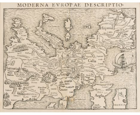
Europe.- Münster (Sebastian) Moderna Europae Descriptio, map of Europe with north oriented to the south, showing part of the British Isles in the lower section, and with the Mediterranean in the north, woodcut on laid paper, 290 x 370 mm (11 1/2 x 14 1/2 in), central vertical fold as issued, minor browning, unframed, [circa 1550]; together with Münster's 'In monte casio iuxta ostracinam. . . [Israel with Cyprus]', woodcut, 290 x 190 mm (11 1/2 x 7 1/2 in), unframed, [circa 1550] (2)⁂ One of the earliest obtainable maps of the European continent.
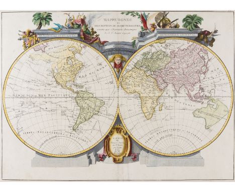
World.- Santini (Francois) and Jean Janvier. Mappe Monde ou Description du Globe Terrestre, double-hemisphere world map pre-dating Cook's last voyage to the Pacific and before a wider awareness of Russian exploration around Alaska, showing incomplete coastlines for Australia, New Zealand and the north west of North America, engraving with hand-colouring on laid paper with watermark of the letter 'R', 490 x 665 mm (19 1/4 x 26 1/4 in), central vertical fold with some expert restoration to loss at centre, parallel creases, otherwise minor surface dirt and browning, unframed, Giovanni Antonio Remondini, Venice, [circa 1775]

Europe.- Visscher (Nicolas) Europa delineata et recens edita..., engraved map with early hand-colouring, on laid paper, platemark 440 x 560 mm (17 1/4 x 22 in), sheet 525 x 605 mm (20 3/4 x 23 3/4 in), mounted on old paper support, central vertical fold with repaired splitting, marginal handling creases, exposure lines and even toning, unframed, [circa 1677].

NO RESERVE France.- Anonymous. Manuscript map chart of the Pointe du Raz, Brittany, pen and ink map over pencil, on laid paper with watermark date '1799', sheet irregularly trimmed, but approx. 320 x 390 mm (12 1/2 x 15 3/8 in), some spotting and offsetting, old folds and handling creases, some surface dirt, unframed, [1799]; together with manuscript letter with 'Directions for the [?]Bec du [?]Reu Passage' near the The Îles des Saintes, pen and brown ink, 155 x 200 mm (6 1/8 x 7 7/8 in), unframed, [circa 1800] (2).

NO RESERVE France.- Lorrain.- Braun (Georg) and Franz Hogenberg. Metz, bird's-eye view of Metz showing the fortified city surrounded by the Seille and Moselle Rivers, with numbered key at bottom right and Saint-Etienne de Metz cathedral shown in the upper centre of the city plan, engraving on laid paper, sheet 405 x 540 mm. (16 x 21 1/4 in), good margins, Latin text verso, handling creases, marginal nicks, some browning and surface dirt, unframed, c. 1575 [or slightly later]; together with a map and plan of The Wards of Coleman Street and Bassishaw from 1772, unframed (2).

France.- A group of maps including Braun & Hogenberg's plans of Macon and Chalons, engraving with hand-colouring, c. 1617; F.de Witt's Generalis Lotharingiae, map of Lorraine in outline hand-colour, c.1680; G.de l'Isle's Carte du Bearn, de la Bigorre, de l'Armagnac et des pays voisins, map of south-west France in outline hand colour, Covens & Mortier, c. 1720; Sanson's Dauphine, outline hand-colour, clean tear, Jaillot, 1692; and 10 others, generally in good condition, 17th and 18th centuries (14)

Germany.- Mejer (Johannes, 1606-1674) Newe Landcarte von denbeiden Herzogthumbern Schleswieg und Holstein, Anno 1650, engraved map of Schleswig-Holstein from Hamburg north to Denmark, with original hand-colouring, large title cartouche at top right, side borders with 18 town plans including Hamburg, Kiel, Flensburg, Schleswig and Husum, 420 x 590 mm (16 3/4 x 23 1/2 in), uniform browning, extreme sheet edges reinforced verso, faint contemporary paper flaw backed with old paper, unframed, Husum [1652]

Germany.- Nell (Johann Peter, 1672-1743) Neu-vermehrte Post-Charte durch gantz Teutschland, engraved map with original hand-colouring in outline, 500 x 580 mm (19 3/4 x 22 3/4 in.), Latin title cartouche at top left, minor creasing reinforced verso, some surface dirt, unframed, Nuremberg, J.B. Homann, [circa 1730]

Holy Land.- Sanson (Nicolas) Judaea seu Terra Sancta quae Hebraeorum sive Israelitarum, large map of the Holy Land divided into tribes, engraving with some early hand-colouring, on two sheets conjoined, total platemark 570 x 845 mm (22 1/2 x 33 1/4 in), sheet 637 x 960 mm (25 x 37 3/4 in), minor handling creases, some rough edges with a few nicks and tears, even browning and surface dirt, unframed, Hubert Jaillot, Paris, 1696.
-
109182 item(s)/page