We found 109182 price guide item(s) matching your search

Refine your search

Year

Filter by Price Range
  • List
  • Grid
  • 109182 item(s)
    /page

Lot 227

A Christopher Saxton map of Warwickshire. 16' x 20'

Lot 252

A Drayton map of Cardigan from the Poly-Olbion. No. 6. Engraved William Hole. 10 1/2' x 13 1/2'

Lot 229

A map of Glamorgan Shyre by John Speede. Double framed. 16' x 21'

Lot 140

A John Bartholomew Imperial Atlas of England and Wales (complete) and a 1976 facsimile A Large and Accurate Map of The City of London by John Ogilby after the Morgan Survey of 1676

Lot 253

A map of Radnorshire by Jan Jannson 1588-1664. Taken from the final Latin edition of Jannson's Atlas 1659. 16' x 20'

Lot 37

A 18th Century Folding Protractor Map Frame, with brass hinges and stamped numbers, chip to one corner

Lot 288

Pictures and prints: to include an 18thC coloured edition of Robert Morden's map 'Buckinghamshire' 9'' x 7'' in a gilt frame BSR

Lot 2390

H Moll - Geographer Map of Nottinghamshire, hand coloured outlines 18th Century

Lot 2367

A framed map, Northamptonshire, John Speed, hand tinted, glazed both sides

Lot 2388

Derbyshire Interest: A circa 1970s 'A View of that Beautiful Cascade near Matlock Bath in Derbyshire' printed by Robt. Sayer map and print seller 33 Fleet Street London; a copper engraving 0 sticker verso, hand coloured

Lot 4109

A collection of railway books, maps, etc to include Ports of the LNER 1927, Ports owned by LMS 1932, Railway Clearing House map of Scotland 1923 and two copper printing plates of dockyard scenes

Lot 486

Ward Lock's Motor Road Map of Great Britain, mounted on linen, ten miles to inch, circa 1930

Lot 2416

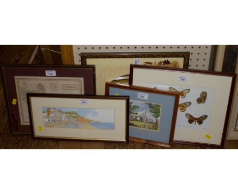
A collection of various pictures, including an etching, entitled Ightham Mote House; together with three further etchings, a framed photographic print of a Lion, a pair of signed Baxter prints, a canvas print depicting two ladies drinking, a reproduction map of Staffordshire; together with one watercolour, signed indistinctly, etc
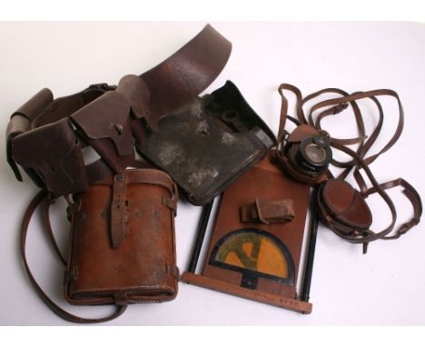
Lot 906

Vintage 50's Pygmalion Golden Globe Powder Compact - Fabulous golden globe with engraved world map markings. Powder puff and sifter with original bag.

Lot 78

A rare Britains 'Cow of the World' a retooled casting of the standard Britains model to feature a map of the world on each side together with the wording 'The World Cow and Nestles Milk', believed to have been made for the Empire Exhibition of 1924

Lot 237

Old framed map of Somerset

Lot 372

Various map and guide books

Lot 138

Cary, John, a coloured map, A New Map of the United Provinces Comprehending Holland, Zealand, Utrecht, Gelders, Over Yssel, Friesland and Groningen, with the Lands of Drent, Dutch Flanders, & Dutch Brabant &c &c From the Latest Authorities, 47cm x 53cm

Lot 532

CHURTON (Edward) - The Railroad Book of England with a Brief Sketch of the Lines in Scotland and Wales, hardback, with index, 1851, includes fold-out map and many engravings

Lot 531

BRADSHAW - New Railway Map of Great Britain and Ireland shewing the Stations, Distance etc with Enlarged Plans of the Principal Towns..... 1873, hand coloured ++new linen backing

Lot 287

A quantity of mixed ephemera including Girl Guiding Handbook c.1930's; some 1878 copies of The Home Visitor magazine; London Transport Central Buses route map; programmes; booklets and other similar items (a lot)

Lot 389

Rare British Military Advisory Training Team Zimbabwe (BMATT) Formation Sign, white rectangle with printed shield, BMATT and ZIMBABWE to the top and bottom, map of Zimbabwe to the centre of the shield with combined operations insignia set over the top. Good overall condition.

Lot 450

WW2 Dispatch Riders Overcoat, of heavy canvas material with large map pocket to breast and lower pockets. Complete with the waist belt. Clear makers stamp and 1943 date. Original label to the inside also with makers details and date 1943. Generally good condition.

Lot 524

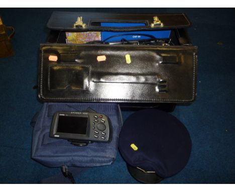
Selection of Great War British Officers Equipment consisting of 1915 dated Royal Flying Corps / Cavalry officers map board with compass fitted to the top. Made by Houghton-Butcher London. 1915 dated British officers Swiss made compass housed in the original brown leather field cover case, 1916 dated officers compass housed in the original field cover case, British officers field binoculars housed in the original 1918 dated brown leather carry case, 1915 dated trench saw complete with the wooden handles and leather carry case. WW2 1942 dated ammunition bandolier with War Department India acceptance stamp. (6 items)

Lot 1443

TALISKER 10 YEAR OLD MAP LABEL Single Island Malt Whisky, Old Style packaging and label. 70cl, 45.8% volume. In box.

Lot 145

A map of Berkshire, engraved by J. Cary, later hand coloured, 42cm x 54cm

Lot 120

A map of Berkshire, engraved by Sidney Hall, published by Chapman & Hall 1833, later hand coloured, 20cm x 26cm A Sidmouth Seafront by Eleanor Ludgate, 8.5cm x 27cm Two other prints and a mirror (5)

Lot 106

A British Railways 1950 Rule Book and a Rail Maintenance map.

Lot 225

A framed Railway Poster and a map.

Lot 78

A leather bound folding 'Jackson's Map of the Bramham Moor Hunt'.

Lot 303

A GARMIN GPS MAP 295 PILOTS NAVIGATION SYSTEM, not tested, with instructions, mounting bracket, etc, together with items relating to training to be a pilot, books, maps, headphones, etc

Lot 1146

Detailed hand coloured map of Essex by W.H Toms 1741 presented framed. Complete with gazeteer to the side. Frame 29 x29 cm

Lot 1078

Map of Russia by Abraham Ortelius, Pontus euxinus 1590 Contemporary handcoloured engraved, framed and glazed

Lot 1133

Framed Map of Huntingdonshire published by J Cary approx size with frame 12" x 14"

Lot 1076

18th Century map of Radnor Shire by Thomas Kitchen, framed and glazed

Lot 1098

WW2 Parachute Regiment Escape Map, Zones of France. 2nd.Edition, March 1944. Printed in colour on silk

Lot 1077

Large map of Australia by James Wyld Geographer to the Queen printed on linen backed paper, some wear on the folds.

Lot 1164

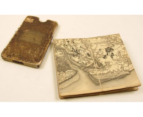
Shipping ledger, circa 18th Century, containing records of eighty-four people, including name, place of birth, the date they gained their ships license, which waters they can travel on and the tonnage of ship they can control. It also lists the name of the ship the person was in charge of, when they were in charge of it and the places they travelled from and to., including Yarmouth, Lowestoft, Norway, Riga, Amsterdam etc., contemporary vellum boards, folio together with a manuscript book of tides, c. 19th century, relating to East Anglia, Princes channel, Knob channel, etc., contemporary morocco, 8vo, plus a map of Harwich and Clackton by James Wyld, dated 1805

Lot 1140

Dapper, Olivier 1672 Tabula Colchidis Hodie Mengrelie An interesting map of the eastern shore of the Black Sea covering the region up to the Caucasus Mountains. Framed and glazed

Lot 1134

Early 19th century map sampler depicting the British Isles in am oval frame and embroidered with a foliate border, 59 x 45cm, together with four other maps, including Buckingham, Derbyshire, etc., all framed and glazed

Lot 1079

18th century Robert Morden framed map with hand coloured borders and decoration inscribed Comitatus Rotelandiae Tabula Nova and Aucta, total size with frame approx 16" x 18"

Lot 1161

Essex & Harwich interest. Wright (Thomas), The History and Topography of the County of Essex Comprising its Ancient and Modern History..., Views by W. Bartlett, 2 vols., 1831, two engraved titles, engraved folding map, ninety-seven engraved plates, contemporary green quarter morocco gilt, 4to, together with Dale (Samuel), The History and Antiquities of Harwich and Dovercourt..., 1730, folding engraved plates, 19th Century red half morocco gilt, 4to, plus the Second Edition of the same work, plus approx. twenty-nine other Essex and Harwich related, including A History of ther County of Essex, volumes 1 & 2; A Season at Harwich with Excursions by Land and Water, by W. H. Lindsey, 1851; A large scrap album etc.

Lot 1061

THREE LATE 17TH CENTURY HAND-COLOURED JOHN OGILBY ROAD MAPS including Plate 40 London to Darby (sic), Plate 48 Oakham to Richmond and Plate 88 York to Lancaster; together with a smaller map titled 'The Bishoprick of Peterboro', each framed, three under glass, pair in ebonised frames each 34cm high, 45cm long (4)

Lot 1060

17TH CENTURY HAND-COLOURED JOHN SPEEDE MAP OF LEICESTER both Countye and Citie described (sic), published by Sudbury and Humble, 1610, cut to the plate mark on the top edge, several tears, framed and under glass, 37.5 cm high, 51cm long

Lot 84

After Rob Morden, a coloured map of Yorkshire and Barkshire, H:42cm, W: 39cm

Lot 474

Caroli Magni, an 18th century map of south Europe, Venetiis 1785, H:33cm, W: 44cm

Lot 142

John Cary, a framed 19th century map of Westmoreland from the best authorities, hand-coloured, 39 x 49cm.

Lot 543

A silk double sided map: French Indo china and Cyan.

Lot 232A

Robert Morden - 17th century map, Rutland, line-engraving with hand-coloured detail, 11.5 x 14in., mounted in gilt frame

Lot 346

Geographia Antiqua, 1812, "Being a Complete Set of Maps of Ancient Geography", pub. Law & Gilbert, Clerkenwell, last map numbered 33 - boards and binding worn

Lot 232

John Speede - map of Hartfordshire, a 17th century hand-coloured engraving, sold by Thomas Basset and Richard Chiswell, St. Paul's Churchyard, from a book, 16.5 x 21in.

Lot 233

A 17th century map of Essex, with hand-coloured detail, from a book, 16 x 20in.

Lot 132

Quantity of vintage games - Drawbridge sets, dominoes, chess, draughts, wooden "map" block puzzle, boards etc.

Lot 235

After Rosemary H. Coates, Racing Map of England, limited edition colour print, signed and No. 548/900, watercolour racing colours and date 16th November 1989 to mount, overall 62cm x 50cm and another Racing Map of England, limited edition colour print No. 59/500, (2).

Lot 249

Jane Ainley, floral still life study, "A Bleeding Heart", watercolour, signed and with ESK blind stamp, 27cm, x 21cm, Martha Rhodes, still life of flowers, watercolour, Village scene, watercolour and a reprint monochrome map, Northampton, (4).

Lot 813

George III needlework embroidered map of the World, signed and dated 'I. Pearson 1799', in glazed gilt gesso frame, 47cm x 80cm

Lot 55

An Unframed Needlework Sampler 'A General Map Of England And Wales Divided Into Its Counties' 50x63cm

Lot 350

Christopher Greenwood (1786-1855) and John Greenwood (fl. 1821-1840) - Coloured engraving - "Map of the County of Kent from an Actual Survey made in the Years 1819 and 1820", with a vignette of Canterbury Cathedral, published July 4th 1829, 22.5ins x 27.5ins, in Hogarth frame and glazed, and Robert Morden (fl. 1668-1703) - Coloured engraving - "Kent" - Map of the County of Kent showing Hundreds, 13.5ins x 25ins, published for Camden's Britannia 1695, in ebonised and gilt frame and glazed

Lot 352

Emanuel Bowen (fl. 1714-1767) - Two twin page coloured engravings - "Map of the Road from London to Hith", each 7.25ins x 4.75ins, and "Map of the Road from London to Dover in Kent", 7.25ins x 9.75ins, thought to be published Britannia Depicta or Ogilby Improv'd 1720 or later, and Pieter Van De Den Keere (1571-1646) - "Miniature Speed" - Map of Kent, 3.5ins x 5ins, published by Bassett & Chiswell, 1676 (mounted but unframed), small Plan of Canterbury, 4.25ins x 5ins (unframed), and two other maps (two in gilt frames and glazed)

Loading...Loading...
  • 109182 item(s)
    /page

Recently Viewed Lots