We found 109182 price guide item(s) matching your search
There are 109182 lots that match your search criteria. Subscribe now to get instant access to the full price guide service.
Click here to subscribe- List
- Grid
-
109182 item(s)/page


Lot 531
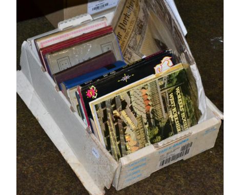
Leeds A collection of works relating to Leeds, it's history, culture and environs including: Grand Theatre, Leeds Programmes and Book of Words 1928-9. 8vo, blue cloth. An interesting collection of theatrical ephemera from the year's season. A fascinating guide to the theatre of the day, as well as the trades and shops of Leeds which advertised. Geographia Plan of the City of Leeds. Geographia, [c.1930s as showing the new postal districts]. Coloured in outline, in paper wrappers, with street directory. Frith Series Leeds. Twenty photographic plates in red cloth boards. [c.1900] with White, Leeds Directory, 1857-8; Bogg, Round About Leeds, 1904; and Dodgson, Guide to the Borough of Leeds, 1879 (with folding map) and a number of others on Leeds landmarks, architecture and more including The Yorkshire Post Tercentenary Supplement [20]

Lot 287
George Frederick Raymond "A New Universal and Impartial History of England" with a folding map by Thomas Bowen, inscribed in script with the previous owners from 1801 and rebound in full calf Condition Report & Further Details Click here for further images, condition, auction times & delivery costs


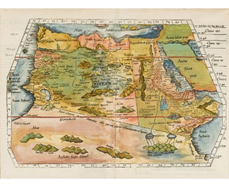
Lot 1
Africa.- Fries (Lorenz) Tabula IIII Aphricae, Ptolemaic map of northern Africa on a trapezoidal projection, with part of Saudi Arabia, showing the source of the Nile depicted above the "Mons Lune", and with a seated Christian king below Ethiopia, who is said to be Prester John, the mythical Christian patriarch and king, woodcut with early hand-colouring, 395 x 530 mm. (15 1/2 x 20 7/8 in), central vertical fold, Latin text on verso with woodcut border and ornamentation attributed to Hans Holbein, tipped at edges onto mount, minor handling crease and light browning at extremities, unframed, Lyon, 1535.

Lot 10
Africa.- Morocco.- Oretlius (Abraham) Fessae, et Marocchi Regna Africae Celeberr, map covering north-western Africa, with the Canaries and Madeira, and an inset map of the Congo, after Filippo Pigafetta's map of the kingdom, engraving with fine early hand-colouring, on laid paper without watermark, platemark 387 x 498 mm. (15 1/4 x 19 5/8 in), sheet 397 x 522 mm. (15 5/8 x 20 5/8 in), central vertical fold with support verso, minor surface dirt and handling creases, unframed, [1598].Literature:VdB 177

Lot 101
India.- Rennell (Major James) Five maps from Rennell's 'Bengal Atlas', including 'The River Ganges from Patna to Surdah with Plans of Patna and Monghir', 'The River Ganges from Allahabad to Patna with Plans of Allahabad and Chunargur', 'The Jungleterry District; with the adjacent Provinces of Birboom, Rajemal, Boglipour &c.', and 'The Conquered Provinces of the south of Bahar; containing Ramgur, Palamow, & Chuta-Nagpour', the 'Map of the Cossimbuzar Island', engravings on thick laid paper with indistinct text-based watermarks, various sizes, 485 x 665 mm. (19 1/8 x 26 1/4 in) and smaller, vertical creases as issued, otherwise occasional very minor surface dirt, all unframed, 1779-1780 (5).

Lot 102
India & Sri Lanka.- Coronelli (Vincenzo Maria) Penisola dell' Indo di qua del Gange, e l'Isola di Ceilan nell' Indie Orientali Descritta..., map of India below the Tropic of Cancer, with inset maps of Sri Lanka and Trincomalee harbour, engraving with hand-colouring on laid paper with watermark of three crescents, platemark 460 x 615 mm. (18 1/8 x 24 1/4 in), sheet 495 x 660 mm. (19 1/2 x 26 in), central vertical fold with some minor repairs and small worm holes in the upper margin, minor surface dirt and light browning, unframed, 1696.
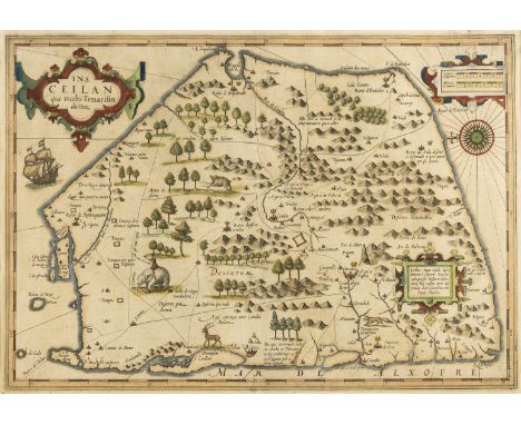
Lot 105
Sri Lanka.- Mercator (Gerard) and Jodicus Hondius. Ceilan Quae Incolis Tenarisin Dicitur, early map of Sri Lanka shown as a five-sided shape, with north orientated to the west, strapwork title cartouche in the upper left, with a sailing ship, elephant, and decorative compass rose, engraving with hand-colouring on laid paper with indistinct watermark, platemark 350 x 502 mm. (13 3/4 x 19 3/4 in), sheet 440 x 550 mm. (17 1/4 x 21 3/4 in), Latin text verso, under glass, some minor surface dirt and light browning, small repair visible verso to upper left corner, well outside the map, framed, [circa 1606 and later].

Lot 106
Sri Lanka.- Keulen (Gerard van) Pascaert van't Eylandt Ceylon, Voordefen Taprobana; by de Inwoonders Genaemt Lankaun, large detailed sea chart of the island with north orientated to the right, ornate title decorated with a camel and figures in regional costume in the lower right corner, several sailing ships and a sea monster, and large elephant inland, engraving with hand-colouring and heightened with gold, platemark 515 x 595 mm. (20 1/4 x 23 1/2 in), good margins, under glass, central vertical fold as issued, some minor surface dirt and browning, framed, [circa 1680 and later].⁂ An impressive and particularly fine map of Sri Lanka.
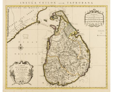
Lot 107
Sri Lanka.- De L'Isle (Guillaume) Carte de l'Isle de Ceylan Dressee sur les Observations de Mrs. de l'Academie Royale des Sciences, large map of the island with part of India in the upper left corner, decorative title and separate scale cartouche, engraving without outline hand-colouring on laid paper without watermark, platemark 500 x 580 mm. (19 3/4 x 22 3/4 in), sheet 565 x 670 mm. (22 1/4 x 26 3/8 in), central vertical fold as issued, minor spotting mainly in margins, some light surface dirt, unframed, Covens and Mortier, [1730].

Lot 108
Sri Lanka.- Dawson (A.H.G, Surveyor General) The Agricultural Map of Ceylon, four sheets on a scale of 4 miles to an inch, with detailed colour-coded references to the nature of agricultural production on the island, notably coconuts, tea, rubber and cacao, and numerous other agricultural and geographic specifics, lithographs printed in colour, various sizes, largest 1040 x 630 mm. (41 x 24 3/4 in), numerous repaired tears and splits, some with restored loss, minor surface dirt and browning, each with blue linen edges, unframed, Survey Dept. Ceylon, 1927 (4).

Lot 112
Ireland.- Speed (John) The Province of Connaugh with the Citie of Galwaye Described, early map of the province of Connacht including the counties of Galway, Clare, Sligo, Mayo, Roscommon, with an inset plan of the fortified city of Galway, with large strapwork cartouche surmounted with coat of arms of Charles I, engraving on laid paper with watermark of indistinct armorial device, sheet 415 x 530 mm. (16 1/4 x 20 7/8 in), central vertical fold with splitting to upper and lower sections, some loss to margins at centre right and left, minor loss in the patterned border, surface dirt and handling creases, unframed, Sudbury and Humble, 1610.

Lot 118
Middle East.- Ortelius (Abraham) Persici sive Sophorum Regni Typus, Persia from the Caspian Sea to the Red Sea, strapwork title cartouche lower right, engraved map with some outline hand-colouring, a good impression on laid paper with watermark of crossed arrows [see Briquet 6283], platemark 350 x 495 mm. (13 3/4 x 19 1/2 in). sheet 385 x 550 mm. (15 1/4 x 21 3/4 in), Latin text verso with page number 49, central vertical fold with minor repair to splitting at lower edge, faint crease in lower left margin, unframed, [1571].Literature:VdB 167

Lot 119
Middle East.- Homann Heirs (publisher) Imperium Turcicum in Europa, Asia et Africa Regiones Proprias, Tributarias, Clientelares ..., detailed map centred on the Levant and Arabian Peninsula, with the Mediterranean, southern Europe and the Baltics, and part of Iran in the east, with large decorative cartouche in the lower left, engraving with hand-colouring on laid paper with text-based watermark, platemark 503 x 610 mm. (19 3/4 x 24 in), sheet 535 x 630 mm. (21 x 24 3/4 in), central vertical fold with some small repairs, handling creases, and minor surface dirt, unframed, 1737.
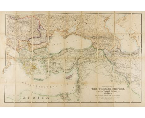
Lot 120
Middle East.- Stanford (Edward) Stanford's Map of Part of The Turkish Empire, with Lower Egypt, The New Balkan Provinces and Greece, large folding map, lithograph partly printed in colour, 1180 x 815 mm. (46 1/2 x 32 in), dissected and mounted on linen, folding with printer's yellow endpaper into original boards with yellow label, slightly worn, 8vo, 1885.

Lot 121
Middle East.- Ortelius (Abraham) Geographia Sacra, map of the ancient Biblical world including southern Europe, northern Africa and the Middle East, with inset map of the world in the lower centre, a strapwork cartouche to the left and right, and with decorative title cartouche upper centre, engraving with extensive hand-colouring on laid paper with watermark of armorial device, platemark 355 x 480 mm. (14 x 18 7/8 in), sheet 450 x 560 mm. (17 3/4 x 22 in), Latin text verso, central vertical fold, several expertly repaired areas of small loss, mainly to margins, small nicks and tears, unframed, [1609-1612].Literature:VdB 179

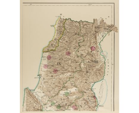
Lot 123
Near East.- Conder (Lt. C.R.) and Lt. H.H. Kitchener. Map of Palestine in 26 Sheets from Surveys conducted for the Committee of the Palestine Exploration Fund during the years 1872-1877, subscriber's copy with printed number 120, title with ink signature of Chairman James Glaisher, hand-coloured key map and 26 photozincographed map sheets with some hand-colouring, each sheet approx. 590 x 680 mm. (23 1/4 x 26 3/4 in), title and key map with small tears and frayed at edges, occasional spotting and with some surface dirt, loose as issued in original half-morocco, spine split, boards detached, worn, folio, printed by the Ordnance Survey Office, 1880.
Lot 124
Near East.- Conder (Lt. C.R.) and Lt. H.H. Kitchener. Four "Special Edition" maps of Western Palestine, from Surveys conducted for the Committee of the Palestine Exploration Fund, including the maps 'Illustrating The New Testament, also The Talmud and Josephus', 'Illustrating The Old Testament, the Apocrypha and Josephus', 'Illustrating the Divisions of The Natural Drainage and the Mountain Ranges', and a map of Western Palestine 'Reduced from the one inch map. Scale 3/8 inch to one mile', each separate map comprises of six photozincographed sheets with some hand-colouring, each sheet approx. 510 x 610 mm. (20 1/8 x 24 in), occasional nicks and tears to edges, some spotting and browning, all four presented in original paper wrappers with printed title to upper cover, two with spines completely split, nicks and tears, worn, oblong folios, each 'Engraved and printed for the Committee at Stanford's Geographical Establishment', 1881-1882; together with an incomplete 'A Map of Palestine [...] Scale 3/8 inch to one mile', 21 sheets only, photozincographed sheets with some hand-colouring, each sheet approx. 510 x 610 mm. (20 1/8 x 24 in), some with severe creasing, surface dirt and browning, loose in original paper wrappers, torn with loss and spine split, oblong folio, 1890 (5).

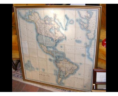
Lot 125
North Atlantic.- Bowen (Emanuel) A Map of the King of Great Britain's Dominions in Europe, Africa, and America, map drawn on a circular projection showing the extent of the British Empire in the 18th century, showing from the Arctic Circle down to the equator, centred on the Atlantic Ocean with parts of North and South America, including the Cuba and the Caribbean islands, and Great Britain, and parts of Europe, Africa and Cape Verde, engraving with outline hand-colouring, on thin laid paper without watermark, sheet 395 x 470 mm. (15 1/2 x 18 1/2 in), two parallel vertical folds, probably as issued, another light vertical crease, otherwise a clean copy with minor spotting and surface dirt, unframed, [circa 1740].⁂ Scarce.

Lot 127
Pakistan, Afghanistan & Northern India.- Jansson (Jan) Magni Mogolis Imperium, map of the Empire of the Great Mogul in northern India including the region from Iran to Burma, decorated with title in the upper left corner, and with numerous elephants, big cats, and a camel, engraving with some hand-colouring on laid paper, platemark 370 x 495 mm. (14 1/2 x 19 1/2 in), good margins, central vertical fold as issued, some minor spotting and browning, framed and glazed, [circa 1650 and later].
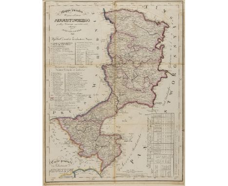
Lot 129
Poland.- Kolberg (Juliusz) Mappa jeneralna Wojewodztwa Augustowskiego, detailed map of the region surrounding Augustow in north eastern Poland from "Atlas Krolestwa Polskiego" or the Atlas of the Polish Kingdom, lithograph with hand-colouring, sheet 570 x 435 mm. (22 1/2 x 17 1/8 in), the map is mounted on linen and has been carefully cut into sections and re-affixed in several places, several folds, some minor loss, surface dirt and minor browning, unframed, 1826.⁂ Rare.

Lot 130
Portugal.- Jode (Gerard de) Portugalliae Quae Olim Lusitania Vernando Alvaro Secco Autore Recens Descriptio, detailed map of Portugal, orientated to the west, numerous galleons, galleys and sea monsters, from de Jode's 'Speculum Orbis Terrarum', engraving, an excellent clean impression on laid paper with indistinct armorial watermark, platemark 317 x 522 mm. (12 1/2 x 20 1/2 in), sheet 402 x 555 mm. (15 7/8 x 21 3/4 in), Latin text verso, central vertical fold as issued, unframed, 1578. ⁂ Rare.

Lot 133
Russia.- Homann Heirs (pubishers) Imperii Russici et Tartariae Universae tam majoris et Asiaticae quam minoris et Europae Tabula..., detailed map covering all of the region from the Baltic Sea across Siberia and south into China including Korea, Japan and Formosa, with three decorative cartouches, engraving with some outline hand-colouring, laid paper without watermark, platemark 492 x 562 mm. (19 3/8 x 22 1/8 in), sheet 514 x 620 mm. (20 1/4 x 24 1/2 in), contemporary ink numbering '46' verso, central vertical fold, reinforced verso, small nick to lower edge, otherwise some handling creases, unframed, 1739.
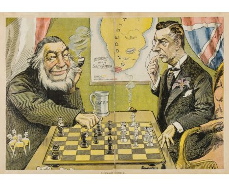
Lot 134
South Africa.- Rhodesia.- Anonymous (circa 1890s) Check-mate, Rhode's Map of South Africa, political cartoon with Joseph Chamberlain in dire straits during talks with Paul Kruger of South Africa, map behind, lithograph printed in colours, sheet 290 x 420 mm. (11 1/2 x 16 1/2 in), central vertical fold with splitting reinforced verso, minor surface dirt and light browning, unframed, [1896].

Lot 135
South America.- Cary (John) A New Map of South America from the Latest Authorities, large detailed map including part of the West Indies, with the Falkland's Islands in the south, from Cary's 'New Universal Atlas', engraving with hand-colouring, on two sheets of wove paper conjoined, one watermarked with date '1806', total approx. 960 x 680 mm. (37 3/4 x 26 3/4 in), central and vertical folds with some minor splitting, one small tear in the map at the centre left, minor spotting and offsetting, faint handling creases, unframed, 1807.
![NO RESERVE South Pole.- Coronelli (Vincenzo Maria) [Globe Gore] Fernando Magaglianes Poco Contento del Re di Portogallo suo S](https://cdn.globalauctionplatform.com/b079d8b6-c9f1-44ba-a4d1-a96600ab5dd9/11fc348e-b100-4cf3-a6f2-e1e55a15a36b/468x382.jpg)
Lot 136
NO RESERVE South Pole.- Coronelli (Vincenzo Maria) [Globe Gore] Fernando Magaglianes Poco Contento del Re di Portogallo suo Signore..., unusual map completely lacking cartographic detail, but instead Coronelli records notes in each segment of longitude concerning what was known and speculation, with decorative vignette and cartouche featuring description of Magellan's circumnavigation, engraving on thick laid paper without watermark, platemark diameter 375 mm. (14 3/4 in). sheet 710 x 500 mm. (28 x 19 3/4 in), full margins, central vertical fold, minor handling creases and some surface dirt, unframed, [1690].

Lot 139
Switzerland.- Ortelius (Abraham) Lacus Lemani Vicinorumq. Locorum Nova et Accurata Descriptio, map covering the region surrounding Lake Geneva, including a small plan of the city of Geneva, part of Burgundy and the French Alps in the lower left, with decorative title cartouche in the lower right corner, and ships and a sea creature in the lake, engraved map with early hand-colouring, on laid paper with watermark of a musical horn, platemark 370 x 510 mm. (14 1/2 x 20 in), Latin text verso, central vertical fold, minor surface dirt, unframed, [1609-1612].Literature:VdB 55

Lot 14
Algeria.- Ottens (Reiner & Joshua) Nouvelle Carte du Roiaume d'Alger, Divisee en Toutes ses Provinces ..., map of northern Africa with inset map of the bay of Algiers, engraving on laid paper without watermark, platemark 445 x 555 mm. (17 1/2 x 21 3/4 in), sheet 540 x 635 mm. (21 1/4 x 25 in), central vertical fold with minor splitting, some surface dirt, other minor handling creases and light folds, nicks and tears to extremities, unframed, [1740]; together with a Dutch printing of Emanuel Bowen's two-part map of the Barbary coast, platemark 350 x 430 mm. (13 3/4 x 16 7/8 in), 1781 (2).

Lot 140
Switzerland.- Ortelius (Abraham) Helvetiae Descriptio, Aegidio Tschudo Auct., early map of Switzerland with north orientated to the bottom of the chart, engraving with hand-colouring, on laid paper with indistinct watermark, platemark 345 x 455 mm. (13 1/2 x 17 7/8 in), sheet 460 x 570 mm. (18 1/8 x 22 1/2 in), French text verso, central vertical fold as issued with some splitting to lower section, minor browning and surface dirt, unframed, [circa 1571 but later].

Lot 142
West Indies & Gulf of Mexico.- Bowen (Emanuel) A group of 5 maps of the West Indies from Bowen's 'A Complete System of Geography ...', includes: An Accurate Map of the Island of Barbadoes; A New and Accurate Map of the Island of Jamaica; A New & Accurate Map of Bermudas or Sommers Islands; An Accurate Map of the West Indies; Particular Draughts and Plans of some of the Principal Towns and Harbours [...] in Americas and West Indies, engravings with all but one with hand-colouring, each sheet approx. 410 x 455 mm. (16 1/8 x 17 7/8 in), all with central vertical folds as issued, some occasional spotting and browning, light damp-stains, the the Bermudas map with loss and repaired tear to the lower left corner, unframed, [1747] (5).

Lot 143
World.- Robert de Vaugondy (publisher) Mappe Monde suivant la projection des cartes rediutes, world map on Mercator's projection, with most of the northwest in North America remaining blank except for a notation and hint of the possible Northwest Passage and discoveries of Admiral de Fonte, engraving with some hand-colouring on laid paper with indistinct watermark, platemark 258 x 415 mm. (10 1/8 x 16 1/4 in), sheet 287 x 420 mm. (11 1/4 x 16 1/2 in), central vertical fold, some small loss to lower margin, but well outside map, minor spotting and browning, unframed, 1778.

Lot 144
World.- Chamouin (Jean Baptiste Marie) Mappe-Mondes sur Diverses Projections, double hemisphere world map centered on Sumatra, with 5 further smaller projections, with allegorical vignette and title in the upper centre, engraving with some outline hand-colouring on laid paper with watermark of initials 'F D' with heart in-between the letters, sheet 334 x 495 mm. (13 1/8 x 19 1/2 in), central vertical fold, minor spotting and surface dirt, unframed, [circa 1805].
![World.- World War.- Petersen (C.C.) Map of the World War Fronts [recto]; World map centred on the Pacific Ocean [verso], fift](https://cdn.globalauctionplatform.com/b079d8b6-c9f1-44ba-a4d1-a96600ab5dd9/26b48168-6acd-4b58-88f9-fb19fea45b6f/468x382.jpg)
Lot 145
World.- World War.- Petersen (C.C.) Map of the World War Fronts [recto]; World map centred on the Pacific Ocean [verso], fifth edition of "dated events" illustrating dates, names and places of military encounters during the second World War, lithograph, recto printed in colours, sheet 510 x 670 mm. (20 1/8 x 26 1/4 in), old folds, some repairs to minor splitting and small nicks at extremities, unframed, Toronto, 1943.

Lot 146
Ancient World.- Ortelius (Abraham) Aevi Veteris, Typus Geographicus, map illustrating the ancient world, showing the regions of the world that were known, on a large oval projection showing the relative size of the now-known world, with decorative border featuring small inset maps of Europe, Asia, America, and Africa in each corner, engraving, platemark 315 x 445 mm. (12 1/2 x 17 1/2 in), sheet 395 x 535 mm. (15 1/2 x 21 in), good margins, with Latin text verso, central vertical fold, careful repair to skimming of sheet in lower right margin, minor surface dirt, unframed, [Antwerp, 1590].Literature:VdB 186

Lot 148
Britain.- Cary (John, publisher) Cary's New Map of England and Wales with Part of Scotland, complete with all 81 sheets, engraved map hand-coloured in outline, divided into three sections, each approx. 750 x 1800 mm. (29 1/2 x 7- 3/4 in), dissected and mounted on linen, some offsetting, spotting and browning with damp-stains visible, edged with green silk, folding into contemporary slipcase, very worn and partially disbound, lacking lid, 4to, John Cary, 1794.

Lot 150
British Isles.- Ortelius (Abraham) Angliae, Scotiae, et Hiberniae, sive Britannicar: Insularum Descriptio, map of the British Isles oriented with north to the right, with the north of France to the left, two ornate strap-work cartouches, the royal coat of arms, and with five sailing ships, engraving with hand-colouring, platemark 345 x 505 mm. (13 1/2 x 19 7/8 in), sheet 400 x 560 mm. (15 3/4 x 22 in), French text verso, central vertical fold with minor repairs to splitting, some small repairs to borders, light surface dirt and browning, unframed, [Antwerp, 1581]. Literature:VdB 16.2⁂ The present map predates the convention of depicting the British Isles with north to the top.
Lot 153
England.- A group of 16 Ordnance Survey maps, including a Col. Mudge map of Kent showing Whitstable, Ramsgate and Dover, 4 Col. Colby maps sold by Letts, Son & Co. of Essex, Kent, Berkshire, and Hampshire, and others of Essex, Rochester, Surrey and Worcester, engraved and lithographed maps, some with outline hand-colouring, various sizes, largest approx. 670 x 1000 mm. (26 1/2 x 39 1/2 in), all dissected and mounted on linen, the majority with original marbled ends and printed labels of publishers, occasional surface dirt, spotting and browning, without slip-cases, mainly mid-to-late 19th century (16).

Lot 154
England.- Cary (John) A New Map of Warwickshire; A New Map of Worcestershire; A New Map of Lancashire, three county maps, engravings with hand-colouring, each sheet approx. 640 x 530 mm. (25 1/4 x 20 7/8 in), or the reverse, some light offsetting and minor spotting and browning, unframed, 1801-1811 (3).

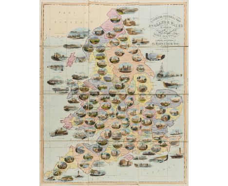
Lot 156
England & Wales.- Games.- Spooner (William) Spooner's Pictorial Map of England & Wales, 'Arranged as An Amusing and Instructive Game for Youth, Illustrated with upwards of One Hundred and Twenty Views', lithograph with hand-colouring, 615 x 495 mm. (24 1/4 x 19 1/2 in), dissected and mounted on linen, some peeling away from linen, minor surface dirt and handling creases, folding with green endpaper into original boards, original printed label to upper cover, worn with some rubbing, 8vo, 1844.

Lot 158
England.- East Coast.- Jaillot (Alexis-Hubert) Carte de l'Entree de la Tamise avec les Bancs, Passes, Isles et Costes Comprises Entre Sandwich et Clay, large chart of the eastern coastline of England with north orientated to the east, including Norfolk, Suffolk, Essex, and Kent, showing the Isle of Thanet to Sheringham, with an inset map of the River Thames from its estuary to London, engraving with outline hand-colouring on thick laid paper with watermark of an eagle, platemark 460 x 895 mm. (18 1/8 x 35 1/4 in), sheet 645 x 945 mm. (25 1/2 x 37 1/4 in), central vertical fold as issued, minor spotting in upper left margin, unframed, [1693 and later].
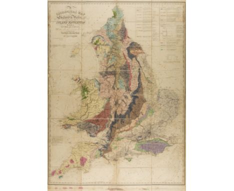
Lot 159
Geological map.- Walker (John & Charles, publishers) A Geological Map of England and Wales, First edition, second state, 'showing also the Inland Navigation by means of Rivers & Canals, with their Elevation in feet above the Sea', large title in the upper left quadrant, engraving with hand-colouring, 1285 x 1000 mm. (50 1/2 x 39 1/4 in), dissected and mounted on linen with green endpapers and yellow printed collector's label of Mr. Ja[me]s Bromilow, minor spotting and offsetting, folding into original dark green moiré silk slip-case, with black morocco label with gilt lettering, rubbed and scuffed, 8vo, 1835.
-
109182 item(s)/page