We found 108737 price guide item(s) matching your search

Refine your search

Year

Filter by Price Range
  • List
  • Grid
  • 108737 item(s)
    /page

Lot 812

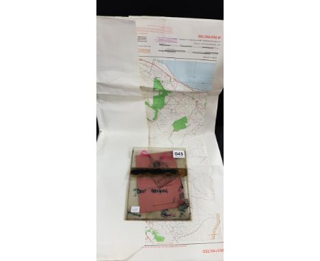
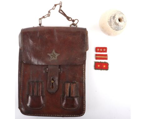
WW2 Japanese Type 4 Ceramic Grenade, being a very good example of the late war produced grenade as issued to the Japanese fighting forces on Iwo Jima and Okinawa. The spherical body with a bottle neck. Generally good condition. Accompanied by a WW2 Japanese officers brown leather map case and three items of Japanese cloth rank insignia. The map case with some stitching faults. (5 items)

Lot 773

MISCELLANEOUS PICTURES AND PRINTS, INCLUDING THE SOUTHWEST PROSPECT OF LIVERPOOL, REPRODUCTION MAP OF ANGLESEY Condition report  

Lot 42

Mixed pictures to include a Russel Flint print, a 19th century map of Shropshire and others together with an oval wall hanging mirror

Lot 84

John Speed, a hand coloured map of Denbighshire, dated 1610, by John Sudbury and George Humble, 37cm by 49cm, framed and glazed and Robert Morden, Britannia Romana, hand coloured, 34cm by 41cm, framed (2)

Lot 378

'WILTONIA' AN ENGRAVED MAP OF WILTSHIRE BY CHRISTOPHER SAXTON (C.1540 - C.1610) engraved by Remigius Hogenbergius, hand-coloured, with a strap-work and figural title panel, dated '1576', with the Royal Coat of Arms for Elizabeth I and the coat of arms for Thomas Seckford, published in '1579', in a later gilt moulded and glazed frame 40.5 x 47cm Catalogue Note: This is the first published map of Wiltshire.

Lot 379

'WILTONIAE' AN ENGRAVED MAP OF WILTSHIRE BY CHRISTOPHER SAXTON (C.1540 - C.1610) engraved by Remigius Hogenbergius, hand-coloured, with a strap-work and figural title panel, dated '1642', with the Royal Coat of Arms for Charles I and the coat of arms for Thomas Seckford, in a later bird's eye maple moulded and glazed frame 42 x 47cm

Lot 380

'WILSHIRE' AN ENGRAVED MAP BY JOHN SPEED (1552-1629) a hand-coloured map of Wiltshire, with a plan of Salisbury and a view of Stonehenge, sold by Thomas Bassett and Richard Chiswell, with English text to verso, in a double sided, moulded gilt and glazed frame 39 x 52cm

Lot 383

'GLOCESTERSHIRE' AN ENGRAVED MAP BY JOHN SPEED (1552-1629) a hand-coloured map of Gloucestershire, with plans of Gloucester and Bristow, sold by John Sudbury and George Humble, with English text to verso, in a double sided, moulded gilt and glazed frame, together with a later map of 'Gloucestershire' engraved by J. Bingley (2) 39.5 x 52.7cm

Lot 384

'CORNWALL' AN ENGRAVED MAP BY JOHN SPEED (1552-1629) a hand-coloured engraved map with an inset view of Launceston, English text to verso, dated '1610', in a later bird's eye maple double-sided glazed frame 42 x 52cm

Lot 385

'THE KINGDOME OF SCOTLAND' AN ENGRAVED MAP BY JOHN SPEED (1552-1629) hand-coloured, with an inset view of the Isles of Orkney, English text to verso, dated '1610', in a later bird's eye maple double-sided glazed frame 42.7 x 54cm

Lot 387

'REGIONIS QUAE EST CIRCA LONDINUM' AN ENGRAVED MAP OF LONDON AFTER JOHANN HOMANN (GERMAN 1664-1724) published by Homann Heirs and dated '1741', hand-coloured, the lower section with a bird's eye view of London, Westminster and the Thames, in a later gilt moulded and glazed frame 52 x 59cm

Lot 389

'MIDDLESEX' AN ENGRAVED MAP BY RICHARD WILLIAM SEALE (1703-1762) hand-coloured, depicting the county and the city of London, with city coat of arms and the coat of arms of all of the 'Free Companies of London', in a later moulded gilt and glazed frame 53.2 x 74.5cm

Lot 390

'LES ISLES BRITANNIQUES' AN ENGRAVED MAP BY JAN BAREND ELWE (DUTCH 1777-1815) hand-coloured, with an inset view of the Isles of Orkney, Shetland Islands and Faroe Islands, in a later glazed giltwood frame 61 x 49.5cm

Lot 391

'BRITTANIA' AN ENGRAVED MAP BY JOHANNES BLAEU (DUTCH 1596-1673) hand-coloured, with fourteen cartouches depicting Saxon figures and events, with Latin text to verso, in a moulded gilt double sided glazed frame 43 x 54.5cm

Lot 392

'PARTE MERIDIONALE DEL REGNO D'INGHILTERRA' AN ENGRAVED MAP BY VINCENZO CORONELLI (ITALIAN 1650-1718) hand-coloured, depicting southern England & Wales, with Latin text to verso, in a double sided moulded gilt and glazed frame 46.6 x 62.5cm

Lot 394

'ABYSSINORUM' AN ENGRAVED MAP OF ABYSSINIA PUBLISHED BY JOHANN BUSSEMACHER (GERMAN FL.1580-1613) AFTER M. QUAD dated '1600' and hand-coloured, with a cartouche dedicated to the legendary Prester John, with the map showing enthroned in present day Sudan, in a later moulded burr-walnut glazed frame 22.3 x 29cm

Lot 395

'L'ASIA DIVISA NE'SUOI PRINCIPALI STATI' AN ENGRAVED MAP BY ANTONIO ZATTA (ITALIAN FL. 1757-1797) hand-coloured and dated 'Venezia 1777', in a later gilt moulded, glazed frame 31.4 x 41.5cm

Lot 396

A MODERN MAP OF THE 'CAMINO DE SANTIAGO' IN 17TH CENTURY STYLE BY DANIEL DERVEAUX (FRENCH D.2010), PUBLISHED IN FRANCE IN 1975; imitating the old style of engraved maps but printed in colour on cardboard, with the date '1648' to make it look period, the map shows pilgrimage routes and associated sanctuaries from France to Santiago de Compostela in Spain as imagined by Daniel Derveaux and not corresponding with the factual 17th century paths, in a glazed giltwood frame 58.5 x 42.5cm

Lot 397

'NOVA ORBIS TABULA IN LUCEM EDITA' AN ENGRAVED MAP OF THE WORLD BY FREDERICK DE WIT (DUTCH 1630-1706) ,C.1670 second state, hand-coloured, depicting the two hemispheres, with California depicted as an island with additional hemispheres of the north and south poles, the spandrels with allegorical vignettes representing the four seasons, elements and the signs of the zodiac, in a later moulded gilt and glazed frame 47 x 56cm

Lot 45

UDR/RUC OPERATIONS MAP WITH POINTER AND MANUAL - QUITE RARE - CENTERED AROUND CRASSMAGLEN

Lot 1853

A nest of three campaign style brass bound mahogany occasional tables, with inset map tops, the larger 64cm wide x 46cm high.

Lot 92

A framed J. Blaeu limited edition 1645 map of Cambridgeshire with hand colours, 17/100.

Lot 96

A black and gilt hand coloured map of venice

Lot 223

* * Nirvana : Landscape with Windmill, oil on canvas, signed, 30 x 40 cm, together with a colour facsimile map of Cyprus and a framed colour abstract print, all parts framed. (3)

Lot 702

A camel stool and a coffee table depicting a map of the world

Lot 376

After John Speed, Buckingham both Shire and Shire Town described, hand coloured map, 1610, 38cm x 50cm.

Lot 379

John Speed, Northampton Shire, hand-coloured county map, 39cm x 51cm; another copy, Speed's Map of Bedford Shire; Robert Morden's Huntingdon Shire; and other maps, mostly of regional interest.

Lot 404

Contemporary stained beechwood footstool, London map upholstery, cabriole legs, 47cm x 34cm.

Lot 170

University of London printed map of the moon, ' Celestial Objects for Common Telescopes ' by Webb, canvas bound volume ' Optimal Design and Lens Computation ' by K.J. Johnson and ' The Jungle Book ' by Rudyard Kipling

Lot 1332

17th Century hand coloured map of Calabria Ultra by Willem Blaeu, published 1646, in a gilt double glazed frame, with text verso, 15.5ins x 20ins

Lot 1381

Small hand coloured map of Shropshire, dated 1830, 10ins x 8ins, oak framed

Lot 152A

Quantity of stamps together with a framed facsimile print, map of Putney

Lot 469

Large quantity of framed prints to include a map of Kent, framed embroideries and tapestries, etc (3 boxes) 

Lot 528

"Saxton's Map of Oxfordshire, Buckinghamshire and Berkshire 1574", printed by Taylor Ltd 1968, 40.5cm x 38.5cm

Lot 145

1 bottle Berry Bros & Rudd Grande Champagne des Heritiers Naturel Cognac 1906 Cognac Shipped and bottled in 1967. Map of the Charente on the label. Blue plastic capsule. Level 4.5cms This lot is subject to VAT on the hammer price

Lot 496

A large scroll map of England and Wales. 104cm x 90cm.

Lot 14

Samuell Pepys, coloured map of Harwich

Lot 628

A Robert Morden map of Cornwall and a sporting print

Lot 381

TWO BOXES AND LOOSE PRINTS etc, to include a signed David Dipnall print 'Memories of Summer Days' framed, approximate size 46cm x 53cm, signed Rex Preston framed print, signed Donald Ayres print, John Player 'Cricketeers 1938' full set - framed, Ken Arrowsmith watercolour of a rural scene, together with a quantity of framed prints and photographs on a variety of subjects - flowers, impressionists etc and a Robert Morden map of Nottinghamshire, largest framed print approximately 61cm x 94cm including frame

Lot 388

PAINTINGS AND PRINTS ETC, to include 'Ted Battersea Saint Denoeux, France', a watercolour of a French village, approximate size 51cm x 71cm, with a pen and wash sketch of the same scene, approximate size 24cm x 33cm, watercolour of a church by R.W.Bardsmore, photographic print of Trinity College Cambridge, Rugby 1st XI, dated 1910, together with assorted prints, box canvas prints, photographs and maritime map 'Islay to Ardnamurchan'

Lot 89

A framed 3D map of the Lake District

Lot 695

A ship's log from HMS Hibernia, 1849 by Admiral Augustus Phillimore with hand drawn charts and sea map of Southern Spain

Lot 44

Hand Coloured Map of Selkirkshire, Marked to the base of the Map, Published by John Thomson & Co Edinburgh 1824, 68.5cm x 52.3cm, Also with two other Hand Coloured Maps of Selkirk, 19.5cm x 14.5cm, and 18cm x 22.5cm, (3)

Lot 606

Quantity of Silver Plate including Wine Cooler, Tankards, plus a Few Silver Teaspoons, Map Measure and a Cutlery Tray

Lot 624

Two Oak Framed Antique Hand Coloured Map Engravings of Gloucestershire together with 1720 Emmanuel Bowen Map of South Wales and Three Further Antique Map Engravings, largest 26cms x 20cms

Lot 948

ROBERT MORDEN (1650-1703) British, Map of Huntingdonshire, framed and glazed. 42 x 36 cm.

Lot 949

A John Speed map of Herefordshire, dated 1610; together with two other maps of Herefordshire. The former 53 x 40 cm.

Lot 353

A 20th century hand coloured map of Huntingtonshire after Robert Morden, print, 37 x 42cm

Lot 376

A framed Chapman and Hall antique map engraving by Sidney Hall of Wiltshire.

Lot 1063

B Cole - plan of Bishopsgate Ward, London, colour engraving circa 1755, 24x38cm, one other of the period being Billingsgate and Bridgewards, J Cary, engraved County Map of Essex, 15x10cm, and after Bowen - Ipswich Roads, engraved strip map, 19x12cm, all unframed (4)

Lot 2083

A quantity of pictures to include an Oil on canvas of Bromley Market House, framed Map of Worcester, a Margaret Barrett horse racing Print and a Watercolour of flowers signed J.G. '98, etc.

Lot 2183

A framed H.D.W. Architect Painting depicting "The proposed Office Development, Cardiff", 28'' x 20'' (glass a/f) and a framed Print of The Cambrian Centre, Newport, 24'' x 19'' and a framed Print of Map of Monmouthshire.

Lot 1123

A framed and mounted Map of India, a framed and mounted Map of Gloucestershire and Gower the treacherous coast.

Lot 1141

A Map on canvas of rivers and roads by L. Stockdale, 1794 and a road map of Montgomery.

Lot 1192

A map of The Isle of Wight, 10 1/2'' x 8''.

Lot 224

LOT OF STAMPS AND POSTCARDS, contained across six folders, along with a map of Burma and other related ephemera

Lot 70

MAP OF THE ESTUARY OF THE CLYDE, mounted, framed and under glass, along with two 20th century samplers, and four printing plates

Lot 1011

Church in Sheffield, After Thomas Harris, black and white print, 37 x 55cm; Buckingham Palace and floral prints; 1967 printed map of Yorkshire. (4)

Lot 292

SPEED (JOHN), PERSIA, THE KINGDOM OF PERSIA & THE CHIEF CITTIES & HABITES, hand coloured double paged engraved map, four views in upper border, eight costume figures to side borders, English text verso, 1626 or later, 39 x 51cms

Loading...Loading...
  • 108737 item(s)
    /page

Recently Viewed Lots