We found 109198 price guide item(s) matching your search
There are 109198 lots that match your search criteria. Subscribe now to get instant access to the full price guide service.
Click here to subscribe- List
- Grid
-
109198 item(s)/page


Lot 687
A Queen Anne walnut cabinet on chest, circa 1700, with moulded cornice above two cupboard doors concealing an arrangement of ten small drawers, on a chest of two short and two long graduated drawers on bun feet, 167.5cm x 109cm/see illustration Condition Report: Colour and patina good, small area of beading missing from interior, each door has split vertically through the centre, feet old but probably replacements. Small dent in centre of left hand door, carcass split to both sides of top, later lock to map drawer .Handles, locks and escutcheon would appear to be original. Slight damage to veneer by hinges and on upper right door. For its age in good condition


Lot 1130
An 18th century Irish hand-drawn book of maps of the Estate of Samuel Ahmuty Esq., in the County of Longford, surveyed in 1790 by John Jonston, full calf (disbound) 53 x 38 cm, to/w a linen-backed folding map of County Longford by William Edgeworth, 1813 (2) Please note: The surname is now known as 'Auchmuty') Condition Report Full calf, 27 maps, some loose, seems to have names of neighbours, not sure about individual tenants Longford map - 129.5 x 117.5 cm


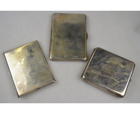
Lot 145
A heavy quality silver cigarette case with engine-turned decoration, Smith & Bartlam, Birmingham 1943, to/w a sterling cigarette case engraved with a map of India and Burma (pre-Partition) and a Japanese example engraved with buildings in a landscape, stamped 'Sterling Silver 950' (3) 15.3 oz


Lot 1007
AN EARLY 20TH CENTURY DE DION-BOUTON ADVERTISING MAP which centres around Châlons-sur-Marne showing surrounding towns and connecting roads within a border advertising 'De Dion-Bouton Moteurs', published by De Dion-Bouton and seemingly printed with a list of various garages selling De Dion-Bouton motor cars and various motor cars, buses and lorries, originally a folding map but now framed and glazed to the front and back, 89cm wide x 79cm high

Lot 425
Iran, Mohammad Reza Pahlavi, proof gold medal for the coronation, SH 1347 (1967), conjoined busts l. of the Shah, Empress and Crown Prince eva, legend around, rev. Imperial Crown and medal placed on map of Iran, within wreath, 38mm., wt. 25.02gms., stamped 900 fine, the images matt against a brilliant surface, minor handling marks and hairlines, virtually as struck

Lot 547
Romania, The Buzau to Marasesti Railway, 60th anniversary, 1941, by Constantin Iotzu (1884-1962), rectangular bronze plaquette with arched top, framed winged figure of speed, legend below, 1881 OCTOMBRIE 1941 - ANI 60 - DE LA PRIMA CALE FERATA BUZAU MARASESTI REALIZATA DE INGINERI ROMANI, rev. railway motif and legend above a map in relief of the railway line, 105 x 56.5mm., in case of issue by the Monetaria Nationala, virtually as struck, rare


Lot 122
Blaeu, (Family) circa 1648 - Caernarvon-shire - A decorative map of the area around North Wales with well-engraved details, the map is embellished with a number of coats of arms with the heraldry, on a sheet with wide margins and a large elephant watermark, with accompanying text verso, 50.5cm x 60cm

Lot 579
Glorious Dozen Luftwaffe Multisigned cover. Unfathomably rare 1975 RAF C42 Dermot Boyle Wing cover. Rare Hans Rossbach "Glorious Dozen" signed cover, numbered 129 of 140 signed by THIRTEEN famous fighter aces of JG-2 Richtofen, the famous Luftwaffe wing. These thirteen aces have an astonishing 1067 combined victories!! Signatures are Adolf Galland, Kurt Buhlingen, Georg-Peter Ader, Hans "Assi" Hahn, Erich Hohagen, Walter Matoni, Julius Meimberg, Erich Rudorffer, Hugo Dahmer, Fritz Karch, Siegfried Lemke, Bruno Stolle and Gunter Seeger. Cover comes with loads of photos, a note signed by Rossbach, and a map of the signatures. Numbered 129 of 140, signed and certified on the reverse. Incredible Good condition

Lot 580
Thirteen WW2 Luftwaffe Multisigned cover RAF Escape from Libya cover. Rare Hans Rossbach variety, a very limited edition numbered 21 of 124. Signed by the Luftwaffe JG27 ‘Glorious Dozen’ THIRTEEN Luftwaffe pilots, Adolf Galland, Eduard Nuemann, Gustav Rodel, Ernst Borgen, Ernst Dullberg, Ludwig Franzisket, Hans-Joachim Heinecke, Werner Schroer, Ferdinand Vogel, Emil Clade, Karl-Heinz Bendert, Friedrich Korner, and Horst Reuter. Also signed by Bernhard Woldenga the senior Kommodore of JG27 who commanded the unit from June 1941 to June 1942 in the Western Desert. All of the signatories (except Korner & Reuter) participated in the Battle of Britain. This cover is certified and then signed to reverse by Hans Rossbach. Cover comes with loads of information, photos, signature map and correspondence from Rossbach. Numbered 21 of 124, signed and certified on the reverse. Good condition


Lot 255
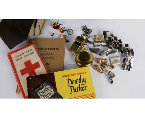
An American USAAF officer's crusher cap, with original USAAF brass badge; together with a military whistle on a chain; a US military pocket compass; an American 1940s Red Cross map of Paris; a 1940s Dorothy Parker Armed Forces short stories booklet; a reproduction instruction book for American Servicemen posted to Britain in 1942; two US officers' ties; an American Army Air Force metal and enamel pin; two sweetheart pins; three other badges; and a quantity of other collectables, (qty).


![MARTIN WALDSEEMULLER THE BRITISH ISLES [TABULA PRIMAE EUROPAE] DOUBLE PAGE PTOLEMAIC MAP FROM THE COSMOGRAPHIAE INTRODUCTIO](https://cdn.globalauctionplatform.com/e5fb85fb-b81c-4b73-b9bf-a50701211495/c1f45d88-35bc-46f7-9c01-8aa553e1ba39/468x382.jpg)
Lot 799
MARTIN WALDSEEMULLER THE BRITISH ISLES [TABULA PRIMAE EUROPAE] DOUBLE PAGE PTOLEMAIC MAP FROM THE COSMOGRAPHIAE INTRODUCTIO 1540, 34 x 44cm, unframed ++In apparently very good condition as when supplied by the trade to the late owner around 30 years ago, the map hinged to card window mount, not laid down and removed from the glasscene wrapping and placed in a Secol packet for the sale
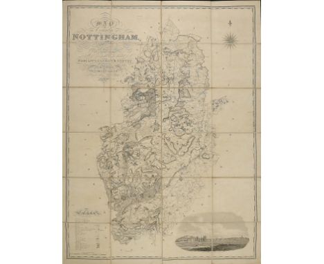
Lot 804
SANDERSON (GEORGE) MAP OF THE COUNTY OF NOTTINGHAM FROM A CAREFUL SURVEY MADE IN THE YEARS 1834 & 1835....BY THE PROPRIETOR GEO SANDERSON, SURVEYOR scale 0.5inch:1 mile, hand coloured engraving by J & C Walker, with vignette of Welbeck Abbey, backed on linen on two sheets with maroon cloth boards and NORTH and SOUTH labels, 141 x 216cm in gilt and blind tooled maroon morocco slip case, spine gilt, 1836
Lot 807
GREENWOOD (C & J) MAP OF THE COUNTY OF NOTTINGHAM FROM AN ACTUAL SURVEY MADE IN THE YEARS 1824 & 1825 scale 1inch: 1mile, engraving with vignette of the South Prospect of Nottingham backed on linen, 140 x 104cm, dark green cloth gilt, Greenwood, Pringle & Co, 1826 § Frederick Jackson - Plan of the Town and County of the Town of Nottingham, scale approx 6.75inch:1mile, lithograph backed on linen, maroon cloth, Nottingham 1866 § John Tuke A Map of Ninety Miles by Seventy Five in which Chesterfield is the Centre..., hand coloured engraving backed on linen, slip case, 1798 (3)
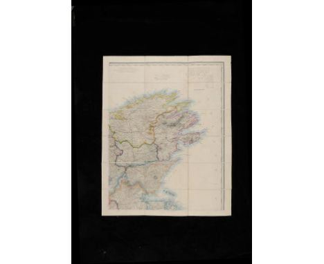
Lot 808
WYLD (JAMES) MAP OF IRELAND COMPILED FROM THE SURVEYS OF THE BOARD OF ORDNANCE AND OTHER APPROVED DOCUMENTS OF THE RAILWAY COMMISSIONERS....BY... JAMES WYLD scale 1.25inch:5 Irish miles, engraving in vivid contemporary colour on four sheets backed on linen, 156 x 122cm, slip case with printed label, worn and torn, c1840

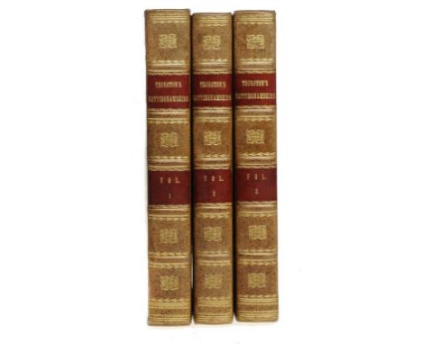
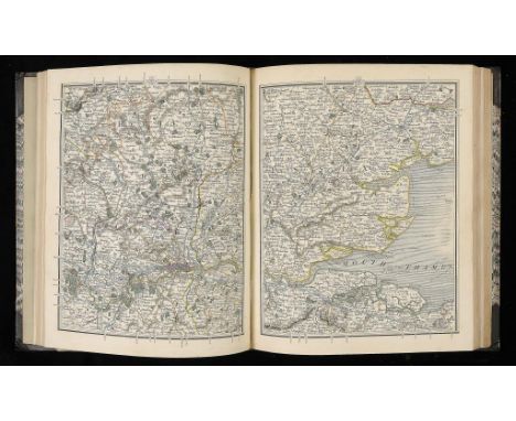
Lot 813
THROSBY (JOHN) THOROTON'S HISTORY OF NOTTINGHAMSHIRE REPUBLISHED WITH LARGE ADDITIONS three vols, plates, several folding and map, portrait, vignette titles and illustrations in the text, later handsome panelled, sprinkled calf, spine gilt, Brough Maltby's copy with his engraved bookplate, 1797 (3) Provenance: The Venerable Canon Brough Maltby, MA (1826-1894) ++++


-
109198 item(s)/page