We found 109198 price guide item(s) matching your search

Refine your search

Year

Filter by Price Range
  • List
  • Grid
  • 109198 item(s)
    /page

Lot 288

Glasgow. Richmond (George, publisher), New Map round Glasgow from the Ordnance Survey, with Two Miles Radiating Circles, Scale 2 Miles to an Inch, Birmingham, 1884, large scale lithographic map with bright contemporary outline colouring, sectionalised and laid on linen, 1020 x 1340 mm, marbled endpapers, contemporary cloth boards with red morocco gilt title label to upper coverQty: (1)

Lot 289

Gloucestershire. Blaeu (Johannes), Glocestria Ducatus vulgo Glocestershire, Amsterdam circa 1646, engraved map with contemporary hand-colouring, large decorative cartouche and mileage scale, 410 x 495 mm, Latin text on verso, together with Herefordia Comitatus Hereford-Shire, Amsterdam, circa 1648, engraved map with contemporary hand-colouring, 410 x 495 mm, French text on versoQty: (2)

Lot 29

Raffles (Lady Sophia). Memoir of the Life and Public Services of Sir Thomas Stamford Raffles, particularly in the government of Java, 1811-1816, Bencoolen and its dependencies, 1817-1824; with details of the commerce and resources of the Eastern Archipelago, and selections from his correspondence, 2 volumes, new edition, London: James Duncan, 1835, portrait frontispiece to first volume, one folding uncoloured aquatint plate of the Rafflesia Arnoldi (the stinking corps lily native to the rainforests of Sumatra and Borneo), the second volume with folding facsimile letter at front, and 2 folding engraved maps (Sketch of the Island of Singapore, & Map of the Indian Archipelago), mottled edges, contemporary uniform brown half calf, spines gilt with maroon morocco labels, a few minor marks (otherwise a very good copy), 8voQty: (2)

Lot 290

Gloucestershire. Speed (John), Glocestershire contrived into thirty thre several hundreds and those againe in to four principall devisions. The Citie of Glocester & Bristow discribed with the armes of such noble men as have bene dignified with ye titles of earles & Dukes thereof, Thomas Bassett & Richard Chiswell [1676], hand-coloured engraved map, inset town plans of Gloucester and Bristol, several repaired closed tears affecting the printed image, some marginal fraying and repaired closed tear, the whole backed with Japanese paper, 385 x 515 mm, English text on verso, together with another copy from circa 1611, several repaired closed tears, trimmed to neatline, laid on Japanese paper, 380 x 510 mm, with Hantshire described and divided, Thomas Bassett & Richard Chiswell [1676], hand-coloured engraved map, an inset town plan of Winchester, toned overall, central fold strengthened on verso, several small repaired closed tears along the central fold, 380 x 505 mm, English text on versoQty: (3)

Lot 291

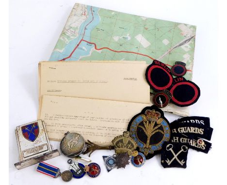
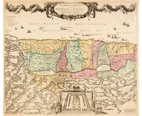
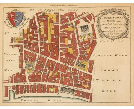
Holy Land. Ottens (Reiner & Joshua), Het Beloofde Landt Israels. Terra Sancta sive Promissionis, olim Palestina..., Amsterdam, circa 1765, engraved map with contemporary outline colouring, orientated to the west, large uncoloured cartouche decorated with a long floral garland supported by cherubim, inset plan of the tribes camped around the Tabernacle, flanked by Moses and Aaron, 505 x 595 mm, together with Delamarche (Charles Francois). Carte de la Terre des Hebreux ou Israelites Partagee selon l'Ordre de Dieu aux Douze Descendantes des Douze Fils de Jacob..., Paris, circa 1790, hand-coloured engraved map after Sanson, large decorative cartouche, inset map of the Monarchy of the Hebrews, slight creasing, two wormholes affecting image, 490 x 685 mm, with Sanson (Nicolas). Geographiae Sacrae ex Veteri et Novo Testamento desumpta Tabula Seconda in qua Terra Promissa sive Judaea..., 1662, hand-coloured engraved map, decorative floral cartouche, slight creasing, 395 x 505 mm, plus Covens (Jean & Mortier Cornelius). Carte de la Turquie De L'Arabie et de la Perse..., circa 1730, engraved map with contemporary outline colouring, large uncoloured cartouche, title repeated above map in Latin, 485 x 580 mm and Munster (Sebastian). Syria / Cypern / Palestina / Mesopotamia / Babylonia / Chaldea und Zwei Arabia mit Bergen Wassern und Stetten, circa 1578, hand-coloured woodblock map, small holes affecting image repaired on verso, some creasing, margins strengthened on verso, 320 x 360 mm, German text on verso, together with Zatta (Antonio). Terra di Canaan ov. Terra Promessa..., Venice, 1785, engraved map with contemporary outline colouring, inset map of the tribes of Israel, 325 x 420 mm, with Conder (Lieuts C. R. & Kitchiner H. H. surveyors). Map of Western Palestine..., Special edition Illustrating the New Testament and the Talmud and Josephus..., published for the Committee of the Palestine Exploration Fund by Edward Stanford, 1882, colour lithographic map, sectionalised and laid on linen, marbled endpapers, 1520 x 890 mm, contained in a contemporary cloth slipcase with printed label to upper cover, slipcase faded and worn at extremities, plus another four maps of the Holy Land and the Middle East, including examples by Cruchley, Zatta, Wyld and Stanford, various sizes, all in good conditionQty: (11)

Lot 294

Kent & Sussex. Muggeridge (Charles J.), Map of the Hop District of Kent and Sussex, shewing the Canterbury, Rochester and Sussex Collections of the Duty, number of acres in cultivation in each Parish and the Divisions of the Several Growths in the County of Kent. Dedicated by Permission to the Chairman & Directors of the London & Dover (South Eastern) Railway Company..., 1844, lithographic map with contemporary outline colouring, sectionalised and laid on linen, compass rose, triangular distance tables, table of explanation and a list of the number of acres in cultivation in each county, some staining, 630 x 990 mm, card endpapers (one lacking)Qty: (1)NOTESA scarce and unusual 'agricultural' map of Kent. Not recorded on Copac.

Lot 295

Lancashire. Speed (John), The Countie Pallatine of Lancaster Described and Devided into Hundreds, Thomas Bassett & Richard Chiswell [1676], hand-coloured engraved map, inset town plan of Lancaster and decorated with eight portraits of Plantagenet monarchs, small repair at base of central fold, some marginal fraying and staining, 385 x 515 mm, English text on versoQty: (1)

Lot 297

Lincolnshire. Blaeu (Johannes), Lincolnia Comitatus Anglis Lincoln-shire, Amsterdam, circa 1646, engraved map with contemporary hand-colouring, 420 x 500 mm, Latin text on versoQty: (1)

Lot 298

Lincolnshire. Speed (John), The Countie and Citie of Lincolne Described with the armes of them that have bene Earles thereof since the Conquest, circa 1627, hand-coloured engraved map, inset town plan of Lincoln, one small repaired hole affecting image, some marginal fraying and closed tears, vertical borders trimmed with the loss of the printed strapwork margins and replaced in facsimile, 385 x 515 mm, English text on verso, together with Norfolk a Counties Florishing & Populous described and divided with the armes of such Noble Familes as have borne the titles thereof, John Sudbury & George Humble, circa 1627, hand-coloured engraved map, inset town plan of Norwich, some marginal repaired closed tears to lower margin, 380 x 510 mm, English text on versoQty: (2)

Lot 299

Lincolnshire. Speed (John), The Countie and Citie of Lyncolne Described with the Armes of them that have bene Earles thereof since the conquest, 1st edition [1611], hand-coloured engraved map, inset town plan of Lincoln, large strapwork cartouche and compass rose, some repaired marginal closed tears, central fold partially stained and crudely strengthened and repaired on verso390 x 515 mm, English text on verso, mountedQty: (1)

Lot 300

* London. Noorthouck (John), A collection of 16 ward plans, 1772, hand-coloured engraved ward plans, originally published in Noorthouck's 'A New History of London, Including Westminster and Southwark', slight staining and offsetting, each approximately 175 x 230 mm, uniformly mounted, framed and glazed, together with Moule (Thomas). Essex, circa 1845, hand-coloured engraved decorative map, 205 x 260 mm, mounted, framed and glazed, with another copy similarQty: (18)NOTESThe plans are reduced versions of Benjamin Cole's maps of 1756. The ward plans consist of:- Tower Street Ward, Broad Steet Cornhill Wards, Cripplegate Ward, A New and Accurate Plan of Walbrook and Dowgate Wards, Queen Hith and Vintry Wards, Aldersgate Ward, A New and Accurate Plan of Billingsgate Ward and Bridge Ward within, Portsoken Ward, Cheap Ward, Breadstreet and Cordwainers Ward, Baynards Castle Ward and Faringdon Ward within, Lime street Ward, Bishops Gate Ward, Farringdon Ward without, Aldgate Ward [and] Candlewick and Langborn Wards.

Lot 301

London. Rocque (John), A New and Accurate Survey of the Cities of London and Westminster, The Borough of Southwark with the Country about it for nineteen Miles in Length and thirteen in Depth..., Begun in 1741, finish'd in 1745 and published in 1746 and 1748..., Sold by the Proprietor John Roque and printed by W. Edwards at the Globe without Newgate, 1748, title page printed in red & black with the title repeated in Latin and French, inset allegorical vignette, list of subscribers with an index of the Towns and villages in the survey and a list of the Noblemen's Seats, Colleges and Hospitals printed on the verso, double-page general keymap and 16 (complete) uncoloured double-page maps engraved by R. Parr, one map with a small printer's fold, very slight marginal spotting, later endpapers, bookplate of Harry Lawrence Bradfer-Lawrence, modern red half morocco over marbled boards, gilt decorated spine with contrasting green morocco label, slim upright folioQty: (1)NOTESJ. Howgego. Printed Maps of London, 94.4. This is the second of Rocque's large scale plans of London and if assembled would measure approximately 1980 x 3960 mm. The map sheets are clean and bright.

Lot 304

Middlesex. Blaeu (Johannes), Middle-Sexia, Amsterdam circa 1648, engraved map with contemporary hand colouring, decorative allegorical cartouche, 390 x 405 mm, French text on verso, together with Cantium vernacule Kent, Amsterdam, circa 1648, engraved map with contemporary hand-colouring, 390 x 530 mm, French text on versoQty: (2)

Lot 305

Middlesex. Rocque (John), A Map of the County of Middlesex from an Actual Survey in four Sheets, 1757, engraved map with contemporary outline colouring, sectionalised and laid on linen, title repeated in French, mileage scale, compass rose and a decorative cartouche showing a surveyor using a waywiser, some wear and splits to the linen along old folds, edged in green silk (frayed), 520 x 685 mm, retaining the boards of a contemporary marbled card slipcase with near-contemporary ink manuscript title to the upper coverQty: (1)

Lot 308

Northamptonshire. Speed (John), Northamptonshire, Henry Overton, [1713 - 43], hand-coloured engraved map, inset town plans of Northampton and Peterborough, some creasing, slight marginal fraying, 385 x 500 mm, no text on verso, together with Glocestershire contrived into thirty thre several hundreds and those againe in to four principall devisions. The Citie of Glocester & Bristow discribed with the armes of such noble men as have bene dignified with ye titles of earles & Dukes thereof, John Sudbury & George Humble, circa 1627, hand-coloured engraved map, inset town plans of Gloucester and Bristol, trimmed to neatline, central fold strengthened on verso, dust-soiled and toned, 380 x 510 mm, English text on versoQty: (2)

Lot 310

* Ogilby (John). The Road from the City of Salisbury com Wilts to Camden com Gloc. [and] The Road from Oxford to Bristol, circa 1676, together 2 hand-coloured engraved strip road maps, the road from Salisbury to Camden is toned overall, the road from Oxford to Bristol is dust-soiled and creased, each approximately 335 x 440 mm, uniformly mounted, framed and glazed, together with Gardner (Thomas). The Road from the City of Salisbury com Wilts. to Camden com Glocestr. [and] The Road from Oxford to Bristol, [1719], together 2 hand-coloured engraved strip road maps, each approximately 170 x 270 mm, mounted, framed and glazed, with Bowen (Emanuel & Owen John). Road map from Abingdon to Monmouth & The Road from Monmouth to Cardiff [1720 or later], two hand-coloured engraved strip road maps, printed on both sides, 180 x 115 mm, mounted, framed and glazedQty: (6)

Lot 311

* Ogilby (John). The Road from Tinmouth in Northumberld. to the City of Carlise in Cumberld. circa 1676, hand-coloured engraved strip road map, slight toning, marginal repaired tears, slight creasing, 330 x 445 mm, framed and glazed, together with Collins (Captain Greenville). The River Humber..., [1693 - 1779], uncoloured engraved sea chart, 450 x 565 mm, framed and glazed, with Gardner (Thomas). The Continuation of the Road from York to West Chester [and] The Continuation of the Road from London to Barwick..., [1719], together 2 hand-coloured engraved strip road maps, slight toning, each approximately 175 x 275 mm, mounted, framed and glazed, plus two hand-coloured engraved road maps in Yorkshire from Owen & Bowen's 'Britannia Depicta', each approximately 185 x 125 mm, framed and glazed, and Rocque (John). Surrey, circa 1753, hand-coloured engraved map, 165 x 205 mm, framed and glazed, with two maps (of England & Wales and Leicestershire) by George Cooke in one frame and two small framed engravings of Beverley and Hull, various conditionQty: (10)

Lot 312

* Oxfordshire. Speed (John), Oxfordshire described with ye Citie and the Armes of the Colledges of ye famous University Ao 1605, John Sudbury and George Humble, circa 1627, hand-coloured engraved map, inset town plan of Oxford, the vertical margins decorated with 18 shields of university colleges, some creasing, central fold strengthened and repaired on verso, 380 x 510 mm, English text on verso, mounted, framed and double glazedQty: (1)

Lot 319

Pomerania. De Jode (Cornelius), Pomerania utriusq Contientis..., [on sheet with] Thietmarsorum Simbricae Chersonesi Populorum..., Antwerp [1593], two uncoloured maps on one sheet (as published), 165 x 460 mm and 150 x 230 respectively, Latin text on the versoQty: (1)NOTESThe second edition of De Jode's map of Pomerania with the map of Prussiae now removed.

Lot 320

Prussia. Homann (Johann Baptist), Regnum Borussiae..., Nuremberg, 1701, engraved map with contemporary hand colouring and some later enhancement to the large allegorical cartouche, trimmed to neatline with three margins extended, slight spotting, some areas of the margins restored and replaced in facsimile, 480 x 570 mm, together with another slightly later example with the portrait of Frederick III replaced by a Prussian eagle, some fraying and staining to the margins, with Homann (Johann Baptist, heirs of). Tabula Geographica Totam Borussiam ut et Districtum Notecensem..., Nuremberg, circa 1772, engraved map with contemporary outline colouring, inset map of the 'Netz District', 485 x 565 mmQty: (3)

Lot 321

Prussia. Zatta (Antonio), Il Regno de Prussia con la Prussia Polacca..., Venice, 1781, engraved map with contemporary outline colouring and some later enhancement to the cartouche, slight marginal staining, 320 x 415 mm, together with Schedel (Hartmann). Prussia nunc germanie provincia, Nuremberg, circa 1495, uncoloured woodblock, Latin text above and on the verso of the image, overall size 390 x 250 mm, image size 235 x 230 mm, with Probst (Johann Michael). Das Königreich Preussen nebst dem Polnischen Antheil..., Augsburg, 1787, engraved map with contemporary outline colouring, slight overall toning, 170 x 255 mm, with another copy similar, plus Chamouin (Jean Baptiste Marie). Prusse. Gd. Duché de Varsovie, Paris, circa 1800, engraved map with contemporary outline colouring, 220 x 300 mm, with another copy similar, and Rizzi Zanoni (Giovanni Antonio). untitled engraved map of Prussia and Poland with contemporary hand-colouring, 315 x 460 mm, with another uncoloured copy with Russian text, together with another three maps similar, including examples by Cary, Remondini (publisher) and Walch, various sizes and conditionQty: (11)

Lot 323

Russia. Jansson (Jan), Russiae, vulgo Moscovia Dictae, Partes Septentrionalis et Orientalis. Auctore Isacco Massa, Amsterdam, circa 1650, engraved map with contemporary outline colouring, slight overall toning, slight spotting, some text show through, slight fraying to lower corners,420 x 540 mm, Dutch text on versoQty: (1)

Lot 325

Scandinavia. Rossi (Giacomo Giovani), La Scandinavia Divisa nelli suoi Regni di Svezia, Danemarca, Norvegia, e Paese de Lapponi..., Rome, circa 1678, decorative map engraved by Giorgi Widman with contemporary outline colouring, large martial cartouche and mileage scale, slight spotting, 420 x 555 mmQty: (1)

Lot 326

* Scotland. Senex (John), A New Map of Scotland according to Gordon of Straloch, 1721, engraved map with contemporary outline colouring, additional title "A New Mapp of Scotland, the Western, Orkney and Shetland Islands, Most Humbly Inscrib'd to His Grace the Duke of Hamilton & Brandon &c.", inset map of The Shetland Islands, one closed tear affecting the image, slight staining, 565 x 470 mm, framed and glazedQty: (1)

Lot 329

Surrey. (Bowen (Emanuel), An Accurate Map of the County of Surrey Divided into its Hundreds..., Carington Bowles & Robert Sayer, circa 1765, engraved map with contemporary outline colouring, originally published in 'The Large English Atlas', several marginal closed tears, slight creasing and dust soiling, torn with loss to the plate mark but not affecting the printed image, toned overall, laid on later card, 540 x 720 mm, together with Blaeu (Johannes). Comitatus Salopiensis Anglice Shrop Shire, Amsterdam, circa 1648, engraved map with contemporary hand colouring, some spotting and staining, laid on later card, 390 x 500 mm, mountedQty: (2)

Lot 330

The Americas. Homann (Johann Baptist, heirs of), Americae Mappa Generalis Secundum Legitimas Projectionis Stereographicae Regulas ... Concinnata et Delineata ab Aug. Gott Boehmio Phil. Magistro...., Nuremberg, 1746, engraved map with contemporary outline colouring, large uncoloured allegorical cartouche, 470 x 540 mmQty: (1)

Lot 332

Tokyo. Takehara Yoshibei (publisher), [Edo], circa 1860, engraved map with contemporary outline colouring, large table of explanation and four compass rose, slight abrasion to the printed surface, old folds with wear causing slight loss, slight dust soiling, 410 x 330 mm, retaining one cloth boardQty: (1)

Lot 333

Wales. A collection of 43 maps and plans, 18th & 19th century, including Langley & Belch (publishers). Langley's new Map of Montgomeryshire, Langley's New Map of Brecknockshire [and] Langley's New Map of Flintshire, 1818, together 3 engraved maps with contemporary outline colouring, sectionalised and laid on linen, each approximately 200 x 270 mm, each contained in a contemporary marbled card slipcase with a black on orange printed label to the upper cover, with another 28 engraved Welsh county maps, including examples by Owen & Bowen, Morden (small & large format), Saxton/Kip, Kitchin, Cary, Pigot, Seller/Grose and Langley, plus 11 Welsh boundary commission maps by Robert Dawson and Henry James, each approximately 240 x 200, mounted, and Cary (John). England and Wales, 1806, engraved map with contemporary outline colouring, 150 x 100 mm, mountedQty: (43)

Lot 337

Wales. Blaeu (Johannes), Wallia Principatus vulgo Wales, Amsterdam, circa 1646, engraved map with contemporary outline colouring, slight spotting, slight text show through, 385 x 500 mm, Dutch text on versoQty: (1)

Lot 338

Wales. Speed (John), Cardigan Shire Described with the due forme of the Shire Town as it was Surveyed by J. S. J. Sudbury & G. Humble, [1611 or later], hand-coloured engraved map, inset town plan of Cardigan, some repaired marginal closed tears to lower margin, laid on later card, 385 x 515 mm, together with The County of Monmouth with the situation of the Shire-towne described, Thomas Bassett & Richard Chiswell [1676], uncoloured engraved map, inset town plan of Monmouth, laid on later card, 390 x 515 mmQty: (2)

Lot 340

* Warwickshire. Speed (John), The Counti of Warwick, The Shire Towne and Citie of Coventre described, John Sudbury & George Humble, circa 1627, hand-coloured engraved map, inset town plans of Warwick and Coventry, large strapwork cartouche and mileage scale, 385 x 510 mm, English text on verso, framed and double-glazedQty: (1)

Lot 341

* Wiltshire. Saxton (Christopher), Wiltoniae comitatus (Harbida planicie nobilis) hic ob oculos proponitur..., [1579], uncoloured map engraved by Remigius Hogenbergus, large ornate strapwork cartouche surmounted by the royal coat of arms of Elizabeth I, with the coat of arms of Thomas Seckford, very slight browning to central fold, trimmed with the loss of the strapwork margin along the lower margin and replaced in facsimile, 425 x 480 mm, mounted, framed and glazedQty: (1)

Lot 342

World. Bowles & Carver, Bowles's New Four-Sheet Map of the World, on Mercator's Projection, exhibiting the Several Quarters of the Globe, divided into their respective Empires, Kingdoms, States, &c., agreeable to the latest treaties and political regulations now existing; together with all the new discoveries and most interesting tracks of those eminent circumnavigators, Cook, Byron, Bougainville, Perouse, Vancouver &c. circa 1800, engraved map with contemporary hand colouring, sectionalised and laid on linen, large uncoloured decorative cartouche and compass rose, some overall toning, 1050 x 1210 mm, contained in a contemporary marbled slipcase with publisher's printed label to the upper cover, slipcase worn and frayedQty: (1)

Lot 343

Yorkshire. Blaeu (Johannes), Ducatus Eboracensis pars Occidentalis; The West Riding of Yorke Shire, Amsterdam, circa 1648, engraved map with contemporary hand-colouring, slight adhesion scaring, 385 x 500 mm, French text on verso, with another copy similar, but with some mount staining, slight oxidization to the old watercolour and with the left-hand vertical margin trimmed and extendedQty: (2)

Lot 4

Douglas Cockerell binding. General Sir Richard Meade and the Feudatory States of Central and Southern India. A Record of Forty-Three Years' Service as Soldier, Political Officer and Administrator, by Thomas Henry Thornton, 1st edition, London: Longmans, Green, 1898, portrait frontispiece, folding map (small reinforcement to verso), half-tone illustrations, marginal offsetting to endpapers, all edges gilt, contemporary green morocco by Douglas Cockerell, upper cover with foliate design in gilt with initials 'M W D H E', spine a little rubbed, spine and extremities faded to brown, 8voQty: (1)NOTESThe binding was commissioned by Sir Willoughby Dickinson (1859-1943) for his wife, whose father was General Sir Richard Meade. Douglas Cockerell (1870-1945) was a bookbinder, his elder brother Sydney Cockerell was William Morris's secretary. He learned his craft under T.J. Cobden-Sanderson at the Doves Bindery in Hammersmith before opening his own bindery in 1897, and later taught at the London County Council Central School of Arts and Crafts and at the Royal College of Art.

Lot 41

Cary (John). Cary's New and Correct English Atlas: Being a New Set of County Maps from Actual Surveys..., 1st edition, Sept 1st. 1787, calligraphic title with two later manuscript ownership signatures, advertisement and dedication, 47 (complete) engraved maps with contemporary outline colouring, each with a page of descriptive text and tissue guard, near-contemporary manuscript number to verso and recto of each map, slight spotting to tissue guards, index and list of subscribers bound at rear, near-contemporary manuscript contents list on the verso of the front blank and the first free endpaper, joints and hinges weak, contemporary calf gilt with a contrasting red morocco label to spine, slight wear, 4toQty: (1)NOTESChubb CCLX. This copy with a slightly odd pagination, with the maps of the northern counties first and the southwestern counties last.

Lot 42

Chamberlain (Henry). A New and Compleat History of the Cities of London and Westminster, the Borough of Southwark, and parts adjacent; from the earliest accounts, to the year 1770, London: J. Cooke, [1770], engraved frontispiece and 64 plates, folding plan of London, folding engraved map of twenty miles around London (torn with loss), repaired closed tears to frontispiece, title and few other plates etc., some other short closed tears mostly to plate margins, occasional light dust-soiling and spotting, contemporary reversed calf, red morocco title label to spine, joints split at head & foot, some wear to extremities, folio, together with: Bentham (James), The History and Antiquities of the Conventual and Cathedral Church of Ely, from the Foundation of the Monastery, A.D. 673, to the Year 1771, 2 volumes in one, 1st edition, Cambridge: Printed at the University Press by J. Bentham, 1771, engraved folding frontispiece, 47 engraved views & plans on 45 plates (7 folding; plates 48-50 engraved on a single folding sheet), front blank with early 19th century manuscript note, later pencil note 'Heber - Phillipps copy', 20th century bookplate of Katharine Hely-Hutchinson of Chippenham Lodge, Ely, contemporary calf, gilt decorated spine and morocco title label (worn with loss), joints split, rubbed and worn, 4to, and other miscellaneous books including Cary's New Itinerary, 11th edition, 1828 and A Dictionary of Greek and Roman Antiquities, edited by William Smith, 1842Qty: (8)

Lot 43

Dearn (Thomas Downes Wilmot). Historical, Topographical and Descriptive Account of the Weald of Kent, Cranbrook: S. Reader, 1814, eight uncoloured aquatint plates (including frontispiece), etched map, occasional marks, spotting and light offsetting, edges untrimmed, modern gilt decorated calf, contrasting morocco & calf labels to spine, 8vo, together with: Blomefield (Francis), The History of the City and County of Norwich, Containing it's Original Rise, and Increase..., a Description of the Streets, Walls, River, remarkable Houses, and other things..., Fersfield: Printed at Fersfield, 1741, title in red & black, 5 engraved plates only (of 8, one with repaired closed tear), engraved illustration to text, list of subscribers, short worm trails to few leaves at rear of volume, rear free endpaper detached, contemporary blind panelled calf gilt, joints cracked and some wear to extremities, folio (Upcott p.945-47), Bibliotheca Topographica Britannica, Nos. 27-41, in one volume, London: J. Nichols, 1783-87, numerous etched & engraved plates (some folding), bound with Pegge (Samuel), Annales Eliae de Trickingham..., London: Ex Officina Nicholsiana, 1789, edges untrimmed, contemporary half calf gilt, 4to, and one other defective volumeQty: (4)NOTESESTC T226404 and Upcott, p. 945-7. Three UK institutional locations found (Birmingham University Library, Cambridge University Special collections & Norwich Cathedral). This is a self-contained volume on Norwich, being Volume 2 of the first edition of Blomefield's work on Norfolk 'A Essay towards a Topographical History of the County of Norfolk, 1739'. The number of plates within this work appears to vary from 5, 6 or 8. Upcott calls for eight plates, with this copy lacking the city plan and also the monument of Bishop Hall in Heigham Church.

Lot 45

Finden (E. & W.). The Ports, Harbours, Watering-Places, and Picturesque Scenery of Great Britain, illustrated by views taken on the spot, 2 volumes, London: George Virtue, c.1841, 144 engraved plates, after Bartlett, Harding and Creswick, including frontispiece and additional titles (complete as list), 4pp. publisher's advertisements at rear of 1st volume, some spotting, volume I with intermittent dampstain to upper blank margins (affecting head of additional title), all edges gilt, original blind-stamped cloth, rubbed and lightly marked, some wear to extremities, spines a little cocked, 1st volume front cover stained at head, gilt-decorations to spines and front covers, 4to, together with: Virtue (George, publisher), The Picturesque Beauties of Great Britain - Kent, London, c.1831, engraved frontispiece, additional title, and 128 engraved plates on 64 leaves, folding engraved map (lightly offset), generally spotted and lightly toned, minor dampstaining to gutters of first few leaves, frontspiece and additional title a trifle edge-frayed, frontispiece edge-chipped with closed edge tears, one plate leaf edge-frayed and with long closed tear (repaired on verso), endpapers renewed, original maroon half morocco, with printed title and vignette to front board, rebacked, worn, 4to, plus: Morris (F. O.), A Series of Picturesque Views of Seats of the Noblemen and Gentlemen of Great Britain and Ireland, 4 volumes, c.1880, additional decorative titles, numerous chromolithographed plates, letterpress toned with light spotting (lightly affecting some plate margins), three plates (with accompanying text leaf) detached, all edges gilt, publisher's decorative cloth gilt, rubbed with some wear to extremities, a few minor marks, 4to, and three others similarQty: (10)

Lot 49

Ingram (James). Memorials of Oxford, 3 volumes, Oxford: John Henry Parker & London: Charles Tilt, 1837, large paper copy, vignette titles, 100 engraved plates (spotted), one uncoloured engraved map, numerous wood-engravings to text, plates in volume I with minor dampstain at head of gutters, each front pastedown with bookplate removed, all edges gilt, contemporary half maroon marocco gilt, rubbed with a little wear to extremities, spines with small circular label removed, volume I front cover nearly detached and light dampstain to rear joint, 4to, together with: [Skelton, J., publisher], [Skelton's Engraved Illustrations of the Antiquities of Oxfordshire, Oxford: for J. Skelton, 1823], large paper copy, bound from the parts, printed front wrapper from part XII bound in at front, lacking title and frontispiece, 47 (of 49) engraved plates, one uncoloured engraved map, numerous engraved vignettes in letterpress, subscriber's list, plates spotted (mainly affecting blank margins), contemporary half black morocco gilt, rubbed with some wear to extremities, front cover stained, folioQty: (4)

Lot 51

Mudie (Robert). Hampshire: Its Past and Present Condition and Future prospects, 3 volumes, James Robbins. Winchester, [1838 - 39], additional pictorial half-title and dedication to each volume, 131 uncoloured engraved plates, 3 folding maps (Hampshire, The Isle of Wight and The Channel Islands), the map of Hampshire with a closed handling tear and six single-page engraved maps, very slight spotting throughout, contemporary gilt calf with contrasting morocco labels to the gilt-decorated spines, joints partially split, bumped with slight staining to boards, 8voQty: (3)NOTESThe third volume comprises of the Isle of Wight and the Channel Islands.

Lot 54

Pountney (W. J.). Old Bristol Potteries..., 1st edition, Bristol: J. W. Arrowsmith Ltd., 1920, signed & inscribed by the author to the half-title, colour frontispiece, 55 black & white plates plus folding map to the rear, some light spotting to the endpapers & text block, publishers original red cloth, spine slightly faded with minor rubbing, 8vo, together with; Bristol Records Society, a broken run of 31 volumes, volume 15 - 50 (1949-99), some minor toning, all in the publishers original boards with cloth spines, 8vo, and The Bristol and Gloucestershire Archaeological Society, a broken run of 19 volumes, volume 10 - 137 (1998- 2019), all in the publishers original cloth in dust jackets/wrappers, 8vo, plus other Bristol reference, including 5 volumes by John Latimer, 8voQty: (58)

Lot 55

Shaw (Stebbing). The History and Antiquities of Staffordshire, compiled from the manuscripts of Huntbach, Loxdale, Bishop Lyttelton, and other collections of Dr. Wilkes. The Rev. T. Feilde, &c. &c. including Erdeswick's survey of the county; and the approved parts of Dr. Plot's Natural History. The whole brought down to the present time..., 2 volumes [volume 1 and volume 2 part 1 (all published)], London: printed by and for J. Nichols, 1798-1801, half-titles discarded, early signature at head of title pages (vol. 1 title creased), two folding engraved maps (county map linen-backed), 82 engraved and aquatint plates (few folding), four folding genealogical tables, engraved illustrations, few neatly repaired short marginal closed tears, some offsetting, occasional browning and scattered spotting, all edges gilt, contemporary black morocco, gilt panelled borders to spine compartments and boards, folio (42 x 26 cm)Qty: (2)NOTESUpcott pp. 1176-1185. A handsome set.

Lot 91

Knight (Richard Payne). Nummi Veteres civitatum, regum, Pentium, et provinciarum Londini in muse Tichardi Payne Knight Asservati, London: Gulielmus Nicol, 1830, marginal pencil annotations, front & rear gutters cracked, some light toning & spotting, Latin & Greek language, contemporary half half to marbled boards, boards & spine slightly rubbed with minor loss to head & foot, 4to, together with; Drake (Francis), Eboracum: or, the History and Antiquities of the City of York,...and a description and history of the cathedral church,...2 volumes, York: printed for T. Wilson & R. Spence, 1788, folding map frontispiece to volume 1, black & white engraved plates, bookplates to the front pastedowns, some light spotting & toning, later paper spines to blue boards, boards & spines rubbed & marked, 8vo, and Pinkerton (John), An Essay on Medals: or an introduction to the knowledge of ancient and modern coins and medals;..., 2 volumes, 3rd edition, London: printed for T. Cadell & W. Davies, 1808, book plates to front pastedowns, some light spotting & marginal toning, uniform contemporary gilt decorated plum half calf, boards & spines faded & rubbed, 8vo, plus other 18th & 19th numismatic & miscellaneous reference, some odd volumes, mostly leather bindings, some rubbed with loss, 8vo/4toQty: (31)

Lot 96

Mantell (Gideon). The Geology of the South-East of England, 1st edition, London: Longman, Rees, Orme, Brown, Green & Longman, 1833, half-title discarded, lithograph frontispiece, title with wood engraved vignette (both leaves washed), five lithograph plates (including one folding), folding colour geological map (few tears with slight loss, archival tissue-lined to verso), illustrations to text, chapter 10 with few coloured pencil markings to blank margins, occasional light toning, modern half calf, contrasting morocco labels to spine, 8voQty: (1)NOTESChapter 10 refers to Mantell’s discovery of a fossilised dinosaur in the Weald in 1832. It was the first armoured dinosaur discovered and he named it Hylaeosaurus or ''fossil lizard of the Weald'', proving that some dinosaurs at least had dwelt on land.

Lot 494

A collection of Welsh Guards military and sporting items, for the British Army, inter Rugby Championships 1952, winners medal awarded to the Second Lieutenant David Howard Davis of the First Battalion the Welsh Guards and an Army Rugby Union medal awarded to the same 1951 to 1952, an enamel fob for the North Wales Centre ACU, a miniature National Service medal from 1939 to 1960, military cloth and other badges, to include Welsh Guards, a map of Berlin, Berlin metal and cloth badges, etc.

Lot 495

A collection of items, to include a Tank Corp military badge, various crustacean picks, a silver plated corkscrew-bottle opener, a map measurer, and a pewter tankard, titled Kings tankard, engraved with the Monarchs of England.

Lot 535

After John Ogleby. The Road from Nottingham to Grimsby, later coloured road map, 34cm x 36cm, and a print of the North West prospect of Barling's Abbey near Lincoln, After Samuel Buck. (2)

Lot 579

Railway Clearing House Official Railway Map of England and Wales, 1913. Large fold out linen-backed map in very good condition. Road Atlas of Great Britain, John Bartholomew & Son, 1966, Hardback, good condition. (2)

Lot 620

The Emerald Isle Album City and County of Dublin, Sixty-Four Platinatone Views with Descriptive Guide and Map of the District from photographs by William Lawrence. No date early 1900’s. Interesting content. Northern Ireland – The Land of Delightful Scenery- Camera Studies, Belfast Telegraph, 1947. Contains 40 full page colour photographs from across the province with descriptive text. Dublin Tenement Life – An Oral History, Kevin C Kearns, Gill & Macmillan, 1994, 2nd Impression, S/C, good condition. Gur Cake and Coal Blocks, Eamonn Mac Thomais, 1978, S/C. An account of Dublin life during the war years.

Lot 626

GENEALOGICAL MAP. Genealogical and History Map of Ireland showing the Five Kingdoms Meath, Ulster, Connaught and Leinster. By J. G. Lee. Showing Irish family names and localities from which they originally came. Coloured. Published in US circa 1890. Size 64 x 89cms.

Lot 725

An Ernest Clegg 1940's map of the Battle of Britain, Kent. 44 cm x 57 cm, framed.

Lot 751

Christopher Saxton (1540-1610), coloured engraving, "Dunelmensis" - Durham and surrounding areas. 27 x 34 cm in oak frame and glazed. A reproduction Saxton map of Northumbria and a Robert Morden coloured engraving, map of Northumberland.

Lot 998

A Christopher Saxton antiquarian map of Cumbria, 32 cm x 39.5 cm.

Lot 149

Two Russell Flint prints, a map and a pencil sketch

Lot 147

The Angler’s Guide to the Irish Free State. Compiled by the Department of Lands and Fisheries. Illustrated with four folding maps and a large linen-backed map of Ireland. Dublin: Stationery Office, 1937. Small 8vo. 1st edition. Original green cloth, title in black on upper cover and along spine. V.g. Rare first ed. The large folding Ordnance Survey map depicts rivers, lakes, and fishery districts. Railways shown in black. Irish-speaking districts are coloured yellow.

Lot 166

Inglis, Henry D. A Journey Throughout Ireland, during the Spring, Summer, and Autumn of 1834. Folding itinerary map and folding chart of the river Shannon. London: Whittaker, 1836. 8vo. 4th edition. Quarter green goatskin on green cloth boards. Signature on title-page. V.g.

Lot 172

Alice Stopford Green. The Makings of Ireland and Its Undoing. 1909. 1st Map;  and   C. Maxwell. County and Town in Ireland under the Georges. 1949. 1st. Illustrated Folding map. (2)

Lot 185

Robert C. Simington. The Civil Survey of the County of Kildare. 1952. 1st. Map of Kildare. Original red cloth.

Lot 325

Antiquarian lot. British Sport Past and Present. Illustrated in colour by Denholm Armour. 1909. Large format; Guide to Peeblesshire and adjacent country with folding map. Circa 1870; Natural History, Sport and Travel by Lockwood. 1878; The Tourist in Italy by Roscoe. 1831; The Meditations of Emperor Aurelius Antoninus by Graves. Bath. 1792; 5 books showing signs of use.

Loading...Loading...
  • 109198 item(s)
    /page

Recently Viewed Lots