We found 109182 price guide item(s) matching your search
There are 109182 lots that match your search criteria. Subscribe now to get instant access to the full price guide service.
Click here to subscribe- List
- Grid
-
109182 item(s)/page


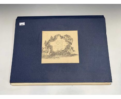
Lot 1248
MAPSFour folding maps, including Road Map of India, col litho, 24 ins by 30 ins, 1942 edn, g; Philips Map of London, col litho, linen-backed, orig covers 24 ins x 30 ins, 1884, vg; Rhodesia, Tanganyika Territory and Kenya Colony, 20 ins by 30 ins, col litho, original covers, Philips Authentic Imperial Maps, c1920, vg; Malta and Gozo, linen-backed col folding map, 24 ins by 30 ins, War Office, 1934, g.


Lot 1407
FACSIMILIE. 'Greenwood Map of County Palatine of Lancaster'. 1992 Facsimilie of Greenwoods 1818 original. Six sheets complete, protective carboard tube. g; Together with 'Hertfordshire Record Society Facsimilie 2004; FACSIMILIE. 'Somerset'. Day & Masters and Greenwood, reprint by Somerset Record Society, 16 maps, cased.


Lot 357
A WWII silk escape map scarf, double sided, Sheet E 'Germany (North), Protectorate (Bohemia & Moravia), Slovakia, Poland, Hungary (North)', Sheet F 'Croatia (W & Central), Montenegro (West), Hungary (West), Slovakia (South), Germany (South), Italy (North & Central), Switzerland (East)' approx. 75x80cm
Lot 358
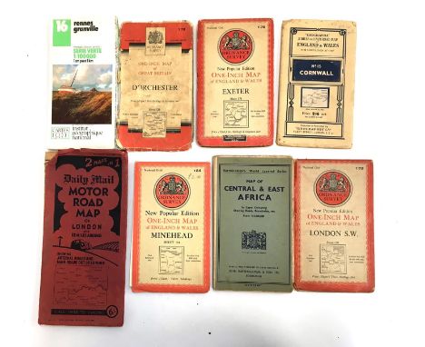
A small collection of maps to include Ordnance Survey maps of Minehead (1946), London S.W (1948), Dorchester (1960), Exeter (1946), a Geographia Ltd. map of Cornwall, Bartholemew's World Layered Series Map of Central & East Africa, and Daily Mail Motor Road Map of London and 10 Miles Around, with one other (8)


![[Maps & Atlases] [Africa] Ortelius, AbrahamGroup of 2 MapsBarbariae et Biledulgerid, nova descriptio(Antwerp, ca. 1570-1612).](https://cdn.globalauctionplatform.com/99ebf729-4b49-425e-ba1f-ac46011af47d/b5dc752a-55ce-4a75-b6e8-ac4601575fb0/468x382.jpg)
Lot 1
[Maps & Atlases] [Africa] Ortelius, AbrahamGroup of 2 MapsBarbariae et Biledulgerid, nova descriptio(Antwerp, ca. 1570-1612). Hand-colored engraving. Coastal map of North Africa and the Mediterranean, from Orteluis' "Theatrum orbis terrarum". French text on verso. Center fold verso reinforced with tape. 17 1/2 x 23 in. (444 x 584 mm). Hinge mounted, in mat.Together with: Presbiteri Iohannis, sive, Abissinorum imperii descriptio(Antwerp, ca. 1608). Hand-colored engraving. Map of the kingdom of mythical African King Prester John, from Ortelius' "Theatrum orbis terrarum". Italian text on verso. Center fold verso reinforced with tape, scattered minor spotting. 18 1/2 x 22 1/8 in. (469 x 561 mm). Hinge mounted, in mat.
![[Travel & Exploration] [Hawaii] Byron, (George Anson)Voyage of H.M.S. Blonde to the Sandwich Islands, in the Years 1824-1825L](https://cdn.globalauctionplatform.com/99ebf729-4b49-425e-ba1f-ac46011af47d/1ce4eb1a-1703-4591-83dc-ac46014e80fb/468x382.jpg)
Lot 10
[Travel & Exploration] [Hawaii] Byron, (George Anson)Voyage of H.M.S. Blonde to the Sandwich Islands, in the Years 1824-1825London: John Murray, 1826. First edition. 4to. x, (ii), 260 pp. Illustrated with folding frontispiece, one folding map, and 13 aquatint and engraved plates. Contemporary three-quarter polished brown calf, stamped in gilt, over marbled paper-covered boards, front board detached but present, extremities and corners lightly worn, red leather spine label; matching marbled edges and endpapers; some paper loss in gutter of front free endpaper, scattered minor spotting to text, creasing to frontispiece. From the library of Henry Casimir de Rham (1785-1873), Swiss-American diplomat and one of the first two Swiss consuls to the United States, and with his book-plate on front paste-down. Hill 231.An account of the H.M.S. Blonde's voyage to Hawaii to return the bodies of King Kamehameha ll and Queen Kamamalu, who passed away from measles while on a state visit to London in 1824. The British government sponsored the voyage, with George Anson Byron, cousin of poet Lord Byron, in command. This volume contains an account of the King's visit, as well as a history of British exploration to the Hawaiian islands.
![[Maps & Atlases] [America] Speed, JohnAmerica, with those known parts in that unknowne worlde both people and manner of build](https://cdn.globalauctionplatform.com/99ebf729-4b49-425e-ba1f-ac46011af47d/59431d94-9bca-490d-a0d6-ac46015ba08d/468x382.jpg)
Lot 2
[Maps & Atlases] [America] Speed, JohnAmerica, with those known parts in that unknowne worlde both people and manner of buildings Discribed and inlarged by I.S. Ano. 1626(London): Thomas Bassett and Richard Chiswell, (1676). Hand-colored engraving. Fourth state. English text on verso. Light spotting in bottom margin; center fold verso reinforced with tape; tape repairs along top and bottom edges. Frame: 19 1/2 x 23 7/8 in. (495 x 606 mm); map: 16 5/8 x 21 in. (422 x 533 mm) (sight). Unexamined out of double-pane glass frame. Burden 217.
![[Maps & Atlases] [Sri Lanka] Fries, LorenzTaprobana(Strasbourg, ca. 1525-35). Uncolored woodblock map. Latin text on verso. C](https://cdn.globalauctionplatform.com/99ebf729-4b49-425e-ba1f-ac46011af47d/260b363f-0875-48b5-bf0b-ac4601621812/468x382.jpg)
![[Maps & Atlases] [Mercator, Gerard] Alexandrini, Cl(audii). PtolemaeiGeographiae libri octo...(Cologne: Godfried von Kempen,](https://cdn.globalauctionplatform.com/99ebf729-4b49-425e-ba1f-ac46011af47d/3095e019-7e52-4ba4-a0aa-ac4601685a1e/468x382.jpg)
Lot 8
[Maps & Atlases] [Mercator, Gerard] Alexandrini, Cl(audii). PtolemaeiGeographiae libri octo...(Cologne: Godfried von Kempen, 1584). Second edition. Edited by Arnold Mylius. Folio (409 x 279 mm). (ii), 106, 89-90, (30), (1) (blank), (142) pp. Illustrated with engraved title-page, numerous in-text woodcut diagrams, and 27 (of 28) maps; lacking map III of Europe ("Continent Galliae, Graecis..."). Full eighteenth century calf, stamped in gilt, boards heavily worn and soiled, spine perished, remnants of later repair along spine and joints; all edges trimmed; engraved title-page worn and soiled, repairs on verso, 3 1/2 in. separation along repair at bottom corner, old ownership signature at foot of same; bottom corner of first 14 leaves tattered with varying loss to text; light to moderate dampstaining in bottom corners of maps VII-XII; fore-edge of final seven leaves worn; scattered minor spotting and worming to text and plates, scattered chipping and short closed tears along edges of same. Sabin 66491. Sold with all faults.Gerard Mercator's (1512-94) second edition of Ptolemy's Geography, and the last edition produced in his lifetime.


Lot 146
LOTTER (TOBIAS CONRAD)Angliae, Scotiae Hiberniae, hand-coloured double-page engraved map, cartouches and coat-of-arms, T585mm x 500mm, [eighteenth century]--COLLINS (CAPT. GREENVILE) Prospect Of Leith From The East, coloured engraving, cartouche, stained, 50mm x 570mm--ORTELIUS (ABRAHAM) Ruinarum arcis Britannicae apud Batavos typus, engraved map, 230mm x 315mm, 1562 [or later]--PONT (TIMOTHY) The Middle Part of Galloway; of Lidisdil, engraved maps, hand-coloured in outline, each approximately 410mm x520mm, [c.1800]--BRYCE (ALEXANDER) The North Coast of Britain, engraved map, cartouche and dedication to the Earl of Morton, torn and stained, 495mm x 695mm, 1744 [or later]--ADAIR (JOHN) The Mapp of Straithern, engraved map, tears repaired, 60mm x 680mm, [1685 or later]--KITCHEN (THOMAS) North Britain Or Scotland, engraved map, 680mm x 545mm, William Faden 1778 (8)For further information on this lot please visit Bonhams.com

Lot 150
Moll (Herman)Northern Part of great Britain called Scotland by Herman Moll, large engraved map, hand-coloured in outline, cartouche dedicated to The Right Honouranle John Marr, an inset map (The Islands of Shetland), eleven inset views of Scotland, 1000mm x 615mm, Herman Moll,1714For further information on this lot please visit Bonhams.com
![[SLEZER (JOHN)]Views of the Principal Towns, Castles, Abbeys in Scotland on Thirty-Five plates:, Also a New Map of Scotland,](https://cdn.globalauctionplatform.com/3dbedec0-c2d2-48b4-91a9-ac4a01304c37/5b67eff6-5873-4c44-85cb-ac4a01434422/468x382.jpg)
Lot 152
[SLEZER (JOHN)]Views of the Principal Towns, Castles, Abbeys in Scotland on Thirty-Five plates:, Also a New Map of Scotland, 63 (of 65) engraved plates, from 'Theatrum Scotiae', light foxing, early paper-backed boards, defective, folio, Robert Wilkinson, 1797Footnotes:Rare suite of views of Scotland, reproduced from Slezer's 'Theatrum Scotiae'.This lot is subject to the following lot symbols: •• Zero rated for VAT, no VAT will be added to the Hammer Price or the Buyer's Premium.For further information on this lot please visit Bonhams.com


Lot 506
A Hydrographic Department map, in conjunction with a visit of Her Majesty The Queen and His Royal Highness The Duke Of Edinburgh to Australia 19th April - 10th May 1988, glazed and framed, 60cm x 85cm, various official photographs associated, and a gilt wood frame containing print. (a quantity)


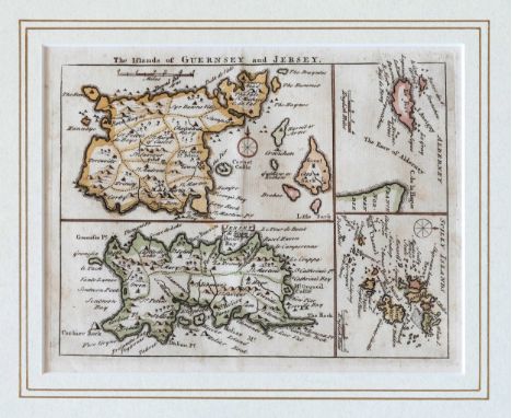
Lot 147
A late 18th century engraved map of the Channel Islands, 'A Map of the Islands of Guernsey, Jersey, Alderney & Sark situated in the English Channel, with the Sands, Rocks and Soundings', with vignette of the 'East View of Castle Cornet', c.1779, from 'The Gentleman's Magazine', probably by Thomas Kitchen, 9 3/8 x 7 1/8in. (23.8 x 18.1cm.), framed and glazed.

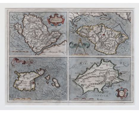
Lot 332
Gerhardus Mercator (1512-1594), Map of Jersey, Guernsey, Anglesey and the Isle of Wight, inscribed on the map of Guernsey "Per Geradum Mercatorem Cum Privilegio", published by Gerhardus Mercator in 1595, hand coloured engraving, strong impression with good margins and full plate mark, 17 3/8 x 13in. (44 x 33cm.). * From volume three of Mercator's three volume great atlas. The third volume was first published in 1595 one year after Mercator's death by his son and grandsons who were all cartographers. The plates of the atlas were later purchased by Jodocus Hondius who continued to publish the atlas from 1606 to 1619 (after 1612 by his widow and sons) followed by his son Hendricus Hondius alone and subsequently Jan Jansson.

Lot 434
Antiquarian and Later Books - Doyle (Sir Arthur Conan), Sherlock Holmes: The Complete Long Stories, first edition thus, London: John Murray, 1929, contemporary red cloth, 8vo, (1); Travel, Drummond (Henry, F.R.S.E., F.G.S.), Tropical Africa, With Map and Illustrations, London: Hodder and Stoughton, 1888, contemporary red cloth gilt, 8vo, (1); Ornithology, Johns (Rev. C.A.), British Birds in their Haunts, tenth edition, London: 1899, illustrated blue cloth, 8vo, (1); Waugh (Edwin), Lancashire Sketches, First Series, Manchester: John Heywood, [n.d.], contemporary cloth, 8vo, (1); Cochrane's English Essayists [...], Edinburgh: 1880, contemporary cloth, all-edges gilt, 8vo, (1); Black's Guide to Dorsetshire, tenth edition, 1879, green cloth, 12mo, (1); 1900 Racing Calendar, contemporary calf binding, 8vo, (1); Bunyan's Pilgrim's Progress, 19th century illustrated copy, pictorial cloth as issued, 8vo, (1); Punch 1911, contemporary cloth; further Victorian and later illustrated periodicals; folios of sheet music, mainly Beethoven; later 20th century hardback fiction and non-fiction, including John le Carré first edition, business reference; children's, including Enid Blyton and Harry Potter; large quantity

-
109182 item(s)/page