We found 109198 price guide item(s) matching your search
There are 109198 lots that match your search criteria. Subscribe now to get instant access to the full price guide service.
Click here to subscribe- List
- Grid
-
109198 item(s)/page


Lot 304
H.I. KERR, LOCH LEVEN AND GLENCOE MOUNTAINS, watercolour on paper, signed and titled, 16.5cm x 20.5cm Mounted, framed and under glass, 29.5cm x 39.5cm overall, along with a companion piece by the artist, a watercolour of a wren by Sue Quinn, a map of Hartfordshire, Orrefors glass poster and others including etchings, each framed and under glass (13)


Lot 4045
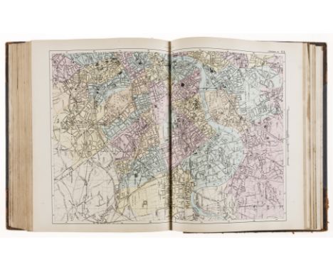
Christopher Greenwood (1786-1855) and John Greenwood (fl.1821-1840), Map of the County of Derby, from an Actual Survey made in the Years 1824 & 1825, Published by the Proprietors Greenwood & Co., 13 Regent Street, Pall Mall, London 1830, two-fold engraving, hand-coloured delineations and gradients, decorative title, the lower left-hand margin with a vignette of Chatsworth after Creighton, 58cm x 69cm

Lot 4046
Christopher Greenwood (1786-1855) and John Greenwood (fl.1821-1840), Map of the County of Derby, from an Actual Survey made in the Years 1824 & 1825, Published by the Proprietors Greenwood & Co., 13 Regent Street, Pall Mall, London 1830, two-fold engraving, hand-coloured delineations and gradients, decorative title, the lower left-hand margin with a vignette of Chatsworth after Creighton, 67.5cm x 78cm

![John Speed (1552-1629), a county map of the West Riding of Yorkshire, [London: 1627], hand-coloured engraving, 38.5cm x 52cm](https://cdn.globalauctionplatform.com/8f6ed392-12bf-406c-95f7-ad27009c49c3/f8363828-bd69-443b-92f9-ad2e00f01f6d/468x382.jpg)
![John Speed (1552-1629), a county map of Yorkshire, [London: 1676], hand-coloured engraving, 39cm x 51.5cm](https://cdn.globalauctionplatform.com/8f6ed392-12bf-406c-95f7-ad27009c49c3/c4da5559-451e-4d68-980e-ad2e00f02066/468x382.jpg)
Lot 4053
Local Interest, Derby and Derbyshire - a collection of maps and ephemera, comprising, Derby, Board of Health Map, 120in: 1 mile, engraved and a printed in colour by Bemrose 1852, originally in four sheets each of 99 x 66cm: two copies SW section, also NW and NE sections; County Borough Council, Architects? office, C. H. Aslin, CBE, Central Improvement Plan phase 2 1944 (not built), in which it was envisaged that the centre of the town would be entirely rebuilt around a new plaza on the site of the Market Place: map of intended layout of Market Place from Albert St to the Cathedral, also map of revised traffic flow in and around the town centre, of which only Traffic Street was built 95 x 98cm each; Derby map, 1815, complied from original sources and drawn on cartridge paper by Kevin Archer of Littleover, with key to locales, armorials, MS signature of the compiler with date April 2001, 55 x 76cm; Allestree Lordship map, 1727, copy drawn from the original by Kevin Archer of Littleover, cartridge paper, Mundy armorial 36 x 45cm; Facsimile map of Derby 1791 after George Moneypenny, on cartridge paper, 33 x 30 cm; Derby OS 1:2500 map 1884 edition, copies of sheets XLIX.16 (California), L.13 (Derby E), LIV.4 (Littleover and Normanton (two), LIV.8 (Sinfin), LV.1 (Peartree & Osmaston) & LV.5 (Cottons); two reproduction prints of Bemrose lithographs showing Derby from the Meadows, and Derby from Exeter Bridge, c. 1847, both printed on cartridge paper and named, each 40 x 30cm; Conduct and Proceeding of the Rebels in Derby, reproduced in facsimile from the Derby Mercury 9/12/1745, being the paper?s account of Bonnie Prince Charlie?s stay in Derby 4-6th December 1745, with other similar extracts printed in facsimile on the reverse; Ashbourne, facsimile of the 1830 map of the town by the ?pupils of Mr. Jones?s Academy? scale 44yds: 1in., with two vignettes (church and hall) 63.5 x 43.5cm; Bolsover Civic Society poster 88 x 62cm printed on cartridge paper with descriptions, plans and elevations of buildings including the Castle 1982; Egginton, map printed on cartridge paper embellished with vignettes and descriptions, drawn 1994 in aid of St. Wilfrid?s parish church at the request of Sir Henry Every, Bt., signed by the artist, 64 x 45cm; Long Eaton Hall: three copies of Erewash Borough Council drawings made in 1922 by H. Raven, Long Eaton Urban District Council surveyor when it was proposed to purchase the property as the town hall: block site plan 46 x 77cm; plans of the hall and outbuildings by H. Raven scale 8ft:1in, 100 x 70cm & east, south and west elevations of the hall 8ft: 1in H Raven 75 x 54cm; Radbourne, three plans copied from originals in the County Record Office: plan of 1711 drawn by Thomas Hand showing the previous house and immediate surroundings 84 x 59cm; copy of a plan of part of the estate, mid-18th century 42 x 29.5cm, also copy of William Emes?s map of 1790 showing his proposed alterations to the landscape 83 x 60cm; Renishaw Hall glossy poster 42 x 59cm advertising exhibition John Piper at Renishaw September 1999 with large colour print after Piper of Montegufoni (Sir George Sitwell?s Italian house); South Wingfield, facsimile of the tithe award map 1845 (DRO 13b) 86cm x 86cm; Genealogy: two hand scrivened pedigrees relating to the Tymperley family: pedigree of George Arderne and Sibyll Arderne of Tymperley, Cheshire, showing descent from Sir John Tymperley via John Chatterton, abstracted from the Heralds? Visitation of Cheshire 1580, 48 x 60cm, also pedigree of Tymperley of Hintlesham, Suffolk, abstracted from the Heralds? Visitation of Suffolk, 1664, 31 x 45cm, the latter in clear plastic carrying tube, (qty)


![William Hole (d. 1624), after Christopher Saxton (c. 1540 ? c. 1610), a county map of Derbyshire, [London: 1637], hand-colour](https://cdn.globalauctionplatform.com/8f6ed392-12bf-406c-95f7-ad27009c49c3/7eedc54f-49d6-49ad-9240-ad2e00f02798/468x382.jpg)
![William Hole (d. 1624), after Christopher Saxton (c. 1540 ? c. 1610), a county map of Northumberland, [London: 1637], hand-co](https://cdn.globalauctionplatform.com/8f6ed392-12bf-406c-95f7-ad27009c49c3/6ace3f07-b729-46a4-8223-ad2e00f028ac/468x382.jpg)
![William Kip (1588-1635), after Christopher Saxton (c. 1540 ? c. 1610), county map of Nottinghamshire, [London: 1637], hand-co](https://cdn.globalauctionplatform.com/8f6ed392-12bf-406c-95f7-ad27009c49c3/2d91378e-bce5-420f-aed2-ad2e00f02984/468x382.jpg)
![William Kip (1588-1635), after Christopher Saxton (c. 1540 ? c. 1610), county map of Staffordshire, [London: 1637], hand-colo](https://cdn.globalauctionplatform.com/8f6ed392-12bf-406c-95f7-ad27009c49c3/f8407bda-89be-42af-aba9-ad2e00f02b67/468x382.jpg)
![William Kip (1588-1635), after Christopher Saxton (c. 1540 ? c. 1610), county map of Sussex, [London: 1610], hand-coloured en](https://cdn.globalauctionplatform.com/8f6ed392-12bf-406c-95f7-ad27009c49c3/dfa5ceef-aec7-4c39-92af-ad2e00f02c58/468x382.jpg)

Lot 4113
Antiquarianism - Archaeological Pamphlets, a sammelband of six titles: The Archaeological Journal, March-September 1850, fold-out, full-page and in-text illustrations; The Ecclesiastical and Architectural Topography of England: Bedfordshire, Oxford: John Henry Parker, 1848, county map frontispiece; Winston (Charles, Esq), An Introduction to the Study of Painted Glass, With Remarks on Modern Glass Painting, Oxford: John Henry Parker, 1849; Freeman (The Rev. Philip, M.A.), Proportion in Gothic Architecture: A Paper, Read at a Meeting of The Cambridge Architectural Society, March 3, 1848, Cambridge: Published for the Society [...], 1848; [Webb (Rev. Benjamin)], An Argument for the Greek Origin of the Monogram IHS: A Paper read before the Cambridge Camden Society on Tuesday May 25 1841, With Illustrative Notes, Cambridge: At the University Press [...], 1851; On the History of Christian Altars: A Paper read before the Cambridge Camden Society, Nov. 28, 1844, second edition, London: Joseph Masters, 1847, the collection prefixed by a 19th century ink MS contents page, later 20th century blue half-morocco over red cloth, institutional gilt lettering and numbering, corresponding bookplate and some stamps, top-edge stained red, 8vo, [1] Provenance: George J. Hill, 19th century ink MS ownership inscription to some title-pages (mostly the Cambridge papers); the title-page is in his hand too.
![Cartography - Cary [(John)], Cary's New Map of England and Wales, with part of Scotland, second edition, [London]: 1816, pp:](https://cdn.globalauctionplatform.com/8f6ed392-12bf-406c-95f7-ad27009c49c3/3bd68491-3535-4dce-9922-ad2e00f0672e/468x382.jpg)

Lot 4138
Cartography - Paterson (Daniel, Esq., Assistant Quarter-Master General of His Majesty's Forces): Paterson's British Itinerary/Being A new and accurate Delineation and Descriptions of the Direct, and Principal Cross Roads of Great Britain, second edition, two-volume set, London: Printed for the Proprietors, Bowles & Carver, 1796, pp: two-page map, [3], xxxv, [1], maps 1-340, 341-403, [3] (blanks); [4] (blanks), [2], maps 404-449, 450-634, [3] blanks, contemporary mottled calf, gilt-lettered red and green morocco pieces, 8vo, (2); A New and Accurate Description of all the Direct and Principal Cross Roads in Great Britain [...], three copies: third edition, 1776, eighth edition, 1789, and tenth edition, 1794, various contemporary bindings, each with contemporaneous and/or later ownership inscriptions, 8vo, (3), [5]
Lot 4151
Franco-Spanish War, Battle of Valenciennes - Rantre (Jacques de, Licentié és Loix, Advocat, & du Conseil particulier de la ditte ville), Description veritable des choses plus memorables arrivées pendant le siège de la ville de Valentiennes fait par l'Armée de France [...], Valentiennes [Valenciennes]: Jean Boucher, 1656, pp: [viii], 144 (signatures K & L transposed), marginal fragment of the called for map before signature A, foliate intials, modern calf in imitation of a 17th century binding, red-speckled edges, 4to, [1] Provenance: Joseph Maillart (1643-1717), abbé de Clairmarias (1688-1717), a former Cistercian house at Clairmarias, Pas-de-Calais, Hauts-de-France, France, later 17th/early 18th century engraved bookplate and associated contemporary ink MS inscription to front free endpaper. Rare work, of which only 3 copies are reported in the collective catalogue of libraries in France, including that of the BM. de Valenciennes which appears to be a variant issue. A previous copy, sold at Kâ-Mondo, Hotel Drouot, Paris, Collections de M. et Mme G., et à divers : Instruments Scientifiques, Livres Anciens et Modernes, Reliures de Napoléon, Numismatique, 20th May, 2015, Lot 335.
![Germany, Saxony, History and Antiquities - Abel (Caspar), Teutsche und Sächsische Alterthümer [...], two-volume set bound as](https://cdn.globalauctionplatform.com/8f6ed392-12bf-406c-95f7-ad27009c49c3/08a8c3a8-f2cf-424b-81d5-ad2e00f0741f/468x382.jpg)
Lot 4152
Germany, Saxony, History and Antiquities - Abel (Caspar), Teutsche und Sächsische Alterthümer [...], two-volume set bound as one, Braunschweig [Brunswick]: L. Schröders, 1729-1730, pp: [2] (blank), frontispiece panorama, [xiv], 512; allegorical map frontispiece, [xiv], 736, [2] (blank), foliate initials, Baroque woodcut still life ornamental footers, rebacked and relayed spine over contemporary calf boards, red-specked edges, 8vo, [1]Provenance: 1) Johannes Holtmann, 19th century blue ownership stamp to first title-page; 2) Liverpool Free Public Library, blind-blocked lower-cover and their bookplate to recto pastedown.
Lot 4184
Miscellaneous - Travel, Jephson (John Mounteney, F.S.A.), Narrative of a Walking Tour in Brittany, first and only edition, London: Lovell Reeve, 1859, fold-out map, lacking stereograph frontispiece, not accompanied by the set of stereographs which were separately sold, contemporary cloth, 8vo, (1); Beaton (Cecil), Chinese Album, first edition, London: Batsford, Winter, 1945-46, b/w illustrations, pictorial dustjacket over yellow cloth, 8vo, &, Near East, second printing, first edition, London: Summer, 1943, pictorial dustjacket over red cloth, 8vo, (2); The Beauties of the Bosphorus, one separate volume composed of pages 79-164, illustrated with 40 full-page steel engravings and 1 map, contemporary quarter-morocco gilt (rubbed, chipped), 4to, (1); Hacker (Louis M.), The Shaping of the American Tradition, two-volume set, first trade edition, Columbia University Press: 1947, cloth, 8vo, (2); Boughton (George H., A.R.A.), Sketching Rambles in Holland, London: 1885, illustrated, pictorial red cloth, 4to, (1); Howitt (William), Homes and Haunts of the Most Eminent British Poets, two-volume set, second edition, London: 1847, contemporary printed boards, all-edges gilt, 8vo, (2); Seymour's Humorous Sketches, London: [1878], pictorial cloth, 8vo, (1); The Bystander, January to June 1916, in two contemporary cloth binders, folio, (2); Seven Pillars of Wisdom, first public edition, London: 1935, cloth, 4to, (1); another copy, third impression, London: August, 1935, cloth, 4to, (1); Stoddard's Portfolio of Photographs, Chicago: The Werner Company, [n.d.], b/w plates, cloth, oblong 4to, (1); Wallace's Photographic Gems of Art, Springfield: 1896, cloth, oblong 4to, (1); Romany/Gypsy; British East Africa; Ethiopia; Dickens; etc., [32]
![Travel and Exploration - Egypt, Lane (Edward William), An Account of the Manners and Customs of the Modern Egyptians [...], f](https://cdn.globalauctionplatform.com/8f6ed392-12bf-406c-95f7-ad27009c49c3/b8c4ebba-06ca-454a-9d54-ad2e00f0a106/468x382.jpg)
Lot 4205
Travel and Exploration - Egypt, Lane (Edward William), An Account of the Manners and Customs of the Modern Egyptians [...], first edition thus, two-volume set, London: Charles Knight and Co., 1836-1837, b/w plates and in-text illustrations, some music, contemporary cloth, 8vo, 19th century church and seminary stamps, 8vo, (2); Prescott (William H.), History of the Conquest of Mexico, three-volume set, second edition, London: Richard Bentley, 1844, titles printed in red and black, portrait frontispieces, maps and plates, contemporary cloth, 8vo, (3); The Continental Tourist; Belgium & Nassau, London: Parry & Co., [n.d., c. 1845], illustrated with 32 steel engravings and a fold-out map, contemporary green cloth (chipped spine), 8vo, (1); Wood (Charles W.), In the Valley of the Rhone, London: 1899, green cloth gilt, 8vo, (1), [7]
Lot 4211
Scotland - Hydraulic Engineering, Glasgow Water Works, a Victorian sammelband of four monographs &/or tracts: Gale (James M.), The Glasgow Water Works: Papers Read During the Session 1863-64 [...], Glasgow: Printed by Bell & Bain, 1864, 56pp, additional lithograph title-page, 1 fold-out map and 3 fold-out charts; Glasgow Loch Katrine Waterworks, Banquet to Mr. Bateman [...], Westminster: Vacher & Sons, 1860, 47pp; a further sequence of six connected papers from a periodical, lacking title-page and a contents, paginated from [121]-266 and illustrated with 52 full-page engineering plates; Gale (Mr. James, C.E.), On the Port-Glasgow Water Works [...], Glasgow: William Munro, 1868, 8pp and 4 fold-out plates, contemporary half-morocco over moiré boards, red-stained edges, 8vo, (1); Sinclair (Catherine), Sketches and Stories of Scotland and the Scotch, With Corrections and Additions, London: Simpkin, Marshall, and Co., [n.d. 1868], contemporary three-quarter calf, marbled edges, 12mo, (1); Beeton's Dictionary of Useful Information [...], two-volume set, London: S.O. Beeton, [1859], volume I with fold-out chromolithograph chart, further b/w fold-out charts and plates, in-text illustrations, contemporary green quarter-calf, marbled edges and endpapers, 8vo, (2); The National Encyclopædia [...], volume I only, London: [n.d.], 8vo, (1), [5]


Lot 258
Late 18th/early 19th Century silkwork sampler, worked with a map of England and Wales and vignette of Britannia on shoreline with sailing ship, within floral border, 57cm x 49cm, framed and glazed.Condition report: Condition: Some water stains top right and bottom fifth extending into English Channel, minor stitching loss. A few small tears and losses to silk ground around edges visible under close inspection.Due to ongoing Covid restrictions, bidders are able to view lots in this online-only sale on the specified viewing days, by prior appointment only. There is no viewing on the day of sale. Please therefore read the following:As this is a sale of second-hand and antique items, bidders should expect items to exhibit general wear and tear commensurate with age and use unless otherwise stated. Please carefully examine the images as they form part of the overall condition. Clevedon Salerooms are happy to provide further detailed information on request, if received by email or telephone at least 24 hours prior to the sale. The mention of a specific flaw or fault does not automatically mean that no other faults exist. Reports are provided as a goodwill gesture and are a general assessment, not a forensic survey.Further category-specific condition information can be found in our Standard Terms and Conditions. The placing of a bid by you is taken by us as an indication that you have read, understood and agreed to these terms.

Lot 372
Collins, Captain Greenvile, (1643-1694); late 17th Century hand-coloured map, 'Plymouth', dedicated to the Rt. Hon'ble. Arthur Earle of Torrington, Baron Herbert of Torbay, 44.5cm x 56cm, framed and glazed, and Sayer, Robert, 'Plymouth Sound, Hamoaze and Catwater Surveyed in 1786', 69cm x 51cm, in similar frame under glass, (2)Condition report: 1st - light brown staining, mianly noticeable to margins and a little to estuary.2nd - Light foxing, a little vertical rippling.


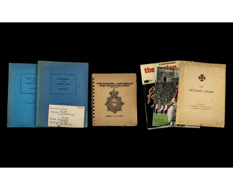
Lot 1384
Military Interest - Collection of Military Books, comprising: The Concise Lineages of the Canadian Army 1855 to Date; The Victoria Cross Centenary Exhibition; The Tartan Map; The Royal Welsh Fusiliers; Headdresses of the British Army - Yeomanry; and Headdresses of the British Army - Cavalry.


Lot 225
A 19th century Cruchley's terrestrial 6 inch globe, Cruchley's New Terrestrial Globe, Showing The Latest Discoveries Settlements & C. in Australia New Zealand, California & The North Pole C F Cruchley, Map Seller Globe Maker & Publisher 81 Fleet Street London (Additions to 1862 XVI), on a turned wood stand, 25 cm highFrom a local deceased estate, bought by the client in a restored state, with a quite a lot of restoration as is often the case, the wooden base could do with a re polish


Lot 313
A 17th century Gerard Mercator engraved map of South East England, 'Warwicum, Northamtonia, Huntingdonia, Cantabrigia, Suffolcia, Oxonium, Buckinghamia, Bedfordia, Hartfordia, Essexia, Berceria, Middlesexia, Southhatonia, Surria, Cantii & Southsexia', paper label verso for Artlynck Gallery, 37cm by 47cm

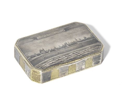
Lot 120
A Parcel-gilt Silver and Niello Cartographic Boxmark of Feodor Bushkovskii, Velikii Ustiug, 1822rectangular with cut corners, the hinged cover with a niello panoramic view of Velikii Ustiug seen from the left bank of the river Sukhona, with a Russian descriptive banner above, the reverse nielloed with a map of the Vologda region on stippled gilt ground, with keys, scale and distance chart, the sides with coat-of-arms of Vologda region, bright-cut rims on the cover and sides, gilt interior, 84 standard length: 9cm (3 9/16in); width: 6.3cm (2 1/2in). Footnotes:ProvenanceChristie's, London, anonymous sale, 9 June 2009, lot 138Acquired at the above by the previous ownerPrivate collection, UKThence by succession to the present ownerFor comparable silver-gilt and niello cartographic cases, see A. von Solodkov, Russian Gold and Silver, Fribourg, 1981, pp. 106-107, nos. 116-120.For further information on this lot please visit Bonhams.com

Lot 106
South America.- Maw (Henry Lister) Journal of a Passage from the Pacific to the Atlantic...and descending the River Marañon, or Amazon, first edition, folding engraved map of the Amazon, offsetting, stained, antique style dark green half calf, gilt, spine in compartments, [Howgego p.396; Sabin 46988; Hill 1115], 8vo, John Murray, 1829. ⁂ 'Rich in facts relating to the condition, history and character of the Indians of Peru and Brazil, particularly of the unexplored districts in the valley of the Marañon or upper Amazon' (Hill).
Lot 108
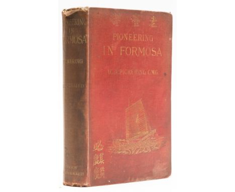
Taiwan.- Pickering (William Alexander) Pioneering in Formosa: Recollections of Adventures among Mandarins, Wreckers, & Head-Hunting Savages, first edition, presentation inscription by author, half-title, portrait frontispiece, 23 plates, 1 map, advertisements at end, occasional spotting, cracked hinge, original decorative cloth, gilt, rubbed, bumping to corners and extremities, 8vo, 1898.⁂ Pickering worked as a tidewaiter for the Chinese Imperial Maritime Customs office in Fuzhou and Formosa (now Taiwan) in the 1860s and learnt the local dialect. In 1877 he was appointed as the first Protector to administer the Chinese Protectorate in colonial Singapore. Speaking both Mandarin and Hokkien, the first European in Singapore to do so, he managed to keep the secret societies under control, maintaining authority and subduing unrest by playing his bagpipes in the street.
Lot 119
NO RESERVE West Indies.- Bermuda.- Britton (Nathaniel, Lord) Flora of Bermuda, first edition, coloured frontispiece, illustrations, ink gift inscription, original cloth, spine heavily sunned, extremities lightly scuffed, 1918 § Gipson (Henry Clay) Bermuda, 24 plates, map, original printed covers, scroll bound, preserved in original pictorial box, flaps and corners worn, 1937 § Dorr (Julia) An Idyl of the Summer Islands, folding colour map, ink ownership inscription to front endpaper, water staining to upper margin throughout, original pictorial cloth, small stain to upper cover, a little rubbed, 1886; and 3 others, all relating to Bermuda, v.s. (6)
Lot 122
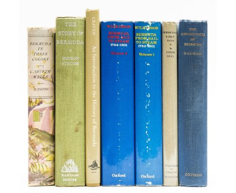
NO RESERVE West Indies.- Bermuda.- Wilkinson (Henry) The Adventurers of Bermuda, large folding map in pocket at rear, one small tear at fold, plates, original pictorial cloth, 1933; Bermuda from Sail to Steam, 2 vol., large folding map, plain plates and illustrations, bookplates to front endpapers, original cloth, dust-jackets, lightly scuffed, 1973 § Heyl (Edith) Bermuda's Early Days, frontispiece and illustrations, original cloth, lightly damp-stained, dust-jacket, spine sunned, 1959; and 3 others, all relating to Bermuda, v.s. (6)
Lot 124
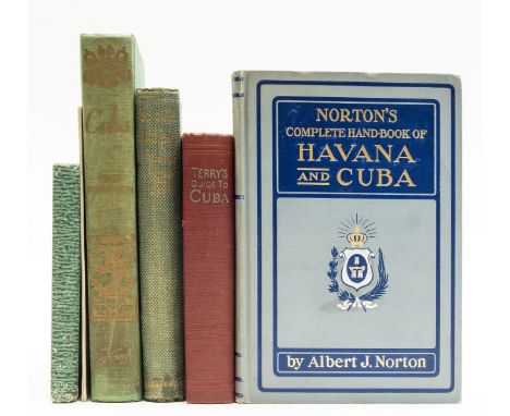
NO RESERVE West Indies.- Cuba.- Terry (T.Philip) Terry's Guide to Cuba, 9 maps and plans, some folding, endpapers browned, 1926 § Dana (Richard Henry) To Cuba and Back, first edition, some soiling and spotting to initial pages, spine slightly sunned, 1859 § Norton (Albert) The Complete Handbook of Havana and Cuba, plain plates, lacking folding map, 1900, all original cloth, the last pictorial and gilt lettered; and 3 others, relating to Cuba, v.s. (6)
Lot 128
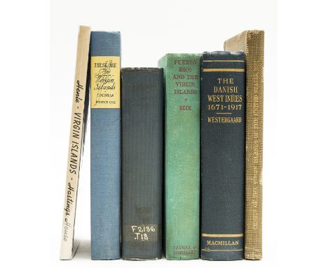
NO RESERVE West Indies.- Virgin Islands.- Hartley (Eugene) Census of the Virgin Islands of the United States 1917, very occasional spotting, 1918 § Westergaard (Waldemar) The Danish West Indies, folding map, title lightly foxed, 1917 § Reck (Daisy) Puerto Rico and the Virgin Islands, occasional foxing, upper hinge cracked, 1939, all with plain plates, original cloth, some staining to covers and light scuffing or bumping to extremities; and 3 others, Virgin Islands, v.s. (6) ⁂ The first very scarce and the second scarce in this condition.
Lot 129
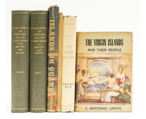
NO RESERVE West Indies.- Virgin Islands.- Jarvis (J. Antonio) The Virgin Islands And Their People, illustrated frontispiece, plates, some light foxing, original boards, small abrasions to spine foot, spine a little bumped, dust-jacket, covers toned, some small holes to spine, 1944 § Evans (Luther H.) The Virgin Islands, From Naval Base to New Deal, frontispiece map, library stamps, original cloth, dust-jacket, some light soiling and chipping, tear to upper cover and lower joint, 1945 § New York Academy of Sciences. Scientific Survey of Porto Rico and the Virgin Islands, volume V [-VI], Botany of Porto Rico and the Virgin Islands, 2 vol., library cloth, 1924 [-30]; and 2 others, Virgin Islands, v.s. (5) ⁂ The first two very scarce.
Lot 131
NO RESERVE World.- A Series of Maps, Modern and Ancient ... under the supervision of the Society for the Diffusion of Useful Knowledge, 61 hand-coloured engraved maps, some duplicates, many with tissue repairs, contents leaf with large loss (tissue repairs), original paper wrappers to several parts, many laid down on tissue or linen, loss to edges, disbound, Charles Knight, 1845-47; The Stars in Six Maps, 6 hand-coloured maps, tissue repairs, loss to title foot affecting imprint, [Charles Knight], n.d., ex-library with labels to map verso, occasional blind-stamps, occasional pencil and ink annotations to covers, housed in a modern drop-back box, small label to spine, slight bumping to corners, folio; sold as a series of maps, not subject to return

Lot 139
NO RESERVE *** Please note, the description for this lot has changed ***Britain.- Jerrold (Walter) The Silvery Thames, one of 200 copies of the de luxe edition, signed by the author and illustrator, colour tipped-in plates by Haslehust, endpapers lightly spotted and frayed, original half vellum, rubbed, spine faded, 1906 § Jenkinson (Wilberforce) London Churches Before the Great Fire, plates, endpapers browned, original buckram, gilt, dust-jacket, lightly marked and chipped to extremities, 1917 § Tomlins (Thomas Edlyne) A Perambulation of Islington, lacking folding map, original cloth-backed buckram, lightly marked and corners bumped, 1858; and c.40 others, mostly London and some other British topography, v.s. (c.40)⁂ Second is rare to find in dust-jacket.*** Please note, the description for this lot has changed *** Britain.- Jerrold (Walter) The Silvery Thames, one of 200 copies of the de luxe edition, signed by the author and illustrator, colour tipped-in plates by Haslehust, endpapers lightly spotted and frayed, original half vellum, rubbed, spine faded, 1906 § Jenkinson (Wilberforce) London Churches Before the Great Fire, plates, endpapers browned, original buckram, gilt, dust-jacket, lightly marked and chipped to extremities, 1917 § Tomlins (Thomas Edlyne) A Perambulation of Islington, lacking folding map, original cloth-backed buckram, lightly marked and corners bumped, 1858; and c.40 others, mostly London and some other British topography, v.s. (c.40)
Lot 14
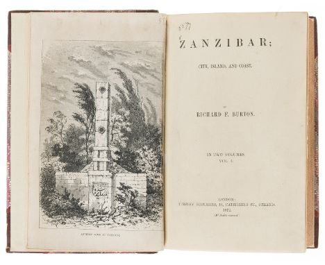
Africa.- Burton (Sir Richard Francis) Zanzibar; City, Island and Coast, 2 vol., first edition, half-titles, wood engraved frontispieces and 9 plates, large folding map, short tear with neat repair, 4 route maps, frontispieces, titles and final leaves all laid down, one or two neat marginal pencil notes, occasional faint blind-stamps, occasional faint spotting, near contemporary half-morocco, rebacked with original spine laid down, [Penzer pp.88-89], 8vo, 1872.
Lot 149
Atlases.- Britain.- Bacon (G. W.) New Large-Scale Atlas of the British Isles, 103 maps or plans with contemporary hand-colouring, one map detached and frayed at margin but not affecting image, some light spotting to first few pp., contemporary half calf, gilt, calf worn with joints splitting, folio, G. W. Bacon, 1892.
Lot 15
Africa.- Cagnolo (Fr. C.) The Akikuyu: Their Customs, Traditions and Folklore, first edition, half-title, frontispiece, folding map at end, plates, of which 2 colour, small abrasion marks to one or two plates, illustrations, occasional spotting, previous owner's ink inscription to half-title, original cloth, rebacked with original spine laid down, slight bumping to corners, [Hosken p.37], Kenya, 1933 § Burrows (Capt. Guy) The Land of the Pigmies, portrait frontispiece, illustrations, many full-page, occasional faint spotting, previous owner's signatures to front free endpaper, bookplate, cracked hinges, original decorative cloth, gilt, slight bumping to corners and extremities, [Hosken p.33], 1898; and others similar, 8vo (8)⁂ The second with the bookplate of I. & F.W. Hosken, authors of "A Catalogue of Books on Africa mainly south of the equator".
Lot 150
Atlases.- England and Wales.- Cruchley (George Frederick) Railway & Station Map of England and Wales, engraved double-page title and 66 double-page maps with bright hand-colouring, nicks and tears, some tears torn and repaired, some light marginal toning and surface dirt, title working loose but reinforced with paper support verso, contemporary half calf, rubbed, folio, [c.1879.]

Lot 159
Africa.- Jansson (Jan) Fezzae et Marocchi Regna Africae, map of Morocco, including the Straits of Gibraltar, with north oriented to the right, engraving with early hand-colouring on laid paper without watermark, platemark 385 x 500 mm (15 1/8 x 19 3/4 in), full margins, blank verso, central vertical fold with small loss to foot, some spotting and surface dirt, minor handling creases, unframed, [circa 1650]; together with a good group of 16 other maps of Africa, including Sanson and Mortier's 'Antiquorum Africae Episcpatuum Geographica Descriptio', two hand-coloured impressions of Ortelius's half-sheet map 'Aegypti Recentior Descriptio', a damaged example of Blome's 'A Generall Mapp of the Coast of Barbarie', and others by d'Anville, two impressions of Mount and Page's chart 'A Chart of ye Coast of Barbary from Cape Geer to Cape Bajadore', and others, engravings, various sizes, all unframed, mainly [18th and 19th century] (17)
-
109198 item(s)/page