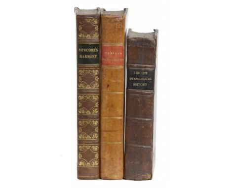

DU PIN, LOUIS ELLIES - THE EVANGELICAL HISTORY: The Life of our Blessed Saviour Jesus Christ, Comprehensively and Plainly Related [Bound together with] THE LIVES AND ACTS OF THE HOLY APOSTLES London, Abel Swall and T Child, 1696. Two volumes bound in one, 8vo, both with separate pagination and title pages dated 1696, first work with engraved frontispiece and other engravings, second with folding map and full-page engravings of the Apostles, full contemporary panelled calf. ESTC R31386 and R212958 respectively, scarce - in N America ESTC lists 2 locations for the 1st work and 1 location for the 2nd; NEWCOME, WILLIAM [ARCHBISHOP OF ARMAGH] - AN ENGLISH HARMONY OF THE FOUR EVANGELISTS disposed after the Manner of the Greek. London, Samuel Bagster, 1827. 8vo, scarce edition, folding hand-coloured map of the Holy Land, contemporary quarter calf with marbled boards; HERVEY, JAMES - MEDITATIONS AND CONTEMPLATIONS Glasgow, Khull, Blackie, & Co, 1821. 8vo, engraved portrait frontispiece plus other engravings (some browning/offsetting), full contemporary tree-calf. This Glasgow printing is scarce (3)++DU PIN - lower margin of T3 repaired not affecting text, partial leaves from an earlier (16th century?) latin work used as pastedowns. NEWCOME - folding map with slight spotting and offsetting to title, top of title with early 19th c ink signature HERVEY - some plate spotting/offsetting
We found 109182 price guide item(s) matching your search
There are 109182 lots that match your search criteria. Subscribe now to get instant access to the full price guide service.
Click here to subscribe- List
- Grid
-
109182 item(s)/page

PENNANT, THOMAS - A JOURNEY FROM CHESTER TO LONDON London, Wilkie and Robinson, 1811. 8vo, frontispiece and 5 engraved plates complete as issued, full contemporary gilt-panelled diced calf, attractively re-backed; WARD, HARRIET - THE CAPE AND THE KAFFIRS A Diary of Five Years Residence in Kaffirland; with a Chapter of Advice to Emigrants, based on the latest official returns, and the most Recent Information Regarding the Colony. London, Henry G Bohn, 1851. Third edition, 8vo, engraved frontispiece showing the passage of troops across the Tyumie, folding map of the 'Present War in Kaffirland' dated 1851, signature excised from top of title, late 19th century cloth boards and calf spine (2)++PENNANT - a little browned with some plate offsetting, attractive binding WARD - top of title cut away (signature excised), front-free end-paper removed, spine with paper label
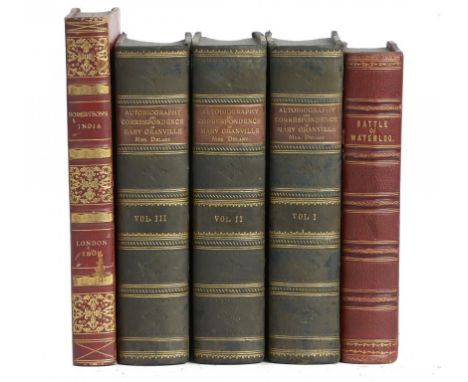
THE BATTLE OF WATERLOO; OR, A FAITHFUL AND INTERESTING HISTORY OF THE UNPARALLELED EVENTS... From the period of Bonaparte's escape from Elba, to his arrival at St. Helena: containing a circumstantial narrative of the decisive victory... on the Plains of Waterloo, June 18, 1815. Manchester, J Gleave, 1816. Second Edition, 8vo, folding engraved and hand-coloured map, engraved frontispiece and additional engraved title, folding hand-coloured engraving of the 'Plains of Waterloo', plus other engravings, foxed throughout as usual, 19th century quarter red morocco with red cloth boards. This second-edition 1816 Manchester imprint is scarce; LLANOVER, LADY & GRANVILLE, MARY - THE AUTOBIOGRAPHY AND CORRESPONDENCE OF MARY GRANVILLE, Mrs. Delaney, With Interesting Reminiscences of King George the Third and Queen Charlotte. London, Richard Bentley, 1861. First edition, 3 volumes, 8vo, engraved plates, attractive 19th century bindings by L A Smart of Gloucester of green calf with marbled boards and brown morocco labels; ROBERTSON, WILLIAM - AN HISTORICAL DISQUISITION CONCERNING THE KNOWLEDGE WHICH THE ANCIENTS HAD OF INDIA; and the Progress of Trade with that country prior to the Discovery of the Passage to it by the Cape of Good Hope. London, Cadell & Davies, 1809. Fifth edition, 8vo, 2 folding maps (tears along folds), foxing throughout, attractively bound in 19th century red calf with paper boards, spine gilt (5)++WATERLOO - heavy foxing due to paper quality (as usual), small hole in leaf 2D, one plate with repairs to verso of folds not affecting image, binding sound, cloth boards with staining but leather spine good GRANVILLE - good, and attractively bound ROBERTSON, tears to folds of maps, heavy foxing throughout, attractive binding with a little wear
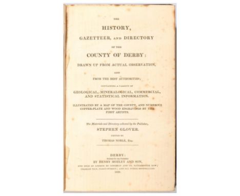
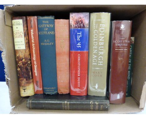
GLOVER, STEPHEN - THE HISTORY, GAZETTEER, AND DIRECTORY OF THE COUNTY OF DERBY drawn up from actual Observation, and from the best Authorities; containing a Variety of Geological, Mineralogical, Commercial and Statistical Information. Edited by Thomas Noble. Derby, Henry Mozley and Son, 1829 & 1833. First edition, two volumes (complete), 8vo, volume 1 part 1 published 1829, volume 2 part 1 published 1833, folding map (often missing), plates, illustrations in text, publisher's cloth with printed paper labels; and 6 other 19thC volumes w.a.f. (8)++As described and sold w.a.f.
[NAPOLEON BONAPARTE INTEREST] - A COLLECTION OF 20 VOLUMES about, or relating to, Napoleon, including; GOURGAUD, GENERAL - THE CAMPAIGN OF MDCCCXV Or a narrative of the Military Operations...in France and Belgium during The Hundred Days, written at St Helena. London, James Ridgway, 1818. First edition, 8vo, folding hand-coloured map of the military operations in Flanders, 4 folding tables as called-for, original blue boards and paper spine (split), upper board detached; RICHARDSON, ETHEL M - LONG FORGOTTEN DAYS (LEADING TO WATERLOO). London, Heath Cranton, 1928. First edition, 8vo, cloth; MACUNN, F J - THE CONTEMPORARY ENGLISH VIEW OF NAPOLEON. London, G Bell & Sons, 1914. First edition, 8vo, blue cloth; and 17 others mainly early 20thC (20)++Condition varies
LANZI, LUIGI & ROSCOE, THOMAS [TRANSLATOR] - THE HISTORY OF PAINTING IN ITALY From The Period Of The Revival Of The Fine Arts To The End Of The Eighteenth Century. London, Simpkin & Marshall, 1828. First edition of this translation, 6 volumes, 8vo, original grey boards, cloth spines, and paper labels (labels badly worn, spines soiled, inner hinges split); SHEPHERD, C W - THE NORTH-WEST PENINSULA OF ICELAND London, Longmans, 1867. First edition, 8vo, folding map and 2 coloured plates, very good in original green publisher's cloth; BURGESS, JAMES W - A PRACTICAL TREATISE ON COACH-BUILDING London, Crosby Lockwood and Co, 1881. 12mo, illustrations in text, publisher's cloth, lacks front free end-paper; BELL, J MUNRO & HAYDEN, ARTHUR - THE FURNITURE DESIGNS OF THOMAS CHIPPENDALE London, Gibbings and Co, 1910. First edition, large 4to, plates, publisher's cloth; LAWRENCE, T E - SEVEN PILLARS OF WISDOM, London, Cape, 1935. Fifth impression, 4to, dust-wrapper (with repairs); and circa 34 other volumes/pamphlets relating to archaeology and antiquities, mainly early 20th century, w.a.f. (circa 44) ++As described, sold w.a.f.
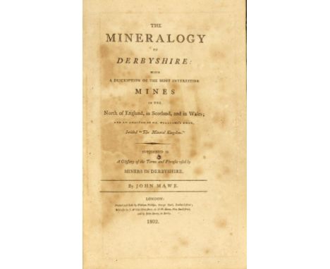
MAWE, JOHN - THE MINERALOGY OF DERBYSHIRE with a description of the most interesting mines in the North of England, in Scotland, and in Wales; and an analysis of Mr William's work intitled The Mineral Kingdom. London, William Phillips, 1802. First edition, 8vo, frontispiece, map, and two other plates (complete), quarter calf, boards detached, some browning/offsetting. Scarce++Both boards detached, title browned, offsetting of plates, toning, final leaf torn in inner margin not affecting text, requiring a re-bind
GREENWOOD, C & J - ATLAS OF THE COUNTIES OF ENGLAND FROM ACTUAL SURVEYS MADE FROM THE YEARS 1817 TO 1833 London, Greenwood & Co, 1834. First edition, elephant folio, engraved title page with hand-coloured map of England and Wales showing the counties which are contained in the atlas as well as the major towns in each county, forty-six coloured double-page maps (including the title), maps of Wales at the rear, maps generally good clean and fresh with occasional slight offsetting of engraved areas, original quarter diced-calf, upper board detached++maps generally clean and fresh, original quarter diced-calf, upper board detached
![MOLL (HERMAN) A NEW MAP OF GREAT BRITAIN [1719] on two sheets joined, hand coloured, mounted to frame line, 102.5 x 62cm++Fol](https://cdn.globalauctionplatform.com/ef9e6eaa-7d8b-4f64-8216-a8ce011940aa/62e31b68-7dec-4789-9f18-0aafecd90ab0/468x382.jpg)
STAVELEY (E) AND H M WOOD PLAN OF THE TOWN AND COUNTY OF THE TOWN OF NOTTINGHAM... 1830 engraved wall map and vignette of Nottingham Castle, backed on linen, wooden roller, 122 x 120cm, a 19th c O.S. sheet map of Eastwood, Notts, hand coloured and an early 19th c O.S. wall map of Eastern England (Notts and Lincs) (3)++Typical tears, peripheral soiling/handling marks/creases


NEELE - LONDON AND WESTMINSTER IN THE REIGN OF QUEEN ELIZABETH ANNO DOM 1563 engraving, hand coloured, slightly soiled, mounted to within platemark, 21 x 55cm, a map of Northamptonshire by Robert Morden, hand coloured engraving of the cities of London and Westminster accurately copied from the table of the camera obscura in the Royal Observatory at Greenwich 1804 and two maps of the coast of Cape d Verde and map of chart of the Cape d Verde islands by T Kitchen, 1744, hand coloured (5)++++


SPEEDE (JOHN) FIVE ENGLISH COUNTY MAPS comprising Cumberland, Northumberland, the West Riding of Yorkshire, the North and East Ridings of Yorkshire and Durham, double page engravings from the Theatre, 17th or 18th c (edition unascertained), uncoloured, generally browned, mounted to within platemark, 38.5 x 51.5cm & c, framed as a set and a map of Derbyshire by Robert Morden (6)++++
CARY, JOHN - CARY'S NEW MAP OF ENGLAND AND WALES WITH PART OF SCOTLAND on which are carefully laid down all the Principal Cross Roads, the Course of the Rivers and Navigable Canals, Cities. London, J Cary, 1794. First edition, 4to, maps with original outline hand-colouring, lacking sheets 62/63 71/72 and 80 as often (62 and 80 are blanks), in an unusual contemporary wallet-style brown calf binding over limp boards, presumably made for travelling purposes. Housed in a modern solander box++Lacking sheets 62-63 71-72 and 80 (62 and 80 are blanks), in an unusual contemporary wallet-style brown calf binding over limp boards, presumably made for travelling purposes. Housed in a modern solander box. Maps clean and fresh with just occasional light marks/soiling, leather rubbed/worn with small calf loss to lower board

CARY, JOHN - CARY'S SURVEY OF THE HIGH ROADS FROM LONDON London, J Cary, 1801. Small folio, engraved title-page and explanation leaf, folding engraved general map of London and environs, full-page general plan for explaining the different trusts of the turnpike gates, 80 fine engraved strip-maps on 40 plates all with original hand-colouring, calf, re-backed++Internally good, original calf boards with new spine and inner hinges reinforced


![[DERBYSHIRE INTEREST] - GOODACRE, J. A. - BUXTON OLD AND NEW a study of its Rise and Growth during Two Thousand Years. Buxton](https://cdn.globalauctionplatform.com/ef9e6eaa-7d8b-4f64-8216-a8ce011940aa/5e12074e-16a1-41e7-bf71-6d2cdea0d0e1/468x382.jpg)
[DERBYSHIRE INTEREST] - GOODACRE, J. A. - BUXTON OLD AND NEW a study of its Rise and Growth during Two Thousand Years. Buxton, J A Goodacre, 1928. Limited Edition number 94 of 550 copies, folio, beautifully printed throughout and with 108 original drawings, red capitals, folding map, original brown cloth. A fascinating history of Buxton from Roman times to the 1920s, with drawings of antiquities and monuments as well as early 20th century buildings etc. Scarce ++Occasional faint spotting but good, corners of boards bumped, slight wear to top and bottom of spine
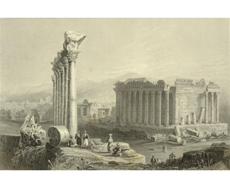
CARNE, JOHN - SYRIA, THE HOLY LAND, ASIA MINOR... Illustrated. In a series of views drawn from nature by W.H. Bartlett, William Purser, [and Thomas Allom]. London, Fisher, Son & Co, 1836-1838. First edition, 3 volumes, 4to, fine steel-engraved views, some foxing, half black calf with new spine labels; HUTCHINSON, LUCY - MEMOIRS OF THE LIFE OF COLONEL HUTCHINSON, GOVERNOR OF NOTTINGHAM CASTLE AND TOWN. London, Longman, 1806. First edition, 4to, plates, title browned, green morocco leather; SUE, EUGENE - THE MYSTERIES OF PARIS. London, Chapman and Hall, 1845-1846. First edition in English, three volumes, royal 8vo, illustrated in text throughout, handsomely bound in later half red morocco leather, spines gilt, a nice set of this very popular novel on the poor and lower classes of Paris; BRASSEY, LADY ANNIE - THE LAST VOYAGE TO INDIA AND AUSTRALIA IN THE 'SUNBEAM'. London, Longmans, 1889. First edition, 8vo, presentation copy from Thomas Brassey (Earl Brassey) the husband of the author, inscribed "Lady Burton from Brassey, In Memoriam", full-page plates, map, and other illustrations, half red calf, rubbed (8) ++as described
WHITBY, DANIEL - A PARAPHRASE AND COMMENTARY ON THE NEW TESTAMENT London, W Bowyer, 1709/1710. Third edition, two volumes, folio, engraved portrait frontispiece, folding map (bound in volume 1), panelled calf, worn, joints cracked; PEARSON, JOHN - AN EXPOSITION OF THE CREED London, John Williams, 1676. Fourth edition, folio, engraved portrait frontispiece, title ruled in red, contemporary reversed calf; BOOK OF COMMON PRAYER Oxford, 1784. 4to, reversed calf, worn, upper joint cracked; BOOK OF COMMON PRAYER Oxford, Thomas Baskett, 1758 (5)++As described, request condition on specific volumes
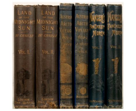
CHAILLU, PAUL B DE - LAND OF THE MIDNIGHT SUN: SUMMER AND WINTER JOURNEYS THROUGH SWEDEN, NORWAY, LAPLAND AND NORTHERN FINLAND With descriptions of the Inner Life of the People, their Manners and Customs, the Primitive Antiquities etc. London, John Murray, 1881. First English edition, 2 volumes, 8vo, illustrations, folding coloured map in pocket at rear (some tears along folds, but the map is often missing), pictorial cloth, rubbed, some wear and spots; PAYER, JULIUS - NEW LANDS WITHIN THE ARCTIC CIRCLE Narrative of the Discoveries of the Austrian Ship "Tegetthoff" in the Years 1872-1874. London, Macmillan, 1876. First English edition, 2 volumes, 8vo, coloured frontispiece, profusely illustrated, two double-page maps, blue gilt cloth, spines faded, wear to extremities; NANSEN, FRIDTJOF - FARTHEST NORTH Being the record of a Voyage of Exploration of the Ship Fram 1893-96 and of a Fifteen Months' Sleigh Journey by Dr. Nansen and Lieut. Johansen. London, George Newnes, 1898. First English edition, two volumes, 8vo, colour plate and numerous black and white plates, map mostly missing, publisher's cloth, upper boards badly stained (6)
![[BREECHES / GENEVA BIBLE] - THE BIBLE, that is, the holy Scriptures conteined in the Olde and Newe Testament, translated acco](https://cdn.globalauctionplatform.com/ef9e6eaa-7d8b-4f64-8216-a8ce011940aa/358fb0d4-2709-4c3b-bf57-fb9ad902b7a6/468x382.jpg)
[BREECHES / GENEVA BIBLE] - THE BIBLE, that is, the holy Scriptures conteined in the Olde and Newe Testament, translated according to the Ebrew and Greeke, and conferred with the best translations in divers languages. With most profitable Annotations upon all the hard places, and other things of great importance. London, by the Deputies of Christopher Barker, Printer to the Queenes most excellent Majestie, 1599 [bound with] THE NEW TESTAMENT...Englished by L Tomson. London, Christopher Barker, 1599. 4to, engraved pictorial general title page with title within heart shaped centre enclosed by block border with symbols of the twelve tribes to the left, the twelve apostles to the right and an evangelist at each inner corner, Matthew and Mark above, Luke and John below, general letterpress title with small woodcut of Crossing the Red Sea, dated 1599, divisional title page to Second Part of Old Testament but without imprint, New Testament engraved title page with same border of tribes and apostles, dated 1599, maps and illustrations in the text of the Old Testament, plus 1 map in the New (The Printer to the Diligent Reader, with a map of the Holy Land to the verso). Boards detached and lacking spine, first and last few leaves loose, page corners rounded, cropped close in parts occasionally affecting marginal notes, contained in a solander box, w.a.f.; THE HOLY BIBLE...London, Mark Baskett, 1766. 4to, attractively rebound in modern brown calf, new end-papers. Provenance: St John's College, Nottingham (2)++BREECHES/GENEVA BIBLE Boards detached and lacking spine, first and last few leaves loose, page corners rounded, cropped close in parts occasionally affecting marginal notes, some chipping to edges of general title and some browning to margins, w.a.f. and sold not subject to return BASKETT BIBLE good, rebound in modern brown calf, new end-papers
![[GREAT 'HE' BIBLE, THE EXTREMELY RARE FIRST EDITION FIRST ISSUE OF THE KING JAMES 1611 FOLIO BIBLE] - THE HOLY BIBLE, CONTEYN](https://cdn.globalauctionplatform.com/ef9e6eaa-7d8b-4f64-8216-a8ce011940aa/1038f049-a354-4d03-bbfe-99250cae0640/468x382.jpg)
[GREAT 'HE' BIBLE, THE EXTREMELY RARE FIRST EDITION FIRST ISSUE OF THE KING JAMES 1611 FOLIO BIBLE] - THE HOLY BIBLE, CONTEYNING THE OLD TESTAMENT, AND THE NEW. Newly Translated out of the Originall Tongues & with the former Translations diligently Compared and Revised by His Maiesties Speciall Commandement, Appointed to be read in Churches. London: Robert Barker, 1611. Royal folio (15.75 x 10.25 in.; 40 x 26 cms). Lacks the first title and 6 prelim leaves as well as K3-K4 in the N.T., and the final leaf Z6, this copy issued without the genealogical tables and map (inserted before Genesis in some copies), some damp-staining and soiling in parts, lower right-hand corner of leaves are generally thinned/creased and sometimes torn or repaired, occasionally with loss of some text, title page to the New Testament present and within a woodcut compartment, spine has gone and stitching broken with some signatures now loose, boards detached and all leather now missing. A substantially complete copy, the main body of text lacking just the 3 leaves in the New Testament. [Full condition report available on request]. The editio princeps of the King James, or Royal, version of the Bible, "the only literary masterpiece ever to have been produced by a committee". It was royally commissioned, in the hopes of reconciling conflicts between the Bishops' Bible, officially read in services, and the Geneva Bible, much more popular among the laity, but mistrusted within much of the Church hierarchy as being aggressively radical, especially in its annotations. Two editions or impressions of the lectern-size King James Bible were printed close together, and their relative priorities were long disputed. They are most easily distinguished as the "He" Bible and "She" Bible, according to their readings at Ruth 3:15. The first edition/first impression, as here, ends "and he went into the citie", whilst the later version reads "and she went". The following errors are also present in our copy, conforming to other known 'He' Bibles (see Darlow and Moule/Herbert: Historical Catalogue of the Printed Editions of the English Bible, ref 309): Exodus xiv. 10 has three lines repeated; Genesis x. 16 has 'Emorite' for 'Amorite'; Exodus xxxviii. 11 has 'hoopes' for 'hookes'; Lev. xiii. 56 has 'plaine' for 'plague'; headline on Gggg2 b has 'Joel' for 'Micah' (with old manuscript correction); Xxxx3 b has 'Ecclesiasticus' for 'Baruch'; headline on Iiii6 a has 'Anocrynha' for 'Apocrypha'. Provenance: from the library of St John's College, Nottingham (founded as the London College of Divinity in 1863, and with their 19th century bookplate to front board)
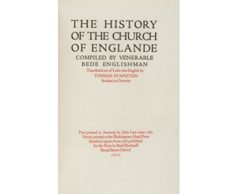
BEDE, THE VENERABLE & STAPLETON, THOMAS - THE HISTORY OF THE CHURCH OF ENGLANDE compiled by Venerable Bede Englishman Translated out of Latin into English by Thomas Stapleton. Shakespeare Head Press/Basil Blackwell, 1930. Limited edition of 475 copies of which 450 were for sale, 4to, wood engravings by John Farleigh after the original edition of 1565, map by W F Colley, printed on Batchelor handmade paper, the majority of gatherings with top edge unopened, bound in quarter-beige calf over marbled boards, the calf spine by G W Russell of Hitchin. A superb publication from the Bernard Newdigate / Basil Blackwell era of the Shakespeare Head Press; FACSIMILE OF THE ORIGINAL MANUSCRIPT OF THE BOOK OF COMMON PRAYER signed by Convocation December 20th 1661, and attached to the Act of Uniformity 1662. London, Eyre & Spottiswoode, 1891. Folio, the original manuscript reproduced in litho facsimile, printed in red and black throughout, top edge uncut, publisher's embossed cloth with wear to head and tail of spine. This copy comes with the rare loose 4-page 'Advance Circular' prospectus, describing the book, and stating "The issue will be limited to 750 copies", as well as a manuscript letter dated Nov 1 1898 with the Eyre and Spottiswoode printed and engraved letterhead, also concerning the book; Plus another folio book in German, circa 1902, with 15 superb full-page facsimile woodcuts after Albrecht Durer. Provenance: St John's College, Nottingham (3)++BEDE - internally and externally very good FACSIMILE MANUSCRIPT COMMON PRAYER - internally very good, spine with wear to top and bottom, upper joint with a 4-inch crack at top of spine, cloth rubbed, worn at edge DURER FACSIMILE WOODCUTS - spine missing, upper board near detached


' Common Book Of Prayer & Administration Of The Sacraments: And Other Rites & Ceremonies Of The Church Of England 1638 ' - Rare 17th century English bible / book of common prayer. Printed by Thomas Buck & Roger Daniel 'Printers to the Universitie Of Cambridge, 1638 '. Splendid large volume, with tooled leather covers and sectional spine. Red lined pages, with various woodcut plates within (appears to contain all plates), and a map of the Holy Land, profusely illustrated. Large; 41cm x 27cm boards. An incredibly rare antique bible.
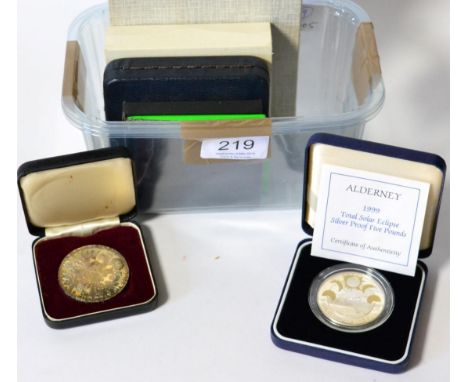
4 x Foreign Silver Proofs comprising: Bahamas 10 dollars 1974 'First Anniversary of Independence' 50.13g sterling silver, struck by Franklin Mint, with cert, in CofI; Bahamas 10 dollars 1978 'Fifth Anniversary of Independence' obv. bust of Prince Charles, 45.3g, .500 silver, with cert, in CofI; Jamaica 25 dollars 1979 '10th Anniversary - Investiture of Prince Charles,' obv half-length portrait of Prince Charles in Investiture robes, 63mm, 137.5g, sterling silver, in CofI, Cayman Islands 50 dollars 1975 'Sovereign Queens of England' 65g, sterling silver, mounted in a hard-backed booklet, together with Alderney sterling silver proof £5 1999 rev. map of Alderney with phases of solar eclipse, with cert, in CofI & a Maria Theresa restrike thaler 1780X, cased, toned UNC


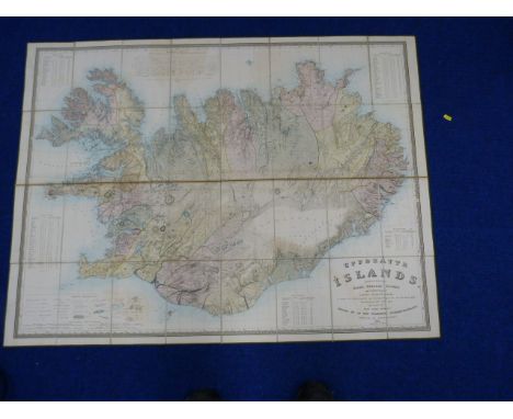
OLSENS O. N. Uppdrattr Islands. Hand col. eng. fldg. linen map of Iceland. 35" x 46". Reykjavik, F. C. Holm, 1844. Condition Report. Slight browning and offsetting, especially along the centre horizontal fold. Some light areas/spots of foxing. No visible holes, tears or repairs or lifting of paper. As images.


ZAPPA 1967 'FREAK OUT' MAP. A stunning piece here; this an original and authentic 1967 'Freak Out' map designed by Frank Zappa and available by mail order (for $1) for people that bought early copies of Zappa & The Mothers Of Invention's 'Freak Out'. Extremely scarce with not many people taking up the offer! The map offers a very unique tour of LA in 1966 and measures 28 1/2" x 23". In excellent condition with machine folds as standard.


Christopher Greenwood (1786 - 1855) and John Greenwood (fl. 1821 - 1840), Map of the County of Derby, from an Actual Survey Made in the Years 1824 & 1825 [...], Published by Greenwood & Co., London, Corrected to the Present Period and Published, February 24, 1830, Engraved by J. & C. Walker, vignette of Chatsworth, The Seat of His Grace the Duke of Devonshire, to margin, steel engraving with hand-colouring, 56cm x 67cm

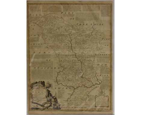
Christopher Greenwood (1786 - 1855) and John Greenwood (fl. 1821 - 1840), Map of the County of Nottingham, from an Actual Survey Made in the Years 1824 & 1825 [...], Published by Greenwood & Co., London, Corrected to the Present Period and Published, January 26, 1831, Engraved by J. & C. Walker, vignette of The Collegiate Church of St. Mary, Southwell, to margin, steel engraving with hand-colouring, 57.5cm x 68cm

Christopher Greenwood (1786 - 1855) and John Greenwood (fl. 1821 - 1840), Map of the County of Rutland, from an Actual Survey Made in the Year 1825 [...], Published by Greenwood & Co., London, Corrected to the Present Period and Published, January 26, 1831, Engraved by Josiah Neele, vignette of Burley House, The Seat of the Earl of Winchilsea, to margin, steel engraving with hand-colouring, 66cm x 76cm

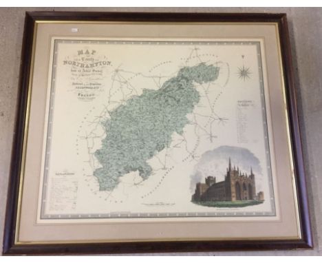
Emanuel Bowen (c. 1694 - 1767), by and after, An Accurate Map of the County of Derby, Divided into its Hundreds and Drawn from the best Authorities, [...Dedicated] To the Most Noble William Cavendish Duke of Devon (sic, presumably the 3rd Duke of Devonshire), [Published by] Carrington Bowles & Robert Wilkinson, London [c. 1750], copperplate engraving with boundaries delineated in hand-colouring, cartouche-shaped title frame with background vignette of water mill, rocks and masonry quirn stone emblematic of the county's natural resources and industry, 73cm x 55.5cm
-
109182 item(s)/page