We found 109198 price guide item(s) matching your search
There are 109198 lots that match your search criteria. Subscribe now to get instant access to the full price guide service.
Click here to subscribe- List
- Grid
-
109198 item(s)/page


Lot 229A
Speed, John. Map of Oxfordshire with inset town plan of Oxford, decorated with the arms of the university colleges, hand-coloured copper engraving on creamy laid, chain-lined paper, London: Bassett & Chiswell [1676]. Measures 40cm by 54.5cm, framed & glazed in Hogarth frame. Appears well-preserved with usual toning, unexamined out of frame
![[Taylor, A. E.] Collection of seven Pratts High Test colour plans & maps, c. 1930, comprising: Pratts High Test Plan of W](https://cdn.globalauctionplatform.com/9514fb91-98c3-4281-942c-afb700d210ec/4a2a2454-f63d-4c49-b000-afb701134adc/468x382.jpg)
Lot 227
[Taylor, A. E.] Collection of seven Pratts High Test colour plans & maps, c. 1930, comprising: Pratts High Test Plan of Watling Street and Principal Roads from Dover to Holyhead; Pratts High Test Plan of Scotland; Pratts High Test Plan of the New Forest; Pratts High Test Plan of the Bath Road; Pratts High Test Plan of the West Country; Pratts High Test Plan of the Roads to the South Coast; Pratts High Test Map of the Great North Road. Various sizes, all loose/rolled. Condition generally good but would benefit from being displayed in archival wallets or frames, some light creasing and tears to margins but in most cases not affecting printed area, some general toning and marks but mostly confined to verso (7)
![Reynolds's Geological Atlas of Great Britain, London: James Reynolds, [c. 1890]. Octavo, contemporary embossed cloth, pp. [vi](https://cdn.globalauctionplatform.com/9514fb91-98c3-4281-942c-afb700d210ec/bea98f9a-0a92-460d-be7c-afb7011199f0/468x382.jpg)
Lot 79
Reynolds's Geological Atlas of Great Britain, London: James Reynolds, [c. 1890]. Octavo, contemporary embossed cloth, pp. [vi], 32, colour frontispiece, and 32 hand-coloured, double-page, lithographic maps. All maps well-preserved & bright with the exception of the final map, which is defective and only represented in part, the text pages have some pale spotting, contents loose from binding with wear & loss to endpapers. Together with a Map of the District of the Handsworth Local Board, by E. Kenworthy, 1892, Birmingham: Billing & Son, sectional, linen-backed, hand-coloured lithograph, well-preserved & bright, in crushed morocco boards lettered in gilt with marbled endpapers, and a folded map of Birmingham & Neighbourhood with advertisements verso (3)

Lot 229
Map of the Environs of Bayonne, London: John Stockdale, 2 December 1813. Hand-coloured, copper-engraving on creamy wove paper, sectional, linen-backed, in original marbled slipcase bearing mapseller's label for W. Faden, Geographer to His Majesty and HRH Prince of Wales. 59.5cm by 93.5cm. Well-preserved. Peninsular War & Napoleonic Wars Interest
Lot 112
Sidney, Samuel. Gauge Evidence: The History and Prospects of the Railway System, Illustrated by the Evidence Given Before the Gauge Commission, London: Edmonds & Vacher, 1846. Large Octavo, 26.5cm, contemporary gilt pictorial cloth, pp. xxxix, [i], 2-400, complete with the folding map, Map of the Districts Occupied by Broad and Narrow Gauge Railways Respectively. Contents generally good & bright, some very pale spotting in a few places, heaviest at title & contents, folding map well-preserved, two owner inscriptions on front endpapers, one short tear to rear free endpaper, cloth worn around headcaps with some splitting to joints and shelf-lean. Gauge Wars Interest


Lot 461
A SMALL QUANTITY OF MAPS AND PRINTS ETC, to comprising a 'Plan of the canal from the Trent to the Mersey' published 1795, approximate size 28cm x 20cm, reproduction Robert Mordon maps 'Cumberland' and Chester', map of Lancashire by Thomas Moule circa 1850, maps of Westmoreland and Cumberland for Lewis' topographical dictionary and Northumberland published by Archibald Fullarton and Co, three assorted prints and three butterfly/moth specimens in display cases

Lot 442
ROBERT MORDEN MAP 'THE KINGDOM OF IRELAND', first published in Camdens Britannia in the 17th century this hand coloured map is probably from an 18th century edition, approximate size 43cm x 35cm including visible margins, Condition Report: some discolouration to the paper along the page fold

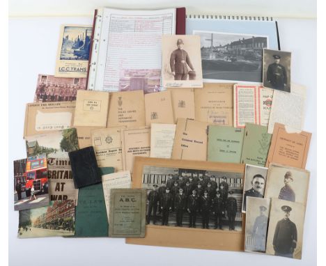
Lot 72
A Collection of Police Ephemera, including seven original photographs, two showing Hampshire Victorian policeman & Metropolitan policeman, a folder ‘History of the traffic department of the ‘Metropolitan Police’ 1919 to 1969, two very nice original pictures of MGB & Daimler Dart, MP The police driver and automatic transmission manual, May 1956 time of card, Nov 1954 Accident report book, Met police specimen reports and hints on taking statements, The criminal record office booklet 10th Feb 1967, notes for the guidance of group C drivers booklet, February 1937 memorandum od the lighting of vehicles booklet, pocket diary for 1869 unused, LCC trams timetable Nov 1932, No 4 1933 Map of General bus routes, ect . (A.lot)


Lot 21
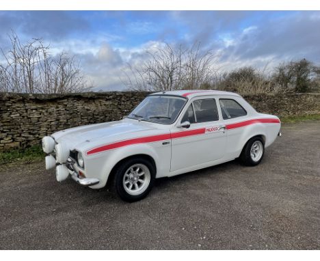
1971 Ford Escort MkI MexicoReg. no. BFL 744KChassis no. BFATLY38069Engine no. L7Transmission: ManualMileage: 1,433 (Since Restoration) The Ford Escort Mk. I Mexico is forever etched in the sands of automotive time as a truly iconic motor vehicle built to celebrate Ford’s relentless onslaught in rallying and their success in the 16,000 miles London – Mexico rally with Hannu Mikkola taking overall victory. No less than five Mk. 1’s finished in the top ten.Built by Ford’s special branch, AVO, on the type 49 shell, the Mexico could leave the factory with a number of motorsport related options including red Mexico decals and steel bubble arches. Under the bonnet was a single cam 1600 crossflow and four speed gearbox. It’s one of those cars that for many is seen as the start of Ford’s undeniable motorsport success in the modern era.This Mexico, according to its VIN plate was built in the Aveley plant and painted in the diamond white it sits in today. It has been adapted to historic / road rally specification with additions such as safety devices, bolt in roll cage, alloy fuel tank and motorsport fuelling setup, as well as rally trip meter and map light. The car received a nut and bolt restoration with 750 hours of work accumulated and the brief was to build a homage to the Hannu Mikkola car from the 1970 world cup rally; many new old stock parts were used.The car has been part of a collection for a number of years and had received a bare metal restoration which was completed in 2013. Since then it has been well looked after and dry stored with just 1,433 miles added. The interior has recently benefitted from a restoration including front and rear seats being retrimmed in January 2022 by Motortrim. The Grp4 strengthened shell is stunning with body and paint in almost perfect condition, those four legendary spot lights taking pride of place at the front, whilst revolution wheels wrapped in Kumho tyres finish off a perfect retro look. The underside has also remained in good order with just minor signs of use. Tell-tale signs of the Type40 shell used for the Mexico builds are still present such as the rear stone deflector on the underside of the boot and reinforced front strut tops. The sale includes a V5C as well as a folder of history that documents the restoration of the car in picture form.Estimate: £30,000 – 35,000To be auctioned along with a fantastic selection of other vehicles on March 5th at our Showell Farm site, SN15 2NU. Viewing is welcome prior to sale and all cars are sold as seen, condition reports can be requested on each lot by contacting us direct. Lots are not available to buy prior to auction. Fully illustrated catalogue is available on the Richard Edmonds Auction website. Bids can be made online, by telephone or live on site. All lots are subject to commission.Vehicles that are un-registered or on foreign plates may require Import Duty and Vat to be paid upon purchase via HMRC prior to registering with the DVLA for a UK plate, if you are not sure please ask. For classic cars over 30 years this equates to 5% Duty on the final value.


Lot 935
Local interest: Various maps to include a Plan of the Welton Estate comprising Welton, Wauldby, Braffords, South Wold and Elloughton 1847, Welton 1890 O.S, a plan/map of Welton village showing proposed railway line, Elloughton O.S. map 1968, 2 x maps showing land required by the Hull & Selby Railway Comp etc.


Lot 73
TALISKER 10 YEAR OLD MAP LABELSingle malt.Even by today’s standards Talisker distillery is a bit out of the way, nestled on the shore of Loch Harport on the west coast of the isle of Skye. This might explain why, in its early days, the distillery frequently changed hands, with owners struggling to turn a profit. It wasn’t until owner Roderick Kemp oversaw construction of a pier in the late 19th century, allowing much easier access for the boats that transported the casks to the mainland, that the distillery’s fortunes began to improve.Despite a minor stumbling block in 1960 when the distillery burned down and had to be completely rebuilt, it has grown to become one of the most recognisable single malt brands in the world.45.8% ABV / 70clFill level at top of shoulder.


Lot 1178
A Luminox Ice-Sar Arctic 1200 series stainless steel cased gentleman's bracelet wristwatch, the signed black Arctic map dial with centre seconds and date aperture, detailed '200m/660ft', the case with bidirectional rotating bezel, the signed case back numbered '1200.0000', the tapered link bracelet with foldover clasp, case width 5cm, cased, with two spare links, instruction booklets and warranty card.Buyer’s Premium 29.4% (including VAT @ 20%) of the hammer price. Lots purchased online via the-saleroom.com will attract an additional premium of 6% (including VAT @ 20%) of the hammer price.

![[MAP]. HEREFORDSHIRE Morden, Robert (c.1650-1703), 'Hereford Shire', engraved county map, uncoloured, sold by Abel Swale Awn](https://cdn.globalauctionplatform.com/fb2b2038-3594-4ad9-b19b-af3c00b8fc17/1d979582-5ef6-4777-9a93-afb0011767ea/468x382.jpg)
Lot 303
[MAP]. HEREFORDSHIRE Morden, Robert (c.1650-1703), 'Hereford Shire', engraved county map, uncoloured, sold by Abel Swale Awnsham & John Churchil, 36cm x 42.5cm, framed and glazed. Condition Report : Generally good condition; worm holes to lower corners and at base of central fold-line. Condition reports are offered as a guide only and we highly recommend inspecting (where possible) any lot to satisfy yourself as to its condition.


Lot 441
STEVENSON, Robert Louis: 'Kidnapped', 1st ed. 1st state. With gift inscr. to G.E.Chadwick Healey (later bart.) dated 1886 from aunt and uncle. Red/brown boards. Fold-out map to front. Black endpapers. 1st ed. 'errors' present on relevant pages (revised for later states); soundly bound but slightly marked pages. A fair true 1st edition, it appears. Please contact if clarifcation needed.
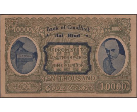
Lot 819
Bank of Goodluck, Jai Hind, a propaganda/political note denominated 1000 good wishes, c.1942, serial number AH/&C 10000, green and blue, Mother India (Bharat Mata) holding a flag and map of undivided India at left, Colonel Gubaksh SIngh Dhillon at right, hole at centre, tape repair, no hard folds, multiple light folds, extremely fine and scarce Pick not listed £100-£150
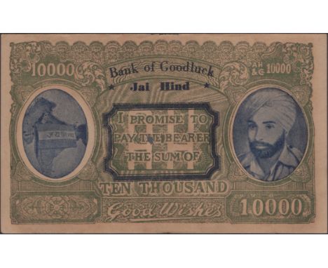
Lot 820
Bank of Goodluck, Jai Hind, a propaganda/political note denominated 1000 good wishes, c.1942, serial number AH/&C 10000, green and blue, Mother India (Bharat Mata) holding a flag and map of undivided India at left, Jawaharal Nehru at right, no hard folds, multiple light folds, extremely fine and scarce Pick not listed £100-£150

Lot 822
Pakistan Bank Limited Jinnah Abad, a propaganda/political note denomination 1000, c.1942, Muhammad Ali Jinnah at right, pro Pakistan and Islam slogans, Indian map with proposed East and West areas highlighted, proposed Pakistan flags on reverse, printed in Lahore, very fine, interesting and rare Pick not listed £200-£300
Lot 13
Heber (Reginald). Narrative of a Journey through the Upper Provinces of India, from Calcutta to Bombay, 1824-1825, (with notes upon Ceylon), an account of a journey to Madras and the Southern Provinces, 1826, and letters written in India, 2 volumes, 1st edition, London: John Murray, 1828, engraved frontispieces to each, 8 engraved plates (of 9, lacking 'Pagoda' to p.47 of 1st volume), engraved map with outline colouring, wood-engraved illustrations to text, spotting, a few gatherings to volume 2 damp-stained, original terracotta boards, untrimmed, paper spine labels, joints cracked with volume 1 boards loosening, worn & faded, 4to, together with:National Liberal Federation of India. Report of the Proceedings of the Eleventh Session of the National Liberal Federation of India, held at Allahabad, on December 30 and 31, 1928, Allahabad: Krishna Ram Mehta, circa 1928, original wrappers bound-in, lightly spotted, text block separating from spine, contemporary brown quarter cloth, small folio, withPapers connected with the Industrial Conference held at Naini Tal, 1907, bookplate of Pandit Sundar to front pastedown, lightly toned & spotted, contemporary green morocco gilt, worn, 4to, with 12 other travel volumes, mostly related to IndiaQTY: (16)

Lot 148
* Arabia. Munster (Sebastian), Tabula Asiae VI, Basel circa 1545, hand-coloured woodblock map on a trapezoidal projection, 275 x 340 mm, mounted, framed and glazed, together with D'Anville (Jean Baptiste Bourguignon). A New Map of Arabia divided into its several Regions and Districts..., Laurie & Whittle, 12th May 1794, engraved map with contemporary outline colouring, 470 x 600 mm, mounted, framed and glazedQTY: (2)
Lot 15
Hutchinson (Lieutenant-Colonel Graham Seton). The Thirty-Third Division in France and Flanders 1915-1919, London: Waterlow & Sons, 1921, folding map, illustrations, some toning to endpapers, inscribed by E.H. Gowing, 20th Royal Fusiliers, original cloth-backed boards, a little rubbed, 4to, together with Graham (Colonel Henry). History of the Sixteenth, the Queen's Light Dragoons (Lancers) 1912 to 1925, Devizes: privately printed by George Simpson, 1926, half-tone illustrations, 4 folding maps contained in rear pocket, top edge gilt, original red cloth, slight fading to spine, 4to, plus Wyrall (Everard). The History of the Duke of Cornwall's Light Infantry 1914-1919, London: Methuen, 1932, folding maps and illustrations, endpapers slightly toned, top edge green original cloth, 4to, with other regimental histories including The Green Howards in the Great War, by Colonel H.C. Wylly, 1926, The 4th (Queen's Own) Hussars in the Great War, by Captain H.K.D. Evans, 1920, History of the 1/1st Hants Royal Horse Artillery during the Great War, 1914-1919, edited by Captain P.C.D. Mundy, 1922, and Britain's Sea Soldiers. A Record of the Royal Marines during the Great War 1914-1919, compiled by General Sir H.E. Blumberg, 2 volumes (text/maps) [1927] QTY: (20)
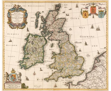
Lot 151
British Isles. Visscher (Nicolaes), Magnae Britanniae Tabula Angliam, Scotiam et Hiberniam..., circa 1670, engraved map with contemporary outline colouring and some later enhancement, large floriate cartouche, central fold strengthened and repaired on verso, small margins, 450 x 530 mm.QTY: (1)NOTE:R. W. Shirley. Printed Maps of the British Isles 1650 - 1750. Visscher 1, state 4.
![Cary (John). A New Map of Sussex divided into hundreds, exhibiting its roads, rivers, parks &c, 1801 [and] A New map of K](https://cdn.globalauctionplatform.com/14d4f542-a179-4b38-b79b-afa100a4c073/18546ad4-398b-42ad-9baa-afab010b596a/468x382.jpg)
Lot 152
Cary (John). A New Map of Sussex divided into hundreds, exhibiting its roads, rivers, parks &c, 1801 [and] A New map of Kent divided into lathes and subdivided into hundreds exhibiting its roads, rivers, parks, &c, 1806, two engraved maps with contemporary hand colouring, ovoid cartouche and table of reference, each approximately 500 x 570 mm, together with Smith (Charles), A New Map of the county of Surrey divided into hundreds, 1808, engraved map with contemporary hand colouring, tables of reference and explanation, 470 x 520 mm, with Cowley (John), An improved Map of the county of Surrey containing the borough and market towns..., [1744], engraved map with outline colouring, trimmed to neatline and laid on later paper, 130 x 180 mm, mounted, plus Walker (J & C), Kent [and] Devonshire, circa 1835 and circa 1848 respectively, two engraved maps with contemporary outline colouring, each approximately 330 x 400 mm, and Cary (John), Surrey [and] Dorsetshire, 1793 & 1795 respectively, two engraved maps with contemporary outline colouring and some later additional hand colouring, each 220 x 270 mm, mounted, with Archer (J.), Surrey, circa 1848, engraved map with contemporary outline colouring, 190 x 240 mm, mounted and Greenwood (C. & J.). Map of Oxford from an Actual Survey..., 1834, engraved map with contemporary hand-colouring, inset uncoloured vignette of Oxford Cathedral, calligraphic title, explanation and compass rose, slight offsetting, 585 x 710 mmQTY: (10)
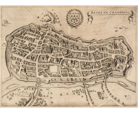
Lot 153
* Champagne. Jansson (Jan), Reims en Champagne, circa 1655, uncoloured engraved town plan, slight staining, 375 x 510 mm, mounted, framed and glazed, together with Jaillot (Hubert). Gouvernement General de Champagne..., Paris, 1692, uncoloured engraved map after Nicolas Sanson, on two conjoined sheets, large floriate cartouche and mileage scale, 770 c 550 mm, mounted, framed and glazedQTY: (2)NOTE:The Jansson town plan was originally published in "Theatrum exhibens celebriores Galliae et Helvetiae urbes…Illustriorum Regni Galliae civitatum tabulae ut et Helvetiae confoederatae civitates celebriores".
-
109198 item(s)/page