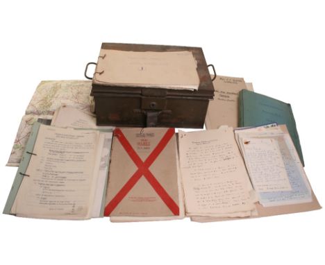

IMPORTANT INTELLIGENCE OFFICER’S PAPERS, 11th ARMOURED DIVISION 1941-1945. CAPT. STOCKDALE. This large collection includes, Stockdale’s Intelligence File containing, exercises conducted in 1941/42 one looking at the responses to a German invasion. Also assessments of German Armoured and Airborne forces etc. In addition a “Top Secret” assessment of Market Garden presented at the Staff College, November 1944 with supporting map, together with similar report on the Ardennes battle with some interesting maps. Also substantial “Most Secret” documents on the Tunisian invasion, including plans, hand coloured maps, German tactics etc. Together with very rare original handwritten” war diary log” for First Army Command (Tunisia) c. 100 pp., Also Order of Battle for the Assault. Similar papers dealing with occupation of Norway, includes Orders of Battle added to map and German “reservations and dumps”. In addition maps, numerous letters and his wartime steel document box. Overall a very desirable collection providing both first hand and unique material.
We found 109198 price guide item(s) matching your search
There are 109198 lots that match your search criteria. Subscribe now to get instant access to the full price guide service.
Click here to subscribe- List
- Grid
-
109198 item(s)/page

IMPORTANT D-DAY OFFICIAL EPHEMERA. Original documents relating to landing of Airborne Forces, Secret Targets for June 6th 1944,etc.Air Operations 2nd TAF, description of air combats, beach cover Utah, “Spitfire seen destroyed, etc., flak damage,” combat report 315 Squadron, July. Airfield descriptions and photographs (St.Croix sur Mer etc.). Original target maps Lille, Merville Aerodrome, Le Havre, St Omer, Evreux, Cherbourg etc. Carentan,etc. Also Cap D’Antier Giant Wurzburg, detailed 1:3600 map and original aerial photographs, also 4 intelligence summaries etc. etc. Considerable quantity, viewing recommended.

SET OF MAPS OF RAILWAYS INTEREST BY EDWARD STANFORD, LONDON, the maps were a series of 24 produced in 1876, titled “Large Scale Map England & Wales Showing The Railways In Operation, The Stations and also The Sanctioned Lines, High Roads, Towns, Villages & c”. 18 of 24 piece set. Generally in good condition. (18 items)

SELECTION OF EARLY MAPS OF RAILWAYS INTEREST consisting of linen backed No55 Bradshaw’s Map of Great Britain Showing the Railways Completed and In Progress 1855 published by G & J Cary, London; Black’s Road & Railway Travelling Map of England, similar example for Scotland both with engravings by S HALL, Bradshaw’s New Railway Map of Great Britain 1848, Bartholomew’s Railway Map of the British Isles, plus one other map. Various conditions. (6 items)
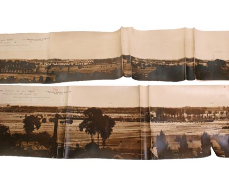
ORIGINAL WWI PANORAMA NO P157 MONT DES CATS, KEMMEL HILL, 24-JULY 1918 FIELD OF VIEW 88 DEGREES. Interesting original panorama from the British trenches looking over the German positions, some of which were captured during the German April Offensive. In the distance are the dominating Kemmel Hill and Mont des Cats, with destroyed villages in the foreground. The first section is a photographic trench map showing the position from which the panorama was taken. c.6 feet in all. A few minor edge wear, else very nice condition. Rare item,

MAP OF CENTRAL TOKYO 1946 Interesting and large coloured military map of Central Tokyo, (Advance Edition)1:20,000 produced November 1946, by US Military Occupation Forces ( 64th Engr. Topo, Bn.) showing Numbered Military routes, Bus routes, Military Installations etc Instructions in use on reverse. C.70cms x 90cms.

ORIGINAL TRENCH MAP, SCHAAP-BAILIE (INCLUDES POELCAPELLE) 1:10,000 TRENCHES CORRECTED 4.10.17. Particularly good special trench map covering an area which was part of the Third Ypres battle, shows trenches, machine gun positions, “Pill boxes” etc and most significantly unit objectives hand added in red and blue ink with additional positions named updated.. C. 40cms x 40cms. Linen and folding. Nice contemporary map.
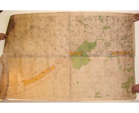
FIRST WORLD WAR ORIGINAL MAP SHOWING MOVEMENTS, CAPTURES & HEADQUARTERS OF BRITISH 17TH DIVISION “100 DAYS” CAMPAIGN AUGUST, SEPTEMBER, OCTOBER, NOVEMBER 1918, WESTERN FRONT. Very large folding map c.11 feet x 3.5 feet! (2 joined) showing the stages of the 17th Division’s advances against the Germans, with captures etc, clearly indicated at each stage. No doubt the map was used by the Division HQ Staff and is a very unusual item providing a very effective diagramatic representation. Linen map, rolled. Bulky item.


Geology - Fox-Strangeways (C), Memoirs of the Geological Survey of England & Wales, The Geology of the Leicestershire and South Derbyshire Coalfield, With Paleontological Notes and List of Fossils by A.R. Horwood, HM Stationery Office, London 1907, vi + 373pp, six pull-out demonstrative plates of the strata, b/w illustrations en text, armorial bookplate of John Turner; Breedon Everard (J.), Charnwood Forest: A Sketch, Written for the Leicester Meeting of the British Association for the Advancement of Science in 1907, Edward Shardlow, Leicester 1907, 8vo, viii + 100pp, 24 b/w illustrations thruoghout, pull-out map to title-page, period buckram (2)

![John Speede (1552-1629) (sic), after, a two-page map, Darbieshire (sic) [Derbyshire], margins with arms of the noble county f](https://cdn.globalauctionplatform.com/17a5bb55-f821-470f-91f4-a5c200d86e75/b688f96f-0065-4859-cf8e-67a930d3dee1/468x382.jpg)


Local Interest - Robertson (William Henry), A Guide to the Use of the Buxton Mineral Waters, twenty-fifth revised and enlarged edition, C.F. Wardley, Buxton 1894, pamphlet 67pp + contents; Cokayne (Andreas Edward), Bakewell and Its Vicinity: Excursions, Drives, & Walks[...]Some Notes on Stone Circles and other Rude Stone Monuments, Simpkin, Marshall, Hamilton, Kent, & Co [c. 1890], pamphlet, 106pp; Wardley (C.F.), The Rambler's Guide to Buxton and Neighbourhood, With Map and Street Plan, fourth illustrated edition, pamphlet, 61pp + adverts; Abel Heywood's Guide Books, Buxton 1905 and Dovedale & Ashbourne Illustrated 1900 (5)

Glover (Stephen), The History and Gazetteer of the County of Derby: Drawn up from Actual Observation, and from the Best Authorities: Containing the Parochial and Family History, Biography, and Statistical Information, edited by Thomas Noble, Esq., Henry Mozley and Son, Derby 1829-33, volume I and volume II - part II [complete as published], pull-out county map to title page, pull-out pedigrees, original boards, 8vo

Geology - Mammatt (Edward), A Collection of Geological Facts and Practical Observations, Intended to Elucidate the Formation of the Ashby Coal-Field, In The Parish of Ashby-de-la-Zouch and the Neighbouring District; Being The Result of Forty Years' Experience and Research, Printed and Sold by W. Hextall, Ashby-de-la-Zouch, Published by Geo. Lawford, London 1834, 4to, xii + 101pp, folding map to front, 102 coloured plates of fossils by G. Lawford, 12 leaves of coloured sections, others monochrome, half leather and marbled boards


Richard Blome (1635-1705), by and after, A Mapp of Worchestershire With Its Hundreds (sic), hand-coloured engraved map, 28.2cm x 23.4cm, inscribed to verso [...]Guaranteed 1672; Emanuel Bowen (c. 1694-1767) and John Owen (?-?), by, a double-sided road map, Barnsley, Halifax, Skipton, Richmond, No. 123 and 124, published by Thomas Bowles for Britannia Depicta, later hand-coloured engraving, 18.5cm x 11.6cm (2)


Dorset - Emmanuel Bowen (1694-1767), after, John Ogilby (1600-1676), a four-bar road map from Cranborn to Weymouth, page 136, Britannia Depicta, printed for Thomas Bowles, Chapter Houfe (sic), in St. Paul's Church- Yard, London 1736, fourth edition, hand coloured engraving, printed to verso with page 135 in monochrome, 18cm x 12cm; V.M. Picot, after, William Tompkins (1730-1792), Encombe in Dorsetshire a Seat of John Pitt Esqr. (sic), three-fold hand coloured panoramic copper engraving, 24.5cm x 41.5cm (2)


Cervantes Saavedra (Miguel de), The Life and Exploits of the Ingenious Gentleman Don Quixote de la Mancha, translated by Charles Jarvis, William Miller, London 1810, 8vo, four-volume set, volume I with three-fold map of Spain after Don Joseph de Hermosilla, full period calf, the spines tooled in gilt with title and Maltese crosses within compartments, raised banding, marbled pastedown Provenance: Sotheby's, Lot 280, Noseley Hall [nr. Billesden, Leicestershire], September 28th 1998 (with buyer's invoice)


British Travel & Architecture - Evans (John), An Excursion to Brighton, With An Account of The Royal Pavilion: A Visit To Turnbridge Wells; And A Trip to Southend, second edition, T. Whittingham, Chiswick 1823, 304pp, engraved frontispiece, original cloth; Anonymous, Glasgow Delineated; In Its Institutions, Manufactures, and Commerce: With A Map of the City, second edition, University Press, Glasgow 1827, 252pp, engraved frontispiece, others throughout, original cloth; Holbeche Bloxam (Matthew), The Principles of Gothic Ecclesiastical Architecture, sixth edition, London 1844, original cloth (3)


Robert Modern (1650-1703), by and after, Leicestershire, a two-page map, hand-coloured engraving, c. 1695, 39cm x 44cm; an 18th century map of Leicestershire, with reference to borough and market towns, hand-coloured copperplate engraving, 19.5cm x 15cm; Walker, after, John Throsby (1740-1803), a four-part view of Belvoir Castle, north west view of Burrow Hill, Bradgate Ruins and Belvoir and Knipton, Pl. XXIV from Throsby's Select Views in Leicestershire, published by the author at Leicester in 1790, hand-coloured copperplate engraving, 16.5cm x 21cm (3)

Local Interest - The Ballads & Songs of Derbyshire, edited by Llewellyn Jewitt, Bemrose and Sons, London 1867; Cheetham (F.H.), Haddon Hall: An Illustrated Account of the Fabric and its History, Sherratt and Hughes, London 1904; Anonymous [Baroness de Calabrella], Evenings at Haddon Hall: A Series of Romantic Tales of the Olden Time, With Illustrations by George Cattermole, Henry G. Bohn, London [1850]; Bemrose's Guide to Derbyshire 1872; other guides to Derbyshire, including Cox, Baddeley and Black's; albums of reproduced photographic views of Buxton, Matlock; 25-inch map of Chapel-en-le-Frith; Peak District topography (14)
![Robert Morden (c. 1650-1703), after, a two-page map, Darbyshire (Derbyshire), [1722], hand-coloured engraving, 36cm x 42cm](https://cdn.globalauctionplatform.com/17a5bb55-f821-470f-91f4-a5c200d86e75/b0d0caa7-a662-4e45-aca6-651a17230228/468x382.jpg)
![Johanes Blaeu, after, a two-page map, The East Riding of Yorkeshire [Yorkshire] (sic), eighteenth-century hand-coloured Frenc](https://cdn.globalauctionplatform.com/17a5bb55-f821-470f-91f4-a5c200d86e75/4884cb7d-3d44-4dc7-8997-2812ce7cd65d/468x382.jpg)


![Petrus Bertius (1565-1629), after, Eboracum[,]Lincolnia[,]Derbia[,]Staffordia etc (sic), from Tabularum geographicarum contra](https://cdn.globalauctionplatform.com/17a5bb55-f821-470f-91f4-a5c200d86e75/52c71398-905a-40c5-a734-a897ffa8676b/468x382.jpg)
Petrus Bertius (1565-1629), after, Eboracum[,]Lincolnia[,]Derbia[,]Staffordia etc (sic), from Tabularum geographicarum contractarum, hand-coloured map, copperplate engraving, [Amsterdam c. 1639], 10cm x 14cm; John Seller (1630-1697), by, The County of Darby (sic), hand-coloured copperplate engraved map, [c. 1671], 13cm x 15.5cm; an early 17th century map of Derbyshire, hand-coloured engraving, 9.5cm x 13.5cm (3)

Cary's New Map of England and Wales, With Part of Scotland, On Which Are Carefully Laid Down All the Direct and Pricipal Crofs Roads, the Courfe of the Rivers and Navigable Canals, Cities, Market and Borough Towns, Parishes, and most considerable Hamlets, Parks, Forests[...]Delineated from Actual Surveys; and materially afsifted from Authentic Documents Liberally supplied by the Right Honourable the Post Masters General (sic), second edition, John Cary, Engraver & Map-seller, No. 181 Strand, [London] 1816, quarto, 81pp of hand-coloured double maps, index 88pp [lacking]


-
109198 item(s)/page