![[WILLOX (J)] GUIDE TO THE EDINBURGH AND GLASGOW RAILWAY INCLUDING GUIDES TO EDINBURGH AND GLASGOW map and two plans, all fold](http://lot-images.atgmedia.com/SR/10086/2899613/661-20149415567_468x382.jpg)

[WILLOX (J)] GUIDE TO THE EDINBURGH AND GLASGOW RAILWAY INCLUDING GUIDES TO EDINBURGH AND GLASGOW map and two plans, all folding, wrappers, Edinburgh 1845 § and seven others comprising Sixpenny Guide to the Skye Railway with Excursions to Lochs Maree and Torridon Gairloch Skye etc [Ottley 6163] [1870], John Warden, The Glasgow and Aire and Glasgow and Greenock Railway Companion [Ottley 5645], Glasgow 1841, Lizars Guide to the Caledonian Railway...., Opened 1847, second edition, Edinburgh 1848, James Bruce, Tullis`s Guide to the Edinburgh & Northern Railway..., recent cloth [Ottley 7001], Cupar 1848, Angus J Beaton, Illustrated Guide to the Black Isle Railway with Historical and Traditional Notes on Cromarty and a Chapter on the Geology of the Black Isle, Dingwall 1894 (defective), W Ferguson, The Great North of Scotland Railway a Guide, Edinburgh 1881 and William Paterson, Paterson`s Guide to Glasgow the Clyde and Land of Burns, recent cloth, yellow wrappers preserved, c1870 (8)
We found 109182 price guide item(s) matching your search
There are 109182 lots that match your search criteria. Subscribe now to get instant access to the full price guide service.
Click here to subscribe- List
- Grid
-
109182 item(s)/page

CHURTON (EDWARD) THE RAILROAD BOOK OF ENGLAND HISTORICAL TOPOGRAPHICAL AND PICTURESQUE folding map (repaired) and engraved illustrations, red cloth, worn and stained, 1851 § Reginald B Fellowes, History of the Canterbury and Whistable Railway, 1930 § Francis Wishaw, The Railways of Great Britain and Ireland Practically Described and Illustrated, 1840 § William Weaver Tomlinson, The North Eastern Railway its Rise and Development, 1914 § Official Hand-book of Stations....1956 § and nine others, similar (14)


J F KENNELL AN ACCURATE DESCRIPTION OF THE LIVERPOOL AND MANCHESTER RAILWAY second and third editions, lithographs, some folding and map, wrappers, one stained, the other with loss, Liverpool 1830 and 32 § Henry Booth, An Account of the Liverpool and Manchester Railway Comprising... a Description of the Railway in an Excursion from Liverpool to Manchester...., plates, folding section and map, old half morocco, 1830 (3)

MIDLAND RAILWAY COMPANY A SMALL COLLECTION OF PAPERS ON ITS DEVELOPMENT OF INCLUDING THE JUBILEE OF THE RAILWAY COMPANY READ AT DERBY AND ELSEWHERE C1872-94, printed Railway Club Papers, one inscribed author`s compliments and an interesting collection of 19th century railway cuttings of Midland Railway and Derby interest § Midland Railway Panoramic Guide, new edition, map, yellow wrappers, 1874 § The Midland Railway Mainline-London to Carlisle, original pen and ink map divided into sections, partly coloured, scarlet buckram gilt, dated 1902-03 and a quantity of Midland Railway gradient sections, recent green cloth (15 approx)

ROSCOE (THOMAS) THE LONDON AND BIRMINGHAM RAILWAY WITH THE HOME AND COUNTRY SCENES ON EACH SIDE OF THE LINE... plates, engraved title and illustrations throughout, folding map in colour, generally lightly soiled, original cloth, stained and repaired [?1839] § Francis Coghlan, The Iron Road Book and Railway Companion from London to Birmingham, Manchester and Liverpool...., maps and folding table, pictorial cloth, 1838 (2)

MORTON & CO, PUBLISHERS AN ILLUSTRATED AND DESCRIPTIVE GUIDE TO THE GREAT RAILWAYS OF ENGLAND AND THEIR CONNECTIONS WITH THE CONTINENT wood engraved illustrations and double page map, red cloth gilt [?c1860] § Charles S Lake, The World`s Locomotives [? c1910] § D K Clark, The Steam Engine, four vols [? c1900] § and approx forty others, railway workings (40 approx)


THOMAS JEFFERYS THE KINGDOM OF BOHEMIA WITH THE DUTCHY OF SILESIA AND THE MARQUISATES OF MORAVIA AND LUSATIA double page engraved map with margins from A Universal Atlas (published 1802), 1794, coloured, 54.5 x 69cm and a large collection of English county and European maps including plans of London wards, by various cartographers, 17th-early 19th c, several laid down, unframed (100 approx) ++Long having been kept in a folio with typical handling marks and creases, some very fine

LAYARD (AUSTEN HENRY) NINEVEH AND ITS REMAINS presentation copy signed on the ffe Ida Rate with the affectn regards and sincerest good wishes from the author A H Layard Augt 1891, two vols, lithographed frontispiece, plates and illustrations in the text, folding illustration, plans and map, crushed maroon morocco gilt by J Leighton, Brewer St, aeg bookplate of William Douro Hoare, 1849 (2) Provenance: Presented by Layard to Ida Mary Lilian Rate (1870-1944) who in 1891 was married in St George`s Hanover Square to William Douro Hoare (1862-1928); thence by descent to the present vendor.

JOAN BLAEU LINCOLNSHIRE double page engraved map with margins, hand coloured, French text verso, 1645, 48.5 x 57cm ++An excellent example - clean with a few thunder flies under the glass, the reverse glazed, in Hogarth frame with on the reverse the label of R S Savage & Sons Northampton supplied to the late vendor c mid 19th century, undisturbed and unexamined out of the frame

CHARLES SMITH A NEW MAP OF THE COUNTY OF WESTMORELAND double page engraving from Smith`s New English Atlas, hand coloured, 1801 [or later], 52 x 62cm, Robert Whitworth, A Plan of the Proposed Navigable Canal from the Leeds & Liverpool Canal near Eccleston.... to Kendal, engraving, coloured, 1772 and Alexander Dalrymple, Both Hemispheres and the Great Pacific Ocean, etching from Historical Collection of the Several Voyages and Discoveries in the South Pacific Ocean, 1769 [1770] (3) ++An attractive group all in apparently very good condition unexamined out of the frames

[Anderson, George William. A New Authentic and Complete Collection of Voyages Round the World... Containing an Authentic, Entertaining, Full and Complete History of Captain Cooks First, Second, Third and Last Voyages..., c. 1784], lacking all text before p.15, 149 engraved plates only (of c. 155, lacking portrait of Cook, World map and others), some tears and losses, soiling and stains, disbound, folio. Sold as a collection of plates not subject to return. -1

Crawfurd (John). Journal of an Embassy from the Governor-General of India to the Court of Ava in the year 1827... with an appendix containing a description of fossil remains by Professor Buckland and Mr Clift, 1st edition, 1829, large folding engraved map (some offsetting), four (of five) aquatint plates (2 hand-coloured, 2 tinted), lacking half-title and frontispiece of the white elephant, one engraved plan (offset to text), five lithographed plates of fossils bound at rear, wood-engraved illustrations in the text, some occasional spotting to text and plates, remains of library labels to front endpapers, contemporary quarter calf, worn, broken on spine and covers detached, 4to. Abbey, Travel 405 -1
![Faden (William, publisher). [General Atlas, c.1816,] inserted b & w litho. portrait of Princess Alexandria of Denmark, l](http://lot-images.atgmedia.com/SR/10729/2911220/20-201497133739_468x382.jpg)
Faden (William, publisher). [General Atlas, c.1816,] inserted b & w litho. portrait of Princess Alexandria of Denmark, lacking title, fifty-nine (58 called for in contents list), engraved folding maps with contemp. outline colouring, some offsetting, hemispheral maps trimmed to neat line, occ. spotting, f.e.p.s, contents list and first map detached, contemp. half morocco, upper board detached, spine partially lacking, worn and frayed, folio. The atlas has maps dating from 1794 - 1816 The collation shows an additional map of France and the map of Switzerland has been replaced with a French edition of the same map. -1
Guthrie (William). A New Geographical, Historical, and Commercial Grammar; and Present State of the Several Kingdoms of the World..., 12th ed., printed for Charles Dilly, 1790, folding double hemisphere map frontispiece, twenty three further plates and maps (mostly folding), some offsetting, light spotting and a little foxing, contemporary marbled calf, rebacked and recornered, thick 8vo -1
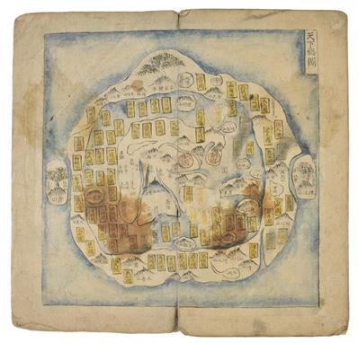
Korean Atlas. Untitled manuscript atlas, mid 19th century, thirteen double page manuscript maps in black ink and wash colour, each map laid down on thicker contemp. paper, some dust soiling and staining, manuscript title to rear siding, contemp. paper wrappers, rubbed and worn, overall size 330 x 170mm. Decorative Korean manuscript atlas following the usual tradition of such atlases: The World, Japan , Ryukyu Islands, China, and the nine provinces of Korea.The world map, the Chonhado (all under heaven), follows a pattern set before 1400 in either China or Korea. Most of the 143 names that appear on this world map come from the oldest Chinese source-books on geography, the so-called Shanhai-jing (c. 200 BC), so the original is probably Chinese. The Chonhado in fact reflects the text of the Shanhai-jing, just as the Renaissance Ptolemaic maps reflect Ptolomaeus text, and actually is the only remaining reflection of these books. The Chonhado shows China in the middle, surounded by ocean; the other countries are in the second circle and again, another ocean surrounds them.The other maps of China, Japan, and Korea also have their origins in 1471 or before. The China map illustrates the Ming division of provinces -13 and capitals -2 and, indicated with the small white circles, the nine islands, marked by Yu as he drained China after the floods. -1

Leguat (Francois). A New Voyage to the East-Indies... Containing their Adventures in two Desart Islands, 2 parts in one, 1st English ed., 1708, engraved frontis., title printed in red and black, 31 engraved maps and plates (of 32, lacking most of large folding map), one or two tears and repairs, some light soiling and waterstains, hinges reinforced, coontemporary calf, a little rubbed, 8vo, together with Anson (George), A Voyage Round the World, in the Years MDCCXL, I, II, III, IV... Compiled... by Richard Walter, 4th ed., 1748, two folding engraved charts (of three, lacking chart of the Track of the Centurion), one repaired to verso, the other close-trimmed at lower margin, previous owner inscription crossed through on title, some light soiling, endpapers renewed, contemporary calf, rebacked, a little rubbed, 8vo -2
Ruttledge (Hugh). Everest: The Unfinished Adventure, 1st ed., 1937, two folding maps, numerous illustrations, presentation inscription, original blue cloth, spine ends a trifle rubbed, 8vo, together with The Ascent of Nanda Devi, by H.W. Tilman, with a foreword by Dr. T.G. Longstaff, 1st ed., CUP, 1937, folding map, half-tone illustrations, light toning, original blue cloth, spine a little rubbed and darkened, 8vo, plus The Epic of Mount Everest, by Sir Francis Younghusband, 1st ed., 1926, b & w illustrations, pubs. list at end, scattered spotting, original cloth, some mottled dampstains, 8vo, with a presentation inscription from Colonel E.L. Strutt, support climber, with four others related including H.W. Tilmans Mount Everest 1938, 1948 and China to Chitral, 1951 -7
Scheffer (John). The History of Lapland: Containing a Geographical Description, and a Natural History of that Country; with an Account of the Inhabitants ..., 1704, additional folding engraved title (browned, some marginal fraying and short closed tears), folding engraved map, three enraved plates (one folding and numerous full page engraved illustrations, hole at foot of B1, contemporary blind panelled sheep, rebacked and corners repaired, 8vo -1

Tavernier (Jean Baptiste). Beschreibung der sechs Reisen welche Johan Baptista Tavernier, Ritter und Freyherr von Aubonne, in Turkey, Persien und Indien, innerhalb viertzig Jahren, durch alle Wege, die man nach diesen Ländern nehmen kan, verrichtet..., 5 parts in one, 1st German edition, Geneva: J. H. Widerhold, 1681, gothic letter text printed in double-column, general title printed in red & black with woodcut vignette, three further titlepages with woodcut vignettes, lacking the additional engraved title, and portrait at front of volume, twenty engraved plates (including a double-page map of Japan and single-page map of the coast of Tunquin), final plate printed to verso of fourth title-page, occasional woodcut illustrations to text, contemporary full vellum, some minor marks and discolouration, folio. The section of gold and silver work in Part Two is bound after the contents, and before the main body of the text. -1
Weld (Isaac, junior). Travels Through the States of North America, and the Provinces of Upper and Lower Canada, During the Years 1795, 1796, and 1797, 2 vols., 2nd ed., 1799, large folding engraved map with outline colour, 15 folding engraved plates, plans and maps, some light spotting and offsetting, library stamps and labels at front, contemporary calf, rebacked, a little rubbed, 8vo. Sabin 102541 -2
Wilson (William Rae). Travels in the Holy Land, Egypt, etc., 2 vols., 3rd ed., 1831, thirteen uncoloured aquatint plates, some spotting, contemporary half calf gilt, joints cracked, upper board of vol. 1 loose and lacking upper panel to spine, rubbed, 8vo, together with Kelman (John), The Holy Land, pub. Adam & Charles Black, 1902, numerous colour plates, including few leaves & plates detached, t.e.g., remainder untrimmed, original cloth gilt, dust soiled, 4to, (limited Deluxe edition 346/500), with Jackson (T.G.), Dalmatia, The Quarnero and Istria with Cettigne in Montenegro and the Island of Grado, 3 vols., Oxford, 1887, folding map, b & w plates and illustrations, few hinges splitting, t.e.g., remainder untrimmed, original cloth gilt, spines faded and marked, frayed at head and foot, 8vo, plus three others -9

Wyld (James, publisher). A New General Atlas of Modern Geography, Consisting of a Complete Collection of Maps of the Four Quarters of the Globe......, c.1845, title page and contents list printed in green and black, fifty-two maps on fifty-eight sheets (fifty double page and folding), all with contemp. outline colouring, and three engraved b & w tables, plus an additional uncalled for litho. map of the Ottoman Dominions (dated 1877), occ. slight offsetting, title contents and first two maps detached, occ. marginal fraying, contemp. half sheep, morocco gilt label to upper board, upper board detached, spine lacking, worn and frayed, folio -1
Aubrey (John). Aubreys Collections for Wilts, (Edited by Sir T. Phillipps), parts 1 & 2, 1821 & 1838, few woodcut illustrations, edges untrimmed, contemporary half morocco gilt, 4to, together with Bowles (W.L., and Nichols, John Gough), Annals and Antiquities of Lacock Abbey, in the County of Wilts... including Notices of the Monasteries of Bradenstoke, Hinton, and Farley, 1835, twelve engraved plates and plans, engraved illustrations to text, pedigrees (some folding), t.e.g., remainder untrimmed, later half morocco, rubbed, 8vo, with Scrope (G. Poulett), History of the Manor and Ancient Barony of Castle Combe, in the County of Wilts, 1852, chromo frontispiece, one chromo & two lithograph plates, few wood engraved illustrations to text, bound without map (as usual), presentation copy inscribed to title page Charles Stanton Esq. with the best regards of the author, ex-lib. with label to verso of frontispiece & ink stamp to front endpaper, modern buckram, 4to, and Smith (James), Wilton and its Associations, Salisbury, 1851, wood-engraved illustrations to text by W.F. Tiffin, edges untrimmed, recent boards, small 8vo. The title of the second part of the first volume in the lot is entitled, An Essay Towards the Description of the North Division of Wiltshire..., Typis Medio-Montanis [Middle Hill], 1838,. -4
Barclay (Rev. James). A Complete and Universal Dictionary of the English Language...., New Edition, c.1848, portrait frontis. of Queen Victoria, addn. dec. half title, forty-eight uncoloured engraved county maps and town plans by Thomas Moule, one map (Suffolk) with short closed tear, plus twenty engraved overseas maps by W.Hughes, most with contemp. outline colouring and twelve engraved plates, occ. browning, contemp. calf, boards detached, spine frayed, worn and scuffed, 4to, with another edition of 1815 containing twenty overseas engraved maps (including two folding) all with contemp. hand colouring, contemp. manuscript family tree on rear end paper and pastedown, Ex Libris blind stamp to f.e.p., contemp. calf, rebacked but retaining original gilt dec. spine, 4to -2

Cole (George & Roper, John). The British Atlas; Comprising a Complete Set of County Maps of England and Wales; with a General Map of Navigable Rivers and Canals and Plans of Cities and Principal Towns, 1810, title page and contents list, fifty-eight maps with contemp. outline colouring and twenty-one uncoloured engraved town plans (complete as lists), each with tissue guard, slight marginal dust and finger soiling, near contemp. blind stamped calf, rebacked but retaining original spine, rubbed and worn, 4to. Chubb CCCXXXIX. -1
Directories. The Post Office London Trades Directory, 1880, numerous adverts at rear, upper hinge broken, original cloth gilt, frayed and some wear, 8vo, together with The Post Office Directory of Birmingham, with its Suburbs, 1879, lacking map, few leaves detached and frayed, original cloth, covers loose and spine torn with loss, 8vo, with Jakeman & Carvers Directory and Gazetteer of Herefordshire, 1914, folding map loosely inserted, original cloth, faded and rubbed, 8vo, plus Recording Britain, 4 vols., OUP, 1946-49, b & w plates, original cloth, spines slightly faded, 4to, plus The Picture Collectors Manual..., by James Hobbes, 2 vols., 1849, original cloth, spines faded, 8vo -9

Hoare (Sir Richard Colt). The Itinerary of Archbishop Baldwin through Wales, A.D. MCLXXXVIII, by Giraldus de Barri..., 2 vols., 1806, folding hand-col. engraved map, fifty-nine engraved plates, maps & plans, including frontispiece to each, (including three single-page maps & one hand-col. double-page), together with five additional engraved plates bound in at rear of vol. 2, occasional offsetting, spotting and toning, a.e.g., with gauffered edges, book label of Viscount Mersey, Bignor Park to upper pastedowns, contemporary dark blue full morocco, elaborate gilt and blind decoration, upper compartment of each spine with gilt monogram & coronet of George Capell-Coningsby, 5th Earl of Essex (1757-1839), large 4to. A handsome set. George Capell was the eldest son of William Anne Capell, 4th Earl of Essex, and Francis, daughter and coheir of Sir Charles Hanbury Williams, K.B.. He was educated at Corpus Christi College, Cambridge. On succeeding his father in 1799 he inherited the Cassiobury Estate, Hertfordshire. He took the additional name of Coningsby on inheriting Hampton Court, Herefordshire and the other estates of his grandmother in 1781 He was elected Member of Parliament for Westminster 1779 & 1780; for Lostwithiel 1781-1784; for Okehampton 1785-1790; and for Radnor 1794-1799, and was Recorder and High Steward of Leominster and Lord Lieutenant of the County of Hereford. In 1786 he married Sarah, daughter of Henry Bazett of St Helena, and widow of Edward Stephenson. He was long separated from her, and when she died 1838, he remarried in the same year, Catherine, daughter of Edward Stephens, of Leadwell, in Oxfordshire. She was a professional singer and actress. The library of Sarah Capel Coningsby, Countess of Essex, his first wife, was sold by Mr Ramy, 14 Regent Street on the 13 June 1838 George Capell was succeeded by his nephew Arthur Algernon in 1839 -2
Hutchins (John). The History and Antiquities of the County of Dorset: Compiled from the Best and Most Ancient Historians, Inquisitiones post Mortem, and other Valuable Records, and MSS. in the Public Offices, and Libraries, and in Private Hands, 2 vols., 1st ed., 1774, folding engraved map, 57 engraved plates and plans, folding pedigrees and illustrations, list of subscribers to vol. I, scattered light spots and ink splashes, light marginal water stain at end of vol. I, modern brown buckram, light mottled dampstains, folio, together with Eton College, by Christopher Hussey, 1923, limited edition of 1000 -3

Malkin (Benjamin Heath). The Scenery, Antiquities, and Biography, of South Wales, from Materials Collected During Two Excursions in the Year 1803, 1st ed., 1804, twelve hand-coloured soft ground etched plates (including frontispiece), folding hand-coloured engraved map, occasional scattered spotting, contemporary half calf, gilt decorated spine, joints cracked and some wear, 4to -1
Newell (Rev. R.H.). Letters on the Scenery of Wales; Including a Series of Subjects for the Pencil, with their Stations Determined on a General Principle: and Instructions to Pedestrian Tourists, 1821, half-title, wood engraved vignette title, ten tinted aquatint plates., edges untrimmed, original cloth, spine torn & frayed, 8vo, together with Bingley (Rev. William), North Wales, Delineated from Two Excursions..., 2nd ed., 1814, engraved frontispiece and folding engraved map hand-coloured in outline, 16pp. publishers adverts at rear, edges untrimmed, modern half morocco gilt, 8vo, with Skrine (Henry), Two Successive Tours throughout the Whole of Wales, with Several of the Adjacent English Counties..., 2nd ed., 1812, folding hand-coloured engraved map frontispiece, edges untrimmed, modern boards, 8vo, and Warner (Rev. Richard), A Walk through Wales, in August 1797, 3rd ed., Bath & London, 1799, tinted aquatint frontispiece, few plans to letterpress, edges untrimmed, original boards, 8vo, and Aikin (Arthur), Journal of a Tour through North Wales and Part of Shropshire; with Observations in Mineralogy, and other Branches of Natural History, 1797, folding engraved plate at rear, edges untrimmed, original boards with frayed cloth spine strip, 8vo, plus three other Wales related -8

Thomson (John & Co., pub.). The Atlas of Scotland Containing Maps of each County, on a Scale so large as to Exhibit the Features of the Country and Places of Importance....., Accompanied with a Memoir of the Geography of Scotland, View of the Comparative Length of the Rivers, Heights of the Mountains and a Consulting Index to Facilitate the Finding out of Places &c., pub. Edinburgh, 1832, engraved frontis. of an index map, title page and dedication with short closed tear and slight staining, two large folding engraved plates of the comparative heights of the mountains and the lengths of the rivers in Scotland, both with bright contemp. hand colouring, twenty-nine (complete as list) engraved maps on thirty-eight sheets (some sheets conjoined), all with contemp. outline colouring, some staining and offsetting, occ. closed marginal tears, addn. duplicate map of Linlithgowshire loosely inserted, last few leaves of index at rear creased and a little frayed, contemp. half calf, boards detached, worn and frayed, folio. Chubb. Scotland 32 -1

Walker (J. & C., publisher). To Her most Excellent Majesty Queen Victoria and to Her Royal Highness the Duchess of Kent, This British Atlas Comprising Separate Maps of every County in England, each Riding in Yorkshire and North & South Wales, Showing the Roads, Railways, Canals, Parks, Boundaries of Boroughs &c......, pub. James Wyld, 1877, double page calligraphic title with slight offsetting, five double pages of statistical tables, forty-nine engraved maps with contemp. hand colouring, map of Ireland appears to have been excised and laid on contemp. paper before binding, book plate of Sir John Wolfe Barry, contemp. half sheep gilt, with morocco gilt title label to upper siding, rubbed and worn, folio. This edition not in Chubb. -1
Wyndham (Henry Penruddocke). A Tour Through Monmouthshire and Wales, Made in the Months of June, and July, 1774, and in the Months of June, July, and August, 1777, 2nd ed., pub. Salisbury, 1781, half title, sixteen engraved plates (including frontispiece), gutter margin of title strengthened, occasional toning and few ink marks, contemporary half calf, joints cracked and slight wear, 4to, together with Batty (Robert), Welsh Scenery, from Drawings, 1825, half-title, thirty-five engraved plates, spotting throughout, t.e.g., remainder untrimmed, contemporary green half morocco gilt, rubbed, large 8vo, with Grose (Francis), The Antiquities of England and Wales, vol. 7 only (Wales), new ed.,, 1797, engraved frontispiece, title, seventy plates. and folding hand-col. map, engraved maps to text, some spotting and toning throughout, contemporary diced calf, gilt decorated spine, joints slighty cracked, 4to -3
Smith (Thomas). The Naturalists Cabinet, 6 vols, Cundee, 1806-7, engraved frontispieces and half titles (some with contemporary colour), numerous other engraved plates, some spotting and light toning throughout, contemporary tree calf, gilt decorated spines, black morocco labels, 8vo, together with Rhind (William), A History of the Vegetable Kingdom, Embracing the Physiology of Plants with their Uses to Man..., Blackie and Son, 1865, engraved portrait frontispiece, engraved half title, approximately fifty steel-engraved plates (many with contemporary colour), numerous other b & w illustrations, 20th century half calf gilt, thick 8vo, plus Goldsmith (Oliver), A History of the Earth and Animated Nature, 2 vols., Glasgow: Blackie and Son, 1854, engraved portrait frontispiece, coloured engraved half title, folding map, numerous plates (many with contemporary colour), occasional light spotting, 20th century blind stamped half calf with contrasting labels, 8vo, plus Walsingham (Lord and Sir Ralph Payne-Gallwey), Shooting, Field and Covert, and Moor and Marsh (from The Badminton Library of Sports and Pastimes), 6th ed., 2 vols., Longmans, Green, and Co., 1901, b & w frontispiece, numerous b & w illustrations throughout, contemporary half leather, plus James Greenwood, Wild Sports of the World, Peter Beckford, Thoughts upon Hunting, and two other natural history titles -15

Africa. Moll (Herman), To the Right Honourable Charles Earl of Peterborow and Monmouth &c. This Map of Africa according to ye Newest and most Exact Observations....., c.1720, hand coloured engraved map, inset views of the Cape of Good Hope, Jamestown, St. Helena and Cape Coast Castle in Guinea, large ornate cartouche, old folds strengthened on verso, 585 x 960mm -1

Africa. Mercator (Gerard) Africa Ex Magna Orbis Terre Descriptione Gerardi Mercatoris Desumpta Studio & Industria G.M. Junioris, c.1609, hand colored engraved map, large ornate strapwork cartouche, some marginal staining and dust soiling, one marginal closed tear not affecting image, 385 x 475mm, French text on verso. R.V.Tooley. Collectors Guide to the Maps of the African Continent. pp.74 & 75, plt. no. 55 -1
* Africa. De LIsle (Guillaume), Carte DAfrique dressee pour lusage de Roy, pub. Paris, 1722, engraved map with sparse contemp. outline colouring, 495 x 630mm, mounted, framed and glazed, together with, Delamarche (Charles Francois),Carte de LAfrique, 1845, engraved map with sparse contemp. outline colouring, with inset map of Egypt and the Red Sea, some staining, 285 x 435mm, mounted, framed and glazed -2
Bartholomew (John). The Imperial Map of England & Wales According to the Ordnance Survey, with the Latest Additions; Shewing Clearly every Feature of the Country, Railays and their Stations, Roads, Canals, Rivers, Gentlemens Seats &c. &c. on a Scale of 4 Miles to an Inch, c.1860, double page litho. title and seventeen double page col. litho. maps (complete), one sheet with slight creasing and repaired marginal closed tears, some toning to index sheets, later endpapers, modern cloth with contemp. morocco gilt label to upper siding, slim folio -1

Berkshire. Speed (John), Barkshire Described, pub. John Sudbury & George Humble, c.1627, uncoloured engraved map, large engraved view of Windsor Castle, trimmed to plate mark with thread margins, collectors ink stamp to verso with slight showthrough, 385 x 505mm, no text on verso, together with Hollar (Wenceslaus),A New Map of Barkshire with all the Hundreds, Parkes and other Places thereunto belonging, pub. John Overton, c.1715, uncoloured engraved map, panoramic view of Windsor Castle, trimmed to neat line, collectors ink stamp on verso with some showthrough, 365 x 495mm -2

Bermuda. Shurtleff (Elizabeth & McMillan Helen), A Map of the Bermuda Islands, pub. The Tudor Press, Boston, 1930, colour litho. map with decorative piscatorial borders, extensive descriptive text to verso, slight dust and finger soiling to margins, 610 x 870mm. A highly decorative map very much in the 20th century humorous pictorial style, reminiscent of MacDonald Gill. -1

* British Isles. Jansson (Jan), Britannia prout divisa suit temporibus Anglo-Saxonum praesertim durante illorum Heptarchia, c.1650, hand coloured engraved map, the vertical margins decorated with fourteen historical vignettes, strapwork cartouche, compass rose and numerous rhumb lines, occ. marginal closed tears, 425 x 535mm, Latin text on verso, mounted, framed and double glazed -1

British Isles. Blaeu (Johannes), Magnae Britanniae et Hiberniae Tabula, c.1650, hand coloured engraved map, inset map of the Orkney Islands, strapwork cartouche, mileage scale and compass rose, very slight overall toning, 390 x 505mm, no text on verso. R.W.Shirley. Early Printed Maps of the British Isles, 1477 - 1650, no.423 (later state). -1

British Isles. Speed (John), The Kingdome of Great Britaine and Ireland, 1st ed, pub. J.Sudbury and G.Humble, c.1611, hand coloured engraved map, inset panoramas of London & Edinburgh, inset map of the Orkney Islands, strapwork cartouche and mileage scale, compass rose, trimmed to neat line and re-margined, slight mount staining, 380 x 505mm, English text on verso. R.W.Shirley. Early Printed Maps of the British Isles, 1477 - 1650 no.316. -1

British Isles. Desgranges, La carte des Royaumes dAngleterre dEscosse et dIrlande dediee a sa Majeste Britannique....., pub. paris, 1701, hand coloured engraved map by Roussel, inset maps of the English Channel and the Faroes, Orkneys and Shetland Islands, large ornate cartouche and mileage scale, 450 x 570mm. R.W.Shirley. Printed Maps of the British Isles 1650 - 1750 Desgranges 1 state 6 A separately published map, designed to support the claim of the Catholic monarch James II. Louis XIV had declared war on England in support of James, hoping to destroy the Anglo Dutch alliance that had brought William of Orange to the English throne. The supporting portraits by the cartouche are of James II, his wife Mary of Modena and their young son James, often called the Young Pretender. Very little is known about Desgranges, not even his Christian name or his birth and death dates. This is the last state (the first appeared in 1689, the year Louis declared war) with Desgranges name erased and repalced by Abbe Michel Baudrand. -1
British Isles. Visscher (Nicolas), Magnae Britanniae Tabula Angliam, Scotiam et Hiberniam, pub. Amsterdam, c.1670, engraved map with contemp. hand colouring, strapwork cartouche and mileage scale, toned overall, 450 x 530mm, together with De Lisle (Guillaume), Les Isles Britanniques ou sont le Royaumes DAngleterre...., pub. Covens & Mortier, Amsterdam, c.1720, engraved map with contemp. outline colouring, large decorative b & w cartouche, 480 x 580mm, plus, Tallis (John),The British Isles [and] England and Wales, c.1855, together two engraved maps with contemp. outline colouring, each map decorated with b & w vignettes, each approx. 345 x 255mm, together with three further maps by Munster, De Fer and Edwards, various sizes and condition -7

* British Isles. Munster (Sebastian), Engellandt mit dem Anstossenden Reich Schottlandt so vor Zeiten Albion und Britannia haben Geheissen, [1588 or later], hand coloured woodcut map, published in the Cosmographia by Sebastian Petri, orientated to the west, 325 x 365mm, mounted, framed and double glazed, German text on verso. R W Shirley. Early Printed Maps of the Britiah Isles. no.148. -1

Cardiganshire. Speed (John), Cardigan Shire Described with the due forme of the Shiretown as it was surveyed by J.S. Anno 1610, 1st ed., pub. John Sudbury & George Humble, c.1611, hand coloured engraved map, inset town plan of Cardigan, large strapwork cartouche, mileage scale and compass rose, central fold strengthened on verso, slight worming affecting image, 390 x 515mm, English text on verso, mounted, together with, Caermarden Both Shyre and Towne described, pub. Thomas Bassett & Richard Chiswell, c,1676, hand coloured engraved map, inset town plan of Carmarthen, strapwork cartouche, mileage scale and compass rose, 385 x 510mm, English text on verso, mounted -2
Cassini de Thury (Cesar Francois ). Carte de France divisee en XXXI Gouvernements Militaires, et en ses Provinces..., Paris: R. J. Julien, 1751, engraved advertisment, general map of France, title and twenty-three engraved maps, all double-page, mostly hand-coloured in outline, plus three double-page engraved index leaves, plus engraved title Plans et Descriptiones des Principales Places de Guerre, engraved index entitled Atlas Topographique, incorporating general map, and sixteen engraved plates with plans and descriptions of all the town fortifications, all double-page, dampstained at front, particularly affecting first six plates (with some fraying to the advertisement, without loss), some marks and minor stains elswhere, modern antique-style mottled calf gilt, folio -1
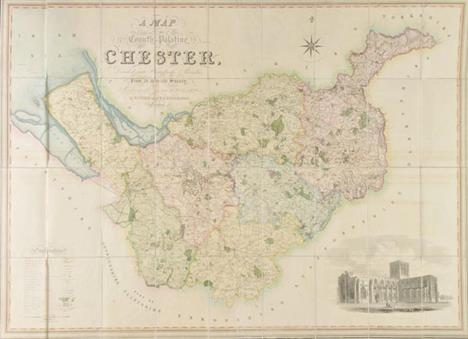
Cheshire. Swire (W. & Hutchings W.F.), A Map of the County Palatine of Chester, Divided into Hundreds and Parishes from an Accurate Survey made in the Years 1828 and 1829, pub. Henry Teesdale, 1830, large engraved map with contemp. hand colouring, sectionalised and laid on linen, calligraphic cartouche, b & w engraved vignette of Chester Cathedral, table of explanation and compass rose, slight staining, marbled endpapers, 970 x 1320mm, contained in contemp. burgundy morocco gilt book box, rubbed and worn at extrems. B.Kentish. A Catalogue of County Atlases of England and Wales 1607 - 1864 and large scale maps. 2012, Item 59 -1


Cornwall. Speed (John), Cornwall, pub. John Sudbury & George Humble, c.1627, uncoloured engraved map, inset view of Launceston, strapwork cartouche and mileage scale, two margins frayed and strengthened on verso, central fold partially strengthened on verso, 385 x 510mm, English text on verso -1

Derbyshire. Saxton (Christopher & Lea Philip), An Exact map of Darbieshire, Corrected and Amended with Additions by P.Lea, c.1693, engraved map with contemp. outline colouring, inset town plan of Derby, three engraved vignettes, strapwork cartouche, trimmed to neat line and laid on contemp. paper, 400 x 495mm. Although the map is unchanged, the legend within the cartouche is a variant and we can find no record of this state. -1
-
109182 item(s)/page