We found 109198 price guide item(s) matching your search
There are 109198 lots that match your search criteria. Subscribe now to get instant access to the full price guide service.
Click here to subscribe- List
- Grid
-
109198 item(s)/page


Lot 1310
Robert Morden, a rare hand coloured 17th Century map of Shropshire, being the 1695 edition before the 1722 corrections (Acton Round is shown as Roundatton); laid down and with a little staining to the edge, framed and galzed (the old inscription to the rear dating this map to 1722 is incorrect), 17 1/2" x 15".


Lot 2200
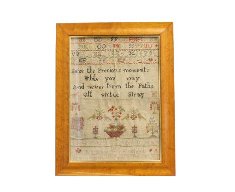
A GEORGE III NEEDLEWORK 'MAP' SAMPLER AND TWO OTHERS. A map sampler of England and Wales showing the counties with floral enclosed title 'A Map of England and Wales, Eliza Gattie, 1803', 64.5 x 50 cm, and two similar samplers, one by Sabina Louisa Lawn, 1842, 32 x 32cm and 38.5 x 27cm. Each framed and glazed. (3)
Lot 350
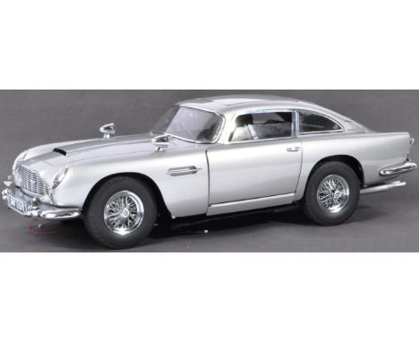
James Bond - A large 1/8 scale Eaglemoss made precision diecast model of James Bond's Aston Martin DB5. Superbly detailed, the original spec for the model includes; working rear and front lights, working horn, ejector seat, accelerator sound effects, brake lights, light up map to interior, machine guns in lights, movable bullet proof rear screen, key ignition, rubber tyres etc. This particular model is unfinished, but does appear complete - including the yet fitted components, roof cover, electrics, Aston Martin cover and other unfitted items. Buyers are reminded to satisfy themselves as to completeness / working order prior to bidding. Once finished, these models make superb and impressive display pieces. Measures approx; 57cm long.


Lot 134
DORSET CARTOGRAPHY: A SMALL QUANTITY OF UNFRAMED MAPS to include an example by Haywood and Sudlow engraved for J Harrison and dated 18th June 1789, a map of the Isle of Purbeck with hand coloured boundary lines with facsimile signature for Colonel Henry James of the Royal Engineers and similar examples (9)Provenance: The Collection of Roy and Anita FurseyBoth scientists, Roy and Anita Fursey were avid collectors of all things Dorset and built their home, Tollys Orchard in Netherbury

Lot 135
ROBERT MORDEN 'Dorset Shire' hand coloured engraved map, sold by Abel Swale, 43cm x 47cm; Blaeu, J., map of the county of Dorset, 'Comitatus Dorcestria sive Dorsettia vulgo Anglice Dorsetshire', for volume IV of the "Atlas Novus", arranged with shields, coats of arms and several galleons, 50cm x 58.5cm; and a map of Weymouth Bay by by Captain Greenvile (or Greenville) Collins, with dedication to Captain George St. Lo, 47cm x 58cm (all unframed)Provenance: The Collection of Roy and Anita FurseyBoth scientists, Roy and Anita Fursey were avid collectors of all things Dorset and built their home, Tollys Orchard in Netherbury


Lot 240
* Embroidered map. England & Wales, by Eleanor Benington, 1797, needlework map of England, Wales, part of Ireland and France, and 3 of the Channel Islands, finely worked on linen, with title, maker's name and date, and place names in black cross-stitch and county borders in cream chain stitch, enclosed in an oval border of tulip flowers worked in long and short stitch in pale pink and yellow, with floral cornerpieces similarly worked, browned and faded, some small holes (mostly to edges), and occasional loss of stitching, 47.5 x 42cm, framed and glazed, 51.5 x 46cmQty: (1)

Lot 241
* Embroidered map. A Map of the World, by Ann Horsnaill, 1795, double-hemisphere world map, finely worked on linen, each hemisphere in blackwork, with land masses outlined in gold coloured silk thread, central decorative circular title and compass rose, and 4 cornerpiece vignettes representing Europe, Asia, Africa, America, all embroidered in black and gold coloured silks, browned and with some overall loss of threads, 39 x 73.5cm, framed and glazed, 46 x 80.5cmQty: (1)


Lot 377
A collection of ephemera and two albums relating to Desmond Dean Arnold, RAF 1654691 India Command, dating from 1943 - 1946, including 1943 RAF diary, Service Overseas booklet, 1942 map of India, Welcome to Bombay booklet, April 1943 from the President of the Hospitality Committee, map of Ceylon, crossing the Equator citation February 1943, the red album entitled Malaya 1945 - 1946, containing hand drawn map, photographs of Japanese planes and prisoners of war, Japanese surrender ceremony in Kuala Lumpur 14.9.45, views of Singapore and Malaya, with The Japanese Government bank notes in Dollars, Cents and Rupees, and matchbox covers, the other floral album containing 1943 - 45 images of South Africa, India, Ceylon, and Victory Day airmen's mess dinner menu 8 May 1945, etc.


Lot 27
Royal Mint 'Voyage of Discovery' presentation pack (from a set of 3) marking 250th Anniversary of Captain James Cook's Voyage of Discovery. This features a brilliant uncirculated UK £2 coin which has a unique design - it spans all 3 coins in the collection and once put together one can see the overall design. The set was released over 3 years, this was coin number one: 1768. On the coin can be seen the stern of Endeavour leaving Plymouth harbour with a map in the background and the number 250 marking the anniversary. Edge inscription reads: OCEANI INVESTIGATOR ACERRIMVS. Still in its original unopened packaging. Good condition. We combine postage on multiple winning lots and can ship worldwide. UK postage from £4.99, EU from £6.99, Rest of World from £8.99

Lot 63
Royal Mint 2013 London Underground UK £2 coin. Created to celebrate London's public rapid transit system's 150th anniversary. Two different coins were created, this one features a 1967 Victoria Line train with perspective being used to bring depth to the train tracks. The edge inscription is unusual, a linear interpretation of the Tube map. Good condition. We combine postage on multiple winning lots and can ship worldwide. UK postage from £4.99, EU from £6.99, Rest of World from £8.99
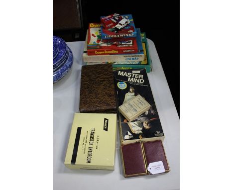
Lot 175
Games, to include Mastermind, Tiddlywinks, Spear's Crayon Stencilling, Waddington's Jig-Map, Tom & Jerry Tiddlywinks, together with a boxed Corgi Ford Transit wrecker, and a Corgi Matra Rancho, Homer 2 Station transistor intercom, boxed cards and score pads marked Harrods, Thos. De La Rue & Co playing cards (qty)


Lot 1
Abeel (David). Journal of a Residence in China and the Neighbouring Countries from 1830 to 1833, revised and reprinted from the American edition..., London: James Nisbet, 1835, half title, folding map with outline colour, advertisement leaf, a little light spotting, Kings Inns Library Dublin ink stamps to title verso and final leaf (offset to opposing leaves), contemporary calf, rebacked, some edge wear and staining, 8vo, together with Martin (R. Montgomery). China; Political, Commercial, and Social, in an official report to Her Majesty's Government, 2 volumes, 1st edition, London: James Madden, 1847, half titles, 3 folding maps (one with outline colour), 4 folding tables (one with water stains and a little frayed), occasional light spotting and offsetting, modern half calf, 8vo, each signed by the author to title, plus Robert Fortune's A Residence among the Chinese, 1857 (ex-libris)Qty: (4)

Lot 115
Americas. Kircher (Athanasius), Mappa Fluxus et Refluxus Rationes in Isthmo Americano, in Freto Magellanico, caeterisque Americae Littoribus Exhibens, Amsterdam, circa 1665, uncoloured engraved map of South America and most of North America, 345 x 405 mmQty: (1)NOTESOriginally published in the Mundus Subterraneous (The Underground World), with its bizarre depiction of a water-filled crater at the source of the Amazon.

Lot 116
Asia Minor. Homann (Johann Baptiste, heirs of), Carte de l'Asie Mineure ou de la Natolie et du Pont Euxin..., Nuremberg, 1743, engraved map with contemporary outline colouring after J. M. Haas, large uncoloured allegorical cartouche, title repeated in Latin above the map, 505 x 595 mm, together with Bowen (Emanuel & Bachiene W. A.). Nieuwe en Naukeurige Kaart van Anatolien of Klein Asien..., 1773, engraved map with contemporary hand colouring, 350 x 430 mm, with Brué (A.). Carte Générale de la Turquie D'Asie de la Perse..., Paris, circa 1840, engraved map with contemporary outline colouring, 370 x 520 mmQty: (3)

![Asia. Solinus (Gaius & Munster Sebastian), Asia Maior, Basel [1538], uncoloured woodblock map originally published in Gai](https://cdn.globalauctionplatform.com/10fe502f-d88e-4615-8dd7-ad5900f01de2/dd642582-46b4-42c6-b857-ad5901111a64/468x382.jpg)
Lot 118
Asia. Solinus (Gaius & Munster Sebastian), Asia Maior, Basel [1538], uncoloured woodblock map originally published in Gaius Solinus's 'Polyhistor, Rerum Toto Orbe Memorebilium Thesaurus Locupletissimus...', below the map is a decorative seascape showing ships being attacked by sea monsters, 250 x 330 mm,Qty: (1)NOTESAn early map of Asia which predates the appearance of Munster's map of Asia in the 'Cosmographia' in 1540. In the upper right corner is a small section of land called 'Terra Incognita', the coastline of North Western America.

Lot 119
Asia. Ottens (Reiner & Joshua), Exactissima Asiae Delineatio in Praecipuas Regiones..., circa 1745, engraved map with contemporary outline colouring, large uncoloured decorative cartouche, 495 x 570 mmQty: (1)NOTESAn uncommon edition of De Wit's earlier map by Ottens. The maps are identical except for the removal of the sailing ships on the Ottens example.

Lot 120
Asia. Senex (John), A New Map of Asia from the latest Observations, Most Humbly Inscribed to the Right Honourable George, Earl of Warrington, circa 1725, engraved map with contemporary outline colouring, inset map of the northern coast of Asia, some toning and water staining to the lower margin, some fraying and short marginal closed tears, slight creasing, 485 x 560 mm,Qty: (1)

Lot 121
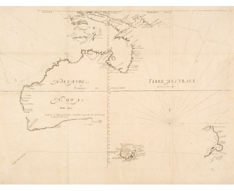
Australia. Bowen (Emanuel), A Complete Map of the Southern Continent Survey'd by Capt. Abel Tasman & Depicted by Order of the East India Company in Holland in the Stadt House at Amsterdam, [1744], uncoloured engraved map, old folds, torn with loss to the upper margin and replaced in facsimile, repaired marginal closed tear, slight soiling and staining, 380 x 490 mmQty: (1)NOTESScarce. The first English map of Australia. Derived from Thevenot's map of 1663. Originally published in John Harris's 'Complete Collection of Voyages'.

Lot 122
Australia. Buffon (George Louis le Clerc), Carte des Déclinaisons et Inclinaisons de l'Aiguille Aimantée Redigée d'après la Table des Observations Magnetiques Faites par les Voyageurs depuis l'Année 1775, Nouvelle Hollande, circa 1780, uncoloured engraved map, old folds, slight staining and dust soiling, slight fraying to left hand margin but not affecting the image, 430 x 535 mmQty: (1)NOTESA French chart of Australia and New Zealand showing the discoveries made by Cook in 1770, during his first voyage and the discoveries made by Capt. Furneaux in Tasmania in 1773. Although complete in itself, the map is the lower-left corner of a much larger four-sheet sea chart of the Pacific Ocean.
Lot 123
Australia. Thevonot (Mechisedech), Hollandia Nova detecta 1644 Terre Australe découverte l'an 1644, Paris, circa 1692, uncoloured engraved map, old folds, one long repaired closed tear affecting image, fold, tear and central fold crudely strengthened and repaired on the verso, 385 x 555 mmQty: (1)NOTESThe final state of Thevenot's seminal map of Australia and which shows the first voyage of Abel Tasman in 1642 - 43. Thevenot's map was the first solely dedicated to the Australian continent. This final edition of the map has the addition of the Tropic of Capricorn and the simplified compass rose and rhumb lines.
Lot 124
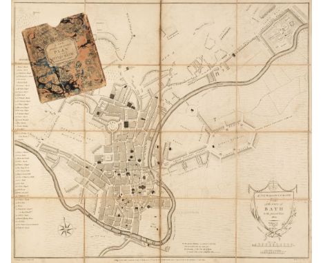
Bath. Chantry (T. Surveyor), A New and Accurate Plan of the City of Bath, A. Taylor & W. Meyler, January 1st. 1801, uncoloured engraved map, sectionalised and laid on linen, key showing 48 places of interest, very slight staining, 465 x 530 mm, contained in a contemporary marbled card slipcase with publisher's printed label to upper cover, slipcase worn and frayed, together with Wright (D.). A Map of the Country round the City of Bath to the Extent of Fifteen Miles and Upwards, C. Goodwin, Sold by the Principal Map and Booksellers in Bath, Bristol & London, June 1st. 1835, uncoloured engraved map, sectionalised and laid on linen, marbled endpapers, 520 x 485 mm, contained in a contemporary marbled card slipcase with publisher's printed label to the upper cover, slipcase worn at extremities, with Greenwood (C. & J. publishers). Untitled Map Sheet of the Environs of Bath & Bristol [1822], engraved map with contemporary outline colouring, sectionalised and laid on linen, a single sheet from the Greenwood large scale map of Somerset, slight offsetting, edged in blue silk, later manuscript ownership signatures and address to verso, marbled endpapers, 475 x 610 mm, contained in a contemporary marbled card slipcase, the slipcase is worn and frayedQty: (3)

Lot 125
Bath. Donne (B.), A New and Correct Plan of the City of Bath from a recent Survey, published by and for H. Goodwin and sold by the Principal Map and Booksellers in Bath, Bristol and London, August 1st. 1810, uncoloured city plan engraved by D. Wright, sectionalised and laid on linen, the cartouche set below a view of the Royal Crescent, compass rose and the coat of arms of the city, slight staining, 450 x 525 mm, contained in a contemporary card slipcase with publisher's label to upper cover, slight staining and wear to the extremities, together with A New and Correct Plan of the City of Bath and Places Adjacent, circa 1750, unattributed and uncoloured engraved map, sectionalised and laid on linen, the map surrounded on all four margins with descriptive text including rules for the Pump Room and the times of the post coaches, some staining, 490 x 400 mm, contained in a modern card slipcase with a printed label to the upper cover and an owner's bookplate to the versoQty: (2)NOTESThe second item described is essentially a guidebook and map, all on one sheet, with useful information for the visitor - such as the rules for using the Pump Rooms - as well as historical facts, all printed in the margins.
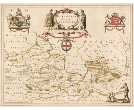
Lot 127
* Berkshire. Blaeu (Johannes), Bercheria vernacule Barkshire, Amsterdam, circa 1648, engraved map with contemporary outline colouring, 385 x 500 mm, mounted, framed and glazed, together with Saxton (Christopher & Hole G.). Comitatus Bercheriae vulgo Barkshyrw qui olim sedes Atrebatum [1610], uncoloured engraved map, large strapwork cartouche, mileage scale and compass rose, slight stainingQty: (2)

Lot 128
* Berkshire. Speed (John), Barkshire Described, J. Sudbury & G. Humble, circa 1627, hand-coloured engraved map, panorama of Windsor Castle, slight overall toning, 380 x 510 mm, English text on verso, mounted, framed and double-glazed, together with Morden (Robert). Barkshire [1695 or later], hand-coloured engraved map, some worming to the margins causing slight loss to the printed margins, some creasing, 360 x 420 mm, framed and glazedQty: (2)

Lot 130
Celestial Chart. Homann (Johann Baptist & Dopplemayer Johann). Globi Coelestis in Tabulas Planas Redacti Pars II. in qua Longitudines Stellarum Fixarum ad Anum Christi, Nuremberg, 1730, hand-coloured engraved celestial chart centred on Pegasus and Cetus (the Whale), with explanatory text to the vertical margins, water-stained and slightly creased, 490 x 585 mmQty: (1)NOTESThe map was originally published in the 'Atlas Coelestis', a collaboration between Homann and Doppelmayr.

Lot 131
Celestial Chart. Homann (Johann Baptist, heirs of), Planisphaerium Caeleste, G. C. Eimmart, circa 1735, engraved twin hemisphere celestial chart with 6 additional celestial projections, the whole displayed on a background of 'clouds', contemporary hand-colouring, 490 x 570 mmQty: (1)NOTESThe second state of this map with the legend ' prostat in Officina Homanniana'. The chart shows the relation between the moon and its influence on tides, the annual illuminations of the earth by the sun and the monthly illumination of the moon.

Lot 133
Colton (Joseph Hutchins) Colton's Atlas of America..., volume 1 (part only) circa 1877, lacking title and preliminaries but retaining index and decorative title, 68 engraved state maps and city plans, all with contemporary outline colouring, several duplicates, slight dust soiling, disbound and lacking boards and spine, each map approximately 410 x 340 mm,Qty: (68)NOTESSold as a collection of maps, not subject to return.
-
109198 item(s)/page