We found 109198 price guide item(s) matching your search

Refine your search

Year

Filter by Price Range
  • List
  • Grid
  • 109198 item(s)
    /page

Lot 1391

An Antique Ordnance Survey map of Hastings, Sussex and Rye and Winchelsea with information verso, (3).

Lot 536

DEBBIE GILLINGHAM, 'CHOCOLATE BOX', an artist's proof print of three chocolate labrador pups, no.17/49, Washington Green blind stamp, numbered, titled and signed in pencil, together with a map of Staffordshire and three modern oils on canvas (5)

Lot 573

TONY KENTUCK, a set of six colour print cartoons relating to the law courts, 30cm x 21cm together with a facsimile print map of Derbyshire and four other framed prints (11)

Lot 574

T.KITCHIN, a new map of the Island of Anglesey, monochrome engraving, printed for R.Baldwin, 18.5cm x 22.5cm, framed and glazed, together with a box of assorted paintings and prints

Lot 697

PICTURES AND PRINTS, to include Leicestershire map, Reg Farmer prints etc (box and eight loose)

Lot 331

A small pull-down school map - Europe by G W Baker and company

Lot 495

A copper topped coffee table depicting a map of the world

Lot 137

Cary (John), Cary's Reduction of his Large Map of England and Wales with Part of Scotland..... Turnpike Roads..... hand-coloured outlines sectionalised in twenty sections laid on linen, marbled covers and slip case, 77 x 63.5cm, 1824.

Lot 138

Mudge (Lt Col. William), Ordnance Survey Map Sheet XXVIII, Island of Lundy, sectionalised and laid on linen, 65 x 94cm, The Tower, 1820, bearing George Folliot label with pencilled "1831 Edn State II, Version 3", in modern hf mor gt book case.

Lot 250

John Archer, two hand-coloured County maps, Lincolnshire, Sidney Hall, Lincolnshire, engraved map; two further hand-coloured maps, Lincolnshire and Derbyshire, after Johnson, all mounted but unframed; together with a collection of books on historic maps and cartography.

Lot 251

Linen backed folding map of Middlesex, published 1st May 1816 by Colonel Mudge, Tower.

Lot 257

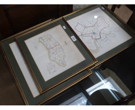
Rare 1784 map, 'Plan Green Area As Laid-out In Lots For Sale City of Lancaster Port Area, River Loyne (or Lune)'; Act of Parliament for Lancaster Port Commission Passed 1750 (23rd Geo.II) Surveyed 1780 Land Purchased from Dalton Family of Thurnham Hall. Construction began 1782, Completed 1787.

Lot 187

A 19th century map of "The Island of Zante", "Ajacio" and "Port Vecchio" a map of Derbyshire, a map of Bedfordshire and another map of Derbyshire (6)

Lot 319

Quantity of motoring manuals including instruction book standard eight, Morris Mini Minor drivers handbook, Operation manual for the Morris 10 - CWT van and truck etc, RAC country road map, quantity of hardback volumes on motoring (3 boxes)

Lot 128

A vintage framed & glazed map of Guernsey c.1970s together with a limted edition Chris Foss print. (2)

Lot 607

Assorted prints inc limited edition, Lincolnshire map and a gilt frame mirror

Lot 523

A mixed lot comprising reproduction map of Warwickshire, a further map of Staffordshire, J Thorley watercolour study 'Alpine Lake', together with two further pictures (5)

Lot 564

Motoring, an interesting Austin Dealership medal celebrating 25 years Associated with "Austin Motor Company Ltd", presented to N.J.Faulkener, Martin & Chillingworth Newbury, in presentation case together with a GWR desk clock (AF) , 1980's RAC Recovery grill badge and Standford folding map. Parcel.

Lot 486

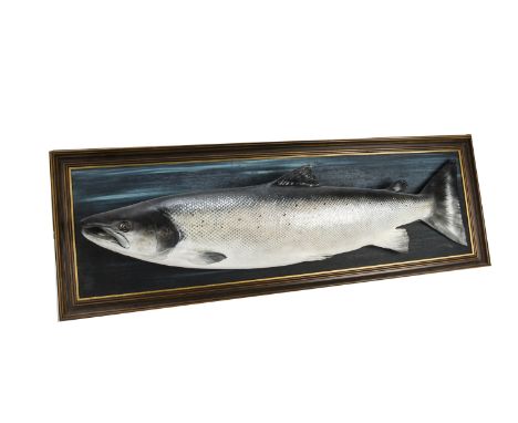
Angling, a Splendid mounted plaster cast of a Salmon caught 14/06/1990 on 'B' beat Tulcan Lodge Estate river Spey, which weighed 27 . 1/2"Lbs together with a limited edition print, "Tulchan" River Spey map, bottom right David Eley 1988, left bottom 12/325 centre design of river route with highlighted places of interest marked along its path.45cm x 64cm framed and glazed.

Lot 289

Sanson Mariette Carte des Trois Arabies, 1654, later coloured Arabian peninsula, framed and glazed, 41 cm x 51 cm, together with a 14th Century later coloured map of Berkshire, dated 1350 and 1387, with decorative Windsor Castle in double frame, 38 cm x 50 cm

Lot 18

Buckingham, James Silk - Travels in Mesopotamia, 1st edition, 2 vols, 8vo, calf, front board to vol I almost detached, loss to lower spine, with folding map (browned), folding plan, folding plate and 27 wood engraved plates, London 1827

Lot 1128

Framed antique black and white ' New and Correct Map of Great Britain ' by Thomas Bowen

Lot 1510

Set of four early 20th Century oak framed coaching prints after Ludovici, together with a framed map of Newcastle and a framed colour print, ' Shipping ' after Charles Dixon

Lot 1531

Small framed antique hand coloured map of Worcester by T. Kitchin

Lot 226

20th Century rolled map of the World (at fault) and a brass dinner gong

Lot 336

Wall hanging railway map of Ireland, dated 1912, together with a publication ' The Railway Age ' 1981

Lot 103

An Auto Car sectional road map of England and Wales

Lot 221

Melvin Brinkley, watercolour study Tide Mill at Woodbridge; and a map of Suffolk

Lot 237

A folder of various unframed prints; and a map of England

Lot 378

Three railway prints; a pencil signed print; an Ordnance Survey map; and two large coloured prints

Lot 2483

A gold pendant, designed as a map of Africa, the front with the initials C.W.A, detailed 750, weight 6.5 gms and a circular devotional pendant, decorated with a central standing figure, surround by three cherubs faces, (2).

Lot 1001

The New Testament, printed by Robert Barker and John Bill, London 1620, quarto, contemporary calf with brass clasps, lacking map and pages of "A Commination" to "The End", rubbed and scuffed, spine bumped and with some loss, writings in a 17th century hand relating to the Woodcock family, recording marriage and births 1668-1689

Lot 1011

Sale, Florentia, Lady - A Journal of The Disasters of Affghanistan, 12mo, half calf, front joint split, with folding map and plan, London 1843

Lot 1024

Littleton, Adam - Linguae Latinae Liber Dictionarius Quadripartitus, 1st edition, rebound, quarto, 4 parts in 1 volume, 1 frontis and 1 map only, London 1678

Lot 1034

Ireland, Samuel - Picturesque Views on the River Wye, quarto, with map, portrait and 30 plates, in a fine "Oasis" green goatskin binding by Roger Powell of Froxfield, the lower front and back covers, gilt lettered with lines from Wordsworth's - "Tintern Abbey", together with a detailed report of restoration work carried out on the book, tipped in at the end, with titled slip case, London 1797

Lot 1388

J & C Walker16th century coloured engravingFolding map of Englands and Wales, London 1860, with slip case, together with Thomas Kitchen - A New Map of Northumberland, in slip case and Stanfords Map of London (3)

Lot 1472

Robert Morden, coloured engraved map of Kent and one other of Asia Minor (trimmed) 37 x 66cm and 49 x 58cm (2)

Lot 1479

Thomas Kitchen, coloured engraved map of Warwickshire, 67 x 52cm

Lot 532

A WWII silk pilots map of Libya and Egypt

Lot 646

A Brookes Travelling Companion map through England and Wales published William Darton 1819, 2nd Edition, backed onto linen

Lot 672

The Voyage of The Fox in the Arctic Seas in Search of Franklin and His Companions by Capt. Sir F Leopold McClintock and published by John Murray 1869, third edition with folding map and other illustrations - library binding

Lot 707

A map of Gloucestershire 26 x 20cm, and a print view of Gloucester after Bartlett - 9 x 14cm

Lot 932

A modern copy of a Blau map of Gloucestershire - 45 x 56cm

Lot 961

A plan map of Philadelphia 1840 - 38 x 30cm

Lot 360

Two vintage map prints one local Preston interest

Lot 37

Two small vintage map plates one depicting Westmoreland and one of Cumberland

Lot 504

A George III embroidered Map of England and Wales, by Eliza Beard, aged 12, 1791, detailing counties, major towns and cities, channels and oceans, with silk thread, 14in x 14in (35cm x 35cm), framed.

Lot 561

After Emanuel Bowen: an 18th century hand coloured engraved map titled 'An Accurate Map of Nottingham Shire, by Eman Bowen, Geog to His Majesty', printed for John Bowles and Rob Sayer, Fleet Street, 72 by 54cm, framed and glazed 78 by 60cm.

Lot 301

A hand built 1/8 scale die cast and ABS plastic replica model Aston Martin DB5, by Eaglemoss Ltd, features include battery operated working rear and front lights, working horn, ejector seat, accelerator sound effects, brake lights, light up map to interior, machine guns in lights, movable bullet proof rear screen, key ignition, and rubber tyres, all features working, 57 by 21 by 16cm, together with the 85 issues of the subscription magazine with detailed construction instructions, an author signed first edition copy of The Most Famous Car in the World - The Complete History of the James bond Aston Martin DB5, by Dave Worrall, pub. Solo 1991, hardcover with dust jacket, and additional Portfolio booklet/brochure with further photographs.Provenance: The Brian Young Collection of Ian Fleming / James Bond Books, Memorabilia and Models.

Lot 261

North Riding - 'Eboracensis Comitatus pars Septentrionalis vulgo North Riding', 17th century map by Christopher Saxton and Gulielmus Hole hand coloured 25cm x 39cm Condition Report Click here for further images, condition, auction times & delivery costs

Lot 262

'A Mapp of Durham', 17th century map hand coloured by Richard Blome 27.5cm x 33.5cm Condition Report Click here for further images, condition, auction times & delivery costs

Lot 110

An 18th Century Coloured Map of Gloucestershire by Robert Morden, 35 x 42 cms

Lot 111

An 18th Century Coloured Map of Nottinghamshire by Richard Blome, 33 x 26 cms

Lot 88

An Early Coloured Map of Warwickshire by Robert Morden, 37 x 42 cms , together with another similar early coloured map of the County of Monmouth by Robert Morden, 37 x 42 cms

Lot 92

An Early Coloured Map of Leicestershire by Robert Morden, 36 x 42 cms, together with another early coloured map of Worcestershire by Robert Morden, 37 x 42 cms

Lot 93

An Early Coloured Map of Durham by Robert Morden, 38 x 42 cms, together with an early coloured map of Nottinghamshire by Robert Morden, 37 x 42 cms

Lot 94

An Early Coloured Map of Wiltshire by Robert Morden, 36 x 42 cms, together with another early coloured map of Westmorland by Robert Morden, 37 x 42 cms

Lot 95

An Early Coloured Map of Shropshire by Robert Morden, 36 x 41 cms, together with another early coloured map of Gloucestershire by Robert Morden, 35 x 42 cms

Lot 96

An Early Coloured Map of Northamptonshire by Robert Morden, 37 x 42 cms, together with another similar early coloured map of Oxfordshire by Robert Morden, 43 x 33 cms

Loading...Loading...
  • 109198 item(s)
    /page

Recently Viewed Lots