We found 109198 price guide item(s) matching your search
There are 109198 lots that match your search criteria. Subscribe now to get instant access to the full price guide service.
Click here to subscribe- List
- Grid
-
109198 item(s)/page


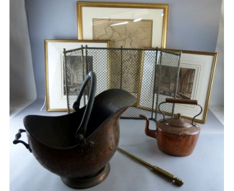
Lot 60
Book: 'De bello civili/M. Annaeus Lucanus Cum Hug Grotii Farnabii notis integris et variorum selectiss Accurante corn. Schrevelio Lugd. Batarorum, Apud Francifcum Hackium.A.1658' incorporating a folding map 'Typus Regionum per quas grabetum eft bellum hoc civile inter Pompeium et Caesarem' 614 numbered pages plus Codicum and Index


![[MISCELLANEOUS] Scott, William. The Riviera, first edition, Black, London, 1907, decorative cloth, top edges gilt, seventy-fi](https://cdn.globalauctionplatform.com/1a49a11c-95e8-47fd-80c4-a47700bd56ae/f2ba6636-c9e7-43d8-ba02-ab473d254ef0/468x382.jpg)
Lot 194
[MISCELLANEOUS] Scott, William. The Riviera, first edition, Black, London, 1907, decorative cloth, top edges gilt, seventy-five paper-protected colour plate illustrations, folding map, four-page publisher's advertisements, quarto (lower board damp marked); Heaton Cooper, A., & Palmer, William. The English Lakes, second edition, Black, London, 1908, decorative cloth, seventy-five paper-protected colour plate illustrations, quarto; and a further twenty-three assorted works, (25).
Lot 250
ASSORTED CIGARETTE CARDS including H.C. Lloyd & Son, 'Academy Gems', 1902, various (3, one creased); Edwards, Ringer & Bigg, 'War Map of the Western Front, Series 2', 1917, (2/54); and Carreras, 'Women on War Work', 1916, (2/50), contained in two albums; together with a quantity of folding Ordnance Survey, Bartholomew, and other maps, (approximately 65).


Lot 1448
Christopher Saxon Map 'Lancashire Brigantum' Hand Coloured & Period From His Famous Book 'The County Maps Of England Depicting The County Of Lancashire & Its Coastline with parts of the West Morland and Cumberland 'Guliel Hole Sculptor with full margins and period hand wash. Late 17th Century, framed, glazed & mounted. 18x18''

Lot 1449
Rare Coastal Chart Map Of Lancashire, Showing The Isle Of Mann And Angelsey, with Vingenettes showing a little & great Ormes and the Chester Ban. Hand coloured wash of the period, cartouche dedicated to the most honourable Si John Lowther Bart, One of the commissioners for executing the office of Lord High Admiral Of England. Full margins. Late 17th Century framed, glazed & mounted. 29x25''


Lot 1467
John Ogilby Frontis Piece From 'The Road Map Book Britania Or An Illustration Of The Kingdom Of England' by John Ogilby esq. London (MDCLXXV) with hand coloured plate from VOL 1 With Cherub Cartouches Of Scrolling Maps And Figures In Landscape. The plates are of the period engraved Byf Barlow/W.Holloway. Dated 1675. Glazed, mounted & framed. 24x20''

Lot 1471
John Ogilby Rare Hand Coloured Period Map Showing The Kingdon Of England & Wales With Royal Cartouches And Royal Crests, and a catalogue of major roads delineated, a new map revised, with full margins, in good original state. By John Ogilby his Majesties Cosmographer. Late 17th Century framed, glazed & mounted.


Lot 1476
Robert Mordem County Map Of The Palatine Of Lancashire, period hand coloured print, framed, mounted & glazed showing Lancashire and its coastline and parts of Cheshire. Sold by Abel Swaleawnsham and John Churchill Late 17th Century. 23x25'' with full margins, from Mordens Famous Folio Of English County Maps Of The Period.


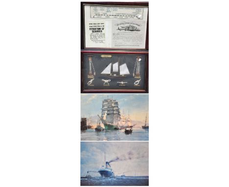
Lot 226
A schematic map of the Liverpool Overhead Railway, a facsimile copy of the notice of closure of the railway and a share certificate of the same company all framed and glazed as one, a framed and glazed montage of a half block miniature ships model together with four rope knots, a print of the Titanic completing her sea trials of Belfast and a further print of the Thermopylae leaving port, the largest 55 x 82cm (4).


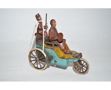
Lot 207
Lehmann, Germany: An Pol 681 lithographed tinplate tri-wheeled vehicle, c.1910, with lithograph transfers (missing umbrella canopy). NB This model was a variation on "The New Century Cycle", commemorating the American explorer Robert E. Peary's reaching the North Pole on the 6th April, 1909, and put the two figures in woollen coats with the umbrella canopy of the topical map of the North Pole.


Lot 348
BRITISH TOKENS, 18th Century Tokens, England, Middlesex, Political and Social Series, Copper Halfpenny (12), Erskine, obv bust of Erskine left, rev inscription, edge plain (DH 1010); Erskine and Gibbs, obv two barristers standing, rev list of jurors, edge milled (DH 1012); Map of France (4), obv the present state of France, rev inscription, CURRENT EVERY WHERE edge, THOMAS CLARKE edge, LANCASTER edge and engrailed edge (DH 1016, 1016a, 1017c, 1017e); General Convenience, obv bust to right, rev shield, edge milled (DH 1018a); Handel, obv bust of Handel left, rev inscription, edge plain (DH 1021); Hardy, obv bust of Hardy left, rev inscription, edge plain (DH 1027); Industry, obv beehive and bees, rev shield, edge plain (DH 1029); Isaac Newton (2), obv bust of Newton left, dot under R, engrailed edge, obv bust of Newton left, no dot under R, edge plain (DH 1033, 1034a). Generally fair to very fine or better, DH1017e cleaned, DH1010 and DH1027 with original colour, DH1016 and DH1029 rare. (12)

Lot 477
COMMEMORATIVE MEDALS, British Historical Medals, George IV, Map of the World, White Metal Medal, c.1820, believed to be by T Halliday for Thomason, the Eastern and Western Hemispheres to either side, Australia named as “NEW HOLLAND”, 74mm (BHM -; Eimer 1139). Extremely fine, only a few signs of porosity, very rare.

Lot 618
COMMEMORATIVE MEDALS, World Medals, Turkey, Italy / Greece, The Capture of Chios and the Fortress of Ciclut (Dalmatia), from the Turks, 1694, White Metal Medal, by Philipp Heinrich Müller, Venetia seated with lion and Liberty Cap on staff, crowned by Victory, mermaids hold a plan and map, RESPUBLICA VICTRIX ARCHIPELAGI DOMINA, rev the moon shines through the constellations onto a seascape of the islands of the archipelago, INTER IGNES LUNA MINORES, 43mm (Voltolini 1101, silver; Ser 149, this medal; Forster 689; MH 97). A lttle flatness to the centre of the reverse, otherwise bright, about extremely fine and extremely rare.


Lot 895
Great War Officers Full Uniform, consisting of Royal Engineers cuff rank tunic, complete with brass regimental tunic buttons, overseas service stripes to the lower cuff. Bronze collar badges. Small style WW1 medal ribbons pin to the chest. Tunic is accompanied by a pair of officers whip cord breeches. Displayed with a selection of WW1 period equipment including Sam Browne belt and cross straps, officers field binoculars in 1918 dated leather case, haversack, map case, pistol holster, ammunition pouch, riding crop, officers brown leather boots, water bottle (post WW1 period), lanyard and 1916 dated trench whistle. The tunic is also complete with an early pattern officers peaked cap with short peak. Set is mounted onto a display mannequin (female). Sadly the tunic and breeches are severely damaged by moth, the worst of this is covered when displayed with the equipment. The leather equipment also shows some wear and is dry in places.


-
109198 item(s)/page