We found 108737 price guide item(s) matching your search

Refine your search

Year

Filter by Price Range
  • List
  • Grid
  • 108737 item(s)
    /page

Lot 116

Sussex. Norden (John & Speed, John), Sussex described and divided into Rapes with the situation of Chichester the cheife citie and the armes of such Nobles as have bene dignified with the title of Earles since the Conquest and other accidents thereon observed, by John Speed & George Humble, circa 1627, hand coloured engraved map, inset town plan of Chichester, good margins, 385 x 505 mm, English text on versoQTY: (1)

Lot 48

England, Wales & Ireland. Speed (John), The Invasions of England and Ireland with al their Civill Wars since the Conquest, Thomas Bassett & Richard Chiswell, circa 1676, hand-coloured map, engraved by Cornelius Danckerts, large compass rose and numerous rhumb lines, good margins, 380 x 515 mm, English text on versoQTY: (1)NOTE:R. W. Shirley. Early Printed Maps of the British Isles, 1477 - 1650, number 397.

Lot 253

Wilson (Henry, foreword). An Examination of the Cause of the Outbreak in Mesopotamia, with an indication of some of the main factors underlying the disturbed state of the whole Middle East, London: H. M. Government, October 1920, folding map at rear, a few light spots, original red wrappers, staples perished with small portion of wear to upper cover, 4toQTY: (1)NOTE:Exceedingly scarce. The foreword states 'It is hoped, however, that the paper may serve as a basis from which to examine Near and Middle Eastern developments as a whole and as a definite unit in world politics'.

Lot 114

St. Petersburg. Unvertzagt (G. I.), Plan der Kayserl Residentz Stadt St Petersburg, published by The Academy of Sciences in St. Petersburg, circa 1745, uncoloured city plan engraved by Unverzagt for J. N. De L'Isle, title in Cyrillic and German, descriptive text below the map identifying 98 separate locations in Russian and German, slight creasing, one repaired closed tear, 470 x 630 mmQTY: (1)NOTE:A scarce plan of St. Petersburg that was copied by M. Seutter and T. C. Lotter.

Lot 479

Speke (John Hanning). Journal of the Discovery of the Source of the Nile, 1st edition, Edinburgh: William Blackwood and Sons, 1863, numerous engraved illustrations, folding map to the rear pocket, later endpapers, some spotting & light toning, rebound with red cloth spine retaining original gilt decorated brown cloth boards & spine, slightly rubbed, 8vo, together with:Stanley (Henry M.), Through the Dark Continent..., 1st edition, 2 volumes, London: Sampson Low, et al, 1878, monochrome illustrations & colour maps, bookplate to the front pastedowns, gutters re-enforced with tape, some light toning & spotting throughout, rebound with later brown cloth spines retaining original gilt decorated brown cloth boards & spines, slightly rubbed to head & foot with some minor loss, 8vo, plusNorris-Newman (Charles L.), With the Boers in the Transvaal and Orange Free State in 1880-1, 2nd edition, London: Abbot, Jones & Co., circa 1890, colour & monochrome folding maps & plans, minor marginal toning, original green cloth, boards & spine very lightly rubbed & marked, 8vo, and other late 19th & early 20th century history & travel reference, all original cloth/boards, G/VG, 8vo/folioQTY: (6 shelves)

Lot 626

Wallace (Alfred Russel). Journal of the Proceedings of the Linnean Society. Volume IV, number 16, Zoology, London: Longman, Green, Longmans and Roberts and Williams and Norgate, 1860, pp. 145-189, in which On the Zoological Geography of the Malay Archipelago, by Alfred R. Wallace. Communicated by Charles Darwin Esq., pp. 172-184, partly unopened, original wrappers, some fading, 8v0, together with Darwinism. An exposition of the theory of natural selection with some of its applications, 1st edition, London: Macmillan and Co., 1889, portrait frontispiece, folding map, wood-engraved illustrations, advertisement leaf at rear, light spotting to half-title and endpapers, contemporary owner inscription of Rothsay Stewart, 1889 to half-title, original green cloth, spine darkened, tear at head of spine, 8vo, plus The Wonderful Century, its successes and its failures, 1st edition, London: Swan Sonnenschein, 1898, portrait frontispiece, 12 folding graphs at end, a little light soiling front and rear, bookplate of John Jackson Coates, his signature, original green cloth gilt, spine a little darkened and rubbed at ends, 8vo, with 2 others: Man's Place in the Universe, 1st edition, 1903, and The Malay Archipelago, new edition, 1898QTY: (5)

Lot 138

World. Wyld (James), The World on Mercator's Projection..., 1861, engraved map with contemporary outline colouring, sectionalised and laid on linen, slight staining and dust soiling, short repaired closed tears affecting the lower right corner, red cloth endpapers, 640 x 945 mm, contained in a contemporary cloth slipcase with publisher's printed label to the upper cover, some wear to the slipcaseQTY: (1)

Lot 39

Devon. Bowen (Emanuel), An Accurate Map of Devon Shire Divided into its Hundreds, Drawn from the best Authorities, assisted by the most approved Modern Maps..., Carington Bowles & Robert Sayer, circa 1765, engraved map with contemporary outline colouring, large uncoloured decorative cartocuhe, inset map of Plymouth, slight creasing to the central fold, 540 x 685 mmQTY: (1)NOTE:Batten & Bennett, The Printed Maps of Devon, number 37. Originally published in 'The Large English Atlas'.

Lot 429

[Morris, Reginald O. & Sir Alexander Kaye Butterworth]. George Butterworth 1885-1916, printed for private circulation only, York & London: Delittle, Fenwick & Co, Fine Art Printers, 1918, portrait frontispiece, 4 plates, map, small abrasion to front pastedown, original contrasting buckram, tears at spine ends, some small stains, small 4toQTY: (1)NOTE:Very scarce memoir of the composer George Butterworth {1885-1916), by his father Sir Alexander Kaye Butterworth friend and fellow soldier Reginald Morris.George Butterworth is best remembered for composing A. E. Housman's A Shropshire Lad (1911-12) and The Banks of Green Willow (1913), among others and collected folk songs with Ralph Vaughan Williams in the English countryside in 1907, also later working with Hubert Parry. At the outbreak of the First World War he was commissioned as 2nd lieutenant in the 13th Battalion Durham Light Infantry and awarded the Military Cross for his action in capturing trenches at Pozieres on the Somme, July 16-17, 1916. He was killed on 5 August.

Lot 578

Huxley (Leonard). Life and Letters of Sir Joseph Dalton Hooker, 2 volumes, 1st edition, London: John Murray, 1918, portrait frontispieces. folding map of Sikkim and Eastern Nepal, half-tone illustrations, a little minor spotting, bookplates of Maurice Francis Yorke, original navy cloth gilt, one or two small bumps, 8vo, together with Darwin (Francis, editor). The Life and Letters of Charles Darwin, including an autobiographical chapter, 3 volumes, 1st edition, London: John Murray, 1887, portrait frontispieces, facsimile letter, some minor toning and spotting, hinges tender, bookplates of Sir John Lubbock, original cloth, spines a little darkened, a few damp stains to covers, residue from label removal to volume IIi upper cover, 8vo, plus More Letters of Charles Darwin. A Record of his work in a series of hitherto unpublished letters, edited by Francis Darwin, 2 volumes, 1st edition, London: John Murray, 1903, photogravure and half-tone illustrations, a little light spotting and toning, top edge gilt, original cloth gilt, a little rubbed, 8vo, together with other biography, letters etc including Alfred Russel Wallace Letters and Reminiscences, by James Marchant, 2 volumes, 1916, and T. H. Huxley's Diary of the Voyage of H. M. S. Rattlesnake, edited from the unpublished ms. by Julian Huxley, 1st edition, 1935 (2 copies)QTY: (20)NOTE:The second work is from the library of Sir John Lubbock (4th Baronet, 1834-1913), politician and polymath, who received a letter from Charles Darwin in July 1870 regarding the Census and consanguineous marriages (letter published on p. 129 in volume III).

Lot 127

Warwickshire and Leicestershire. Saxton (Christopher), Warwic Lecestriaeq. Comita Civitat. Oppidoru. Villaru. Fluminu. Ceterarumq. Rerum omnium in eisdem memorabilium, nova, veraq. descriptio, [1579], engraved map by Leonard Terwoort, contemporary hand colouring with some later enhancement, elaborate strapwork cartouche and mileage scale, the latter surmounted by dividers, coat-of-arms of Elizabeth I with the addition of the heraldic crest of Thomas Seckford, some oxidization causing small areas of cracking and splitting and slight loss, trimmed to decorative margin and laid on later card, slight staining, 390 x 520 mm, framed and glazedQTY: (1)NOTE:The first printed map of Warwickshire and Leicestershire from the earliest national atlas of England and Wales.

Lot 227

Adams (Robert). The Narrative of Robert Adams, A Sailor, who was wrecked on the Western Coast of Africa, in the year 1810, was detained three years in slavery by the Arabs of the Great Desert, and resided several months in the city of Tombuctoo, 1st edition, London: John Murray, 1816, engraved folding map frontispiece (closed tear along one fold), spotting, contemporary half calf gilt, upper cover and front free endpaper loose, lower joint cracked with cover loosening, some wear to extremities, 4toQTY: (1)

Lot 7

Arrowsmith (John). The London Atlas of Universal Geography exhibiting the Physical & Political Divisions of the Various Countries of the World, Constructed from Original Materials. London: J. Arrowsmith, 10 Soho Square, 1842, calligraphic title page with late 19th-century ownership inscription, preface and contents present, 66 folding maps (16 not mentioned in contents page) all with contemporary outline hand colouring including Texas (2nd state), 1843, Acquisitions of Russia since the Accession of Peter 1st, 1842, Ionian Islands & Malta, 1844, West Coast of Africa Expedition of Captain Trotter, 1813, Australia East and West, 1846, The World on Mercator's Projection, 1844, England and Wales, The Inland Navigation, Rail Roads, Geology & Minerals, 1845, India, 1842, Burma, Siam & Cochin China, 1842, British North America, 1846 and others showing parts of Europe, Asia, Americas and the World, edges frayed with some loss to title page, preface and contents, splitting at folds to most maps (largest being 360 mm) and some marginal tears (not Texas), dust soiling to title tabs, boards detached and worn, spine lacking, folio QTY: (1)NOTE:An early edition of one of the greatest 19th-century English atlases. This particular atlas is enhanced by 16 additional Arrowsmith maps, some being his scarcest and most important including the rare 2nd state 1843 Texas map titled; Map of Texas compiled from Surveys recorded in the Land Office of Texas, and other Official Surveys…, Recognised as an Independent State by Great Britain, 16th Nov, 1840. The map shows the seals of the Republic of Texas and the General Land Office of Texas beneath the title plus two insets of Galveston Bay and the geographical relationship of Mexico, Texas and the United States before the Mexican War. This map was the best available information on Texas during the decade when the political fate of the new Republic was of international concern. The information on geographical features, roadways, location of Indian tribes and the latest political divisions for the map was provided by the General Land Office of Texas.

Lot 27

British Isles. De Wit (Frederick), Novissima prae caeteris aliis accuratissima Regnorum Angliae Scotiae Hiberniae..., Amsterdam circa 1690, engraved map with contemporary outline colouring, inset map of the Orkney, Faroes and Shetland Islands, decorative cartouche and mileage scale, slight oxidisation to old watercolour causing small cracks and splits, repaired on verso, occasional marginal closed tears, 590 x 500 mmQTY: (1)NOTE:R. W. Shirley. Printed Maps of the British Isles, 1650 - 1750. De Wit 6, state 2.

Lot 524

Darwin (Charles). Geological Observations on the Volcanic Islands and Parts of South America visited during the Voyage of H.M.S 'Beagle'..., 2nd edition, London: Smith, Elder & Co, 1876, half-title, 4 folding plates (including 1 map) in-text illustrations throughout, ownership inscription to verso of front free endpaper, minor spotting to first and last few gatherings and plates, sewing weakening in places, hinges tender, original publisher's green cloth gilt, slightly rubbed to joints and edges, 8vo, together with;The Different Forms of Flowers on Plants of the Same Species..., 2nd edition, London: John Murray, 1880, minor spotting to first and last few gatherings and plates, sewing weakening in places, original publisher's green cloth gilt, minor rubbing to joints and edges, 8vo, plus;The Expression of the Emotion in Man and Animals..., London: John Murray, 1901, illustrations, bookplate of Herbert Chatterton to front pastedown, slight spotting throughout, original publisher's green cloth gilt, minor rubbing to joints and edges, 8vo and 7 other works, all in original green cloth gilt and slightly rubbed QTY: (10)

Lot 279

Bacon (G. W. publisher). Bacon's Large Scale Atlas of London and Suburb (revised Edition) with an Alphabetical Index..., circa 1920s, title and contents list, contents page with long closed repaired tear, 7 lithographic double-page county maps, 20 maps of London, index map and 35 sheet map of London, publisher's half morocco, worn and bumped, folio, together with Bacon's Popular Atlas of the British Isles..., 1907, additional half-title, preface and contents, 72 double-page colour lithographic maps and diagrams and charts, upper hinge weak, publisher's decorative gilt cloth, a little frayed along the spine, folio, with Bacon's General Atlas of the World with Index, circa 1930, title and contents, frontispiece of national flags and 49 double-page colour lithographic maps, index bound at rear, manuscript presentation inscription to first front blank, hinges weak, contemporary half morocco gilt, worn and rubbed at extremities, folioQTY: (3)

Lot 242

Elphinstone (Mountstuart). An Account of the Kingdom of Caubul, and its dependencies in Persia, Tartary, and India; comprising a view of the Afghaun Nation, and a history of the Dooraunee Monarchy, 2 volumes, 2nd edition, London: Longmans, Hurst, Rees, Orme, and Brown, 1819, engraved folding map in volume one, folding engraved plate to folding two, 12 further hand-coloured plates, heavily spotted and offset, front hinges cracked and separated, ex-library with stamps to foot of titles, 20th-century red half cloth gilt, backstrips faded, library reference numbers to foot of spine, some wear, 8voQTY: (2)

Lot 238

Clapperton (Hugh). Journal of a Second Expedition into the Interior of Africa from the Bight of Benin to Soccatoo... To which is added the journal of Richard Lander from Kano to the sea-coast, partly by a more eastern route, 1st edition, London: John Murray, 1829, mezzotint portrait frontispiece, single-page plan and folding engraved map all laid down on linen, some spotting to plates, offsetting to title, some light marginal soiling, modern cloth-backed boards, 4to, together with [Skinner, John]. A True Relation of the Unjust, Cruell and Barbarous Proceedings against the English at Amboyna in the East-Indies, by the Neatherlandish governour and councel there, part 1 only (of 3), 2nd impression, London: [H. Lownes for N. Newbery, 1624], part 1 only, 38 pp., lacking woodcut frontispiece, title imprint shaved, upper corner of title repaired, some soiling and spotting, later half calf, rebacked, edges rubbed, 8vo QTY: (2)

Lot 44

East Indies & Asia. Covens (J. & Mortier C.), L'Asie divisée en ses Principales Regions..., Amsterdam, circa 1740, engraved map with contemporary outline colouring, decorative cartouche and mileage scales, title repeated in Latin in the upper margin, slight staining, 495 x 590 mm, together with Valentyn (Francois). Kaart van de Zuyd-Ooster Eylanden van Banda. J. Van Braam en G.O. Linden exc. cum Privil. [1724 - 26], uncoloured engraved map, originally published in 'Oud en Nieuw Oost-Indien', old folds, 450 x 555 mm, with Waldseemueller (Martin & Fries Laurent). Tabula II Asiae hae sunt Cognitis Totius orbis (title on verso), circa 1522, uncoloured woodblock map, toned overall, slight worming but confined to the margins, 300 x 375 mm, several woodcut devices and Latin text to verso, with another 45 maps similar, including examples by or after Merian, Bellin, Moll, Hall, Mallet, Prevost, De Vaugondy, Bonne, Rapin/Tallis, Johnson, Van der Aa, Mitchell, Cowperthwait, J & C Walker, Weller, Stockdale, Levasseur and Thomson, several duplicates, various sizes and condition, plus eleven topographical views, natural history and portraits, various sizes and conditionQTY: (59)

Lot 103

North America. Pinkerton (John), Spanish Dominions in North America, Northern Part, Cadell & Davies & Longman, Hurst, Rees, Orme & Brown, 1811, double-page engraved map with contemporary wash colouring, 515 x 705 mm, together with Discoveries of Capts. Ross Parry & Franklin in the Arctic Regions, circa 1842, unattributed engraved map with contemporary outline colouring, some offsetting, 305 x 445 mmQTY: (2)NOTE:A map of Spanish territorial holdings in North America by the Scottish cartographer and antiquarian John Pinkerton (1758-1826). Regions depicted include California and much of the southwestern United States, as well as French-occupied Louisiana and the northern portion of modern Mexico. The map details major topographical features and the locations of various Native American peoples, farms, mines, and military garrisons. Published as part of Pinkerton's Modern Atlas.

Lot 293

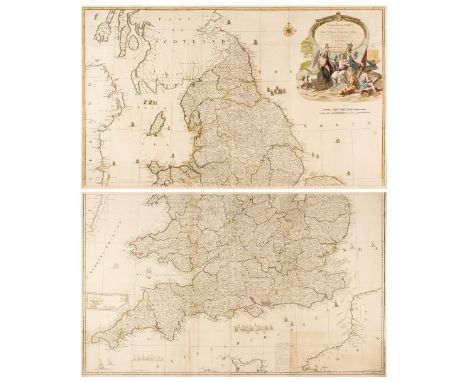
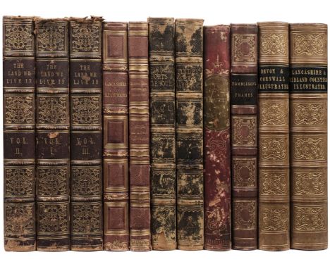
Tombleson, (William & Fearnside William Gray). Tombleson's Thames, London: Tombleson & Co. circa 1850, decorative title, dedication and preface, 79 (complete) uncoloured engraved plates, with tissue guards, lacking the folding map, some spotting throughout, marbled endpapers, contemporary half calf, gilt decorated spine, worn at extremities, 4to, together with Britton (J. & Brayley E. W.). Devonshire & Cornwall Illustrated from Original Drawings by Thomas Allom, 2 volumes bound in 1, W. H. Bartlett &c. H. Fisher, R. Fisher & P. Jackson, 1832, additional decorative half-titles, and additional title, two uncoloured engraved maps of Devon and Cornwall, 136 engraved views on 68 sheets, each with tissue guard, all edges gilt, contemporary gilt decorated calf, slight wear to extremities, 4to, with Allen (Thomas). Lancashire Illustrated from Original Drawings by S. Austin, J. Harwood and G. & C. Pyne &c. &c. London: H. Fisher, R. Fisher and P. Jackson, 1832, bound with The Midland-Counties Tourist. Seventy-three views in the Counties of Derby, Chester, Leicester, Lincoln, Nottingham and Rutland, Fisher Son & Co. 1837, additional decorative half-titles to each volume, 176 views of 84 sheets, each with tissue guard, all edges gilt, contemporary gilt decorated calf, slight wear to extremities, 4to, uniform with the previous item, with another copy similar bound in 2 volumes in contemporary half morocco gilt, worn at extremities, 4to, plus Bartlett (W. H. Harding J. D. T. Creswick and others). The Ports, Harbours, Watering Places and Picturesque Scenery of Great Britain, 2 volumes, Virtue & Co. circa 1840, additional decorative title to each volume, 140 uncoloured engraved plates, some spotting and slight water staining throughout, marbled endpapers, all edges gilt, contemporary half morocco gilt, heavily worn, 4to, and Leighton (John M.). Strath-Clutha or the Beauties of Clyde..., Glasgow, Joseph Swan, circa 1840, decorative calligraphic title, preface and dedication, 80 uncoloured engraved plates on India wove, on 39 sheets, contemporary half calf with gilt decorated spine, upper board detached, and Orr (William S. publishers). The Land We Live In..., 3 volumes, circa 1865, engraved map of the British Isles, numerous wood and steel engravings, some spotting and staining throughout, contemporary half morocco gilt, heavily worn, 4to, QTY: (11)

Lot 124

Wales. Speed (John), Wales, Thomas Bassett & Richard Chiswell [1676], hand-coloured engraved map, twelve oval vignettes of principal cities to the vertical margins and inset views of Bangor, St. Davids, Llandaff and St Asaph, good margins, central fold strengthened on verso, slight mount staining, 385 x 510 mm, English text on versoQTY: (1)

Lot 24

* Bowen (Emanuel). An Accurate Map of Gloucestershire Divided into Hundreds..., R. Sayer & J. Ryall, H. Overton, Carington Bowles, J. Bowles and H. Parker [and] An Accurate Map of Derby Shire Divided into its Hundreds..., T. Kitchin, R. Sayer, J. Ryall, H. Overton, Bowles & Son and Messrs. Bakewell & Parker, circa 1762, two engraved maps with contemporary outline colouring and some later enhancement, light overall toning, each approximately 505 x 415 mm, uniformly mounted, framed and glazedQTY: (2)NOTE:Both maps were published in the scarce 'Royal English Atlas'.

Lot 45

England & Wales. Rocque (John), England and Wales Drawn from the most accurate surveys, Containing all the Cities, Boroughs, Market Towns and Villages..., circa 1794, large engraved map with contemporary outline colouring on two sheets not conjoined, large cartouche with later hand-colouring, inset map of the Scilly Isles, old folds, slight offsetting and spotting, overall size 1200 x 985 mm, together with Kitchin (Thomas). A New Map of England & Wales Drawn from Several Surveys &c. on a new Projection Corrected from Astronomical Observations..., The Canals inserted to 1792 by J. Phillips Surveyor, Laurie & Whittle, 12th May 1794, large engraved map with contemporary outline colouring on two sheets not conjoined, inset map of the Scilly Isles, large uncoloured decorative cartouche, the cartouche incorporates a coastal scene with a ship, a soldier and a sailor and a spread of artefacts representing British trades, including sheep, wheat and cannonballs, compass rose and table of remarks, slight dust soiling, old folds, overall size if conjoined 1275 x 1090 mmQTY: (4)

Lot 3

* Africa. De L'Isle (Guillaume), Carte D'Afrique Dressée pour l'usage du Roy..., Paris, 1722, engraved map with contemporary outline colouring and some later enhancement, 495 x 650 mm, mounted, framed and glazedQTY: (1)NOTE:R. V. Tooley. Collectors Guide to Maps of the African Continent, page 68.

Lot 172

A map - Somersettensis, Saxton & Kipp, hand coloured engraving 29cms x 39cms, framed

Lot 326

A large historiacal oak framed map of the United States

Lot 148

Hutchinsons, 'History of Durham', in three volumes and a map of Northumberland

Lot 324

Map of Northumberland and three engraved prints

Lot 140

Robert Morden map of Durham and a watercolour

Lot 763

An 18th century hand coloured 'Accurate Map of the County of Essex' by Eman Bowen, 73cm x 54.5cm, framed and glazed.

Lot 149

An early 20thC Dutch fabric school map of Palestine, scale 1/280.000, printed Tegyduc Wakken, 114cm x 99cm.

Lot 296

A German Third Reich Kriegsmarine cap tally, together with a Gustav Nestler map reader. (2)

Lot 61

C Greenwood, County of Kent, vol 1, and epitome of county history, with illustrated map, half calf with feathered boards, printed by Dennett for the proprietor, at Bloomsbury Square London 1838.

Lot 391

After Christopher Saxton. Map of Rutland (Rutlandiae), hand coloured engraving, by William Kip, 7cm x 21cm together with a map of Worcestershire, engraved by W.R. Toms, published 1742, 15cm x 15cm. (2)

Lot 281

A group of England and Wales maps, including Ordnance Survey, Bartholomew's, Reynolds New Distance map of London and visitors guide, Geographia large scale plan of Manchester, Henstock & Faulkes' cycling map of seventy miles about Liverpool, further maps and guides. (qty)

Lot 15

A late 18thC Bowles's New Travelling Map of England and Wales, exhibiting all the direct and principle cross roads: with the distances in measured miles, printed for the proprietors Bowles and Carver, number 69, with slipcase, 61.5cm x 54.5cm.

Lot 1053

1877 A.D.. Edwin W. Streeter - Gold: Legal Regulations for the Standard of Gold & Silver Wares in Different Countries of the World - Chatto & Windus, London, 1877 - hardback, cloth cover with blocking and gold titling - 140 pp, fold-out map. 333 grams, 19.5 x 13.5 cm (7 3/4 x 5 1/4 in.). Property of a Kent, UK, collector. [No Reserve]

Lot 1024

1878 A.D.. Edwin W. Streeter - Gold: Legal Regulations for the Standard of Gold & Silver Wares in Different Countries of the World - Chatto & Windus, London, 1877 - hardback, full leather binding with gold blocking and titling, marbled endpapers - 140 pp, fold-out map. 353 grams, 18.5 x 12.7 cm (7 1/4 x 5 in.). Property of a Kent, UK, collector. [No Reserve]

Lot 3021

1892 reprinted 1968 A.D.. Henri De La Tour - Atlas de Monnaies Gauloises - Plon, Nourrit et Cie., Paris, 1892 (1968 reprint) - hardback, cloth covers, gold titling to spine - 12pp, 55 plates, map. 725 grams, 33.8 x 24.6 cm (13 1/4 x 9 3/4 in.). Property of a Kent, UK, collector. [No Reserve]

Lot 3026

1817-1819 A.D.. Ruding, Rev. Rogers - Annals of the Coinage of Britain and its Dependencies - Nichols, London (large paper second edition in four volumes); volume 1: preface xxxv pp.; text 518pp.; volume 2: text 532 pp.; volume 3: preliminaries xxxvi pp., text 542pp., general index 42pp.; volume 4: supplement to first edition 88pp.; folding map; 52 plus 19 plates.; supplementary 6 plus 16 plates; original full red morocco gilt spines, all edges gilt; armorial bookplates (Goff?) and previous owner label. Fine condition; spines faded and leather dry but sound. An attractive set. 10.4 kg total, 30 x 24.5 cm each (11 7/8 x 9 5/8 in.). Property of a Kent, UK, collector. [4, No Reserve]

Lot 2977

1864 A.D.. Peter Whelan - The Numismatic Atlas of the Roman Empire - fold-out map in hardback with cloth covers, foundation moulding, pasted label with 'C.J. Whistler Hanson' typed notation. 205 grams, 23 x 15 cm (9 x 5 7/8 in.). Property of a Kent, UK, collector. [No Reserve]

Lot 1991

1908 A.D.. Victoria County History of Kent-Vol I - Archibald Constable & Co., London, 1908 - hardback, cloth covers, gold titling to spine, library binding - 518 pp, text figures, fold-out map, colour and monochrome plates; one page detached. 2.49 kg, 30.5 x 23 cm (12 x 9 in.). Property of a Kent, UK, collector. [No Reserve]

Lot 1037

1901 A.D.. John Earle - The Alfred Jewel - Clarendon Press, Oxford, 1901 - hardback, cloth covers, gold titling to spine and front cover - 196 pp, fold-out map, gilt and polychrome frontispiece - ex Dudley public library. 682 grams, 22.5 x 18 cm (8 7/8 x 7 in.). Property of a Kent, UK, collector. [No Reserve]

Lot 3002

1835 A.D.. Joachim Lelewel - Numismatique du Moyen-Age Considérée sous le rapport du Type - Atlas - Straszewicz, Paris, 1835 - hardback with leather spine and marbled boards, gold block titling to spine - 25 plate on 24 sheets, hand-coloured map. 543 grams, 29 x 23 cm (11 1/2 x 9 in.). Property of a Kent, UK, collector. [No Reserve]

Lot 1014

1852-1880 A.D.. C. Roach Smith - Collectanea Antiqua, etchings and notices of ancient remains, illustrative of the habits, customs, and history of past ages. Volumes I, II & VII - privately printed - hardback, half-calf binding with marbled boards, gold titling to spine, marbled endpapers, gilt edging - each volume circa 300 pp. with numerous text figures and plates, Vol.I with fold-out map of Sittingbourne excavations, Vol.II with fold-out map of villa excavations at Hartlip; all with ex Libris Spencer Charles Ferguson bookplates. 2.37 kg total, 22.5 x 15 cm each (8 7/8 x 6 in.). Property of a Kent, UK, collector. [3, No Reserve]

Lot 3028

1846 A.D.. Hildebrand - Svenska Kongl. Myntkabinettet i AngloSachsiska Mynt (First Edition) - Norstedt & Soner, Stockholm, 1846 - card covers, 332 pp, 10 plates, fold-out map. 1.04 kg, 27 x 22 cm (10 5/8 x 8 3/4 in.). Property of a Kent, UK, collector. [No Reserve]

Lot 1032

1855 A.D.. William Bowman - Part VI. Reliquiae Antiquae Eboracensis or Remains of Antiquity Relating to the County of York - Cooke & Clarke, Leeds, 1855 - hardback,quarter-bound in leather - 96 pp, text figures, fold-out map. 609 grams, 29 x 23 cm (11 1/2 x 9 in.). Property of a Kent, UK, collector. [No Reserve]

Lot 3027

1864 A.D.. Peter Whelan - The Numismatic Atlas of the Roman Empire - fold-out map in hardback with cloth covers, foundation moulding, pasted label. 240 grams, 23.5 x 14.8 cm (9 1/4 x 5 3/4 in.). Property of a Kent, UK, collector. [No Reserve]

Lot 255

A collection of seven early to mid 20th century silver plated & brass cigarette cases. To include an RMS Queen Mary cigarette 'Monopol' case with lighter having coloured UK map with ship design to external lid by Colibri (boxed), a sky blue brass twin hinged case - made in England, three with scrollwork and engine turned decoration - two marked Supreme and one bearing PAT No. 216418 with faux tortoise, one brass with royal blue enamel cased lid with engine turned reverse by Melissa - England. Two initial engraved. Largest measures 14cm (length). 

Lot 481

Map. 1922 Ordnance Survey One Inch of Bristol District. Special Sheet Popular Edition. Includes Glos, Wilts & Somerset. Redwick at NW then Avonmouth, Iron Acton, Chipping Sodbury, Colerne at East, Farleigh Hungerford at SE, West Harptree at South, SW with Winscombe and Clevedon at West on Bristol Channel. Cloth backed.

Lot 43

Interesting Second World War selection of documents from Hamburg, relating to a sailor going absent without leave and denoting what his charges are, including a photograph of the sailor and map of Hamburg. Rough translation reads: The Standard Bearer left the Marine Lazarett Hospital Hade Marrschen on 10-06-45 Where he was stationed for treatment without the doctors agreement. He returned on 11-06-45 after 10 hours. The facts of the case are: 1.) Unauthorized distance from the Squad (Absent without leave). 2.) A Violation against the Hospital discipline/orders. [There is a suggestion that his bride will also be sentenced accordingly, which could mean he left to be married] Signed by Chief Doctor.

Lot 128

Wyld (James), A Map of the Superficial Geology of the British Isles......Railways......and......Steam Packet Routes, hand-coloured and laid on linen, 130.5cm x 102cm, (no slip case).

Lot 231

Paul Kidby - ‘Non Timetis Messor’, from Terry Pratchett’s Discworld Novels, limited edition 260/950, signed in pencil, in frame, 35 x 47cms overall; together with another Paul Kirby Discworld poster; and a Discworld map, each framed. (3)

Lot 443

Map, A 19th century map of Hampshire, fold line to centre, framed, 74cm by 63cm

Lot 568

John Speed (1552-1629) "Cardiganshyre", (Cardiganshire Wales) a handsomely hand-coloured early antique edition of this map of Cardiganshire as surveyed by Speed in 1610. 39 cm by 52 cm. Well framed. Together with three unframed Victorian maps one of Monmouthshire, one of Kirkcudbright, one of Kincardine and the last of "Germany under the Hohenstaufens" (5 prints in all)

Lot 1164

Miscellaneous pictures and prints, including a reproduction 19th c map of Liverpool, watercolour Continental street scenes, still lifes, etc

Lot 796

A folio of Old Master and other prints, 18th c and later, including Giovanni Battista Piranesi (1720-1778) - Veduta dell' Arco di Costantino, e dell' Anfiteatro Flavio detto il Colosseo, from 'Vedute di Roma', n.d. [18th c], engraving, repaired, 41 x 55cm, Carlo Lasinio (1759-1838) - Napoleon's Coronation; Napoleon and his wife Marie Louise, Duchess of Parma being received at a tent, 1811, engravings, 54 x 70cm, Pierre Lombart (1612/13-1682) after Sir Anthony van Dyck (1599-1641), Penelope, Lady Herbert; Elizabeth Cavendish, Countess of Devonshire; and Anne, Countess of Bedford, a set of three, later 18th c restrikes, engravings, 38 x 27cm, tipped onto leaves, [Scotland] Smith, Elder, & Co's aquatints of Cromarty and Rothesay, n.d. [early 19th c], 43.5 x 54.5cm, mounted on card, a pair of 'Grand Tour' aquatints, 18th/19th c, trimmed within the plate-mark but with loss of all lettering, on stretchers, 45.5 x 59.5cm, Hackert's Pompeii, 1793, engraving, 44 x 60cm, Grégoire Huret, a defective 17th c map of Moravia, etc Piranesi defective. The rest in mixed condition.

Lot 738A

Emanuel Bowen (Welsh, 1694 - 1767) - 'An Accurate Map of the County of Kent, Divided into its Lathes' 18th century hand-coloured engraved map, 52 x 71 cm, glazed in hogarth frame

Lot 730A

A Map and Seven Paintings, to include: Robert Morden (c.1650-1703) - Map: 'The County Palatine of Chester', hand coloured engraving on laid paper, 35 x 42 cm, in hogarth frame; 20th century school - A Boat docked at the Harbour, oil on board, indistinctly initialled 'PKR '14'? lower right, 45 x 55 cm; together with John Plant - Man sleeping on a bench (1961), signed and dated lower right, gouache on paper, 27 x 27 cm, 19th century watercolour of boats near the shore, initialled lower left; two pen and ink caricatures and two acrylic paintings after L.S. Lowry (8)

Loading...Loading...
  • 108737 item(s)
    /page

Recently Viewed Lots