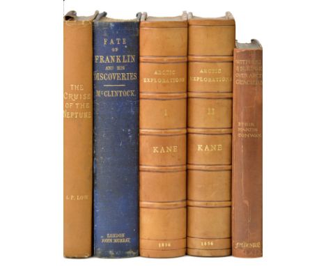
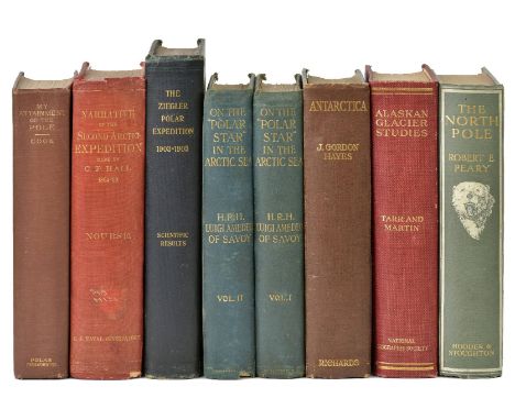
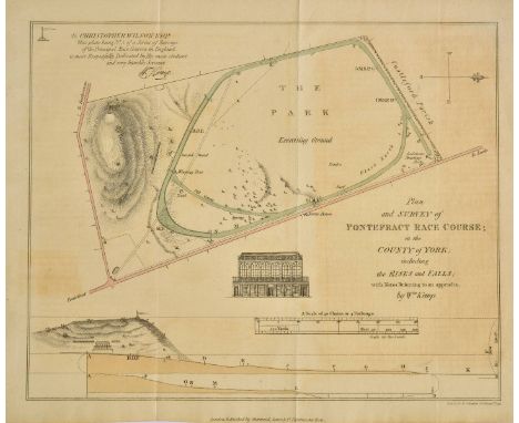
Cook (Frederick A.). My Attainment of the Pole, being the Record of the Expedition that first reached the Boreal Center, 1907-1909, 1st edition, New York: Polar Publishing Co., 1911, 32 photographic plates including frontispiece, contemporary gift inscription to front free endpaper, bookplate removed from front pastedown, original pictorial cloth, slightly rubbed and marked, 4to, together with: Nourse (J. E.), Narrative of the Second Arctic Expedition made by Charles F. Hall, 1st edition, Washington DC: Government Printing Office, 1879, photogravure and heliotype plates, folding colour maps, numerous wood-engravings in the text, linen-backed folding colour map in end-pocket, light tonign to text-block, frontispiece offset, Olivet College library plate, manuscript shelf-mark to title page, front inner hinge repaired, original red pictorial cloth gilt, manuscript shelf-mark to spine, fraying to spine ends, slightly rubbed, sunned and marked overall, 4to; Peary (Robert E.), The North Pole, with an introduction by Theodore Roosevelt, 1st UK edition, Hodder and Stoughton, 1910, 4 photogravure plates including frontispiece, numerous half-tone plates, endpapers spotted, ink-stamp of C. W. M. Swithinbank to front free endpaper, original blue-green pictorial cloth gilt, extremities slightly rubbed and bumped but a bright copy, 4to; Tarr (Ralph Stockman, & Lawrence Martin), Alaskan Glacier Studies of the National Geographic Society in the Yakutat Bay, Prince William Sound and Lower Cooper River Regions, 1st edition, Washington DC: National Geographic Society, 1914, photographic frontispiece, text illustrations, 9 folding maps in end-pocket, light spotting to prelims, ownership ink-stamp to front free endpaper, original red cloth lettered in gilt, corners bumped, pale mottling to rear cover, 4to; Hayes (J. Gordon), Antarctica, a Treatise on the Southern Continent, 1st edition, 16 plates, 14 charts of which 4 folding in end-pocket, browning to endpapers, top edge gilt, original blue cloth, sunned and rubbed, 4to; Abruzzi (Luigi Amedeo of Savoy, Duke of the), On the "Polar Star" in the Arctic Sea, translated by William Le Queux, 2 volumes, 1st edition in English, Hutchinson & Co., 1903, 16 photogravure plates, 2 folding panoramas, 6 colour maps of which 2 folding in end-pocket, light spotting and thumbing to plates, inner hinges cracked, original blue-green pictorial cloth gilt, rubbed, small chip to foot of volume 2 spine, 4to; Peters (William J.), The Ziegler Polar Expedition 1903-1905. Scientific Results ... edited by John A. Fleming, 1st edition, Washington DC: National Geographic Society, 1906, 2 colour maps, 13 tables and charts, 19 coloured lithographic plates of the aurora borealis, 3 further plates, lacking the 3 folding maps in the end pocket, original green cloth, rubbed and mottled, 4to Arctic Bibliography 3389 (Cook), 6486 (Nourse), 13230 (Peary), 17452 (Tarr), 10423 (Abruzzi), N/A. (7)


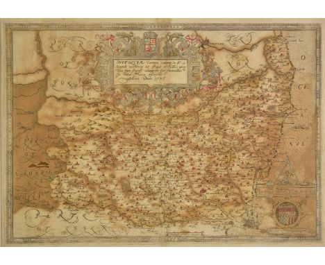
![*Philippines & Indonesia. Sanson (Nicolas), les Isles Philippines [on sheet with] Islas de los Ladrones ou Isle des Larrons,](https://cdn.globalauctionplatform.com/3690c511-8e71-437a-8bbb-a96100bdb491/e99b22ad-0840-4901-a34d-eb5b5a217ca3/468x382.jpg)


![*Roman Empire. Speed (John), A new mappe of the Romane Empire newly described..., Thomas Bassett & Richard Chiswell, [1676],](https://cdn.globalauctionplatform.com/3690c511-8e71-437a-8bbb-a96100bdb491/cdf5ea27-c41d-4acd-ca56-4eab5815bc93/468x382.jpg)


![*Surrey. Speed (John), Surrey described and divided into hundreds, Thomas Bassett & Richard Chiswell, [1676], hand coloured e](https://cdn.globalauctionplatform.com/3690c511-8e71-437a-8bbb-a96100bdb491/ba9b057e-1bec-4238-d63c-e8c34bdb5964/468x382.jpg)


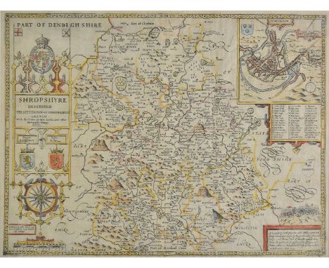
![Wales. Lhuyd (Humphrey, Ortelius Abraham), Cambriae typus auctore Humfredo Lhuydo Denbigiense Cambrobritano, [1592 or later],](https://cdn.globalauctionplatform.com/3690c511-8e71-437a-8bbb-a96100bdb491/f59bba3d-a27a-4fc3-b755-3cc17e4e3476/468x382.jpg)

![*Worcestershire. Speed (John), Worcestershire described, Thomas Bassett & Richard Chiswell, [1676], hand coloured engraved ma](https://cdn.globalauctionplatform.com/3690c511-8e71-437a-8bbb-a96100bdb491/b91b0103-fdf5-4dc6-e9b4-d17708a0ceb2/468x382.jpg)
![Worcestershire. Speed (John), Worcester described, Thomas Bassett & Richard Chiswell, [1676], hand coloured engraved map, ins](https://cdn.globalauctionplatform.com/3690c511-8e71-437a-8bbb-a96100bdb491/1d78e643-e9ee-43cb-86de-1bf7e45a1d0a/468x382.jpg)