We found 109198 price guide item(s) matching your search
There are 109198 lots that match your search criteria. Subscribe now to get instant access to the full price guide service.
Click here to subscribe- List
- Grid
-
109198 item(s)/page


Lot 108
An early 20thC autograph book dated 1929 of an Ernest A Burn, to include Lancashire & England cricketers Eddie Paynter, Cecil Parkin, Johnny Tyldesley, Indian & the West Indies players, Lancashire second team, and the conductor Syd Seymour, and a quantity of autographs to include Stockport Secondary School staff, various drawings, printed works, W Whites autograph, The 1932 Stockport Secondary School Lacrosse team autographs, various other autographs etc, black and white map of Norfolk book plate and an indenture date 7th July 1883. (3)


Lot 123
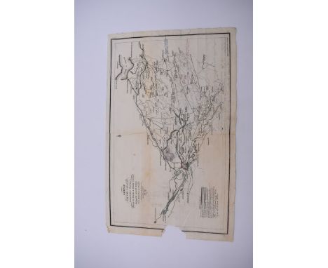
CANAL MAP, POSTED, 1830: 'Sketch of the Canals Lanarkshire Railways Firth of Forth & River Clyde shewing the intended railway from the harbour of Glasgow to connect the same...' engraved by Kirkwood & Son, Edinburgh, 1829: copper engraved map utilised as letter entire, approx 24.5 x 38cm, some hand-colouring and few manuscript amendments, folded and postally used, addressed to 'His Grace The Duke of Hamilton at Hotel d'Alberg, Paris, Feb 12th 1830', short note in ink from sender J. Montgomery Cunningham, Geneva, wax seal, one edge torn with portion of loss, some browning. (1)

Lot 125
LONDON & NORTH WESTERN AND GREAT WESTERN JOINT RAILWAYS: 'Diagrams of private sidings: Birkenhead, Wrexham and Minera , and Vale of Towy lines...': Euston, January 1917: oblong folio, morocco backed boards with spine deficient, approx 36 full page track plans, several folding: with another folded railway map, 'LM & SR England & Wales Estate Districts'. (2)
Lot 191
SUSSEX TOPOGRAPHY: SITWELL (Osbert): 'Brighton', London, Faber, 1938: 3rd edition: 8vo, dustjacket a little chipped to edges else VG: with approx 50 other vols, Sussex topography, generally in very good condition, plus '250 Years of Map Making in the County of Sussex 1575-1825', introduction by R A Skelton, large folio. (Quantity)
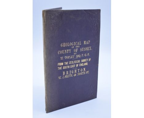
Lot 197
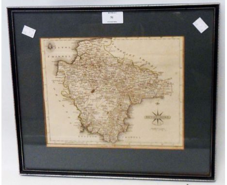
GEOLOGY OF SUSSEX: TOPLEY (W, Esq): 'Geological Map of the County of Sussex...from the geological survey of the south east of England': Brighton, n.d (circa 1860?), W. J. Smith, 43 North Street: folding steel engraved map printed in colours, publishers blindstamped plum cloth boards gilt lettered to upper, sunning and light wear to spine, a few minor tears else VG. (1)

Lot 55
MAPS: collection of 11 miscellaneous maps, 17th-19th century, to include hand-coloured map of Cumberland by Robert Morden: 'Hydrographical Chart of The World on Wright or Mercator's Projection with tracts of the last circumnavigators', large double-page copper engraved map with contemp hand-colouring, early c19, long closed tear lower left: 'The Road from Bristol to Weymouth' by Bowen & Owen, circa 1720, uncoloured in modern window mount, and others. (11)
Lot 73
ROBERTS (Captain George): 'The Four Year's Voyages of Capt. George Roberts; being a series of uncommon events, which befell him in a voyage to the islands of the Canaries, Cape Verde, and Barbadoes, from whence he was bound to the coast of Guiney...': First Edition, 1726, 4 engraved plates and folding map, light browning and foxing throughout, contemp calf gilt, worn and scuffed with front boards detached. (1)

Lot 171
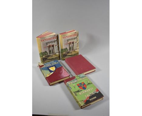
Three Books by Field-Marshal the Viscount Montgomery of Alamein to Include A 1961 First Edition of The Path to Leadership Published by Collins, London, 1948 Edition of Normandy to the Baltic (Complete with Map) and El Alamein to The River Sangro Together with Two Volumes of Sandhurst by Brigadier Sir John Smyth with a Foreword by Field-Marshal the Viscount Montgomery of Alamein


Lot 114
Giovanni Brun Copper engraving of the famous plan of Rome engraved in 1551 by Leonardo Bufalini, reduced by Giovan Battista Nolli in 1748. , Recorded by Giovanni Brun(1754–1800), engraver active in Rome in the second half of the 18th century, the map full margins, some surface dirt and minor browning, unframed, rolled, and water damage, 44 cms x 67 cms together with another engraved plan of Rome with key, , unframed, rolled, 1798, similar water damage, full margin 42 cm x 65 cm (2)Condition ReportPlease see additional images44 cm x 67 cm and 42 cm x 65 cm are the measurements of the plate line84 cm x 56cm approx. are the measurements of the sheet


Lot 30
Fortescue Duguid, Col A "The Official History of the Canadian Forces in the Great War 1914-1919, General Series Vol 1, August 1914 to September 1915", publ by the Authority of the Minister of National Defence, Ottawa 1938, ep map, folding maps, red cloth with armorial crest to front board and gilt titles Birchall, Captain A P "Royal Fusiliers 'Rapid Training of a Company for War", Gale & Polden Ltd 1914, limp covers, 3 copies (4)

Lot 62
Monty Python Interest:Jones, Terry"The Lady and the Squire", ills Michael Foreman, Pavilion Books 2000, inscribed and signed on the tp 'to Olivia from Terry Jones', ills, map on ep, red cloth, dj not price clippedIdle, Eric"Always Look on the Bright Side of Life", Weidenfeld & Nicolson 2018, bearing signature 'Eric Idle' on tp, orange cloth, yellow ep, dj not price clipped Palin, Michael"Erebus, the Story of a Ship", Hutchinson 2018, pictorial ep, orange cloth, dj not price clippedJones, Terry"The Saga of Eric the Viking", ills Michael Foreman, Pavillion Books, Michael Joseph 1983, pictorial ep, brown cloth, dj not price clipped "Fairy Tales", ills Michael Foreman, Pavilion Books, Michael Joseph 1987, pictorial ep, blue cloth, dj not price clipped Gilliam, Terry"Animations of Mortality", Eyre Methuen 1978, numerous photographic and other ills, shocking pink cloth, dj not price clipped (6)
Lot 8
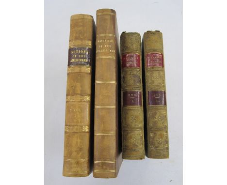
Huc, M "L'Empire Chinois ... Souvenirs d'un Voyage dans la Tartarie et le Thibet", 4th edition, Paris, Gaume Freres et J Duprey 1862, 2 vols, folding map to vol 1, staining to vol 2 on tp and further into text, marbled boards, marbled ep, half green morocco, pastedown titles and raised bands, backstrips and leather all rather worn Snodgrass, Major "Narrative of the Burmese War detailing the operations of Major General Sir Archibald Campbell's Army ... February 1826", John Murray 1827, frontis, folding map, marbled boards, half brown morocco, gilt titles, backstrip faded and corners bumped"Notions of the Americans - Picked up by a Travelling Bachelor", vol 1 only, Henry Colburn 1828, marbled boards, half leather, pastedown title and raised bands, rubbed (4)


Lot 591
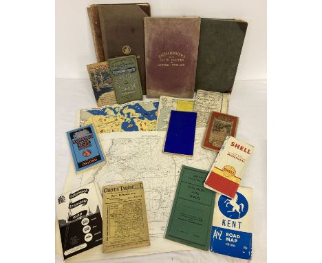
EPHEMERA, a collection of legal documents (indenture, will, settlements, death certificate, etc), seven Peat's Farmer's Diary Account books, twenty two mid 20th century publications (The Footprint, Rose Hill Footprints, Norvic Way) Old and Young 'The Variety Journal' 1893, a ration book 1953 - 1954, five mid 20th century photographs of Leek, an album of 100 photographs of Scotland and a RAC Quick-Way Motoring Map of London published by George Philips and Sons E.C.4 (cloth edition)

Lot 428
Laurie, Robert and Whittle, James - A New and Elegant General Atlas, 7th edition, folio, half calf, with engraved frontis, dedication page (to the Princess of Wales) - 1cm. tear to lower margin, coloured engraved elementary map and 37 other numbered hand-coloured maps, including two double page, loss to upper right margin of map of South America, front board hinge weak, London, 1810

Lot 433
Nightingale, Joseph - English Topography: or, a Series of Historical and Statistical Descriptions of several Counties of England and Wales, qto, original 1/8 leather binding with marbled boards, with contemporary hand-coloured frontis map, waterways map and 56 county and regional maps, Baldwin, Cradock and Joy, London, 1816

Lot 596
Miscellaneous memorabilia, including a 'Miss Columbia' aluminium ashtray made from the fuel tank of the Wright-Bellanca W.B. 2 'Columbia', the first aircraft to fly the Atlantic twice, the top with the aircraft and a map of the North Atlantic in relief, the underside with inscription, together with an enamelled crown and flag badge and a small collection of Coronation souvenirs mounted on velvet and boxed, comprising an Edward VIII badge and spoon and two George VI and Elizabeth medals with ribbons, ashtray length 16.5cm


Lot 11
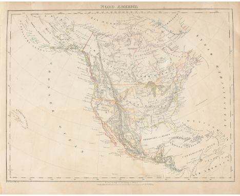
A REPUBLIC OF TEXAS MAP, "Nord America," CARL FLEMMING, GLOGAU, CIRCA 1844, hand-colored lithograph on paper, Carl Flemming cartographer. 14" x 17 1/4" Note: Showing Houston and Galveston Bay in the Gulf of Mexico. Condition: Some expected wear at paper edges, toning, minor losses some fading of hand color, stains, but overall in good condition, wear commensurate with age. Simpson Galleries strongly encourages in-person inspection of items by the bidder. Statements by Simpson Galleries regarding the condition of objects are for guidance only and should not be relied upon as statements of fact and do not constitute a representation, warranty, or assumption of liability by Simpson Galleries. All lots offered are sold "AS IS." NO REFUNDS will be issued based on condition.

Lot 193
ROBERT DELFORD BROWN (American 1930-2009) A PAINTING, "Another Map to Nevada," glitter glue and acrylic on canvas board, signed at right in red glitter glue. 11 1/2" x 15 1/2" Provenance: Estate of David E. Brauer, Houston, Texas. Condition: Some minor toning and yellowing, some dust debris, and small stains in upper right corner, but overall in fair to good condition, wear commensurate with age. Simpson Galleries strongly encourages in-person inspection of items by the bidder. Statements by Simpson Galleries regarding the condition of objects are for guidance only and should not be relied upon as statements of fact and do not constitute a representation, warranty, or assumption of liability by Simpson Galleries. All lots offered are sold "AS IS." NO REFUNDS will be issued based on condition.

Lot 197
ROBERT DELFORD BROWN (American/Texas 1930-2009) A MIXED MEDIA COLLAGE, "Another Map to Nevada, San Antonio," 1994, mixed media collage on paper, mounted to board, signed and dated along right edge. 18 1/2" x 24 1/2" Provenance: Exhibited in "AN ART HISTORIAN COLLECTS: The David E. Brauer Collection" at the Mobile Museum of Art, Mobile, Alabama February 7 - November 29, 2020. Estate of David E. Brauer, Houston, Texas. Condition: Framed in acrylic display frame, generally in good condition. Simpson Galleries strongly encourages in-person inspection of items by the bidder. Statements by Simpson Galleries regarding the condition of objects are for guidance only and should not be relied upon as statements of fact and do not constitute a representation, warranty, or assumption of liability by Simpson Galleries. All lots offered are sold "AS IS." NO REFUNDS will be issued based on condition.
Lot 466
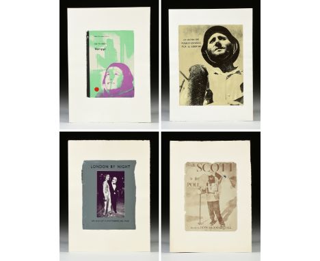
R.B. KITAJ (American 1932-2007) SIX PRINTS, FROM THE SERIES "In Our Time: Covers for a Small Library After the Life for the Most Part," 1969-70, comprising six screenprints on paper from a portfolio of fifty, all signed in margin in pencil L/R, "RK." "(7)Der Russische Revolutionsfilm." 15" x 10"; "(28) Wir haben es nicht vergessen-Nous n'avons pas oublie- We Have Not Forgotten." 12 1/4" x 18"; "(34) Vampyr." 18" x 13"; "(35) La Lucha del Pueblo Español por su Libertad." initialed in pencil in margin L/R "RK," 22" x 17 1/2"; "(36) With Scott to the Pole," numbered in margin in pencil L/L 146/150. 19 1/4" x 14 1/2"; "(50), London by Night - Life and Art in Photograph; no. four." 19 1/4" x 15" Note: In Our Time: Covers for a Small Library After the Life for the Most Part, Kitaj’s finest and strangest print projects, and consists of... 50 screenprints...each of which replicates the cover of a single book from the artist’s own library and marked a significant departure from the visual complexity of his earlier work. It was made by [Chris Prater of Kelpra Studios] Prater in London on the basis of detailed instructions sent to him by Kitaj...He produced few paintings during this period, dedicating his energies chiefly to this large-scale project. While each book stands alone in each print, together they map the artist’s pursuit of cultural and artistic identity through literature, poetry, history, Jewish subjects, politics, film, and the human form. Kitaj in our Time: Prints and Obsessions Reference: Catherine Daunt, from Volume 3, Number 4 Provenance: Estate of David E. Brauer, Houston, Texas. Condition: All generally in very good to excellent condition. All have printed stamp verso with "K" along with an identification number. "(36) With Scott to the Pole" is the only print to be numbered in margin in pencil L/L 146/150. Simpson Galleries strongly encourages in-person inspection of items by the bidder. Statements by Simpson Galleries regarding the condition of objects are for guidance only and should not be relied upon as statements of fact and do not constitute a representation, warranty, or assumption of liability by Simpson Galleries. All lots offered are sold "AS IS." NO REFUNDS will be issued based on condition.
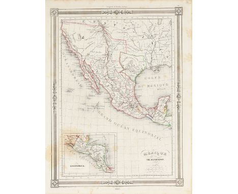
Lot 59
A REPUBLIC OF TEXAS MAP, "Méxique," THUNOT DUVOTENAY, PARIS, CIRCA 1843, hand-colored lithograph on paper, Thunot Duvotenay, French cartographer, Charles Smith, English plate engraver, a page fragment from a larger atlas by Maison Basset, publisher, with inset map of Guatemala (showing Honduras, Nicaragua, Costa Rica, and Belize), within a neoclassical border with Tudor roses, plate 31, and dated in margin, sheet: 13 1/4" x 10 1/8". Condition: Some stains and spots throughout, toning and yellowing, but overall in good condition, wear commensurate with age. Simpson Galleries strongly encourages in-person inspection of items by the bidder. Statements by Simpson Galleries regarding the condition of objects are for guidance only and should not be relied upon as statements of fact and do not constitute a representation, warranty, or assumption of liability by Simpson Galleries. All lots offered are sold "AS IS." NO REFUNDS will be issued based on condition.


Lot 259
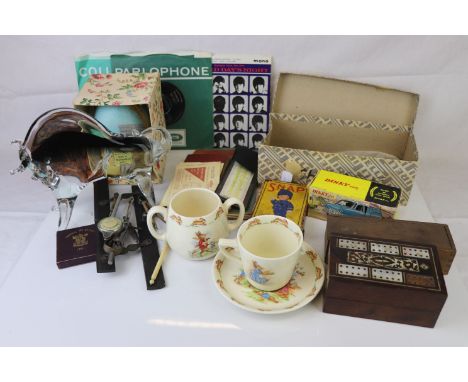
Large quantity of mixed collectables to include a selection of Wade Whimsies, Folded Map, Ration Books,a boxed Dinky Ford Transit van, no. 407, Drawing Equipment, Dominoes and Cribbage, Playing Cards, Royal Doulton Bunnykins items, Postcards, Murano Glass Bull, selection of Beatles records, etc
-
109198 item(s)/page