We found 109182 price guide item(s) matching your search
There are 109182 lots that match your search criteria. Subscribe now to get instant access to the full price guide service.
Click here to subscribe- List
- Grid
-
109182 item(s)/page


Lot 51
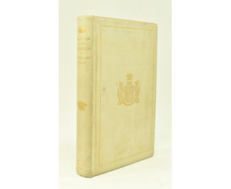
1900 A Calendar of the Charters, Rolls and other Documents (dating from A.D. 1182), as contained in the Muniment Room at Sherborne House, in Gloucestershire, belonging to the Right Honourable The Lord Sherborne Baron of Sherborne. Privately printed 1900. Folding map frontispiece. Publisher's orig. full cloth binding with gilt titles and coat of arms to front board (light edgewear), pages uncut, otherwise a smart copy. 8vo.
Lot 2
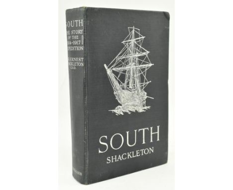
Polar interest. Shackleton, Ernest Henry. 1919 South: The Story of Shackleton's Last Expedition 1914-1918: by Sir Ernest Shackleton C.V.O. Publ. London: William Heinemann. First edition, first issue. Complete with errata slip opp. page 1, folding map to rear, colour frontispiece, panorama of Georgia to pages 208-209, collated and complete with all black & white illustrations. Publisher's original full cloth binding, silver titles & ship to front board as issued, bumped to the head & tail of the spine, bumped to corners particularly the upper right hand corner of the front board. Odd waterstain & paint stain to rear board. Gift inscription from 1919 to ffep & a later 1964 one also to ffep. Binding generally tight, pages a little age-toned to the edges, plates also age-toned. 8vo.

Lot 97
Beaglehole, J. C. (ed.). 1955 The Journals of Captain James Cook on his Voyages of Discovery: The Voyage of the Endeavour 1768-1771. Published Cambridge for the Hakluyt Society at the University Press. Publisher's original full cloth binding (in need of a clean), with unclipped dust wrapper lightly sunned to spine and with occasional nicks to the edges. Illustrated with folding map illustrations. 8vo.

Lot 79
Barrett, William. 1789 The History and Antiquities of the City of Bristol; compiled from Original Records and authentic Manuscripts, in public Offices or private Hands; illustrated with Copper-plate Prints. By William Barrett, Surgeon F.S.A. Printed by William Pine. Illustrated with folding map frontispiece and other folding plates throughout the text. Contemporary calf boards & gilt tooled spine, rebacked with recent cloth with reinforced hinges. Frontispiece portrait, folding map and title page all loose but present. Illustrated with folding engravings. 4to.
Lot 10
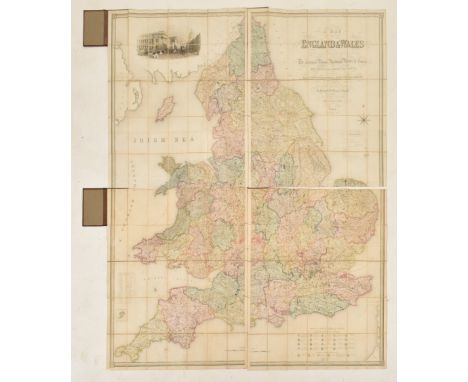
1840 A Map of England and Wales divided into Counties, Parliamentary Divisions and Dioceses, shewing the Principal Roads, Railways, Rivers and Canals, and the seats of the nobility and gentry with the distance of each town from the General Post Office, London. Drawn by R. Creighton, engraved by J. Dower, published by S. Lewis & Co. 1840. Four maps backed on folding linen, hand coloured, each in 35 sections presenting a quarter of the entire map. Each map housed in case bound in smart straight grain morocco, gilt titles to spine and decorative tooling to front boards, odd light bump to extremities or mark to the boards, leather occasionally lightly chipped to the spine, light bumping to the head & tails and odd scratch. 8vo when folded in case, each map measuring approx. 106cm x 90cm.

Lot 87
1826 Paterson's Roads; being an Entirely Original and Accurate Description of all the Direct and Principal Cross Roads in England and Wales, with Part of the Roads of Scotland. The Eighteenth Edition. by Edward Mogg. Printed for Longman, Rees, Orme, Brown and Green, 1826, illustrated with folding map frontispiece, one folding map in the text and seven bound to rear. Original worn full calf binding, both boards near loose & having been taped to the gutter, spine rebacked with cloth. Pages a little age-toned. 8vo.
![Military First World War interest. [1931] A Record of the D 245 Battery 1914-1919. by Sergeant A. E. Gee, M.M. and Corporal A](https://cdn.globalauctionplatform.com/d7523d17-a864-40cc-8966-b12c0110a60f/0f9e146f-4a1b-4c3c-8897-b13800fb2897/468x382.jpg)
Lot 126
Military First World War interest. [1931] A Record of the D 245 Battery 1914-1919. by Sergeant A. E. Gee, M.M. and Corporal A. E. Shaw. Illustrations by Bombardier Norman Tennant. Publ. Renwick of Otley. Publisher's orig. full mottled cloth binding, odd mark, prior owner's inscription dated 1931 to front pastedown, folding map loose to verso. 8vo.
Lot 76
1772 The History and Antiquities of Rochester and its Environs: To which is added, a Description of the Towns, Villages, Gentlemen's Seats, and Ancient Buildings, situated on, or near the Road from London to Margate, Deal, and Dover. Embellished with Copper-Plates. Printed and sold by T. Fisher, sold also by S. Crowder, booksellers, in Paternoster Row, London 1772. Illustrated with folding map frontispiece engraving, and other plates through the text. Full contemp. calf binding with orig. gilt titles & spine label, loss to the tail of the spine and wear to the hinges, calf rather rubbed and extremities bumped resulting in slight loss. An interesting study into the history of Rochester, Kent. 8vo.
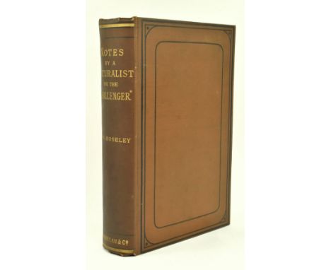
Lot 108
Moseley, H. N. 1879 Notes by a Naturalist on the Challenger, being an Account of Various Observations made during the Voyage of H. M. S. Challenger Round the World, in the years 1872-1876, under the commands of Capt. Sir. G. S. Nares and Capt. F. T. Thomson. First edition, publ. Macmillan and Co. 1879. Illustrated with a map, two coloured plates and numerous woodcuts. Publisher's original full cloth binding with just light edgewear and the odd light mark to the boards, small ownership bookplate of E. B. Kemp Welch to front pastedown, pages a touch spotted on occasion. 8vo.
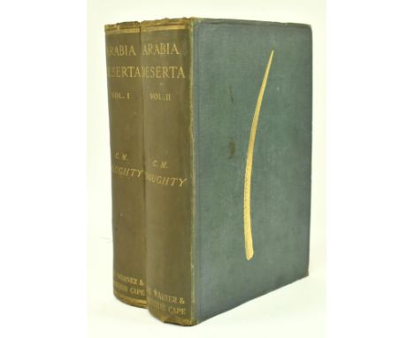
Lot 55
Travel & Exploration. 1921 Travels in Arabia Deserta by Charles M. Doughty, with a new preface by the author and all original maps, plans and cuts. Two volumes, publ. Philip Lee Warner, 1921 trade issue. Publisher's original full cloth binding, light bumping to the head and tail of the spine, gilt pictorial boards, folding map to verso. 8vo.

Lot 34
Cartography interest. 1841 Bradshaw's Railway Companion, containing the Times of Departure, Fares, &c. of the Railways in England, and also Hackney Coach Fares from the Principal Railway Stations. Illustrated with maps of the country through which the railways pass, and plans of London, Birmingham, Leeds, Liverpool and Manchester. Publ. Bradshaw & Blacklock. Original full cloth binding with gilt label to front board, damage to rear board & leaves preceding, otherwise smart, contemp. prior owner's inscription in pencil to title page, forty-nine leaves of timetable information, loose folding map of railways in England and Wales, folding map of principal lines and fourteen pages of maps, with four double-page city plans. Measures approx. 12cm x 8cm.


Lot 442
Antiquarian. Religious History. Sewel, William - The History of the Rise, Increase, and Progress of the Christian People called Quakers. London: James Phillips and Son, 1799-1800. Fourth edition. Two volumes. Contemporary calf, boards detached, spines perished. With; A Map to Accompany The Friends' Book of Meetings. London: Edward Hicks, Jnr., 1894. In slipcase. (3)

Lot 406
Wainwright. Wainwright in Lakeland. Kendal: The Governors of Abbot Hall Art Gallery, 1983. Limited edition of 1,000 copies, this being number 285. Signed by Wainwright. Map in pocket at rear. Original green rexine binding, in the dust jacket. A nice bright copy. Slight lean on spine. With card mailing box. (1) Condition: Clean and bright, binding square and tight. A 'Fine' copy.

Lot 506
Local History. Antiquarian. Hutchinson, W. - The History and Antiquities of Cumberland. Carlisle: F. Jollie, 1794. In two volumes. Collated, correct as per plate list. With a total of 60 plates/plans + County folding map (volume II has an additional portrait plate at p.229 and 5 other additional eng. plates). Full calf, gilt ruled. With; a Lyson's Cumberland. London: 1816. With plates, plans and map. Contemporary half calf, marbled boards, spine in gilt. (3)


Lot 529
Signed Copy. Wainwright, A. - Wainwright in Lakeland. Kendal: 1983. Signed by Wainwright in green to head of end paper. In the dust jacket. With map in pocket at rear. (1) Notes: Title page dated 1983. The dust jacket is somehwat discoloured/dust-soiled. Spotting to the text-block. Map is browned/foxed. Binding square and tight.

Lot 526
Maps. Three folding linen-backed maps. The 'District Railway' Map of London (6th edition).; A New Map of the Country Round Manchester. London: John Stockdale, 1794.; Map of England & Wales Divided into Counties shewing the Principal Roads, Railways, Canals & the Rivers as far as they are Navigable. London: R. Creighton for Lewis's Topographical Dictionary. (3)

Lot 438
Maps. Lake District. Three folding maps: Otley, J. - A Correct Map of the Lake District; with the Height of the Principal Hills, Their Bearings and Distances; the Stages, and Interesting Excursions. Keswick: 1841. Original textured cloth covers; Walker, J. & C. - Westmorland. London: 1841. Loose in original covers. With; an 1863 Ordnance Survey map of Westmorland. (3)
Lot 437
Antiquarian. Lake District Guides. West, Thomas - A Guide to the Lakes in Cumberland, Westmorland, and Lancashire. Kendal: Printed by W. Pennington, 1812. Tenth edition. Map frontispiece. Contemporary leather, worn. With; Atkinson's Hand-Book to the English Lakes. Kendal: 1852. Seventh edition. Map to end paper (damaged). Adverts section at rear with loss. (2)

Lot 485
Travel. Maw, Henry Lister - Journal of a Passage from the Pacific to the Atlantic, Crossing the Andes in the Northern Provinces of Peru, and Descending the River Maranon, or Amazon. London: John Murray. 1829. With folding map. Contemporary straight-grained morocco, wear and rubbing to extremities, recently re-backed to match with earlier backstrip laid-on. Retains end papers with heraldic bookplates. (1)

Lot 439
Antiquarian. Local History. Nicolson, Joseph & Burn, Richard - The History and Antiquities of the Counties of Westmorland and Cumberland. London: W. Strahan; and T. Cadell. 1777. Two volumes, each with folding map. Volume I bound in a half leather, marbled boards. Volume II bound in a full cloth. With; Whellan, William - The History and Topography of the Counties of Cumberland and Westmoreland. Pontefract: 1860; and one other. (4)

Lot 432
The History and Antiquities of the Borough of Reading by John Man, 1816, printed by Snare and Man of Minster Street, Reading. Half leather bound, edges not cut, 21 plates and plans including a copy of Speed's map of 1610 and a map of the Borough dated 1813 (bottom of map detached). Estimate £30-60


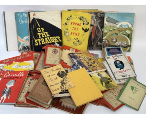
Lot 121
A large collection of various works comprising, a collection of various Ordnance Survey One-Inch Map of Scotland Inverness and Fort Augustus etc and a group of Russell Brockbank books- Up the Straight, The Brockbank Omnibus and The Grand Prix etc and various other books eg - The Hunting of the Snark by Lewis Carroll and A Dictionary of R.A.F Slang etc. (alot)

Lot 224
A group of framed map engravings comprising, "New & Correct Map of the Countries of Argyle, Bute and Dumbarton, New Map of the Western Isles of Scotland" published by Alex Hogg, coloured after (22cmx33cm), a European map coloured after (19cmx24cm) and a "Map of the European Settlements in the East Indies" published Thomas Cadell 1783, coloured after. (35cmx35.5cm) (3)


Lot 79
Banksy (British, b. 1974) Group of four Banksy's books and ephemera comprising one Banksy's Bristol HOME SWEET HOME art book, one Banksy Wall and Piece art book, one Dismaland Bemusement Park brochure and one Dismaland Bemusement park map Printed on paper Brochure measure approx. 34cm x 29cm Banksy (British, b.1974 ) is perhaps the most controversial street artist of the modern day. He is famous for his stencilled graffiti works, which appear in public spaces around the world. His use of stencilling developed from a need to complete a work quickly, namely to avoid being caught vandalizing by police. Banksy often uses multi-layered stencils to employ multiple colours, and he frequently incorporates permanent environmental fixtures, such as street signs and architectural elements, into his work. Marked by dark humour, satire, and political commentary, much of his street art has become viral on the Internet. His most notable early work was the result of a trip to Palestine and the West Bank, where he stencilled nine images on the Bethlehem Wall. Despite his stealth presence, Banksy has become a mainstream phenomenon. In 2010 Banksy directed Exit Through the Gift Shop, a chronicle of the underground world of street art, which was nominated for Best Documentary at the Oscars. In 2015, he opened Dismaland Bemusement Park, a temporary exhibition of an inverted, dystopian Disneyland. Although Banksy has continuously emphasized an aversion to the art world through his output, he also produces traditional works on canvas and prints as well as branded merchandise such as t-shirts. His cultural significance, widespread popularity, and, certainly, the mystery of his identity have all contributed to the desirability of his art. According to Sotheby’s Mei Moses, the average compound annual return for Banksy is 8.5%, with 76.5% of works increasing in value. This lot is sold subject to Artists Resale Rights, details of which can be found in our Terms and Conditions.
Lot 389
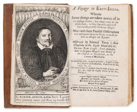
India.- Terry (Edward) A Voyage to East-India, first edition, engraved portrait frontispiece, folding map and 3 plates, M3 headline and pagination trimmed, a few early ink annotations, contemporary sheep, slightly scuffed, [Wing T782], 8vo, Printed by T.W. for J. Martin, and J. Allestrye, 1655.*** An excellent copy. Terry spent three years in India as chaplain to Sir Thomas Roe, ambassador to the Mughal emperor Jahangir.
Lot 306
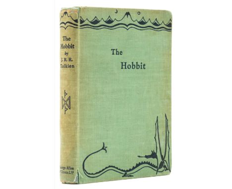
Tolkien (J.R.R.) The Hobbit, first edition, second impression, map endpapers, illustrations, frontispiece and 3 colour plates, very light toning to endpapers and very faint spotting on half-title and occasionally throughout, original cloth, slight shelf-lean, spine ends neatly repaired, extremities a little rubbed and frayed, light surface toning and marking, still overall an excellent copy, [Hammond A3a], 8vo, 1937 [but 1938]. *** See previous lot for publication details.
Lot 305
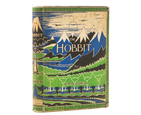
Tolkien (J.R.R.) The Hobbit, first edition, second impression, map endpapers, illustrations, frontispiece and 3 colour plates, small ownership inscription on front free endpapers, original cloth, boards lightly bowed, small strip of fading to extremities, otherwise excellent, dust-jacket, some chips and nicks to extremities, light patch of spotting to upper panel, light spotting to flaps and fore-edge, [Hammond A3a], 8vo, 1937 [but 1938]. *** Rare in jacket.The second impression was the first version of the book to be illustrated in colour: the first impression had two plates only, both of which were uncoloured. A total of 2,300 copies were printed, and some 400 held at the binder's London warehouse were destroyed during the Blitz in November 1940.
![Bible, English. [The holie Bible], [Bishops' Version], black letter, double column, woodcut illustrations, maps and initials,](https://cdn.globalauctionplatform.com/bdf27cdf-4b22-4e00-b3ad-b12c00e4aecd/82a0d53f-9ff6-47a7-bf84-b12c00f2cc9a/468x382.jpg)
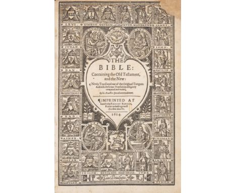
Lot 37
Bible, English. [The holie Bible], [Bishops' Version], black letter, double column, woodcut illustrations, maps and initials, lacks 4 leaves of preliminaries (general title, (ii), *1 and blank f. *8), also P1 (divisional title to part 2), 3A1 (divisional title to part 3), 3P7, 4N10 and from New Testament R1 (leaf of woodcuts relating to Revelation), lacking engraved map of Canaan, general title and (ii) supplied in facsimile, prelims with tears and repairs with loss of some text, some leaves of NT seemingly supplied from another copy, including NT title (incongruous worming within text), ruled border to head trimmed a few times and printed side-note to C5v cropped, a few very small chips or closed tears without text loss, circular ink stain to NT title, NT some ff. with chips or tears repaired, affecting text but generally without loss, NT some worming within text, usually a few small and minor wormholes but heavier to R2, R7 & S1, final 5ff. more extensive repairs with some loss of text, final colophon f. trimmed and laid down with small loss, a few ink marks or inscriptions, some water-staining to preliminaries and final few ff., browned, some soiling and staining, modern antique-style panelled calf, red morocco spine label, few scratches to lower cover, [Herbert 132], folio (c.390 x 250mm.), Richarde Jugge, 1572; sold not subject to return. *** The second folio edition of the Bishops' Bible, this copy far more complete than most. The main body of text containing the Old Testament, Pslames and Apocrypha is in particularly good condition and generally wide-margined. "A remarkable feature of this edition is its two-version Psalter, which exhibits, printed side by side, (1) The translation used in common prayer (taken originally from the Great Bible, and still retained in the Prayer Book) in black-letter, and (2) The translation after the Hebrewes (i.e. the Bishops' version) in roman type" (Herbert). In this copy, the preliminary leaves are bound with Sig.[par] before Sig.* but with leaf [par]10 at end ("order of the preliminary leaves is somewhat uncertain" - Herbert). A grand 16th-century black letter printing on strong paper, one of the most beautiful printings of the English bible.Provenance: William Austin: 1695 ?Born; Obadiah Woodcock January 6. 1766; Kenrick Edisbury (ownership inscriptions to *7).

Lot 411
Voyages.- Thornton (John) A New Mapp of Magellan Straights Discovered by Capp: John Narbrough, with inset map of Patagonia and Tierra del Fuego, decorated with English royal coat of arms of Charles II, a European soldier, Native Americans, ships, and various local animals, engraving with hand-colouring, on sturdy laid paper with Strasbourg lily watermark, platemark 425 x 530 mm (16 3/4 x 20 3/4 in), sheet 490 x 595 mm (19 1/4 x 23 1/3 in), some spotting and surface dirt, two mirrored small nicks/abrasions within centre along the fold, minor marginal nicks with 1-2 cm split in the upper part of the central fold, unframed, [circa 1700]*** Based on the map from John Narborough's book, the first Englishman to sail through the Strait of Magellan in both directions.
Lot 320
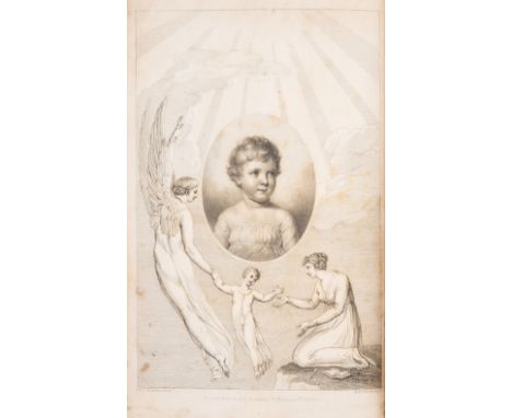
Blake (William).- Malkin (Benjamin Heath) A Father's Memoirs of his Child, first edition, half-title, engraved frontispiece by R.H.Cromek after William Blake and 3 plates, one a folding map, light foxing to plates and occasionally text, short tear to outer margin of p.i/ii, modern half morocco, spine gilt in compartments with five raised bands, uncut, [Bentley 482], 8vo, for Longman, Hurst, Rees and Orme by T. Bentley, 1806.*** Contains the first recorded account of Blake by a contemporary. Malkin knew Blake well, and herein devotes 24pp. in the preface to an account of his friend's life and genius, largely recorded from conversations with Blake himself. The preface also contains the first typographic printing of several of Blake's poems including a variant of 'The Tyger'.
Lot 44
Bible, English. The Bible: Containing the Old Testament, and the New, 2 parts in 1, black letter, double column, general & NT titles within heart-shaped woodcut borders, NT and colophon both dated 1615, general title small chip and paper repair to upper corner, A8 portion at foot torn away and repaired with text supplied in ink manuscript, following f. with loss to fore-edge repaired (some printed side-notes supplied in manuscript), the odd other defect, tear or paper repair, affecting text or with small loss, trimmed at head, occasionally shaving headline, occasional early ink marginalia, lightly browned, some soiling and staining, [STC 2234; Herbert 339], Robert Barker, 1614 [but 1615] bound with a defective Book of Common Prayer and Speed's Genealogies (lacking map of Holy Land) at beginning, and RFH Concordances (1619) and an incomplete Sternhold and Hopkins Whole Book of Psalmes (1619) at end, together 5 works in 1 vol., later blind-stamped calf, rebacked preserving original backstrip, rubbed, 4to; sold not subject to return. *** Provenance: William Colling (contemporary ownership inscriptions to A8v and final leaf of NT); Archdeacon E. J. Nash (ink gift inscription to front free endpaper, dated Christmas 1919); Gilbert Bishop of Carpentaria (bookplate).
Lot 390
India.- Third Anglo-Mysore War.- Smith (James) Plan of the position of the Confederate Armies under the Direction of Earl Cornwallis before Seringapatam, engraving by Armstrong, with some hand-colouring, on cream laid paper without visible watermark, platemark 420 x 320 mm (16 1/2 x 12 1/2 in), 495 x 340 mm (19 1/2 x 13 3/8 in), good margins, some signs of old damp-stains and cracking to sheet, but carefully restored and appears stable, marginal nicks, old folds, unframed, [c. 1793]*** This version of Smith's map, which seems to be unrecorded, was 'Reduced by M. Armstrong', presumably the surveyor and mapmaker Mostyn John Armstrong. Armstrong supplied the map of the Carnatic and Mysore for Home's volume, but this is from a second printing plate, although geographically near identical.
Lot 245
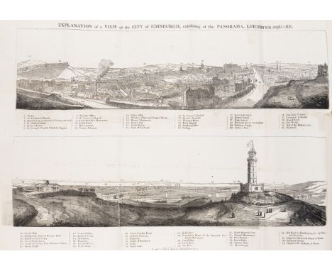
Exhibition pamphlets.- A Collection of 20 Pamphlets, including: 16 panorama exhibition guides, of which 12 with original folding panorama key, 1 with folding plate; and 4 others various exhibitions, travel, and entertainment, 2 of which with a folding plate or map, together 20 in 1, most folding keys or plates creased and browned at folds, and a few with tears or spots, nineteenth century half calf, a little scuffed, 8vo, 1814-1826.*** A broad-ranging collection of pamphlets, recording the popular phenomenon of 'panoramas' in Georgian society. Seeking to provide a truly immersive experience, these vast paintings gave a 'panoramic' view (term first printed 1813), most commonly of foreign climbs - this collection including Athens, Bern, Berlin, Corfu, Edinburgh, Jerusalem, Mexico City, Paris, Pompeii, Spitzbergen and Venice - and also, often during the Napoleonic wars, detailed battle scenes - as here with Algiers and Vittoria. Most of these are exhibited at the Panorama in Leicester Square or the Strand, curated by artists Henry Aston Barker and J. Burford. Other pamphlets cover a painting by Benjamin West, an exhibition of the Imperial State Carriage of Burma, the discovery of an Egyptian tomb, and the phenomenon of the 'living skeleton'.
Lot 203
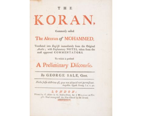
Sales (George) The Koran, Commonly called The Alcoran of Mohammed, first edition, title in red and black, three engraved genealogical tables, folding engraved map of Arabia, and folding engraved plate with plan of Mecca, contemporary calf, rebacked, covers a little scuffed, 4to, C. Ackers for J. Wilcox, 1734.*** First edition of the second and most authoritative English version of the Koran; Sale's translation was the first directly from Arabic to English, and is credited with introducing the West to the Koran. Provenance: Francis Enys of Truro, Cornwall [early engraved bookplate].
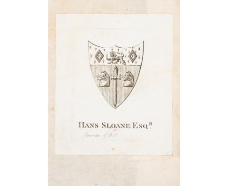
Lot 383
*** Please note, the description of this lot has changed ***America.- Wafer (Lionel) A New Voyage and Description of the Isthmus of America, first edition, folding engraved map and 3 folding plates, advertisement leaf at end, contemporary blind-stamped calf, spine gilt, upper joint slightly cracked, [Wing W193; Sabin 100940], 8vo, Printed for James Knapton, 1699.*** A lovely copy. Bookplate of Hans Sloane probably that of Hans Sloane (1739-1827), the great-nephew of BM founder Sir Hans Sloane. Interesting work on the inhabitants and geography of central America.
Lot 148
Mining.- Zacatecas.- Espejo (Pedro, mining engineer) A la Disputacion de Mineria, manuscript report in Spanish on the San Francisco de la Chica mine and its boundaries, 2pp., map of mine location, stamps affixed, a few short tears, some chipping, lightly browned, Zacatecas, 16 April, 1888 § Grinberg (José, American citizen) Claim for a mine in the Potosí hills of Ojocaliente, manuscript in Spanish, 9pp., stamps affixed, contemporary wrappers with manuscript titles, chipped, Zacatecas, April, 1875; and 4 others, similar, folio (6) *** A good collection of documents relating to the Zacatecas region of Mexico, well known for its rich deposits of silver, and other minerals.

Lot 4222
Large Collection of Vintage travel maps and items - To include Central buses map and route list (1968), other London transport and underground maps. (1 box). Please note this lot has the standard Ewbank's standard buyers premium payable on top of the hammer price and not the reduced rate for cars and motorbikes.

-
109182 item(s)/page