We found 109182 price guide item(s) matching your search
There are 109182 lots that match your search criteria. Subscribe now to get instant access to the full price guide service.
Click here to subscribe- List
- Grid
-
109182 item(s)/page


Lot 276
William Cobbett, 'A Year's Residence in the United States of America', third edition, published by J M Cobbett, London in 1822, with fold out map, and another volume by the same author; 'Cottage Economy', published by Charles Clement in 1824, both in later bindings CONDITION REPORT: Please note - Descriptions do not include condition reports. Please contact us to if you require further information or images.PLEASE CONSIDER SHIPPING COSTS BEFORE BIDDING. THE COST OF SHIPPING MAY AFFECT YOUR DECISION TO BID.

Lot 289
Thomas Kitchin (1718 - 1784)'An accurate map of Carmarthenshire drawn from an actual survey with various improvements'Handcoloured map from Thomas Kitchin and Emanuel Bowen's 'The Large English Atlas', first published in 1762 with many further editions. CONDITION REPORT: Please note - Descriptions do not include condition reports. Please contact us to if you require further information or images.PLEASE CONSIDER SHIPPING COSTS BEFORE BIDDING. THE COST OF SHIPPING MAY AFFECT YOUR DECISION TO BID.


Lot 251
14 framed and glazed pictures and prints and one unframed. To include 'A New Map of Pembrokeshire - Drawn from the best authorities by Thos. Kitchin'; 'Paderborn' ; four original works by Françoise Goin; a mid-19th century watercolour portrait of Elizabeth Gough (1778-1858), signed H.G. Walker? and titled verso 'Elizabeth, dau. of Col. George Gough, wife of Benjamin Frend of Rockdown, Co. Tip.' (sister of Field-Marshal Gough of Goojerat); a 19th century hand-coloured, triple ornithological subject engraving (15)


Lot 153
GROUP OF TWO MEDICAL THANGKAS FROM THE BLUE BERYL SERIES QING DYNASTY, 19TH CENTURY comprising: a thangka depicting a naked human's back with arms spread, pigmented upper and mid body internals, covered allover in symmetrical red grid with various dots at which moxibustion should be applied, reserved on inscriptions taken from the Medical Text 'Gyud Zhi' explaining the reasons; and the other depicting human's energy movement, including a male's body, a flayed body with internals exposed, and a skeleton in ardhaparyank asana position reserved on inscriptions, each figure painted with blood vessels throughout the whole body, and a green line cut through from the top of the head to perineum (Dimensions: 65cm x 45.5cm each) (Qty: 2)(65cm x 45.5cm each)Qty: (2)Footnote: Provenance: Private Manila collection; the present owner's father acquired them in the 1970s Note: The paintings are an extension of the Four Tantras appearing as part of the commentary written by Sangye Gyamtso, Regent to the Fifth Dalai Lama, in 1687-88, and entitled The Blue Beryl. The fundamental text of Tibetan medicine is the Tantra of Secret Instructions on the Eight Branches, the Essence of the Elixir of Immortality and commonly abridged as Four Tantras (Gyud Zhi), teaching four methods of treatment: Diet, Lifestyle, External Therapies, and Medication. The paintings shown here include the anterior and posterior views of vulnerable points from the 'Exegetical Tantra'. In Tibet, moxibustion is the application of heated needles into the skin and deep muscle and is one of the preferred ways to overcome pain; an energy movement chart depicts routes where psychic energy travels throughout the human body and is used as a demonstration article rather than as something which could have been demonstrated by physical examination. It does not claim to be a map of blood vessels although Tibetans knew about these. However as medicine and Buddhism were strongly linked a chart of psychic energy movement was classified as a medical matter too. Comparable examples sold at Christie's New York, 19th September 2002, lot 151


Lot 3158
"Episcopatus Paderbornensis descriptio nova". Originaltitel Altkolorierte Kupferstichkarte des Bistums Paderborn von Johannes Gigas (Ioanne Gigante) bzw. J. Janssonius, Amsterdam, um 1630. Darstellung ca. 38 cm x 48,5 cm. Rahmen.A map of the Bishopric of Paderborn. Hand-coloured copper engraving by J. Gigas and J. Jansasonius published in Amsterdam circa 1630.

Lot 3190
"Die Grafschaft Mark Nro. 282". Originaltitel Flächenkolorierte, detailreiche Kupferstich-Karte, erschienen bei Franz Joh. Jos. von Reilly, Wien 1791-1796. Detaillierte Landkarte der Grafschaft, im Zentrum das Gebiet um Dortmund, Schwerte und Hagen, im Osten bis Soest und Lippstadt, im Süden bis Wipperfurth. Die Grafschaft Mark gehörte seit dem 17. Jh. zu Brandenburg-Preußen. Darstellung ca. 21,5 cm x 27,5 cm. Rahmen.A map of the County of Mark. Hand-coloured copper engraving, published 1791-1796.


Lot 315
Münster, Sebastian. Cosmographiae universalis libri VI. Mit Holzschnitt-Titel, 13 (von 14) Vortextkarten in Holzschnitt, 40 (von 41; 3 auf 4 Bl., 37 doppelblattgroßen) Holzschnitt-Ansichten und zahlreichen Textholzschnitten. Basel, Henricpetri, 1554. 12 Bl., 1162 S., 1 Bl. 31,5 x 21 cm. Blindgeprägter Lederband der Zeit über Holzdeckel (berieben, Bezugsfehlstellen am oberen Rücken, ohne Schließen).2. lateinische Ausgabe. - Burmeister 89. - Ohne Vortextkarte Nr. 14, ohne Blatt Z6 (S. 495-496) zu Eyfalia und ohne Blatt Aa3-4 (S. 501-504), Ansicht Colonia. - Zahlreiche Paginierungsfehler. - Die vierblättrigen Tafeln mit Ansichten von Worms, Heidelberg und Wien. - Erste Blätter und Vortextkarten mit wenigen kleinen Wurmlöchern, letzte 50 Blatt etwas mehr, sonst nur vereinzelte kleine Wurmgänge. Ansicht Wien mit Einriss und Bräunung am Falz des 2. Blattes. Vereinzelt gering fleckig. - Recht gutes und sauberes Exemplar, die Holzschnitte in guten Abdrucken, nur vereinzelt schwach.Second Latin edition. - With woodcut title, 13 (of 14) woodcut maps, 40 (of 41; 3 on 4 leaves, 37 double-page) woodcut views and numerous text-woodcuts. Contemp. blindstamped full calf over wooden boards (rubbed, some loss of leather to upper spine). - Without map no. 14, leaf Z6 (p495-496) to "Eyfalia", and leaves Aa3-4 (p501-504), view of "Colonia". - First leaves and first few maps with a few small wormholes, last 50 leaves with numerous wormholes. View of Vienna with tear and browning to fold of second leaf. Occasional minor staining. - Overall a very good and clean copy.

Lot 394
Globus - - Drehbare Experimental-Sternkarte von Adolf Mang. Stuttgart, um 1900, bezeichnet "Mangs drehbare Experimental-Sternkarte des nördlichen Sternenhimmels mit Sonnen-, Mond- und Planetenlauf, Adolf Mang, Geographisch-Astronomischer Verlag, Stuttgart", das Kartenbild entworfen von dem Astronomen Philipp Fauth, die drehbare Sternkarte aus Pappmaché mit farbig gedrucktem und geprägtem Papier bezogen, zwei graduierte Metallzeiger für den Sonnen- und Mondlauf, montiert auf gedrechseltem Holzfuß, die Rückseite mit gedruckter Gebrauchsanweisung. Durchmesser: Ca. 30 cm, Höhe: Ca. 43 cm. Ein zweidimensionaler Himmelsglobus, diese Universalkarte ersetzt zum Teil Himmelsglobus und Armillarsphäre. Der Geographisch-Astronomische Verlag von Adolf Mang (1849-1933) bot ab 1888 vorwiegend Lehrmittel für den Astronomie-Unterricht zum Kauf an, um 1908 kamen dann auch Erdgloben in vier verschiedenen Größen neu ins Verlagsprogramm. - Beigabe: A. Mang, Ausführliche Anleitung zur drehbaren Experimental-Sternkarte, 24 S., Stuttgart, um 1900.A revolving celestial map by Adolf Mang. Stuttgart c. 1900, signed "Mangs drehbare Experimental-Sternkarte des nördlichen Sternenhimmels mit Sonnen-, Mond- und Planetenlauf, Adolf Mang, Geographisch-Astronomischer Verlag, Stuttgart", cardboard and colour-printed embossed paper, reverse side with instructions for use, mounted on turned wooden stand. Diameter c. 30 cm, height c. 43 cm.

Lot 431
Atlanten - - Sohr, K. und Heinrich Berghaus. Vollständiger Hand-Atlas der neueren Erdbeschreibung über alle Theile der Erde in 82 Blättern. 5. Auflage, vermehrt und verbessert durch Dr. Heinrich Berghaus. Mit Supplement-Band. Mit lithographiertem Titel und 124 lithographischen, meist grenzkolorierten Karten. Glogau und Leipzig, C. Flemming, 1858. 37,5 x 45,5 cm. Halblederband der Zeit mit goldgeprägtem Rückentitel (berieben und bestoßen, fleckig).Mit der seltenen Texas-Karte. - "Flemming's map of Texas is often called the German Arrowsmith map, from which it derives its cartography. Texas is shown in its maximum Republic configuration, with 30 counties identified in outline color. This map is certainly one of, if not the most detailed maps dedicated to the Republic of Texas to have appeared in an atlas" (Day S. 37). - Mit der "Post- & Reisekarte von Deutschland und den Nachbar-Staaten" von Handtke (6 Bl.). - Vorsatz mit handschriftlichem Inhaltsverzeichnis, - Titel hinterlegt und stockfleckig, teilweise stockfleckig bzw. gebräunt, einige Karten papierbedingt stärker gebräunt, Block angebrochen, Vorsatz und Titel neu fixiert.

Lot 319
Two 18th Century road maps from Bowles post-chaise companion, both measuring 13.5cm high x 15cm wide, together with a Morden map of Somersetshire, 36cm x 42cm, all framed and glazed Condition: Some light scratches/nicks present to the frames. **Due to current lockdown conditions this is an online-only sale and bidders are only able to view lots by appointment. Please therefore read the following: As this is a sale of second-hand and antique items, bidders should expect items to exhibit general wear and tear commensurate with age and use unless otherwise stated. Please carefully examine the images as they form part of the overall condition. Clevedon Salerooms are happy to provide further detailed information on request, if received by email or telephone at least 24 hours prior to the sale. The mention of a specific flaw or fault does not automatically mean that no other faults exist. Reports are provided as a goodwill gesture and are a general assessment, not a forensic survey. Further category-specific condition information can be found in our Standard Terms and Conditions. The placing of a bid by you is taken by us as an indication that you have read, understood and agreed to these terms.

Lot 483
Early 20th Century 'Philips' New Commercial Map of The World', 220cm x 115cm, mounted on wooden batons Condition: Numerous splits, scratches and losses particularly noticeable on edges from being scrolled, losses to top right hand corner, losses to Venezuela and large hole by the Galapagos Islands. Overall discolouration. **Due to current lockdown conditions this is an online-only sale and bidders are only able to view lots by appointment. Please therefore read the following: As this is a sale of second-hand and antique items, bidders should expect items to exhibit general wear and tear commensurate with age and use unless otherwise stated. Please carefully examine the images as they form part of the overall condition. Clevedon Salerooms are happy to provide further detailed information on request, if received by email or telephone at least 24 hours prior to the sale. The mention of a specific flaw or fault does not automatically mean that no other faults exist. Reports are provided as a goodwill gesture and are a general assessment, not a forensic survey. Further category-specific condition information can be found in our Standard Terms and Conditions. The placing of a bid by you is taken by us as an indication that you have read, understood and agreed to these terms.


Lot 241
Collection of WWII ephemera and photographs collated by Robert Sansom, no. 7893665, including two postcards from a German Stalag VIIA Gepruft, one dated 31st July 1941 and 23rd November 1941 and showing various postcards of soldiers in the camp, together with a German map with colour pencil battle lines in notations.
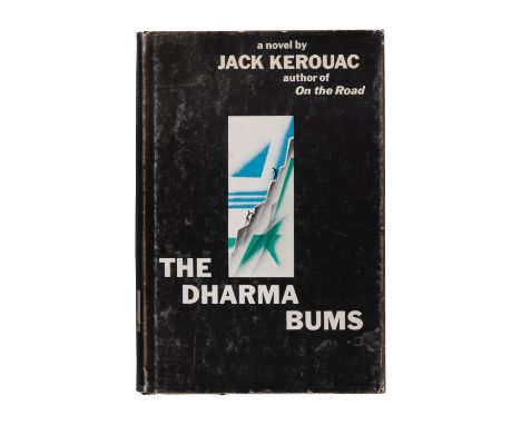
Lot 187
KEROUAC, Jean-Louis Lebris de ("Jack") (1922-1969). The Dharma Bums. New York: The Viking Press, 1958.8vo. Publisher's black cloth stamped in silver and green (small damp stain on front cover); original dust jacket (slight chipping, a few tears with old tape repairs verso).FIRST EDITION, "appearing a year after the author's explosive On the Road put the Beat Generation on the literary map and Kerouac on the best-seller lists" (front flap). Charters A4aFor condition inquiries please contact Gretchen Hause at gretchenhause@hindmanauctions.com
![[TRAVEL & EXPLORATION]. BYRON, John. (1723-1786) Viage del Comandante Byron Al Rededor Del Mundo"¦ Madrid: Imprenta Real](https://cdn.globalauctionplatform.com/14116182-6b38-4f40-9d98-ad0b011c8511/f55d27e1-9f08-4b86-be9e-ad0b01439cd2/468x382.jpg)
Lot 223
[TRAVEL & EXPLORATION]. BYRON, John. (1723-1786) Viage del Comandante Byron Al Rededor Del Mundo"¦ Madrid: Imprenta Real de la Gazeta, 1769.Small 4to (200 x 145 mm). Frontispiece bound facing p.1, engraved folding map hand-colored in outline. (Map with tears to fold crossing image, repairs verso, a few light pencil markings.) Contemporary vellum (hinges separating or starting, some light wear, lacking ties). Provenance: Pedro Robredo y Cia (bookseller's stamp to title-page).Second edition of Casimiro Gomez de Ortega's Spanish translation of John Byron's A Voyage Round the World, in His Majesty's Ship The Dolphin, Commanded by the Honourable Commodore Byron (1767). Ortega was a botanist at the Royal Botanical Garden of Madrid and identified plant species collected during Spanish expeditions to the Americas in the 18th century.Property from the Collection of Gaspar Mayagoitia Barragan For condition inquiries please contact Gretchen Hause at gretchenhause@hindmanauctions.com
![[TRAVEL & EXPLORATION]. SHACKLETON, Ernest Henry, Sir (1874-1922). South. The Story of Shackleton's Last Expedition 1914-](https://cdn.globalauctionplatform.com/14116182-6b38-4f40-9d98-ad0b011c8511/61ea6ca9-2445-4cf5-b223-ad0b0143a818/468x382.jpg)
Lot 224
[TRAVEL & EXPLORATION]. SHACKLETON, Ernest Henry, Sir (1874-1922). South. The Story of Shackleton's Last Expedition 1914-1917. London: William Heinemann, 1919.8vo. Half-title, color-printed frontispiece, numerous photographic plates, folding map (short tear with loss to blank margin), errata slip. (Text slightly browned as usual,.) Original dark blue silver-decorated cloth, top edge stained blue (recased, some light rubbing, endpapers renewed). Provenance: Robert P. Gibb (gift inscription 1919); Henry Sotheran Ltd. (bookseller's label).FIRST EDITION of Shackleton's account of his ill-fated Imperial Trans-Antarctic Expedition. SHACKLETON'S SIGNATURE on a card tipped-in. Conrad p.224; Renard 1460; Rosove 308.A1; Spence 1107; Taurus 105.For condition inquiries please contact Gretchen Hause at gretchenhause@hindmanauctions.com
![[TRAVEL & EXPLORATION]. STEPHENS, John Lloyd (1805-1852). Incidents of Travel in Central America, Chiapas, and Yucatan. L](https://cdn.globalauctionplatform.com/14116182-6b38-4f40-9d98-ad0b011c8511/120e6508-27e0-4407-a71d-ad0b0143d47d/468x382.jpg)
Lot 225
[TRAVEL & EXPLORATION]. STEPHENS, John Lloyd (1805-1852). Incidents of Travel in Central America, Chiapas, and Yucatan. London: John Murray, 1846. 2 volumes, 8vo. 2 lithographed frontispieces, lithographed folding map, numerous lithographed plates. Later tree calf (rebacked, spines somewhat brittle)."Twelfth edition" (stated on the title-page). According to Sabin, there were several reissues of the first American edition "from the same plates, with only slight variations in the collations. London issues appeared in 1842 and 1843." This included at least eleven issues of a "Twelfth Edition" between 1844 and 1871.Property from Historic Sengen House, Cornwall-on-Hudson, New YorkFor condition inquiries please contact Gretchen Hause at gretchenhause@hindmanauctions.com
![[ASIA & AMERICA] -- ORTELIUS, Abraham (1527-1598). Tartariae sive Magni Chami Regni typus. [Antwerp: ca 1570].Engraved ma](https://cdn.globalauctionplatform.com/14116182-6b38-4f40-9d98-ad0b011c8511/25fc5289-dc5d-46d5-becf-ad0b0144b711/468x382.jpg)
Lot 237
[ASIA & AMERICA] -- ORTELIUS, Abraham (1527-1598). Tartariae sive Magni Chami Regni typus. [Antwerp: ca 1570].Engraved map with later hand-coloring of Asia including the west coast of North America, 403 x 518 mm sheet, matted and framed. Strapwork cartouches, one flanked by a woman and a man, ships, and flying fish, Latin text verso.An early depiction of the Kingdom of Tartary, and one of the earliest obtainable maps showing California as an island.For condition inquiries please contact Gretchen Hause at gretchenhause@hindmanauctions.com
![[ASIA] -- MUENSTER, Sebastian (1489-1552). Tavola della Oriental Regione dell'Asia, che Comprende l'Estreme Terre, & Regn](https://cdn.globalauctionplatform.com/14116182-6b38-4f40-9d98-ad0b011c8511/54a22806-079f-4865-a49f-ad0b0144c23d/468x382.jpg)
Lot 238
[ASIA] -- MUENSTER, Sebastian (1489-1552). Tavola della Oriental Regione dell'Asia, che Comprende l'Estreme Terre, & Regni di Quella. [Basel, ca 1550].Woodcut map of Asian with hand-coloring, 278 x 352 mm sight, matted and framed (unexamined out of frame). Mermaid creature and sea monster. Provenance: The Asian Collector (gallery label on back of frame). One of the earliest maps of China based on the geographical discoveries of Portuguese navigators.For condition inquiries please contact Gretchen Hause at gretchenhause@hindmanauctions.com
![[CHINA] -- HONDIUS, Jodocus (1563-1611). China. [Amsterdam, 1606 or later].Engraved map of China, 351 x 470 mm sight, matted](https://cdn.globalauctionplatform.com/14116182-6b38-4f40-9d98-ad0b011c8511/336e73d5-a881-42b3-a5d7-ad0b0144ccce/468x382.jpg)
Lot 239
[CHINA] -- HONDIUS, Jodocus (1563-1611). China. [Amsterdam, 1606 or later].Engraved map of China, 351 x 470 mm sight, matted and framed (unexamined out of frame). Strapwork cartouche, inset depicting a crucifixion, ships, and sea creatures. Provenance: The Asian Collector (gallery label on back of frame).An early map of China, depicting Korea as an island, and showing a small portion of the northwest coast of North America.For condition inquiries please contact Gretchen Hause at gretchenhause@hindmanauctions.com
![[CHINA] -- BLAEU, Willem (1571-1638) and Jan BLAEU (1596-1673).China Veteribus Sinarum Regio. Amsterdam, ca 1640.Engraved map](https://cdn.globalauctionplatform.com/14116182-6b38-4f40-9d98-ad0b011c8511/213e04a0-36c9-4bb1-adb9-ad0b0144e242/468x382.jpg)
Lot 240
[CHINA] -- BLAEU, Willem (1571-1638) and Jan BLAEU (1596-1673).China Veteribus Sinarum Regio. Amsterdam, ca 1640.Engraved map of China, Korea and Japan with hand-coloring in wash and outline, 451 x 593 mm sheet. Figural cartouche showing a woman and a man, Coat of arms, sampans and galleons, French text verso. (Short tear to lower margin, some overall browning from old framing.)Property from the Estate of W.M. Bogdanowicz, Madison, Wisconsin and Naples, FloridaFor condition inquiries please contact Gretchen Hause at gretchenhause@hindmanauctions.com
![[CHINA & SOUTHEAST ASIA] -- HONDIUS, Jodocus (1563-1611). India Orientalis. [Amsterdam, ca 1606-27].Engraved map with lat](https://cdn.globalauctionplatform.com/14116182-6b38-4f40-9d98-ad0b011c8511/52dfdde0-aba7-49c2-9650-ad0b0144edba/468x382.jpg)
Lot 241
[CHINA & SOUTHEAST ASIA] -- HONDIUS, Jodocus (1563-1611). India Orientalis. [Amsterdam, ca 1606-27].Engraved map with later hand-coloring, 370 x 498 mm sight, matted and framed (unexamined out of frame). Strapwork cartouches, galleons and a sea monster, Latin text verso. Provenance: The Asian Collector (gallery label on back of frame).An early Dutch map depicting China and Southeast Asia engraved for Hondius' expanded Mercator Atlas.For condition inquiries please contact Gretchen Hause at gretchenhause@hindmanauctions.com
![[CHICAGO] --Park & Guide Map of Chicago. Chicago: Jas. Van Vechten, 1873.Engraved wall map with hand coloring, 1150 x 820](https://cdn.globalauctionplatform.com/14116182-6b38-4f40-9d98-ad0b011c8511/382fcc21-0666-4871-80df-ad0b0144f98f/468x382.jpg)
Lot 242
[CHICAGO] --Park & Guide Map of Chicago. Chicago: Jas. Van Vechten, 1873.Engraved wall map with hand coloring, 1150 x 820 mm sight, matted and framed (unexamined out of frame, some minor crackling with small losses to top portion of map.)A RARE MAP DEPICTING THE GREAT REBUILDING, published just two years after the Chicago fire, and showing the boundaries of the "burnt district" in red. Lithographed by Jerome T. Gouget, and colored and mounted by G. W. Terry in Chicago (with his ticket). With a street index in accordance with "an ordinance [that] was passed November 25, 1972, naming streets, avenues, courts and places."VERY SCARCE: We do not trace any other copy of this exceedingly rare map at auction in the last 100 years; OCLC locates only two copies, at the Newberry Library and the William Clements Library at the University of Michigan.For condition inquiries please contact Gretchen Hause at gretchenhause@hindmanauctions.com
-
109182 item(s)/page