We found 109182 price guide item(s) matching your search

Refine your search

Year

Filter by Price Range
  • List
  • Grid
  • 109182 item(s)
    /page

Lot 267

A WWI trench map of France, by the Field Survey Battalion, 1:20000 scale, dated 22.8.18, showing German and British Trenches in red and blue, AF

Lot 198

A 19th century gilt framed map of Liverpool

Lot 197

A mid 19th Century hand coloured lithographic comic map of Europe depicting the nations who took part in the Crimean War "Comic map of seat of Europe with entirely new features" published by Rock Brothers & Payne 1854.

Lot 199

A large vintage Dutch school map of Indonesia, 119 x 172cm

Lot 406

An interesting 19th Century hand coloured plan of the proposed “Anglo French submarine railway” across the English Channel, showing longitudinal section, plan view, cross section and map, published by A. MacGregor, Liverpool and Manchester, inscribed in ink “Low and Thomas Wrexham 1868” with ink additions to the map showing various proposed routes from 1857 to 1912, including one by William Low (of Low and Thomas?) in 1867, 16” x 13” in modern gilt frame, GC (some creases).

Lot 45

Wills cigarette English period costume set of 50 framed cards to include framed map of Derbyshire print.

Lot 58

A vintage wall mirror decorated with a map of the world and inscribed, Nova Totius terrarum, Orbis, Geographica, AC Hydrographica Tabvla.

Lot 250

AUTOMATIC DIRECTIONAL ROAD MAP OF GREAT BRITAIN

Lot 54

GROUP OF PRINTS, PICTURES, CORNWALL REPRODUCTION MAP ETC

Lot 41

Boxed brass captain cabin map reader compass

Lot 253

An antique map of North Riding Yorkshire 1657, by W Bleau

Lot 175

A Stanford's Folding Map, Road And Railway Map Of England And Wales 1858 engraved by J & C Walker, in original slip case

Lot 175

ABRAHAM ORTELIUS (1527-1598) MAP OF THE BRITISH ISLES: ANGLIAE, SCOTIAE, ET HIBERNIAE orientated to the right, two cartouches and heraldic shield 34cm x 49cm

Lot 773

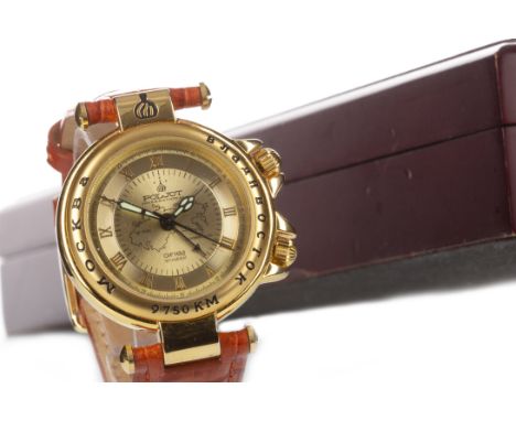
GENTLEMAN'S POLJOT TRANS-SIBERIAN RAILWAY GOLD PLATED MANUAL WIND WRIST WATCH, the round gold coloured dial with Roman numerals, central map of the Trans-Siberian Railway, inner seconds track, outer 24 hour track, lume squelette hands, centre seconds hand, 36mm case, with Russian script and 1891-1904, on a leather strap, in box, with booklet

Lot 1366

A framed Map of Caernarvonshire & Anglesey

Lot 138

J. Russell for Brooks Gazetteer 1793, an Accurate Map of Europe, together with Europe from the best Authorities, in mounts but unframed, 24.5 x 20cm, (2)

Lot 42

Ortellius: Hispalensis conventus a coloured engraved map by H. Chiaues, circa 1588, Spanish text verso, unframed and likely trimmed, 52 x 39cm

Lot 8

Russia (Russiae), North Part of Russia and Moscow, a hand coloured engraved map by Blaeu after Issac Massa, circa 1650, with Dutch text verso, in a mount but unframed, 56 x 44cm

Lot 144

Oban Bay engraved map by J & C Walker, circa 1856, together with the Isle of Zetland, its extent and divisions into Parishes by John Cary, circa.1805, coloured map, various sizes, largest 33 x 19cm, in mounts but unframed (2)

Lot 50

Janvier, L'Amerique, 18th century coloured map with strapwork cartouche, printed in Paris, 1783, contained within a glazed and giltwood frame, 46 x 32cm

Lot 197

A quantity of unframed maps and charts to include the Boundaries of the City of York, An Accurate Map of the County of Bedford Divided into its Hundred's, etc., (a large lot)

Lot 112

Austria (Stiria Steyrmarck) Blaeu, Amsterdam 1662 hand coloured map, with text verso, in amount but unframed, 51 x 38cm

Lot 51

Peregrinationis Divi Pavli Typus Corographicus, Abraham Ortelius coloured map of the travels of St Paul the Apostle through the Mediterranean, framed under glass 50 x 36cm

Lot 249

Middlesex by C & J Greenwood, published London 1829, a map containing coloured panels depicting St. Paul's Cathedral and Westminster Abbey, in a mount but unframed, 67 x 56cm

Lot 12

A Map of the New Roads from Westminster Bridge, an 18th century coloured map, engraved by John Lodge, circa 1753, 36 x 23cm, in a mount but unframed

Lot 61

Moscovy or Russia in Europe, a coloured map by J. Barlowe, in glazed frame 23 x 36cm

Lot 85

A quantity of unframed reproduction prints to include Military Scotland 1890, a New and Accurate Map of Scotland and others etc., (a large lot)

Lot 129

Roma Antica, a folding map in a fitted case together with Early Maps of The British Isles in a blue cloth folio (2)

Lot 106

England - A quantity of unframed maps and charts to include 'An Accurate Map of the County of Bedford Divided into its Hundreds' by Emanuel Bowen, circa. 1760 etc., (a large lot)

Lot 230

Sussex - Coloured map in a glazed frame

Lot 146

A Map of Gaul in the condition it was at the time of the conquest of it by Caesar from the Roman History of Mr Crevier of Roland's Roman History, circa.1745, 31 x 32cm, in a mount but unframed

Lot 2

Glamorganshire: Glamorganensis comitatus vulgo, Johannes Blaeu, engraved map with contemporary hand colouring, this the Latin Edition with ships, circa 1662, text verso, 51 x 38cm, in a card mount but unframed.

Lot 141

Two 18th century copper engraved coloured maps by Thomas Condor, published by Alexander Hogg, to include a New Map of South Wales and a New Map of the Southern part of Scotland, largest 33 x 23.5cm, in mounts but unframed, (2)

Lot 52

Galloway, a coloured reproduction map after Blaeu, in a glazed Hogarth frame, 60 x 50cm

Lot 113

Hungaria Regnum (present day Slovakia & Hungary) Blaeu, Amsterdam 1650 hand coloured map, with text verso, in a mount but unframed 51 x 38cm

Lot 119

The Imperial Map of England & Wales According to the Ordnance Survey, John Bartholomew, 1880, large cloth and leather bound Atlas

Lot 38

John Adair, Holy Island & Fairn Island with the many Rocks & Hazards that ly Scattered in that Sea and the Coast from Sunderland point in England to St Abbs Head in Scotland, a coloured map published Edinburgh 1703, in a mount but unframed, 48 x 37cm

Lot 117

Bartholomew's Revised Half Inch Map Series, a large bound book / folio

Lot 55

British Isles: Insularum Brittanicarum accurata delineatio ex Geographics Conatibus, coloured map, Amstelodani, Joannem Janssonium, after Ortelius, 1650, with strapwork cartouche, in a glazed frame, 51 x 40cm

Lot 176

A quantity of rolled up maps, to include a new map of Scotland or North Britain with the adjacent parts of England and Ireland compiled by the best surveys regulated by the latest observations by Marcus Armstrong, in two parts, etc., (a lot)

Lot 188

A collection of twenty decorative map desk paperweights, boxed (20)

Lot 152

Richardson's New Chart of British Isles, a folding map

Lot 1

Scotland: Evia et Escia Scotis Evsdail - Eskdail a coloured map by Timothy Pont and published by Blaeu, circa 1654, in Spanish over Dutch, mounted but unframed 54 x 43cm

Lot 195

A quantity of map reference books etc., (a lot)

Lot 40

Johann Baptist Homann - Prospect of London and Westminster, (Regions, quae est circa Londinum), hand coloured map to include Hertfordshire, with a vignette of the Thames, in a glazed frame, 57 x 51cm

Lot 43

Audience de Guatimala, 17th century coloured engraved map from L'Amerique en Plusieure Cartes, 28 x 19cm together with Charte der Insel Otaheite, Capt William Wilson Praque 1816, 39 x 28cm, and another, all three unframed (3)

Lot 140

Hampshire Olim Pars Belgarum by William Hole for Camden's Britannia, first edition 1607, hand coloured map, 32.5 x 30cm, in a mount but unframed together with L'angleterre by Robert de Vaugondy, circa. 1766, 23.5 x 25cm, in mounts but unframed, (2)

Lot 37

Staffordiensis comitatus; vulgo Stafford Shire by Blaeu, Amsterdam 1646, contemporary hand coloured map with French text verso, in a mount but unframed, 51 x 43cm

Lot 1142

A Bacon's New Survey Map of the Counties of Northampton, Huntingdon, Cambridge and Bedford

Lot 1035

Robert Morden - engraved and later hand-coloured county map of Suffolk, 36 x 42cm; a reproduction county map of Norfolk; and John Hill - contemporary beach study (3)

Lot 1021

A 19th century French engraved map of Normandy; together with a later engraved map of Africa (2)

Lot 1027

Bacon''s 20th century map of East Anglia, rolled and canvas backed; together with Richardson's canvas backed map of South East & Central England (both a/f) (2)

Lot 171

A collection of framed artwork to include: Mavis Walsh oil on board, similar sketches & framed map plates (7)

Lot 727

An 18th/19th century map of The Fens, framed and glazed

Lot 840

An 18th century hand coloured map of Cambridgeshire, framed and glazed

Lot 839

A map of The Fens and a small hand coloured map of Ely, both framed and glazed

Lot 841

An 18th century map of Cambridgeshire and a 19th century map of Cambridgeshire, both framed and glazed

Lot 220

Emmanuel Bowen - 18th Century map of Cambridgeshire 72cm x 55cm Condition Report & Further Details Click here for further images, condition, auction times & delivery costs

Lot 3103

Follow The Fleet (1936) Belgian film poster, starring Ginger Rogers and Fred Astaire, framed, 24 x 33 inches.Extra Information - Note that this is a rare pre-War Belgian poster. Prior to World War II, Belgian posters were much larger than the ones from after the war, and they are extremely rare (because during WWII, there was a massive paper shortage in Belgium, and they took virtually every poster and map, and printed new posters on the backs of them).

Loading...Loading...
  • 109182 item(s)
    /page

Recently Viewed Lots