We found 109182 price guide item(s) matching your search
There are 109182 lots that match your search criteria. Subscribe now to get instant access to the full price guide service.
Click here to subscribe- List
- Grid
-
109182 item(s)/page


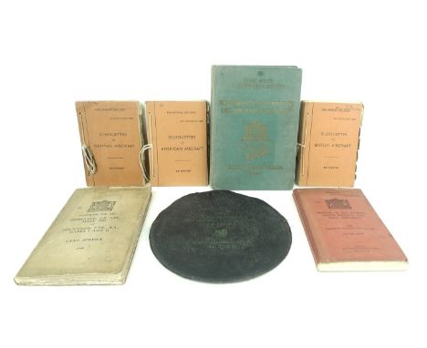
Lot 105
A group of WWII RAF and Army related items, comprising a 'Rude Star Identifier, (with hydrographic office modifications), A-N Type I, Hydrographic Office, number 2102-C, in circular case with four perspex overlays and instructins, three aircraft recognition publications, 'Silhouettes of American Aircraft, Air Publication 1480I', 'Silhouettes of German Aircraft, Air Publication 1480B' and 'Silhouettes of British Aircraft, Air Publication 1480A, all published by the Air Ministry, a 'Handbook for the Ordnance Q.F. 2-PR., Mark VIII on Mountins, 2-PR., A.A., Marks I and II, Land Service, 1940, and a Manual of Map Reading, Photo Reading, and Field Sketching, 1929 (Reprinted with Amendments (Nos. 1 to 4) 1939), The War Office, together with a copy of the Berlin Olympiad, 'So Kampefte Und Siegte Die Jugend Der Welt, XI Olympiad Berlin, 1936', Franz Miller, P. v. Le Fort und Harster, in original gilt lettered green cloth binding.


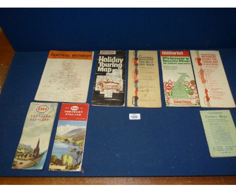
Lot 1299
A selection of old road maps to include; Cyclist map of South West England & South Wales, Esso road maps of Southern Scotland & Northern England, Southern Scotland & Northern England No. 5, Holiday Touring map, Practical Motorist map of GB, Practical motorist Holiday touring Map, Castrol Primary route map of GB, etc.


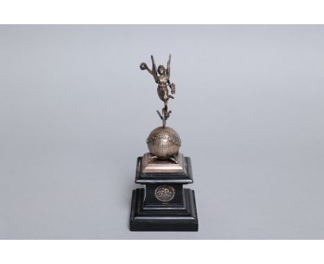
Lot 521A
Previously the property of Ted FrendA FINE MANX GRAND PRIX TROPHY, 1947awarded to D.S. Scott, formed as a silvered model of the Globe and surmounted by a Goddess of Speed, the whole on plinth base with applied Borough of Douglas coat of arms, applied map of the Island and silver applied winners award inscription: 1947 10th Junior Race 70.613 MPH, 20cm in height approximately. For further information on this lot please visit Bonhams.com
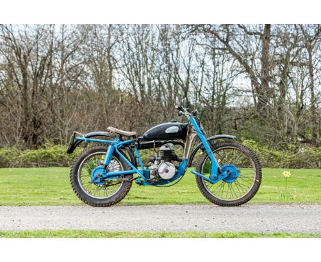
Lot 55
c.1958 Greeves 197cc 20TA Scottish TrialsRegistration no. not registered (see text)Frame no. 9027/TAEngine no. 071B53965Greeves' unorthodox trademarks of a cast beam 'downtube' and rubber-in-torsion leading-link fork proved adaptable to almost all forms of motorcycle from humble commuter to clubman's road-racer, but it was the firm's off-road products that really put it on the map. The off-road range was extensively revised for 1958, gaining new frames with increased ground clearance together with a narrower rear sub-frame and swinging arm. Villiers' 197cc 9E sports engine was used for both the Scottish trials and Hawkstone scrambler, suitably modified to suit the particular application. The name 'Scottish' had been adopted following Jack Simpson's victory in the Scottish Six Days Trial's 200cc category in 1957. The Scottish offered here is fitted with the earlier 8E engine unit, the '071B' prefix identifying it as having been supplied to Francis-Barnett. It should also be noted that the registration '660 FPF' has lapsed and is no longer associated with this motorcycle. Offered with an old-style continuation logbook (issued 1974).Lot to be sold without reserve.For further information on this lot please visit Bonhams.com
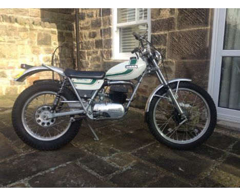
Lot 688
1976 Ossa 244cc MAR Trials MotorcycleRegistration no. UNM 335RFrame no. B333411Engine no. M333411In a bid to emulate local rivals Bultaco and Montesa's off-road competition successes, Ossa hired English trials star Mick Andrews in 1967. Then only 23 but already a proven winner, Andrews set about developing Ossa's existing trail bike into a competitive trials mount, a process that culminated in the MAR (Mick Andrews Replica), which carried its creator to consecutive European Trials Championships in 1971 and '72. The MAR put Ossa on the trials map with a vengeance and proved so successful that it remained in production until the late 1970s. The vendor advises us that this MAR had been run four times in the last year on open roads and twice off-road on local byways, the last occasion being in November 2020. The exhaust mid-section has been replaced and the vendor describes the machine as in generally good condition. Offered with a V5C and MoT (expiring 22nd March 2021).For further information on this lot please visit Bonhams.com
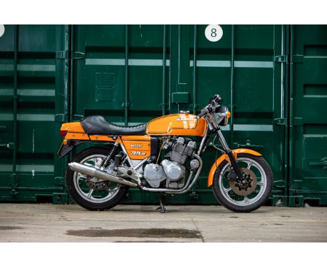
Lot 94
Property of a deceased's estate 1981 Laverda 981cc Jota '120'Registration no. AGT 772WFrame no. LAV1000/3CL 8469Engine no. 1000 8469Blessed with one of the most evocative names in motorcycling history, the Jota was the bike that really put Laverda on the map. Its direct progenitor was the tuned version of the Italian firm's 3C triple - the 3C(E) - developed for production racing by the UK importer, Slater Brothers. The production Jota was both more highly tuned and quicker, its 140mph top speed making it the world's fastest road-going production motorcycle at the time of its launch for 1976. It was also pretty handy on the racetrack, winning the UK's Avon championship in 1976 and 1978 in the hands of Pete Davies. Few major changes were made to the Jota prior to 1982 when a heavily revised version was introduced, complete with a 120-degree crankshaft that made for a more even firing order. This Jota '120' was purchased by its late owner in 2005 (bill of sale on file). An older restoration, the machine displays a total of 35,216 kilometres on the odometer and appears in nice condition. Last MoT'd in 2007, it will require re-commissioning before returning to the road. The history file contains correspondence; photocopies of marque-related literature; technical notes and diagrams; SORN paperwork; pre-restoration photographs; sundry invoices; expired MoTs; original handbook and workshop manual; a V5C; and a Laverda Owners Club 'Highly Commended' rosette from 2006. Currently detached the Jota also includes the front headlight fairing.For further information on this lot please visit Bonhams.com


Lot 17
After John Speede - Map of Northumberland, hand-coloured engraving, 41 x 53cms, in black frame; together with Saxton/Hole - Map of Northumberland, hand-coloured engraving, 27.5 x 30cms; Michael Drayton - Poly-Olbion map of Northumberland and The Bishoprick of Durham, hand-coloured engraving, 27 x 34cms, in black frame; and a 19th Century street plan for Hencoats, 36 x 50.5cms. (4)


Lot 155
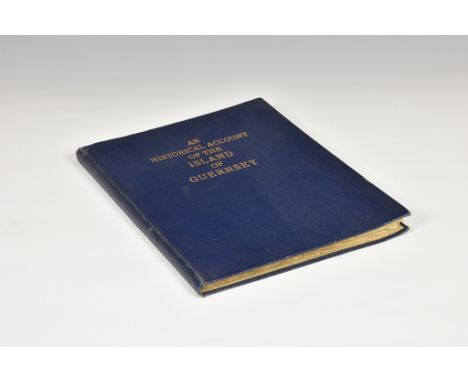
Dicey, Thomas, An Historical Account of the Island of Guernsey, London, for Eglin and Pepys, England map frontis, & six engraved plates, full modern dark blue cloth lettered in gilt to upper. * Map and engraved plates somewhat spotted & browned, text generally good, pencil and pen inscriptions to front pages, light yellowing and staining throughout, slight warping.
Lot 531
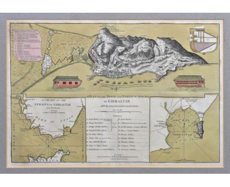
Sayer (Robert) and Bennett (John), A Plan of the Town and Fortifications of Gibraltar with the Spanish Lines, &c., engraved map with inset charts and references and pictorials of the Floating Batteries, with hand colouring, c.1782, 13½ x 20 3/8in. (34.25 x 51.75cm.), framed and glazed; together with a 19th century coloured print of 'The Calpe Hunt Steeplechase, Gibraltar'. (2) * Not examined out of frame. Central horizontal and vertical fold creases. Light mount burn. Sheet slightly cockled and light crease lower left. Clean and bright overall.
Lot 539
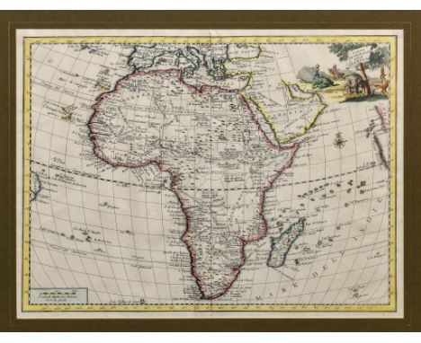
Albrizzi (Giovanni Battista) - Carta Generale Deli Africa, Venice c.1750, double page engraved map with hand colouring, decorative title with hunting scene, 13 x 16¾in. (33 x 42.5cm.). * Provenance: The Map House, Beauchamp Place, London SW3 ** Vertical centre fold. Clean and bright overall, with a little surface dirt and two square tape adhesive marks visible to verso of paper at upper corners.

Lot 551
Zatta, Antonio (1757-1797), 'Le Indie Orientali e il Loro Archipelago', engraved map of Indonesia, pub. Venice 1784, with hand coloured outlines, border and scroll title, 13¼ x 16¼in. (33.7 x 41.25cm.); together with another engraved map by Zatta, 'Regno di Portugallo, pub. Venice 1775, with decorative title and hand colouring, 15½ x 10 3/8in. (39.4 x 26.3cm.). (2) * - Indonesia: Vertical fold to centre, with some associated small creases at lower margin. Otherwise good. - Portugal: Horizontal fold to centre, some handling creasing to lower quarter of sheet. Otherwise good.
Lot 552
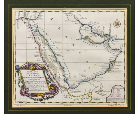
Maurepas (Count de), A Chart of the Coast of Arabia, the Red Sea & Persian Gulf, drawn from the Chart of the Eastern Ocean, Published in 1740, by Order of ye Count de Maurepas...., engraved map with hand colouring, compass rose and decorative title cartouche, 8 7/8 x 10in. (22.5 x 25.4cm.). * Central vertical fold. Otherwise clean and bright.
Lot 555
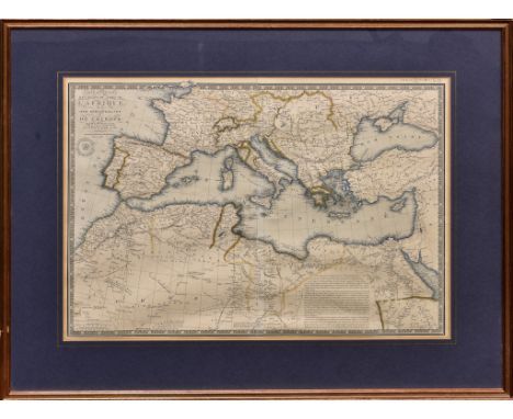
Brue (Adrien Hubert) - Africa, Carte Generale des Etats du Nord de L'Afrique, de la Mer Mediterranée et de L'Europe-Méridionale, engraved map with hand coloured outlines and sea, blind stamp below title, 14¼ x 20 1/8in. (36.25 x 51.2cm.); together with two other 19th century maps of West Africa. (3) * - Brue: Mount burn. Sharp vertical page fold to centre. Paper slightly cockled. - Two maps of West Africa: Light mount burn but otherwise good.
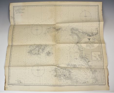
Lot 6
A rare German Kriegsmarine map of the Channel Islands depicting all of the Islands and the French coast, with original document stamps with Eagle and Swastika to front and reverse, the map titled and dated "DER KANAL FRANKREICH, NORDKÜSTE ST GERMAIN BIS CHERBOURG UND KANAL INSELN MASSSTAB 1:150000 HÖHEN UND TIEFEN IN METERN 1907", the bottom of map with "Herausgegeben vom OBERKOMMANDO DER KRIEGSMARINE, Berlin 1907, with highlighted navigational beacons / lighthouses throughout, 30 x 32¾in. (76.2 x 83.2cm.). *The map with stains, edge wear, small rips on folds etc, overall good.
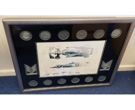
Lot 58
Formula One Mercedes framed Blueprint and Medal Set rare item not available to the general public team issue only 2017 includes A team issue blueprint hand signed by Lewis Hamilton, Valteri Bottas, Toto Wolf, James Allison and Andy Cowell complete and displayed limited edition 645 of 2150 team medal set for the 2017 season comprising of twelve medals with a map of each circuit and the finishing position of the Mercedes driver in each race. Two Large medals celebrating Lewis Hamilton championship win with an engraved signature and race statistics. Good condition Est.
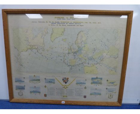
Lot 430
George Philip and Sons Ltd, Dunkirk to Berlin June 1940 to July 1945: Journeys Taken by The Rt. Honble. Winston S Churchill OM CH FRS MP Prime Minister of Great Britain, In Defence of the British Commonwealth and Empire, map print published by The London Geographical Institute, frame size 99cm x 124cm
-
109182 item(s)/page