We found 109182 price guide item(s) matching your search
There are 109182 lots that match your search criteria. Subscribe now to get instant access to the full price guide service.
Click here to subscribe- List
- Grid
-
109182 item(s)/page


Lot 757
THREE BOXES OF BOOKS SUBJECTS INCLUDE MILITARY , HISTORY AND GARDENING ETC, to include Winston Churchill 'The Second World War' volumns 1, 2,4 & 5, three volumns of Winston S Churchill by Randolph Churchill and Martin Gilbert, Winston Churchill the wilderness years by Martin Gilbert, 'Raymonds History of England' by George Frederick Raymond to the summer of 1784 (title page and map are creased, front cover is detached), Municipal diaries for the City of Birmingham from the 1930s to the 1970s, classic works of fiction, Price guide to Pot Lids by Abraham Ball etc


Lot 284
John Speed hand coloured county map of Stafford 'Both Countie and Towne with the ancient citie of Lichfield Defcribed' with 'The Description of Stafford-shire' and 'An alphabetical table of all the towns, rivers and memorable places mentioned in Staffordshire. Appears to be in average/good condition. 56 x 43cm inc frame.


Lot 304
Wild Sports of The Highlands, with Short Sketches of the Wild And Natural History, from The Journals of Charles St John, Esq, London: John Murray, Albermarle Street, 1846, Taylor & Skinner's Survey of the Roads of Scotland, Edinburgh: Thos Brown, 1858 and James Wyld, Scotland fold out map (3)


Lot 319
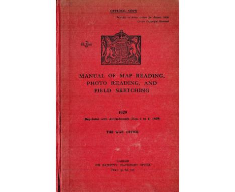
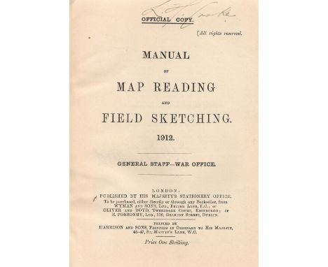
Manual of Map Reading, Photo Reading, and Field Sketching by The War Office 1940 Hardback Book published by His Majesty's Stationary Office some ageing good condition. We combine postage on multiple winning lots and can ship worldwide. UK postage from £4.99, EU from £6.99, Rest of World from £8.99


Lot 26
John Roque (B. 1704–1762) - A large 18th Century French framed and glazed map / plan engraving depicting Chiswick House, London. Hand coloured with various cartouches surrounding the central scene depicting landmarks within the easte. Dated for 1736 with hand coloured detailing throughout. Measures approx; 71cm x 87cm.

Lot 47
Yorkshire.- Richardson (William) The Monastic Ruins of Yorkshire, 2 vol. in 1, 2 lithographed titles, hand-coloured dedication to the Archbishop of York, 56 lithographed plates, many tinted, 19 hand-coloured and mounted on card, folding map, numerous illustrations, some hand-coloured, ex-library copy with bookplate to pastedown and embossed stamp to each plate, in very upper corner or marginal, occasional leaf working loose, scattered spotting, modern half morocco, spine gilt, t.e.g., folio, York, 1843.⁂ A mixture of the deluxe edition (with 33 hand-coloured plates) and ordinary edition (with only tinted plates).

Lot 40
Scotland.- McNicol (Rev. Donald) Remarks on Dr. Samuel Johnson's Journey to the Hebrides, first edition, half-title, occasional light browning, contemporary calf, spine gilt, Printed for T. Cadell, 1779 § Martin (Martin) A Description of the Western Islands of Scotland, second edition, folding engraved map repaired at folds, folding plate, some foxing, later calf, 1716 § Graham (Patrick) Sketches Descriptive of Picturesque Scenery of the Southern Confines of Perthshire; including the Trosachs, Lochard, &c., first edition, half-title, errata slip, contemporary half sheep over marbled boards, rubbed, Edinburgh, 1806, 8vo (3)

Lot 39
Scotland.- Martin (Martin) A Description of the Western Islands of Scotland, first edition, folding engraved map with repaired tear, folding plate, contemporary panelled calf, rebacked preserving original spine, 8vo, Printed for Andrew Bell, 1703.⁂ Johnson and Boswell took a copy of this book on their trip round the Western Isles.

Lot 25
Britain.- Pennant (Thomas) The Journey from Chester to London, half-title, engraved frontispiece and 5 plates, scattered spotting, later half-calf, slight rubbing to corners and extremities, 1811 § Warrington (Rev. William) The History of Wales, folding map frontispiece, one folding map, one folding table, scattered spotting, 2 short marginal tears with old repairs (B3 & P4), faint abrasion and old tape marks to front endpapers, contemporary calf, rebacked, a little rubbed, 1788 § Cirencester (Richard of) The Description of Britain, 2 engraved folding maps, one facsimile, bookplate, contemporary calf, gilt, 1809 § Rastall (W. Dickinson) A History of the Antiquities of the Town and Church of Southwell, engraved frontispiece and 14 plates, small hole to P1, not affecting text, scattered faint spotting, later half-calf, rebacked retaining original backstrip, 1787; and 25 others, Britain, v.s. (29).
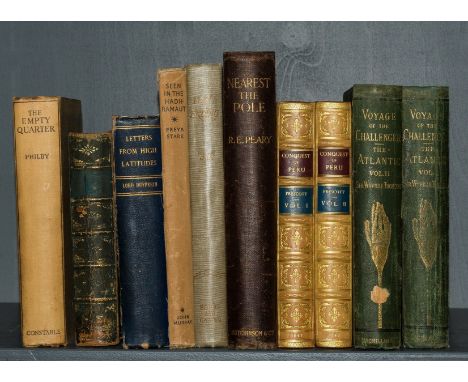
Lot 24
World.- Peary (Robert Edwin) Nearest the Pole, first English edition, frontispiece, plates, large folding colour map at end, scattered faint spotting, original cloth, expert repairs to spine ends and joints, a little rubbed, 1907 § Thomson (Sir C. Wyville Thomson) The Voyage of the 'Challenger.' The Atlantic ..., 2 vol., first edition, portrait and folding map frontispieces, 41 plates only (of 42), illustrations, scattered spotting, original decorative cloth, rebacked retaining original backstrips, rubbed, 1877; and 7 others, travel, 8vo & 4to (10)

Lot 38
Scotland.- Macaulay (Rev. Kenneth) The History of St. Kilda, first edition, folding engraved map frontispiece, advertisement leaf at end, lacking half-title, M1 with repaired tear/hole causing some loss of text, occasional foxing and soiling, later blind-stamped calf, 8vo, Printed for T. Becket and P. A. De Hondt, 1764.

Lot 33
NO RESERVE London.- London and its Environs Described, 6 vol., half-titles, 76 engraved plates, 1 large folding map, short tear with neat repair, 3 folding plans, one with short tear neatly repaired, occasional faint off-setting, occasional spotting, one or two short marginal tears, neatly repaired, new endpapers, contemporary calf, rebacked in morocco, a little rubbed, 8vo, 1761.
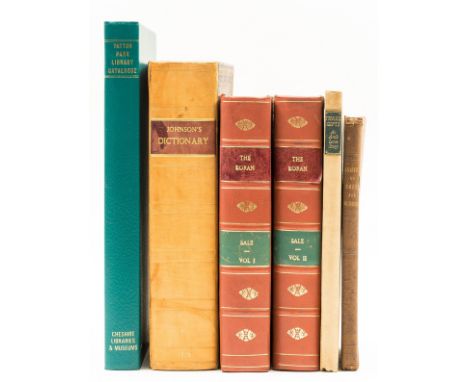
Lot 214
Sale (George, translator) The Koran; commonly called The Alcoran of Mohammed, 2 vol., 4 engraved plates, 3 folding, 1 with tear to foldline, folding map, short tear, scattered spotting, contemporary calf, gilt, rebacked, a little rubbed, 1819 § Ashton (T. J.) A Treatise on Corns, Bunions, and Ingrowing of the Toe-Nail, 5 plates, scattered faint spotting, previous owners ink signature to half-title, original cloth, rubbed and worn, 1852 § Hunter (John) The Works, engraved portrait frontispiece, 61 engraved plates, 6 folding, scattered faint spotting, previous owner's ink inscription, bookplate, contemporary calf, gilt, upper cover detached, rubbed and worn, 1837; and others, 8vo & 4to (9)
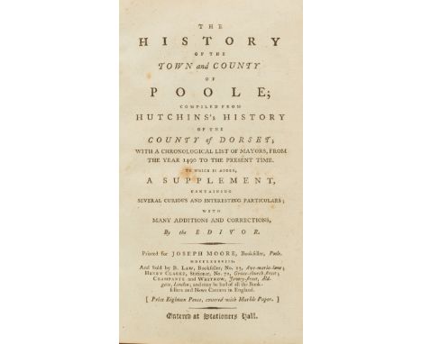
Lot 28
Dorset & West Country.- History of the Town and County of Poole (The), lacking half-title but with errata leaf at end, contemporary half calf, rebacked, Poole, for Joseph Moore, 1788 § Owen's New Book of Roads..., eighth edition, folding engraved map, creased at edges, 1799; Owen's New Book of Fairs, half-title, 1799, together 2 works in 1 vol., contemporary vellum-backed marbled boards, uncut § General Directory for the County of Somerset (A), advertisements at end including one engraved, broken, original cloth-backed printed boards, Taunton, 1840 § Beach and Barnicott, chemists. The Annual Mentor, for 1836, replete with wise maxims and admonitory hints..., 24pp., title with wood-engraved vignette, final with advertisements for medicines, stitched, Taunton, 1836 § Measom (George) The Official Illustrated Guide to the Great Western Railway, second edition, frontispiece and illustrations, contemporary half roan, [1861], all rubbed; and 3 others and a small folder of ephemera, mostly relating to Dorset and the West Country, v.s. (9)

Lot 14
India.- Malcolm (Maj. Gen. Sir John) A Memoir of Central India, 2 vol., vol. 1 folding engraved map (small tear in blank margin), vol. 2 folding engraved map with hand-colouring, contemporary ink ownership inscription to titles, bookplates to front pastedowns, contemporary half calf with morocco labels to spine, extremities lightly rubbed, 8vo, 1823.

Lot 49
Agriculture.- Robertson (George) General View of the Agriculture of Mid-Lothian, 10 engraved plates, of which 1 folding, 1 folding plan, 1 hand-coloured folding map, previous owner's ink notes to Index, contemporary half-morocco, gilt, a little rubbed, Edinburgh, for G. Nicol, 1795 § Brown (Robert) General View of the Agriculture of the West Riding of Yorkshire, folding engraved map, faint abrasion mark where bookplate removed, contemporary half-morocco, gilt, a little rubbed, Edinburgh, 1799 § Holt (John) General View of the Agriculture of the County of Lancaster, folding engraved map, 5 plates of which 1 folding, 2 folding tables, occasional faint off-setting, faint abrasion mark where bookplate removed, contemporary half-morocco, gilt, 1795 § Pitt (W.) General View of the Agriculture of the County of Stafford, hand-coloured folding map, 14 plates of which 3 folding, faint abrasion mark where bookplate removed, contemporary half-morocco, a little rubbed, 1796; 8vo (4)

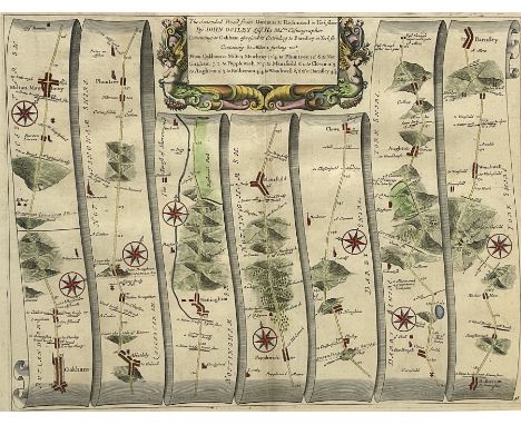
![Channel Islands.- Billet d'Etat XV [2 copies], original printed wrappers, library stamps and manuscript annotations, some lig](https://cdn.globalauctionplatform.com/cb7ef4bf-10fd-4ca6-8c39-ae3201113007/96ce27e3-f423-4f98-b749-ae3201141633/468x382.jpg)
Lot 27
Channel Islands.- Billet d'Etat XV [2 copies], original printed wrappers, library stamps and manuscript annotations, some light finger soiling and toning, lundi le 12 décembre, 1932 § Jersey. Suggestions towards a Civic and Regional Survey, folding map, illustrations, library stamps, printed wrappers, some light toning, 1932 § Civic and Regional Survey of Jersey. Final Report, type-script, manuscript annotations and corrections, wrappers with manuscript title, extremities a little frayed, 1933; and 5 others on the Channel Islands, v.s. (9)
-
109182 item(s)/page