We found 109182 price guide item(s) matching your search
There are 109182 lots that match your search criteria. Subscribe now to get instant access to the full price guide service.
Click here to subscribe- List
- Grid
-
109182 item(s)/page


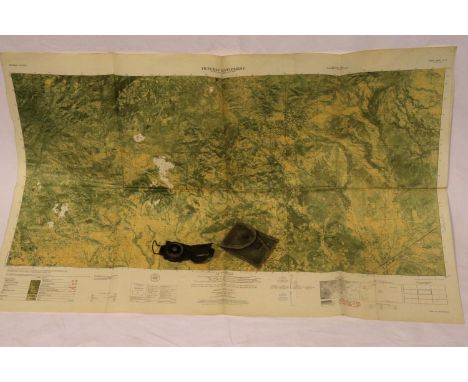
Lot 24
WW2 Superb Battle of Britain Collection Containing Secret Combat Reports, Operational Reports, The Radar Based System of Early Warning, Interception and Control Map. German Fighter Jets Logo Identifier. A Last Appeal To Reason By Adolf Hitler (The Speech Before Reichstag on 19th July 1940). Instructions to Controllers. Printed TLS by Lord Dowding dated 16th May 1940. A Very Large Map. A Fantastic Sought After Collection, Which Gives So Much Information relating to the Battle of Britain. Good condition Est.

Lot 81
Battle of the River Plate, 13th December 1939. Cover designed features HMS Ajax and a map of South America and the Atlantic Ocean in the region of Monte Video, Uruguay, final resting place of German pocket battleship ‘Graf Spee’. Signed bottom right by Able Seaman George Deacon (HMS Ajax, Battle of the River Plate). Envelope includes a typed personal account of the Battle of the River Plate as described by George Deacon. Good condition Est.

Lot 330
Battle of the River Plate, 13th December 1939. Cover designed features HMS Ajax and a map of South America and the Atlantic Ocean in the region of Monte Video, Uruguay, final resting place of German pocket battleship ‘Graf Spee’. Signed bottom right by Able Seaman George Deacon (HMS Ajax, Battle of the River Plate). Envelope includes a typed personal account of the Battle of the River Plate as described by George Deacon. Good condition Est.
Lot 496
AFTER THOMAS ROWLANDSON "A Monkey Merchant" coloured etching 30 cm x 24 cm together with two further coloured etchings "Stern's Journey - the dead-ass" and "La fleur in the Count's Kitchen", AFTER HERMAN MOLL "Westmorland" a coloured engraved map 23 cm x 34 cm together with various other paintings and prints


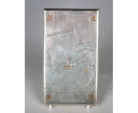
Lot 385
An Edward VIII silver rectangular slide-action cigarette case commemorating the Coronation of 'May 12th 1937', the front engraved with the map of the procession route leading to Buckingham Palace, London 1936 by Asprey & Co Ltd, weight 215.9g, length 14.5cm.Buyer’s Premium 29.4% (including VAT @ 20%) of the hammer price. Lots purchased online via the-saleroom.com will attract an additional premium of 6% (including VAT @ 20%) of the hammer price.


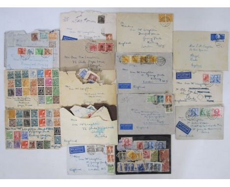
Lot 242
Germany: Collection of immediate post-war stamps, loose in envelope and on cover of early E & W Germany, allied occupation and Berlin issues. Some scarcer defin. & commem. on stockcard cat £1,300+ and better covers cat £700+ along with others inc. Bicentenary of Goethe (SG B61-63), Berlin 1948-1949 issues to 1DM, W German 30pfg UPU on cover (SG1038) & E German Labour day (SG E9). Great variety. Cover made from German map of Spain noted


Lot 47
Cole, G D H & Margaret (ed)"Rural Rides ... Tours in Scotland ... Letters from Ireland ...", William Cobbett, London Peter Davis 1930, limited edition to 1000 sets, not numbered, 2 vols only out of 3, numerous vignettes by John Nash, ep and map of Cobbett's country by A E Taylor, marbled boards, quarter cloth, black pastedown with gilt titles, t.e.g.Cole, G D H (ed)"A Tour Thro' the Whole Island of Great Britain ... by Daniel Defoe, Gent", Peter Davis 1927, limited edition of 1000 copies for sale, not numbered, 2 vols only, marbled boards, vellum backstrip, t.e.g.Walter De La Mare "Stuff and Nonsense", Constable & Co 1927, no.52/275 numbered and signed copies by the author, signed in ink Walter De La Mare, grey boards"An Inward Companion", Faber & Faber 1950, inscription dated 1950 on ffep, dj"O Lovely England and Other Poems", Faber & Faber 1953, green cloth, dj not price clipped"Poems 1901-1918", Constable & Company Ltd 1920, with "Poems 1919-1934", Constable & Co 1935, grey cloth with gilt titles, dj to vol 2 "Come Hither ...", Constable & Co 1923, limited edition 233/350 numbered and signed copies, signed Walter De La Mare in ink, two bkpls inside front board "Come Hither", vol 2 1923, engraved vignette on 2nd ffep, bkpl inside front board, grey boards with quarter cream cloth and pastedown titles, backstrips rather sunned "Crossings, a Fairy Play", with drawings by Gwendoline Raverat, Faber & Faber 1952, pictorial ep, pictorial front board "Peacock Pie", Faber & Faber "Songs of Childhood", decorations by Marion Rivers-Moore 1952, Faber & Faber, blue cloth (14)
Lot 52
Tanner, Right Rev Dr Thomas and Nasmith, James "Notitia Monastica; or an account of all the Abbies, Priories and Houses of Friers, formerly in England and Wales and also of all the Colleges and Hospitals founded before AD MDXL", printed at The University Press by John Archdeacon for John Nichols at Cicero's Head, Red Lion Passage, Fleet Street, 1787, engraved frontis portrait offset on tp, paper water marks on ep, contemporary binding, boards with paper backstrip, backstrip separating, stitching can be seen, pastedown has loss, deckle edges, large folioNavarre Society Limited "The Memoirs of Jacques Casanova de Seingalt ...", with two portraits and 10 photogravures from the original drawings by Antoine Gaymard, privately printed for the Navarre Society 1922, 2 vols, front hinge cracked to vol 1, some foxing to vol 2, cream cloth with gilt titles and gilt rulesBeerbohm, Max"A Survey", William Heinemann 1921, colour frontis tipped in with lettered tissue guard, colour plates tipped in with lettered tissue guards, foxed half title and light foxing on initial pages and two the edges, red cloth, gilt titles, backstrip faded and stain on the front boardThe Broadway Library of 18th Century French Literature"The Private Life of the Marshall Duke of Richelieu ...", George Routledge & Sons 1927, illustrations, green cloth Cheadle, W B and Milton, Viscount"The North-West Passage by Land being a narrative of an expedition from the Atlantic to the Pacific ... by one of the Northern Passes in the Rocky Mountains", Cassell, Petter & Galpin (1865), one map only and nine plates, original green cloth with pictorial image on front board, gilt titles to the backstrip Antiquarian to include:- "The Secret Memoirs of the Duke De Roquelaure written by himself, now for the first time completely translated into English in four volumes", this edition strictly limited to 1,000 numbered copies, privately printed 1896, this edition not numbered, full vellum with gilt rules, edges stained, gilt titles and decorations to the backstrip, backstrips faded"Memoirs of Maximilian de Bethune, Duke of Sully, Prime Minster to Henry the Great ...", 5 vols, printed for A Miller in The Strand ... 1758, full mottled calf, gilt rules, pastedowns missing on backstrips, raised bands, all in need of a bit of tlc, pencil drawing on ffep of vol 1"Macauley's History of England", London, Longman Roberts & Green 1864, marbled ep, half morocco over marbled boards, gilt decorations and raised bands to backstrip, 4 volsWalpole, Mr Horace"Historic Doubts on the Life and Reign of King Richard III", 2nd edition, London, printed for J Dodsley in Pall-Mall 1768, frontis, marbled ep, bkpl inside front board, tree calf, gilt decorations to edges, gilt decorations and titles to backstrip which is separating and has loss, corners bumped"The New Bath Guide; or Memoirs of B-N-R-D Family in a series of poetical epistles", a new edition, London 1801, contemporary marble boards, half-leather, pastedown title and six other volumes
Lot 60
Assorted volumes to include:-"Hertfordshire Illustrated Review", vol 1, 1893, marbled ep, half-calf over boardsKnight, C & Smith P "The History of England", A Fullarton 1879, marbled ep, marbled edges, half-leather with gilt titles and assorted volumes on gardens, topography, Observer books, collecting, etc and an Ordnance Survey map on linen 'Ruislip Parish' (1 box) Condition ReportPlease see additional imageMap folds into covers
![Antiquarian interest - Bunting, Heinrich [Henry Bunting] "Itinerarium totius sacrae scripturae", or The Travels of the Holy P](https://cdn.globalauctionplatform.com/ea96eb8e-b9f0-4004-8242-ae7e0117f369/44c8d728-1b49-4ca4-bdda-ae9500b8c515/468x382.jpg)
Lot 82
Antiquarian interest - Bunting, Heinrich [Henry Bunting] "Itinerarium totius sacrae scripturae", or The Travels of the Holy Patriarchs, Prophets, Judges, Kings, Our Saviour Christ and his Apostles, as they are related in the Old and New Testaments". With a descriptions of the townes and places to which they travelled ... printed by Adam Islip in 1636, cut headers, trimmed, the index is not complete and finishes under S, contemporary inscriptions on all end papers, one dated 1708, scribbles and drawings on end papers, another dated 1741, another 1887, another 1945, the front hinge is separating, stitching visible, contemporary full leather boards lost to the back strip, with [Clark Samuel] [T. Carpenter] "A New Description of the World Colon and First of Europe", this title on page 1B, title page missing, Introduction to the reader by T. Carpenter, woodcut headers, complete descriptions to Italy, Germany, Greece, Africa, America, last page is 212 appears to be the final page, inscriptions on end papers, the end papers are torn, contemporary binding leather separating from the boards, in general poor condition and the "Barclay's Dictionary... greatly improved and superbly embellished", published T. Kinnersley January 1 1813, engraved frontice, the title page engraved, plates, coloured maps, the book has separated at page 514 by the Map of Ireland which is loose, boards detached and five miniature books (8)

Lot 83
Wallis's New Geographical Game, Exhibiting a Tour Through England and Wales", London, published John Wallis 1802, engraved map with contemporary hand-colouring, sectionalised and laid on linen, two columns of rules and town descriptions, 51cm x 66cm, in contemporary card slip case with the publishers printed label, both with worn and split, with small tear on the publishers label Condition ReportPlease see additional image
Lot 92
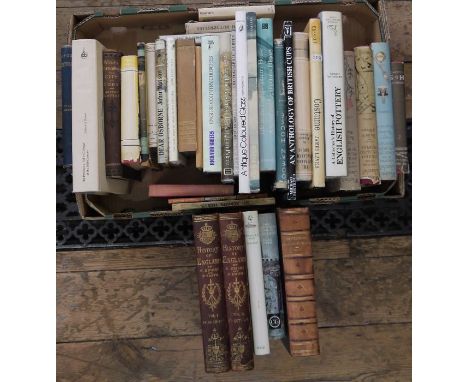
Morris, William "The Story of the Glittering Plain..." Longmans Green & Co. 1894, front hinge cracked, foxing to edges, backstrip and boards faded from shelf wear, "The Sundering Flood" Longmans Green & Co. 1898, the decorative edges rather worn, map, ink name and date 1898 on ffep, red cloth, paste down, some wear "The Water of the Wondrous Isles", Longmans Green & Co. 1897, foxing, front hinge cracked, section cut from ffep, Bell, Malcolm "Sir Edward Burne-Jones A Record and Review" George Bell & Sons 1898, the plates, illustrations the book, has become disbound, pictorial boards and gilt titles, backstrip faded, Hueffer, Ford M. "Ford Madox Brown A Record of his Life and Works", Longmans Green & Co. 1896, sepia frontis with lettered tissue guard, plates, illustrations, foxing throughout, pictorial boards, backstrip faded, Reynolds, Graham "Painters of the Victorian Scene" Batsford 1953, dustjacket, not price clipped, Thorold, Anne (compiled by) "A Catalogue of the Oil Paintings of Lucien Pissarro" 1983, numerous illustrations throughout, green cloth, green slipcase, "Wigs" "The Work of Ambrose McEvoy..." published by Colour Magazine and printed by the Morland Press 1923, frontis small folio, colour plates tipped in and other illustrations, the grey boards are rather stained and backstrip worn, and two other volumes (10)

Lot 107
D'Orbigny, M Alcide "Voyage Pittoresque dans les Deux Ameriques ...", Paris 1836, 2 vols, vignette on tp, frontis, folding map, bkpl inside front board, marbled ep, some offsetting and slight foxing, contemporary blindstamped decorated cloth with gilt rules, gilt titles to the backstrip, corners rather bumped (2)

Lot 110
Stanley, Henry M"In Darkest Africa or the Quest Rescue and Retreat of Emin Governor of Equitoria", Sampson Low Marston Searle and Rivington 1890, frontis to both vols, large folding map in each vol, some loss to the one in vol 1, plates and illustrations throughout, foxing and offsetting, pictorial ep, original contemporary pictorial cloth Stanley, Henry M "Through the Dark Continent", vol 1 only, George Newnes 1899, pictorial cloth"Africa and Its Exploration as Told by Its Explorers ..., Mungo Park - Clapperton - The Landers - Livingston - etc", Sampson Low Marston & Co, 2 vols, numerous plates and illustrations throughout, vol 1 is completely cocked, red cloth with gilt titlesStanley, Richard Neame Alan (ed) "The Exploration Diaries of H M Stanley", William Kimber 1961, grey cloth with dj (6)

Lot 137
Naval history "The Cruise Round the World of the Flying Squadron 1869-1870 Under the Command of Rear Admiral G T Phipps Hornby", J D Potter 1871, folding map frontis, lithographic coloured plates with tissue guards, photographic portrait of 'Her Majesty Emma, Queen Dowager of the Hawaiian Islands ...', hinges cracked at pages 144 and 145, 16 pages of advertising, blue cloth blindstamped, gilt pictorial world to front board, gilt titles"A System of Naval Tactics ... illustrated by coloured figures distinguishing the different columns or squadrons in every evolution", David Steele at his Navigation Warehouse, Little Tower Hill, 1797, engraved frontis, offsetting to tp, has been rebacked with contemporary leather boards laid down, but written initials on the front board, all corners rather bumped and rubbed, marbled edges"HMS Bulwark from 11th June 1905 to January 1907", pamphlet, green covers (3)


Lot 180
WALSH, Rev. Robert.- Notices of Brazil in 1828 and 1829.- London: Frederick Westley and A.H. Davies, 1830.- 2 vols.: il.; 21 cm.- E., Robert Walsh (1772-1852), Irish priest, traveler and historian, chaplain of the British embassies in Saint Petersburg, Constantinople and, finally, in Rio de Janeiro, where he stayed for 200 days, having traveled through the hinterland to find out about the living conditions of black slaves. The collation of each of the volumes is as follows. vol. I: XV, [1 br.], 528 p.: 1 unfolded map, 9 lithographs; vol. II: XII; 541, [1] p.: 1 unfolded map, 10 lithographs. The two folding maps, at the beginning of each volume, represent “Plan of the city of Rio de Janeiro” and “Map of the provinces of Rio de Janeiro and Minas Geraes”. Copy with slight browning and handling, but complete, according to the index. English heraldic ex-libris (cut out): Cornwall. Contemporary Bindings, English made, full sheepskin, with slight wear, borders on the covers, gold tooling on the spines and rools on the squares. Marbled edges, just like the paper of the endpapers. Borba de Moraes, 933 (with extensive news).
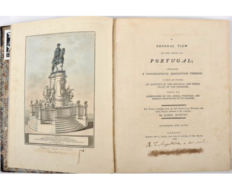
Lot 201
MURPHY, James Cavanah.- A general view of the state of Portugal; containing a topographical description thereof in which are included an account of the physical and moral state of the kingdom, together with observations on the animal, vegetable and mineral productions of its colonies.- London: Printed for T. Cadell Jun. and W. Davies, 1798.- XI, 272 p.: XV gravuras, 1 mapa desdobr.; 31 cm.- E., Original edition of one of the most famous foreign books on Portugal. James Murphy (1760-1814), Irish architect and traveller, native of Blackrock (Cork); in the service of William Burton Conyngham, he was in Portugal during the years 1789 and 1790, with the mission of studying and designing the architecture of the Monastery of Batalha. The author's third work on Portugal, the first two having been published in 1795: “Plans, elevations, sections and views of the church of Batalha...” and “Travels in Portugal through the provinces of Entre Douro e Minho, Beira, Estremadura and Alem-Tejo in the years 1789 and 1790”. It includes a map of Portugal (double, at the end) and 15 aquatints, coloured by hand, representing mainly Portuguese customs and costumes. The location of the engravings and the map strictly respects their original placement, according to the index on pages IX and X. The copy, with good margins, belonged to Rodrigo da Fonseca Magalhães (1787-1858), bearing its white seal and ownership on the title page; another ownership crossed out, on the lower margin, with a stain passing slightly to the next sheet. Some sections with browning, but the engravings are exceptionally clean and fresh. The copies with the hand-coloured engravings are very unusual. Ex-libris of Henrique Botelho. Half-leather contemporary binding (?), with the initials VB gold engraved on the upper cover, keeping the original endpapers in marbled paper. Duarte de Sousa, 509. Foulché-Delbosc, 197 D.
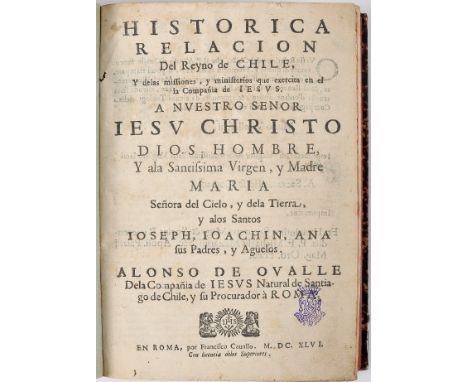
Lot 204
OVALLE, Pe.Alonso de, S.J.- HISTORIA | RELACION | Del Reyno de CHILE, | Y de las missiones, y ministerios que exercita en el | la Compañia de IESVS. | [...] | ALONSO DE OVALLE | De la Compañia de IESVS Natural de Santia- | go de Chile, y Procurador à ROMA.- En Roma: por Francisco Cauallo, 1646.- [8], 455, [1], 10, 12, 6 p.: il.; 25 cm.- E., Original edition of an important description of Chile, illustrated with 14 copperplate prints, nine portraits of knights (governors), 12 portraits of the first generals who commanded the Spanish troops in Chile and 18 xilographic engravings, on the final nine sheets, representing Jesuit schools, churches, ports and Chilean islands. Main work by the Jesuit Alonso de Ovalle (1603-1651), historian and chronicler, born in Santiago de Chile, son of powerful Spanish landowners. The copy lacks the folding map of the province. The work printed in the same year in the Italian version, was only reprinted in 1888 (Santiago), with a circulation of 600 copies. The specimen has some imperfections, the most important of which are: excessive cropping, slight browning and handling; monogrammed stamp with a count's coronet, on the title page; the paper of the copperplate prints is of poor quality and some have small worm holes, most of them marginal. With the exception of the map, it is however complete, corresponding even to the collation indicated to us by Palau. Provenance: Library of Bernardino Ribeiro de Carvalho (lot nº 543 of auction nº 50 of Pedro de Azevedo), with its oval label (ex-libris) on the back cover. Binding from the 19th century, with morocco spine. Sommervogel, IV, 39/40. Palau, 207397.
![[COMPANHIA DE JESUS].- DIVERSI AVISI | PARTICOLARI DALL'INDIE | di Portogallo, riceuuti dall'anno 1551. | fino al 1558. dalli](https://cdn.globalauctionplatform.com/f1954629-257b-4c27-b457-ae9f008ef669/e12ffab0-ecea-42f4-bb71-ae9f009445da/468x382.jpg)
Lot 189
[COMPANHIA DE JESUS].- DIVERSI AVISI | PARTICOLARI DALL'INDIE | di Portogallo, riceuuti dall'anno 1551. | fino al 1558. dalli Reuerendi padri | della compagnia di GIESV. | DOVE S'INTENDE DELLI PAESI, | delle genti, & costumi loro, & la grande con- | uertione di molti popoli, che hanno | riceuuto il lume della santa sede, | & religione Christiana. | Tradotti nuouamente dalla lingua Spagnuola nella Italiana.- In Venetia: per Michele Tramezzino M D LXV. [1565].- [8], 294 f.; 14 cm.- E., Venetian reprint of a set of 54 letters sent by Jesuit missionaries, mainly from Brazil, but also from India, Congo, Japan and China, between 1551 and 1558, to the general of the Society (some to Inácio de Loyola himself) and to his jesuit brothers in Portugal. The edition, published on the initiative of Michele Tramezzino (printer of the first map of Portugal), is dedicated to the Duchess of Urbino, Vittoria Farnese della Rovere, and includes 53 letters sent from numerous places, not only eastern but also western, namely Goa, Malacca, Ormuz, Pernambuco, São Vicente, São Salvador, Cochin, etc. Noteworthy are missives from Saint Francis Xavier, Fr. Luis Frós, Fr. Manuel da Nobrega, etc. Copy slightly cropped, but clean, with only occasional small stains, coated in a recent full parchment binding. Provenance: auction 34, Silva’s/Pedro de Azevedo, December 1999, lot 360 (same copy). STC (Italy), 349. Cordier, p. 48. Palau, 74650 (for the 1st edition of 1558: Se cita otra tirada por el mismo editor pero 1565 que no hemos visto). Borba de Moraes, p. 60.
Lot 183
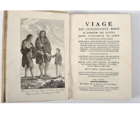
BYRON, Com. John.- Viaje del Comandante Byron al rededor del Mundo, hecho ultimamente de orden del Almirantado de Inglaterra: en la qual se da noticia de varios paises de las costumbres de sus habitantes, de las plantas, y animales estraños... / traducido del Ingles por el Doct. Don Casimiro de Ortega...- Segunda edicion, en que se añade el Resumen Historico del viage emprendido por Magallanes...- En Madrid: En la Imprenta Real de la Gazeta, 1769.- [16], 176, [12], 55, [1 br.] p.: 1 gravura, 1 mapa desdobr.; 20 cm.- E., Second edition of the Spanish translation, published just two years after the original English edition (the first Spanish edition was published in the same year as the second). The work tells the voyage around the world of the English navigator John Byron (1723-1786) who, between 1764 and 1766, commanded the frigate Dolphin, accompanied by the frigate Tamer, through the Pacific Ocean, in search of new continents, having returned to England less than two years after his departure. The translator included at the end a “Resumen histórico del primer viaje hecho al rededor del mundo, emprendido por Hernando de Magallanes, e llevado felizmente á termino por el famoso capitan español Juan Sebastian del Cano”, with its own title page, next to page 176. In his work, Byron highlights the encounter with the giants of Patagonia, in Tierra del Fuego (represented in the engraving next to the title page), previously mentioned by the Portuguese navigator, but never scientifically confirmed. The fold-out map represents the Strait of Magellan in detail. Very clean contemporary binding copy, complete with flexible parchment. Palau, 38230. Borba de Moraes, p. 138.

Lot 101
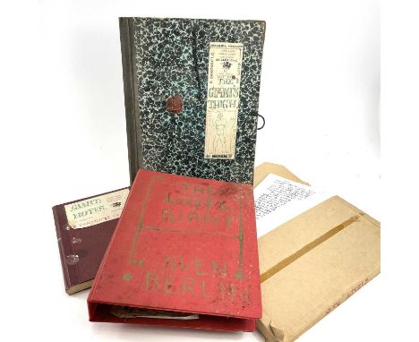
Sven BERLIN (1911-1999)'White Giant: A Chronicle of Love.'A lot of three folders comprising of written works which form Berlin's 1967 unpublished novel 'White Giant'. The lot includes a typescript with handwritten annotations and a hand-drawn map all bound in a folder titled 'The White Giant. Sven Berlin'. Dated 1967-77. A Handwritten manuscript titled, 'Out of The Giant's Thigh. A Chronicle of Love by Sven Berlin'. Signed and dated 1967.Along with the two written works, there is a portfolio folder which is also titled 'The Giant's Thigh. A Chronicle of Love' and is also signed and dated 1967. Also with the portfolio is a small notebook titled 'Giant: Notes'.

Lot 380
An Emanuel Bowen hand coloured engraved map of the six counties of North Wales divided into their respective hundreds, drawn from the best authorities, adorned with views of the Cathedral Churches of Bangor and St Afaph (sic), with description of the dioceses and other improvements, within a border of sheep, goats and cattle in mountainous landscape bottom left, bottom right is a vignette of a view of the Cathedral Church of Bangor and bottom right of Cathedral Church of St Afaph, printed for H Parker & L Bowls in Cornhill, 44 x 54cm, framed and glazed.

Lot 381
JOHN SPEED; a c1610 hand coloured and engraved map of 'Britain as it was devided in the tyme of the Enghfhe Saxons especially during their heptarchy' (sic), British Isles in the centre flanked by cartouches of various kings of the isles with titles and dates, reverse with text, undated, 39.5 x 52cm, framed and glazed.


Lot 384
A hand coloured map of Liverpool, reduced by permission of Mr Gage's elaborate survey, published under the superintendants of the society for the diffusion of useful knowledge, engraved by T Starling, the map with vignettes of the view of Liverpool in 1789, Black Rock lighthouse and plan of Liverpool in 1729, 35 x 38cm, framed and glazed.

Lot 385
A hand coloured map of the County Palatine of Lancaster, titled 'Comitatus Lancastrensis', with illustrated vignette of Neptune lower left and vacant cartouche lower right, 44 x 55cm, framed and glazed (af). CONDITION REPORT There are some small patches, mostly to the left hand side of the map, where the paper is notably paler than the rest of the sheet. Further foxing visible throughout, with minor stains visible around the outer extremities. The centre fold is visible through the entire height of the map.

Lot 595
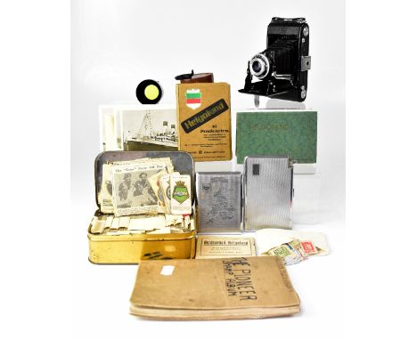
A small quantity of ephemera to include a tin containing various sets of cigarette cards, a small quantity of newspaper clippings relating to WWII, a partially filled 'The Pioneer Stamp Album' with various world stamps (mostly postmarked), two sets of ten postcards relating to Helgoland, various other black and white postcards, some relating to cruise ships, and a set of ten small black and white photographs titled 'Nordseebad Helgoland', also a Zeiss Ikon Nettar 515/2 bellows camera with additional yellow filter, together with two chrome cigarette cases, one engraved with a map of England and the other with integral lighter.

Lot 735
Eleven WWII German bombing maps with a separated colour coded key to the purpose of the location, one map is framed and shows the areas around the Salford Manchester docks, the other ten are rolled, marked 'Sonderausgabe', England 1:10,000, dated 1941, the framed example is 45cm x 55cm, the uncut rolled examples approx 50cm x 8cm (11). CONDITION REPORT The rolled examples have been folded in to quarters and there are old sellotape repairs to most, if not all of the maps, the maps should be handled with care to avoid further splits.
-
109182 item(s)/page