We found 109198 price guide item(s) matching your search

Refine your search

Year

Filter by Price Range
  • List
  • Grid
  • 109198 item(s)
    /page

Lot 230

1950 London Transport Underground quad-royal POSTER MAP designed by H C Beck. With a print-code of March 1950, this issue still shows the planned extensions of the Northern Line to Alexandra Palace and the Bakerloo Line to Camberwell, both of which were subsequently abandoned. Poster was originally folded. Two short sections are starting to part along fold lines, edges are scuffed in places but very reasonable overall. [1]

Lot 327

1940 London Transport Underground quad-royal POSTER MAP designed by H C Beck. A war-time issue which shows the planned extensions of the Central Line to Denham and Ongar and of the Northern Line to Bushey Heath and Alexandra Palace. Poster was originally folded and has suffered somewhat in storage with chafed & scuffed edges and fragility along the folds including small losses at two fold-corners. [1]

Lot 204

1928 London Underground MAP of the Electric Railways of London "What to see and how to travel". December (12/1928) edition designed by E G Perman with elaborate calligraphy of station names and border etc. In lightly-used condition, good apart from a 4" (10cm) fold-parting. [1]

Lot 72

c1931 London Underground linen-card POCKET MAP from the 'Stingemore' series. From the larger series 1928-32, this is the edition with red cover, showing the Piccadilly Line extensions to Sudbury under construction. A very nice copy, just lightly used. [1]

Lot 338

1921 issue of METRO-LAND, published by the Metropolitan Railway. An unusual version which has been bound into a leatherette cover inscribed 'Transport and Travel Monthly'. The double-sided, fold-out map of the railway is present. Minor wear to the extra cover, the booklet itself is in very good condition. [1]

Lot 292

1935 original quad royal POSTER MAP 'London & Suburbs Main Line Railways and connecting Underground Railways of the London Passenger Transport Board'. An early attempt to show London's complete rail network. The main-line companies' lines are shown in blue, red, green & brown with the Underground lines in black. Issuing organisation not shown but presumably the railway companies. Folded with some tape repairs to reverse but very reasonable. [1]

Lot 9

1924 Metropolitan Railway small POCKET CARD MAP "How to get to and from the British Empire Exhibition". Illustration of a new electric locomotive on the cover. Opens out to three panels. This is the green cover version from this series, rarely seen at auction. In lightly-used condition with some age-darkening to cover. [1]

Lot 397

1926 London Underground linen-card POCKET MAP from the 'Stingemore' series. This is the second issue, from the smaller series 1925-27, and is dated Jan 1926 with green cover. This is a good copy, lightly used with a little cover-staining, but overall very respectable. [1]

Lot 369

(London) General Country Services TIMETABLE OF OMNIBUS & COACH SERVICES, Northern Division for Winter, 1932-33. Includes a map of the northern Country Area routes in the centrefold. Has pencilled signature of well-known transport enthusiast J C Gillham inside. In very good condition. [1]

Lot 388

c1902 Central London Railway fold-out POCKET MAP produced by the "Tuppenny Tube" to promote its service from Bank to Shepherds Bush. The line is superimposed in red on a street-map background and shows the generating station and depôt at the western end with an inset plan of the subways at Bank on the top right. The reverse has travel and ticket information. A lightly-used but very reasonable copy. [1]

Lot 33

1919 London Underground MAP OF THE ELECTRIC RAILWAYS OF LONDON 'What to See & How to See it' with print-code 209-500M-18-6-19. Has the black, open, bullseye circle on the cover and opens out in 8 panels to 13.7" x 10.9" (34 x 28cm). One fold, across two panels, repaired with archive tape, otherwise a reasonable copy with light wear. [1]

Lot 348

c1911 London Underground Railways CARD POCKET MAP, considered by many to be the true ancestor of today's Tube map and the first to be printed on linen-card in a handy size. Featuring the vertical UndergrounD logo on the cover, this is a scarce example issued by the Metropolitan Railway, despite the latter not being a part of the Underground Group. In lightly used condition with some wear at the folds. [1]

Lot 245

1911 London Underground POCKET MAP. Printed by Johnson, Riddle & Co Ltd, interesting features are the 3 stations at Hammersmith and the inclusion of the LBSCR lines to Crystal Palace. Places of interest and theatre map on the reverse. In used condition with some scuffs and short tears at the right-hand edge but otherwise very reasonable. [1]

Lot 226

Original 1939 London Transport double-royal POSTER 'Kilburn' showing the entrance to the Underground Station on a local street map (Ordnance Survey-based). Features a superb 'bullseye' logo. Linen-backed, some edge-chafing but generally good. [1]

Lot 291

1924 Metropolitan Railway small POCKET CARD MAP "How to get to and from the British Empire Exhibition". Illustration of a new electric locomotive on the cover. Opens out to three panels. This is the orange cover version from this series, rarely seen at auction. In lightly-used condition with some age-darkening to cover. [1]

Lot 190

1932 London Underground linen-card POCKET MAP from the 'Stingemore' series. From the larger series 1928-32, this is the final edition, with mustard cover, showing all the Piccadilly Line extensions as complete, with 1932-33 opening dates on the reverse along with details of re-naming of Dover St Station and closure of British Museum Stn. Lightly used with a little wear but a good example overall. [1]

Lot 368

1921 Underground Group 'Tramways' POCKET MAP 'Summer Services, May to September'. Designed by MacDonald Gill with his distinctive calligraphy and border. Shows the Underground Group (LUT, MET & SMET) tramways in the north, west and south-west of London incl through-running over LCC tracks. Cover style matches contemporary Underground maps. A little fragile with some folds starting to part in places. [1]

Lot 81

1923 London Underground MAP of the Electric Railways of London "What to see and how to travel". Designed by MacDonald Gill with his distinctive style of calligraphy and map border, this is the issue dated 1/11/23 which shows the British Empire Exhibition stations with red dots. In very good, unmarked condition. [1]

Lot 371

Cook's HANDBOOK TO LONDON with 1911 official LONDON UNDERGROUND MAP. 232pp hard-cover book with illustration of Vanguard motor-bus, taxi-cab & policeman on cover. The map is the classic 1911 UndergrounD issue, showing 3 stations at Hammersmith, the LB&SCR lines to Crystal Palace, places of interest on the reverse. The book has a little wear to the cover-edges but the inside pages are very good and the Underground map is excellent. [1]

Lot 310

1920 London General Omnibus Co double-sided MAP of 'Roads served by Motor-buses' with 'Country Bus Routes with UndergrounD Connections' and a list of services on the reverse. Issued at the International Advertising Exhibition, White City, 1920, presumably as a promotional hand-out to encourage advertising on the buses. Opens out to 26" x 21" (66cm x 53cm). In very good condition. [1]

Lot 46

London Transport POSTER MAPS comprising a 1937 Tram & Trolleybus map (32" x 26", 82cm x 66cm) and a 1951 quad royal 'Central London' map showing Underground, bus & coach routes superimposed on a street plan and featuring the classic 'offset bullseyes' border. Both maps are rather fragile with some fold-tears. [1]

Lot 7

London Transport Tramways POSTER MAP dated May 1935 but designed in 1934 and showing the first unified LPTB network. Varnished and mounted on linen, with wooden poles at top and bottom and secured with a tie-string when rolled, this appears to be an official LT item which was perhaps taken to lectures etc. Measures 33" x 25" (84cm x 64cm). Well used but in good condition overall. A most interesting and unusual item. [1]

Lot 119

1909 London Underground STREET & RAILWAY MAP. A 54-page booklet featuring prominent use of the then recently-introduced UndergrounD logo and incorporating a coloured system map, a monochrome illustration of the 'No need to ask a p'liceman' poster, sectional street plans with the Underground lines superimposed and a street index. In well-used condition with cover staining. [1]

Lot 280

The "District Railway Map of London', 7th edition, dated 1907. The last edition of a series which began in 1873. A large-scale, fold-out map, paper on canvas inside hard covers. The usual worn covers, with some scuffs, but the map is in good condition. [1]

Lot 218

London Transport Underground quad-royal POSTER MAP issued in January 1972. One of the Paul Garbutt issues and a very traditional design with the border of small bullseyes. A couple of small edge-nicks but overall in very good condition. [1]

Lot 163

Quantity of mainly London BUS/UNDERGROUND EPHEMERA comprising 1907 District Railway Map of London, 1930s/40/50s London Transport Und/Tram/Bus pockets maps, 1930s Green Line timetable leaflets, Nov 1947 LT Magazine, 1953 Coronation LT Inspector's 'red book', 1960s/70s provincial bus timetables and 1981 hardback book 'A Source Book of Buses'. In lightly to well used condition. [19]

Lot 76

Original 1934 London Transport quad royal POSTER MAP of 'All Routes - Road & Rail' including buses, trams, Underground and main-line railways, possibly the first issue showing the whole LPTB operating area. These would have been posted at selected bus and Underground stations, enquiry offices etc. A short fold-tear and some corner partings but very reasonable overall. An unusual example. [1]

Lot 375

1919 London Underground MAP OF THE ELECTRIC RAILWAYS OF LONDON 'What to See & How to See it' with print-code 209-500M-18-6-19. Has the black, open, bullseye circle on the cover and opens out in 8 panels to 13.7" x 10.9" (34 x 28cm). A nice example, trace of a pencilled annotation on the cover but generally in good, lightly-used condition. [1]

Lot 230

Bibles - Polyglot: Biblia sacra polyglotta, 1657 vols 1,2 and 4, edited by Brian Walton, three plans of Solomon's Temple and a double-page map of Jerusalem engraved by Wenceslaus Hollar Provenance: Kings College London stamp "this was the most accurate and best-equipped of the great polyglots" (Darlow & Moule). The printing of the work began in 1653, two presses being kept employed, and between 1654 and 1657 all six volumes appeared. Nine languages are represented in the work (including Persian and Ethiopic which had not been included in the three earlier great Polyglots), although no single book of the Bible appears in more than eight versions. "The polyglot Bible was regarded at the time of its appearance as a monument to the intellectual capacity of an English nation previously eclipsed by some of its European brethren. It was also a successful commercial speculation. Though not the first book printed by subscription in England it was one of the earliest and most ambitious" (DNB). Condition Report missing frontispieces etc please phone for further details

Lot 280

'Brittania Map' on collage background, large colour print 60cm x 90cm

Lot 261

18th century silkwork sampler map of England and Wales by Mary Blain 1793 in oval gilt frame 42 cms x 36 cms

Lot 156

BREECHES BIBLE - THE BIBLE THAT IS THE HOLY SCRIPTURES CONTAINED IN THE OLD & NEW TESTAMENTS, starting with the Book of Common Prayer and with Psalmes at end, [88] engraved title, [8] tree of life engraving, [2], 34, [4], 444,13, [14], 114, with double page folding map. Beginning with THE BOOK OF COMMON PRAYER WITH HE PSALTER OR PSALMES OF DAVID, engraved title, Robert Barker, London, 1611, engraved title to Old Testament for Robert Barker, (no date), New Testament title text only and dated 1611, Table for Robert Barker and dated 1612 at end, Whole Book of Psalmes London, 1609, later re-backed leather (title page for Book of Common Prayer and fist page of calendar with restored tears) (1)

Lot 322

Advertising tinplate Sign 'Insignia of Whitbread Houses In East Kent' from a map drawn by D.W. Burley in 1950. Shows in larger panels the towns of Dover, Canterbury, Hythe and Folkestone. Measures 32.5in x 22.5in and is in excellent condition.

Lot 427

Carriage Print British Railways 'Euston Broad Street Watford & Richmond Lines Map'. Framed and glazed, 20in x 10in.

Lot 167

Poster British Railways 'Dorset' by Lander double royal 25in x 40in. Map image of the county showing places of interest with a numbered key below. Published by the Southern Region of British Railways, printed by Ripley & Co.

Lot 483

Poster Great Northern, North Eastern et North British 'Route East Coast - Angleterre et Ecosse' anon c1911, double royal 25in x 40in. A superb Poster, in French, depicting a central map of mainland UK and the route highlighted in red. There are 6 inset images of Durham, Edinburgh, York, Lincoln, London and Peterborough. Printed in England by Chorley & Pickersgill. Professionally mounted on linen.

Lot 464

London Transport LT plastic Display Board with Map of the Piccadilly Line. Shows all the stops on the line, 60in x 7in, slightly curved to fit the Tube Stock above the seats. Good original condition.

Lot 36

GWR Timetable Books, hardback dated 1866 and 1870 together with a GWR 'Ports' book dated 1931. In the latter, one map has a slight tear.

Lot 163

Poster British Railways 'Kent' by Lander double royal 25in x 40in. Map image of the county showing places of interest with a numbered key below. Published by the Southern Region of British Railways, printed by Ripley & Co.

Lot 70

Poster LMS 'The Beautiful & Romantic Holiday Spa Buxton - By LMS' by J.P. Sayer 1932, quad royal 40in x 50in. Interesting Map of the area with cartoon style characters strategically placed and humorous quips added. ERO 53351, printed by S.C. Allen & Co., London.

Lot 161

GWR Poster 'Map of the System' circa 1930's with large roundel logo within, quad royal 50in x 40in. Printed by Waterlow & Sons. Extremely good condition and conserved on paper.

Lot 1442

A framed ''Map of Brittany Duchies 1513'', 26'' x 19 1/2''.

Lot 1197

An Ordinance Survey map in The Dark Ages, second edition together with another map of Roman Britain.

Lot 1013

A print of a Saxton Map of 'Shires Glocestra, Herefordi/e, Breknok', 20 1/4'' x 15 1/4'', framed and glazed.

Lot 1029

A large linen Map of Craswall Farms.

Lot 382

After Lawson Wood, two early 20th century prints entitled 'Whist-Returning a Lead' and 'Cribbage-One for his Nob', (26cm x 19cm) each glazed in wooden frames, together with a Continental oil, village scene signed Van Heck, a map of Nova Scotia and Newfoundland and four prints after Vortigern, each of birds.

Lot 1283

A copy of Saxton Map of Herefordshire and a small Map of Ireland

Lot 1284

A framed ''Accurate Map of Herefordshire divided into it's Hundreds'' by Emmanuel Bowen, 27 1/2'' x 20 1/4''

Lot 1190

A Print of map of Warwickshire, 15 1/2'' x 19 1/2''

Lot 1110

A quantity of miscellanea including decanter label, map measure, etc.

Lot 791

A 19th century needlework map of England on silk in a gilt frame - 51cm x 47cm Condition report: Some perishing to silk

Lot 581

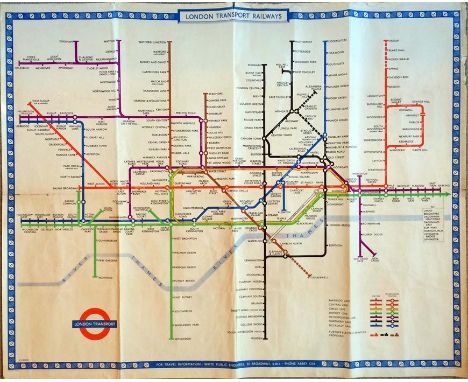
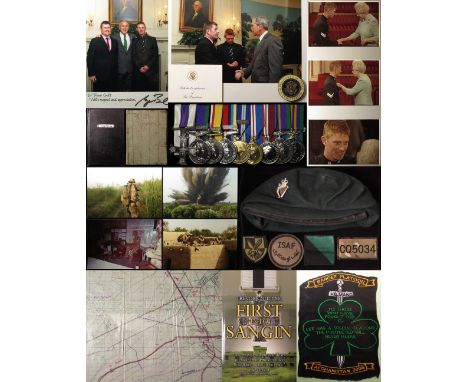
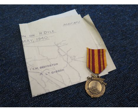
Outstanding Military Cross group court mounted as worn to 25035034 Sgt Trevor (Speedie) Coult Royal Irish Regt - Military Cross (25035034 Cpl T R Coult R. Irish 2006), CSM QE2 for Northern Ireland (25035034 RGR T R Coult R. Irish), Iraq Medal 2004 with 19 Mar to 28 Apr 2003 clasp (25035034 RGR T R Coult R. Irish), Operational Service Medal 2000 with Afghanistan clasp (25035034 Cpl T R Coult R. Irish), NATO Services Medal with ISAF clasp, 2002 Golden Jubilee Medal, 2012 Diamond Jubilee Medal, Accumulated Campaign Service Medal (silver hallmarked) (25035034 Cpl T R Coult R. Irish), and Accumulated Campaign Service Medal 2011 (25035034 Sgt T R Coult 1.R. Irish). Plus two loose Rosettes. Served 1994 - Feb 2015, Cyprus, NI, Canada, Oman, Brunei, Kenya, UAE, Kuwait, Bahrain, Germany, Iraq, Afghanistan, 10 operational tours, over 100 engagements, in 2006 Cpl Coult was involved in Operation Mountain Thurst, on July 16th 200 British Paratroopers were airlifted to take the town (Sangin) and lift the siege, part of the operation was a handpicked platoon from the 1st Bn R.Irish Regt. The lot also includes his Citation 6th November 2005, congratulatory letters from Major R E R Morphew 2006, and Major General G R Coward OBE Commander Joint Helicopter Command, from Peter D. Robinson MP MLA East Belfast, Lieut C Clark RN Equerry to The Duke of York, from Brigadier R L Scott-Bowden MBE ADC (Director of Infantry), from Lieut General J N R Houghton CBE Chief of Joint Operations, and from Colonel W M Campbell OBE Regimental Colonel The Royal Irish Regiment. A photo of Sgt Coult meeting President Bush at the White House (signed by Bush), plus a photo of Bush having just given Sgt Coult the Seal of the President of the United States Medallion on 17 March 2008 (St Patrick's Day) (this also with lot). 3x photos of The Queen presenting Sgt Coult the Military Cross. Plus several photos, his original Map that he carried near the Iraq/Kuwait boarder, two original Diaries kept by Coult for Afghanistan 2008 and Helmand. End of Emergency Tour/Attachment/Detachment Report Mar 06 to Oct 06 Operation Herrick 4. Five large scrapbooks of newspaper cutting kept by his family. Plus Trevor Coult's book 'First into Sangin' published by Xlibris "A very real and gutsy military memoir from a modern day British hero..has to be read" Bob Shepherd. His original manuscript, case for the MC, and his Uniform. His Citation Reads as follows.. Lance Corporal Coult has been employed as a Team Commander in the 1st Battalion The Royal Irish Regiment throughout his Iraq tour. He was a member of the UK Protection Force based in Baghdad, providing security for and escorting the Senior British Military Representatives - Iraq and Senior UK Service personnel. At the time of his tour, Baghdad was the scene for very numerous lethal insurgent attacks against Coalition Forces on a daily basis. On the 6th November 2005 Lance Corporal Coult was a member of an escort task, travelling along Route IRISH form Baghdad International Airport to the Green Zone, assessed to be the most dangerous road in the world. The task consisted of 3 Snatch Land Rovers providing protection for 2 heavy logistic vehicles. Lance Corporal Coult was top cover sentry in the rear vehicle, a role he was conducting for the first time. Approaching Check Point 540 the lead Snatch stopped due to a suspicious vehicle parked at the road side. With a specific and substantial threat form suicide vehicle bomb explosive devices, the top cover sentries in the lead Snatch tried to move the suspicious vehicle, but instead it moved towards the convoy. With a clear and unambiguous immediate threat to life, three warning shots were fired. Despite this activity Lance Cpl Coult steadfastly observed his arcs, not being drawn to the activity at the front of the convoy. With all attention focussed to the front, 3 gunmen opened fire from a flank with extensive automatic gunfire aimed at the stationary vehicles. Lance Cpl Coult immediately realised the complex and dual nature of this lethal ambush. He scanned his arcs and quickly identified the gunmen. Amidst considerable incoming small arms fire, with tracer striking the ground beside the logistic vehicles, he calmly controlled the other top cover sentries, gave precise target information over his personal radio, returned fire and controlled the movement of his vehicle. His accurate and effective fire suppressed the gunmen and enabled the 2 logistic vehicles to extract from the killing zone, thereby undoubtedly saving the lives of the logistic vehicle crews. Lance Corporal Coult’s Snatch remained in the killing zone covering the extraction of the other vehicles, one of which stalled. He ordered his vehicle to be driven alongside the stalled vehicle attracting considerable additional incoming fire. This selfless act saved the stalled vehicle from being immobilised and the crew from becoming casualties. Throughout this complex and well prepared insurgent ambush, Lance Cpl Coult returned proportional, justified and accurate fire, remaining totally focussed, and acted in a considerable, professional and courageous manner. Lance Corporal Coult’s actions undoubtedly save the lives of the logistic soldiers. On his first day as top cover in Baghdad, he showed outstanding judgement, bravery and restraint in returning fire against the enemy. His life saving actions, personal and tactical control, with total disregard to his own safety, are an indictment of the highest qualities of a British JNCO in the face of the enemy and are richly deserving of official recognition'. An excellent lot worthy of inspection.

Lot 279

Dunkirk map 3rd division on R Dykle 11-17 th may 1940 with Dunkirk 50 year Anniversary medal

Lot 53

A VERY RARE CHINESE HAND COLOURED WOOD CUT MAP OF PEKING FOLLOWING THE BOXER REBELLION, circa 1900, mounted as a scroll, showing the division and occupation of the city by foreign powers in the year following the ending of the Boxer rebellion, the laid down map itself 24in high x 20.7in wide.A similar example is held in the Library of Congress. According to the vendor this map was acquired by his grandfather Captain Oswald Tuck in the early 1900’s around the time when he was a naval attaché at the Tokyo Embassy in the Far East; also around that time he was an official observer in the Russo-Japanese war. References to Captain Tuck can be found via an internet search.

Lot 1395

GERTRUDE A. STRICKLER COLORED GRAPHIC MAP, C. 1926, 29" X 37", 'DOWNTOWN ANN ARBOR TOWN'Unframed. Produced by Jesse Horton Koessler (U of M grad, 1901).Folds. Break at folds. JW- For High Resolution Photos visit Dumouchelles website.

Lot 194

A BR(S) mirror showing Southern Region Surburban Services map - approx 40.5x61cm CONDITION REPORT: losses and discolouration to silvering, scratches to surface

Lot 179

George Brannon - Vectis Scenery - published 1846, embossed grey cloth binding with leather spine, map and appendix to rear, 30x25cm. CONDITION REPORT: Scuffing to generally tight binding, slight foxing and staining throughout.

Lot 176

Rev. Edmund Venables - A Guide to the Isle of Wight - published Edward Stanford, 6 Charing Cross, London, with map in pocket, cloth binding with gilt lettering CONDITION REPORT: foxing to pages, cover faded, spine slightly loose, map slightly torn at edges and folds, repaired on one edge

Lot 153

A coloured map, Anglia, an inlaid workbox, three other boxes, two frames, and a stand, applied a carved wood bear (8)

Lot 564

A 9ct gold charm bracelet hung with three full gold sovereigns dated 1876, 1896, 1913, all with soldered on mounts, two half sovereigns dated 1894, and 1914 with soldered on mounts, a George III gold guinea, date too worn to see, and eight further 18ct, 9ct and yellow metal charms to include, binoculars, map of France, thistle, toby jug, enamelled Dutch clog, Genie lamp, baby boots, and a can can dancer, total weight approx 74.9gms

Loading...Loading...
  • 109198 item(s)
    /page

Recently Viewed Lots