We found 109182 price guide item(s) matching your search
There are 109182 lots that match your search criteria. Subscribe now to get instant access to the full price guide service.
Click here to subscribe- List
- Grid
-
109182 item(s)/page


Lot 1672
Visit of the French Fleet, August 1905, programme of Events, gilt blue crushed Morocco, a silk map showing positions of the French and British Fleets, ....., two Edward VII Coronation medallions in silver and bronze, 1902, with the original cases and five other commemorative medallions and coins (9).


Lot 661
A LARGE MAP OF THE SHANHAI PASS, LATE QINGChina, circa 1900. Ink and watercolors on silk. The panoramic vista depicting the garrison town and pass at Shanhai in Hebei Province where the easternmost part of the Great Wall and the Bohai Sea meet, the Imperial Northern Railway to Tientsin also in evidence.Inscribed: Shanhaiguan Yudi Quanti, or ‘Comprehensive Map of the Shanhai Pass Territories’.Provenance: Old German estate, by repute brought home from China by a German soldier and thence by descent in the same family.Condition: Absolutely original condition with wear, creasing, water damage, and losses, possibly trimmed.Dimensions: Size 80 x 160 cm. Modern frame.Shanhai Pass was a fortress built in the Ming Dynasty to defend against the intrusion of Mongolian tribes. It is roughly square with a total length of 4.5 miles, consisting of a 3-mile long wall and a barbican, with four gates at each side. Originally, four separate barbicans were built in front of these gates, forming another defensive layer. This painting shows Shanhaiguan alongside the Great Wall, and in the foreground is the new railway line (built in 1894) with steam locomotives running on the line, the railway station and fortified foreign settlements, including those of the United Kingdom, France, Japan, Russia, and Germany.晚清《山海關地輿全圖》中國,約 1900年。絹本設色。全景描繪了駐軍城鎮和山海關地形圖,長城的最東部與渤海相遇,北至天津的鐵路也很明顯。 款識: 山海關地輿全圖 來源:德國老收藏,據説是購於一德國士兵処,士兵購於中國,自此保存在同一家族至今 品相:絕對原始狀態,磨損,摺痕,水漬和缺損,可能被修剪過。 尺寸:80 x 160 厘米現代框
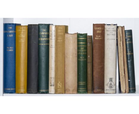
Lot 12
Middle East.- O'Connor (Frederick, Lt.-Col. Sir ) On the Frontier and Beyond, first edition, frontispiece, plates, map, ownership stamp to end paper, original cloth, dust-jacket soiled and frayed, 1931 § Maillart (Ella) Turkestan Solo, first English edition, translated by John Rodker, plates, maps, faded ownership signature to half-title, original cloth, spine soiled, 1934; and 11 others travel, most Middle East and Asia, 8vo (13)
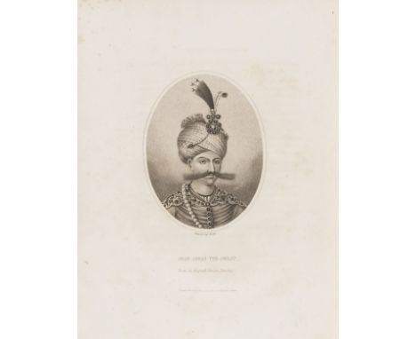
Lot 16
Persia.- Malcolm (Col. Sir John) The History of Persia..., 2 vol., first edition, lacking half-titles but with folding engraved map and 22 engraved plates, some pencil annotations, map lightly browned and torn at edges (repaired, one tear to inner margin with slight loss), light foxing, one plate with heavier foxing and slight fraying to outer margins (repaired), bookplate of John Raynor Arthur, modern half calf over old marbled boards, boards slightly rubbed, 4to, 1815.
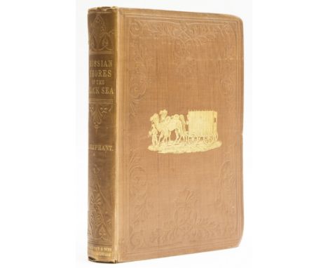
Lot 17
Russia.- Oliphant (Laurence) The Russian shores of the Black Sea..., first edition, half-title, frontispiece and two maps, one folding, short tears and spots to final map margins, original pictorial cloth, gilt, extremities bumped, spine a little faded, else a clean and bright copy, 8vo, William Blackwood & Sons, 1853.

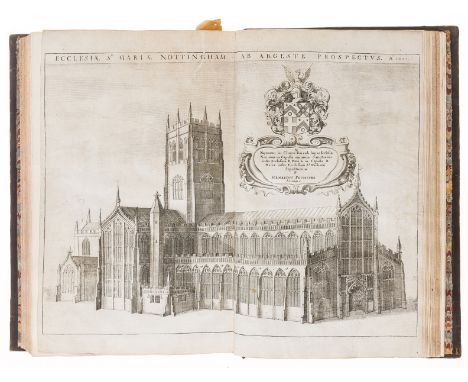
Lot 23
Nottinghamshire.- Thoroton (Robert) The Antiquities of Nottinghamshire, first edition, title in red & black, 8pp. engraved coats-of-arms at end, folding engraved map and 16 plates and plans by Wenceslas Hollar after R.Hall, some double-page and/or folding, many engraved illustrations, some full-page, bookplate to pastedown,1 plate inset at edges onto paper support, some others tipped onto paper stubs, occasional tears, neatly repaired, occasional marginal finger soiling or foxing but overall a good clean copy, 18th century calf, gilt, covers rubbed, extremities and spine worn, [Wing T1063], folio, Robert White for Henry Mortlock, 1677.
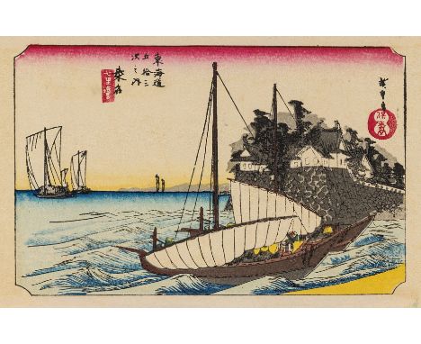
Lot 267
NO RESERVE Hiroshige (Ando) Tokaido 53, 55 colour-woodblock prints, lacking pictorial map, light marginal browning, some folds torn and repaired with tape, other folds weak, original boards in leporello accordion-style binding, a little discoloured, Kyoto, [1936] § The Lark, vol.2 only (of 2), illustrations, some light browning or occasional marks, San Francisco, William Doxey, 1897, first editions; and 10 others, childrens' and illustrated, including a duplicate of the first, v.s. (12)
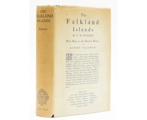
Lot 4
Atlantic.- Boyson (V. F) The Falkland Islands, first edition, frontispiece and 35 plates, folding map at rear, bookplate to pastedown, foxing to frontispiece, title and map, occasional light spotting, original cloth, in the original dust-jacket, spine darkened and stained, some toning to panels and extremities, spine ends and corners chipped, 8vo, 1924.⁂ Rare in the original dust-jacket.


Lot 128
Jacques Nicholas Bellin, 'Carte des Variations de la Boussole et des Vents Generaux que l'on Trouve dans les Mers les plus Frequentees', published. Paris, 1765, world map on a Mercator projection, ordered by Mr. De Choiseul (Minister of War and the Marine), within a glazed frame, 56 cm x 86 cm
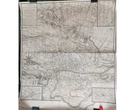
Lot 138
A Topographical Plan of Manchester and Salford, with the adjacent parts, shewing also the Different Allotments of Land proposed to be built on, As communicated to the Surveyor by the respective Proprietors (...), published December 9th 1793, by C. Laurent, the map lined on fabric, 108 cm x 95.5 cm

Lot 6
Phillips (Chas.) Specimens of Irish Eloquence, L. 1819. First Edn., engd. ports. hf. mor.; Gilpin (Wm.) An Essay on Prints, L. 1792. Fourth, cont. tree calf; Paterson - A New and Accurate Description of all the Roads in England & Wales, L. 1811, lg. fold. map frontis & 7 other double page maps, hf. calf, worn; also Universal Gazetteer, sm. 8vo D. n.d. c. 1770, 3 fold. hd. cold. maps by Kitchin etc., cont. calf. As a lot, w.a.f. (4)
![Co. Derry: Colby (Col. Thos.) Ordnance Survey of the County of Londonderry, Part I [All Published] D. 1837, First E](https://cdn.globalauctionplatform.com/f4e1af99-2601-4c42-957a-acca00e9a9d6/4bee573e-5d56-4b93-bc14-accd00adf51d/468x382.jpg)
Lot 108
Co. Derry: Colby (Col. Thos.) Ordnance Survey of the County of Londonderry, Part I [All Published] D. 1837, First Edn., hd. cold. map & other fold. maps etc., also hd. cold. & other plts., text illus. etc. orig. cloth, v. good; [Phillips (Sir Thos.)] Londonderry and the London Companies 1609 - 1629, sm. folio Belfast (H.M.S.O.) 1928. First Edn., cold. & other maps, orig. cloth. V. good. (2)

![[Twiss (Richard)] A Tour in Ireland in 1775, 8vo, L. 1776, First, fold map frontis & plt., with m/ss notes](https://cdn.globalauctionplatform.com/f4e1af99-2601-4c42-957a-acca00e9a9d6/216c558f-98d4-4606-83c6-accd00ae0669/468x382.jpg)

Lot 132
Donn (James) Hortus Cantabrigiensis, or, A Catalogue of Plants Indigenous and Exotic. Sm. 8vo Cambridge 1811. Sixth, hf. calf; Faulkner (Thos.) The Historical and Topographical Description of Chelsea and its Environs, 2 vols. Chelsea 1829, eng.d plts. some hd. cold., fold. map & wd. cut illus., hf. calf, spines dam.; Wraxall (Wm.) Memoirs of the Courts of Berlin... and Vienna, 2 vols. L. 1806, hf. calf. (5)


Lot 17
Maps: England & Wales: Faden (W.) A Map of England, Wales & Scotland, describing all the Direct and Principal Cross Roads in Great Britain… L. 1801, lg. fold. linen backed map, 76cms x 62cms (30" x 24 1/2"), fully hd. cold., slip case; Stanford (Ed.) Railway Map of the British Isles and Part of France, by B.R. Davies. L. c. 1880. Lg. folding map on linen, bright hand colouring, 97cms x 81cms (38" x 32") approx. in slip case; Stanford's Portable Map of England and Wales with The Railways… L. c. 1881, fold. linen backed map, fully hand cold, 83cms x 76cms (32 1/2" x 30"), fold. cloth covers. As maps, w.a.f. (3)


Lot 374
Map: Co. Mayo: Joynt & Son, Ballina Map of Lough Conn and Lough Cullin, Situate in the Parishes of Kilbelfad, Ballynahaglish, Templemore, Turlough, Addergoole & Crossmolina, Baronies of Tirawley, Gallen & Carra and County of Mayo, Lg. hd. coloured engd. map, approx. 59cms x 67cms (26 1/2" x 23") dated 1866, gilt frame. V. good & Rare. (1)
-
109182 item(s)/page