We found 109198 price guide item(s) matching your search
There are 109198 lots that match your search criteria. Subscribe now to get instant access to the full price guide service.
Click here to subscribe- List
- Grid
-
109198 item(s)/page


Lot 190
Staden, Hans: De voorname Scheeps-togten na Brazil, gedaan Anno 1547 en 1549. Nu eerst uyt' Hoogduytsch vertaald na den egten laatsten vermeerderden derden Druk. Leiden: P. van der Aa o. J. (1706). 41,5 x 25,5 cm. Mit gest. Titelvign., 1 gefalt. Kupferkarte und 23 Textkupfern. 2 Bll., 76 Sp., 1 Bl. Mod. Ldr. mit Rv., Rs. und Filetenverg. auf den Deckeln. (Berieben und bestoßen. Etwas gebrauchs- und altersfleckig. Das Kupfer in Sp. 61/62 montiert. Restauriert mit wenigen Ergänzungen im w. Rand.)Sabin 90057. Alden 706/209. Borba de Moraes 786. - Auszug aus Pieter van der Aa's "De Aanmerkens-waardige voyagien door Francoisen ..., Bd. I". - "This edition ... was printed from the same setting of type as the preceeding octavo edition, rearranged to make two columns to a page ... all but one of the copper plates in the octavo edition are included as illustrations in the text of the folio. The map is printed on the same sheet with one of the other maps of this volume" (Sabin).
Lot 140
Hertfordshire.- Clutterbuck (Robert, local historian and landowner, 1772-1831) [Autograph manuscript notes relating to Hertfordshire], autograph manuscript notes signed on 13 pages, excerpts of 4 works on Hertfordshire in 1 vol., including by Thomas Cox (Magna Britannia) and Walker (General View on the Agriculture of the County of Hertford), engraved map of Hertfordshire by Robert Morden, browned, bookplate of Clutterbuck on front pastedown, 19th century half morocco, slightly rubbed, sm. 4to, printed text 18th - 19th centuries & manuscript [c. 1810].⁂ "The impossibility of Witchcraft, plainly proving from Scripture and Reason, that there never was a witch, and that it is both irrational & impious to believer there ever was in which the depositions against Jane Wenham lately tried and condemned, for a witch at Hertford are confuted and exposed. 8vo 1712. Lond." Provenance: Ink inscription of Andrew Coltée Ducarel (1713-85), librarian and antiquary.
Lot 172
Bible, English.- The Bible. That is the Holy Scriptures conteined in the Olde and Newe Testament, titles with woodcut illustration, general title with first two words of title within woodcut entablature, woodcut initials and numerous illustrations in text, double page woodcut plan depicting the temple at Jerusalem, double-page woodcut map of the Holy Land, general title mounted on stub with some restoration to inner margin, [Herbert 144, STC 2118], Christopher Barker, 1576 bound with The Whole Booke of Psalmes, collected into englishe by Thomas Sternh, title within architectural woodcut border, musical notation, final f. creased, [STC 2446], John Day, 1576 together 2 works in 1 vol., double column, ruled in red, the odd chip or tear to margin, occasionally straying into text but without significant loss, occasional light foxing or soiling, ink family notes to endpapers dating from the early 18th century, later morocco, gilt, fillet and roll borders, central decoration with ornamental thistles, neatly and sympathetically rebacked, retaining original backstrip, some rubbing, g.e., folio.⁂ A very good, complete copy of an early folio edition of the Geneva Bible, either the first or second to be printed in England.
Lot 199
Slavery.- Clarkson (Thomas) The History of the Rise, Progress and Accomplishment of the Abolition of the African Slave-Trade by the British Parliament, 2 vol., first edition, 2 engraved plates, 1 folding with short tear, 1 folding map, 2N8 vol. 1 with short marginal tear and neat repair, C4 & N3 vol. 2 with tiny marginal hole, Z4 vol. 2 with short marginal tear, bookplate, previous owner's ink signature, cracked hinges, contemporary calf, a little rubbed, slight bumping to corners and extremities, [Goldsmiths 19725; Kress B.5319], 8vo, 1808.⁂ Thomas Clarkson (1760-1846) devoted most of his life to fighting for the abolition of slavery and toured the country assembling evidence, interviewing 20,000 sailors an acquiring equipment used on the slave-ships.
Lot 249
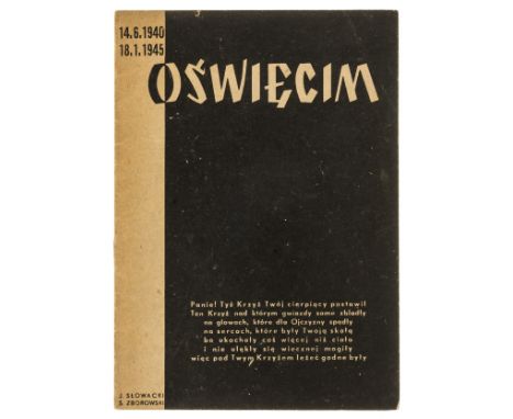
Opening speeches of the Auschwitz Museum in 1947.- Opieka nad Oświęcimiem, only edition, 16pp., illustrations, including a view of the entrance to the camp and an aerial map of Auschwitz, original wrappers, corners and extremities very lightly rubbed, light fading to spine but overall a very excellent copy, 8vo, Kraków, 1948.⁂ A rare and important document, marking the transition from Auschwitz as a concentration camp to its status as a museum. The publication follows the opening ceremony of the Auschwitz museum on June 14, 1947, the official date on which the Government of the Republic of Poland recognized the Auschwitz camp as a museum site. The pamphlet includes transcripts of speeches and letters from senior Polish government officials and survivors on the opening day in a special ceremony held on the day. Among the people appearing are Ryszard Stankowski, a former prisoner in Auschwitz who was a survivor at the end of the war having been on the death row, Dr. Mazimilion Kessler, Chief Executive Officer of the Warsaw Handloby Bank, Dr. Boleslav Rozmarinowicz, President of the Polish Guilds, and Dr. Kazimierz Rudnicki, Prosecutor of the Court of Appeal in Krakow, amongst others.
Lot 272
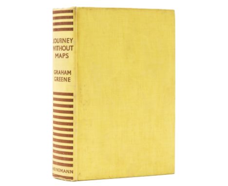
Greene (Graham) Journey Without Maps, first edition, photographic plates, map endpapers, edge spotting, light browning to endpapers, original cloth, light spotting and some splash marks to covers, but a very good, bright example overall, [Wobbe A11a], 8vo, 1936.⁂ Greene's first travel book and one of his rarest titles in first edition.
![Milne (A. A.) [The Christopher Robin books], 4 vol., comprising When We Were Very Young, first issue with contents page unnum](https://cdn.globalauctionplatform.com/7f555423-35bb-47ba-900e-af0400c3d8cc/82c28795-7d19-49ec-87b3-af07011e8aa4/468x382.jpg)
Lot 290
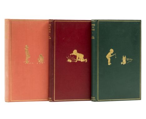
Milne (A. A.) [The Christopher Robin books], 4 vol., comprising When We Were Very Young, first issue with contents page unnumbered, neat ink ownership inscription and light browning to endpapers, slight sunning to spine, splash mark to upper cover, jacket with light toning to spine and panels, spine ends and corners a little chipped, 1 or 2 short tears with light creasing to head and foot, neat and professional tape repairs and strengthening to verso, extremities a little rubbed, preserved in custom drop-back box, 1924; Winnie-the-Pooh, map endpapers (very light browning), jacket with light toning to spine, neat and professional repairs and restorations to spine, corners and along upper fore-edge, repaired tear straying into upper panel, 1926; Now We Are Six, pictorial endpapers, spine slightly darkened, light toning to jacket spine and head of upper panel, spine with chip to foot, minor chipping to tip of spine and corners, some light surface soiling, short nick to head, 1927; The House at Pooh Corner, pictorial endpapers (very light browning), bookplate to endpaper, jacket spine with light toning, minor chipping and light creasing to spine tips and corners, 1928, first editions, illustrations by Ernest H. Shepard, original pictorial cloth, gilt, light rubbing to spine tips and corners, t.e.g., dust-jackets, an excellent set, 8vo.⁂ An attractive set of Milne's classic series.
Lot 291
Milne (A. A.) Winnie-the-Pooh, map endpapers, 1926; Now We Are Six, half-title browned, 1927; The House at Pooh Corner, very light sunning to spine,1928, first editions, illustrations by E. H. Shepard, one or two instances of light marginal spotting or finger-soiling, some browning to endpapers, original pictorial cloth, light bumping to spine ends, very slight shelf lean, overall bright and excellent copies, 8vo (3)

Lot 53
Balkans.- Reusch (Erhard) Alter und Neuer Staat des Königreichs Dalmatien, 2 parts in 1, double-page engraved frontispiece, title in red and black, 46 engraved plates, 2 folding, 1 folding map with short tears to folds, 1 folding text leaf, frontispiece detached with splits to fold and small loss to bottom edge, R8 in part 2 detached and loosely inserted, Z5 in part two with short marginal tear, scattered faint spotting and soiling, errata bound at end, occasional pencil marks and notes to blanks, cracked hinges, near contemporary half-vellum, spine defective but majority of contents holding firm, rubbed and worn, 8vo, Nürnberg, Conrad Monath, 1718.

Lot 66
Asia.- Münster (Sebastian) India Extrema XXIIII Nova Tabula, map of the continent showing from the Arabian Peninsula across India and Sri Lank to China and the Spice Islands, woodcut on laid paper with watermark of bishop's crozier, sheet 297 x 385 mm (11 3/4 x 15 1/4 in), Latin text verso with woodcut borders, small loss in the upper left corner, minor spotting and surface dirt, central vertical fold, unframed, Basel, [circa 1545]⁂ One of the earliest maps of the whole continent based on recent discoveries by Portuguese navigators.
Lot 67
Atlases.- Lizars (Daniel) Lizars' Edinburgh Geographical General Atlas, 68 double-page engraved maps, hand-coloured in outline, with 1 double-page 'Tables of Mountain Chains' map, all mounted on stubs, many with small tears at central fold, some with paper repairs (of which 1 affecting map), c.15 with staining at fold head (a few affecting map), gutter reinforced with tape at title, some light off-setting and spotting, contemporary cloth, rebacked in rexine, soiled and rubbed, folio, 1842.⁂ Including the two rare maps depicting the Republic of Texas between its secession from Mexico in 1836 and its annexation in 1845.

Lot 69
China.- Hondius (Jodocus) China, map of China showing from the Bay of Bengal, across to Korea and Japan, engraving with full hand-colouring heightened with gold, platemark 345 x 460 mm (13 1/2 x 18 1/8 in), sheet 493 x 590 mm (19 1/2 x 23 1/4 in), Latin text verso, even toning and some spotting, central vertical fold with minor splitting to upper section, unframed, [circa 1613-1619]
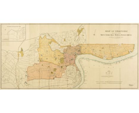
Lot 70
China.- North-China Daily News & Herald (publisher) Map of Shanghai, large English map focussing on the Shanghai International Settlement and the French Concession area, with 'Chinese City located underneath, with certain sites also identified outside of the settlement, including the Siccawei (Zikawei) Observatory and the Shanghai Jewish Club, with numerous businesses, schools, wharves, police stations, public works, and churches identified, and an inset "plan shewing the rubicon road system" in the upper left corner, lithograph printed in colours, 780 x 1540 mm (30 3/4 x 60 1/2 in), mounted on archival support, old folds with some associated splitting repaired, surface dirt, rolled, printed by Waterlow & Sons, 1918⁂ The North-China Daily News was an English-language newspaper in Shanghai, China.

Lot 71
China.- T'ou-sè-wè (Orphanage & Mission Press, Shanghai publisher) Plan de la Concession Francaise - Changhai, map of the developing Shanghai French Concession, showing from Nan Yang University across to the Hunagpu River in the east, including 'Shanghai City' in the lower right quadrant, with contemporary ink inscription in a French hand identifying a 'Dépot' in the lower centre of the map, lithograph printed in colours, sheet 355 x 750 mm (14 x 29 1/2 in), mounted on archival support, old folds with some minor splitting repaired, some spotting and surface dirt, unframed, rolled, Shanghai, 1927⁂ Scarce. We cannot trace any other known impressions of this map having been offered at auction.
Lot 89
Tibet.- Turner (Captain Samuel) An Account of an Embassy to the Court of the Teshoo Lama, in Tibet, first edition, 13 engraved plates, 1 double-page, engraved illustrations, folding engraved map, shot marginal tear, off-setting as usual, Z1 with tiny hole affecting odd letter, 2S3 with small marginal holes, scattered spotting and marginal damp-staining, one or two corrections inserted by hand, previous ownership inscription to title, modern calf-backed boards, 4to, 1800.⁂ Provenance: Lord Beresford's copy, with the inscription "This Book belong to Lord Beresford's Library at Bedgebury Park."
Lot 93
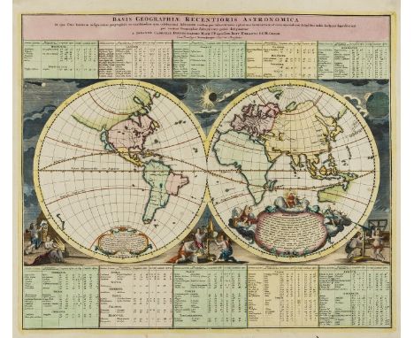
World.- Doppelmayr (Johann Gabriel) Basis Geographiae Recentioris Astronomica in qua Situs Locorum Insigniorum Geographici ea Exactitudine, qua Celeberrimi Astronomi Eosdem per Observationes..., double hemisphere world map showing the continents without political divisions, with California as an island, and only the western and northern coastlines of Australia shown, the surrounds are decorated with vignettes of putto with scientific instruments, and with solar events occurring in the sky, engraving with vibrant hand-colouring, on laid paper with indistinct text-based watermark, platemark 490 x 580 mm (19 1/4 x 22 3/4 in), sheet 530 x 615 mm (20 3/4 x 24 1/4 in), central vertical fold, minor handling creases, scattered surface dirt, unframed, Johann Baptist Homann, [circa 1742]

Lot 94
World.- Heather (William) and John William Norie. To the Officers in the Honorable East India Company's Service This Outline Chart Intended for their Use to prick-off a Ship's Track, a fine blue-backed wall map of the world, extending to include the Americas and Pacific Ocean islands and other revised locations and details, including the 'Sandwich Islands' engraving, on nine sheets conjoined, on cream wove paper fixed onto blue paper support, total map 780 x 1880 mm (20 3/4 x 74 in), some browning and surface dirt, minor perforation to lower left corner, handling creases, some folds with splitting, surface abrasion to left of title, unframed, rolled, originally published by W. Heather, 1812, but with additions to 1830⁂ Revised and enlarged chart of the world published for use aboard East India Company ships, in order to mark a ships track.
Lot 95
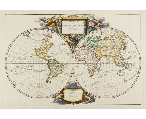
World.- Vaugondy (Didier Robert de) Mappemonde ou Description du Globe Terrestre, double-hemisphere world map with the north-west of North America left unknown, outlines of parts of New Zealand and speculative coastal delineation of the west of Australia, and showing the tracks of the voyages of Bouvet de Lozier (1738-9) in the Antarctic and of Anson (1740-43) across the Pacific 1752, ornate cartouche designed by Cochin and engraved by Tardieu in the upper and lower sections, engraving with full early hand-colouring, on laid paper with watermark and countermark dated '1742', platemark 495 x 730 mm (19 1/2 x 23 3/4 in), sheet 530 x 840 mm (20 7/8 x 33 in), full margins, vertical folds with some minor repairs to splitting, minor nicks and tears to extremities, handling creases light spotting and surface dirt, unframed, Pairs, 1752
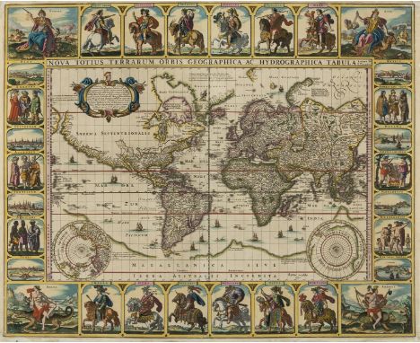
Lot 96
World.- Visscher (Claes Janszoon) Nova Totius Terrarum Orbis Geographica ac Hydrographica Tabula Auctore N. I. Piscator, magnificent carte-a-figures world map on Mercator's projection, an early edition with the dating of Columbus' voyage erroneously described as 1592 to 1599, decorated with panels surrounding the map that include twelve Roman emperors to the top and bottom, six groups of national figures and six vignettes of principal cities to the left and right borders, and each of the four corners with female allegorical representations of the continents, engraving with full hand-colouring heightened with touches of gum arabic, an excellent well inked and early impression, on laid paper without watermark, trimmed to the platemark at the lower edge but expertly re-margined, several small marginal losses and tears expertly restored, notably the upper corners, some minor rubbing and abrasion just off the coast of Florida with careful ink facsimile to some letters, and small repaired perforation to just below Guinea, both areas only really visible verso and under raking light, minor surface dirt, unframed, [Amsterdam, 1652] ⁂ An excellent impression of this scarce world map, known as The Twelve Caesars World Map, both richly decorated with fine engraved details and finished with full hand-colouring.
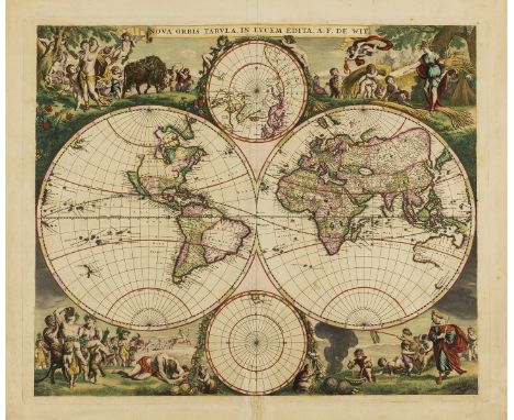
Lot 97
World.- Wit (Frederik de) Nova Orbis Tabula In Lucem Edita, double hemisphere world map, showing the known coastal sections of New Zealand, with California as an island with flat top (before the alterations made c. 1680), large parts of Australia, with two polar hemispheres in the upper and lower centre, and the surrounds elaborately decorated with allegories of the four seasons, the elements and the signs of the zodiac, engraving with full original hand-colouring, an excellent early impression of the first state (of three), printing before the border decoration and later alterations, platemark 480 x 570 mm (18 7/8 x 22 1/2 in), sheet 550 x 650 mm (21 3/4 x 25 1/2 in), central vertical fold with associated minor creasing, some old repairs to minor splitting at fold, minor spotting and surface dirt, unframed, Amsterdam, [circa 1670] ⁂ Important early state of this world map showing the most up-to-date cartographic details known of Southeast Asia and the north of New Zealand.


Lot 1044
Ephemera - a Geo.111 hand drawn and coloured map of 'Land in teh Chapelry of Bradfield and Parish of Ecclesfield called Tinker -Brook' by Wm Barlow Nov. 14th 1796, 1820 Stamp Office Legacy Duty on Residues form, 1856 Property document and two hand drawn and coloured maps for Limbrick Wheels (1815) and Limerick Wheels, on velum, 1912 Mortgage document, Sheffield & Rotherham Red Book and Almanac 1889, The Early history of Stocksbridge & District handbook No.15, etc

Lot 604
Late C19th/early C20th Watkins and Doncaster light mahogany collectors specimen cabinet, the glazed door opening to reveal 20 glazed drawers containing collection of many varieties of small and miniature Yorkshire moths, one drawer empty incl. Ghost Moth, Map Wing Swift etc . H125cm, W55cm, L50cm


Lot 1349
Group of mixed toys to include a boxed Subbuteo 60140 set, incomplete (includes reds & blues starter teams - missing one red player, and a complete QPR team), a boxed Brio wooden railway set no. 33145, Brio wooden railway bridge, 3 x boxed Waddingtons Jig-Map jigsaw puzzles, boxed Empire dominoes, and a KG Games Kick Off jigsaw puzzle, together with an Esso 100 Years of Football Centenary Medals set (3)


Lot 174
RICHARD MARX platinum display. A framed display commemorating the sale of more than 6,000,000 units worldwide of 'A Repeat Offender' by Richard Marx, presented to EMI Italia director Alexis Rotelli, 1989-1991, six platinum 12" vinyl backed onto a map of the world, framed and glazed. 86cm x 124cm


Lot 365
A large collection of topographical books, including Manby, G.W.: An Historic and Picturesque Guide From Clifton Through the Counties of Monmouth, Glamorgan, and Brecknock, later half leather binding and bookplate for John & Myfanwy Piper; The Author of The Antiquities of Furness: A Guide to the Lakes in Cumberland and Westmorland, Fifth Edition, 1793, full leather bound and bookplate for Earl of Portarlington; Walpoole, George Augustus and Dalton, William Hugh: The New British Traveller, full leather binding, Thomas Kitchen map of England and Wales, and other topographical plates; Farnham, Thomas J.: Life and Adventures in California and Scenes in the Pacific Ocean, Publ. Wm. H. Graham 1846; and other leather, half leather and cloth bound books from the 19th and early 20th century


Lot 262
Five Boxed French Dinky Military Toy Models, 817 CHAR A.M.X. 13 Tank, 821 Mercedes Benz Unimog Army covered wagon, 827 Panhard FL10 complete with aerial, loose packet, inner packing, one end flap torn,883 AMX 13 Bridge Layer, complete with instruction leaflet , metal parts have surface rust, with illustrated lidded box, in fair original condition, tear to one end of lid, 884 Military Brockway Bridgelayer, with plastic bridge sections, 2x inflatable boats, in good original condition, with original blue/white Supertoys box, which is fair, missing leaflet/map and inner packing, models are dusty where they have been on display, fair to excellent, boxes are fair, 817 box is poor.(5 items)

Lot 277
French Military Dinky Toys 883 AMX 13 Bridge Layer, in illustrated lidded box, in good original condition, dusty where model has been on display, some surface rust to metal parts, reproduction instruction leaflet and 884 Military Brockway Bridge-layer, with plastic bridge sections, 2x inflatable boats, instruction/map leaflet, in excellent original condition, with original blue/white Supertoys box, which is very good, complete with inner packing. (2 items)
Lot 225
W.Monk-An antiquarian print of a post tudor building, signed in the lower right margin, limited edition animal prints by Gary Hodges and a map of Derbyshire, mixed prints, a Folio Society book 'The Sun King and his Loves' by Lucy Norton 1982 and an 1893 2nd Dragoons- The Royal Scots Greys 1678-1893 illustrated book

Lot 426
Mixed ephemera to include 1920's newspapers and magazines, motoring and hiking maps, a large school room map of the world, scrap book cut-outs, children's books to include Laurent de Brunhoff Picnic at Babar's, Orlando the Marmalade Cat and others, along with 1963 and 1989 Playboy magazines Location: 1.5
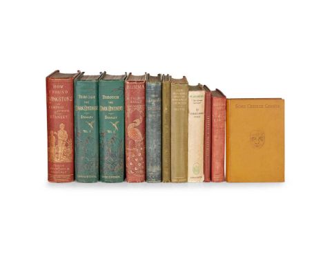
Lot 1
Africa and Asia Collection of travel narratives, 19th century Portal, Gerald H. An Account of the English Mission to King Johannis of Abyssinia in 1887. Privately Printed. Winchester: Warren and Son, [1888]. First edition, 8vo, original green cloth, inscribed 'with the compliments of the author, Cairo, Oct. 6, 1888', slightly rubbed;Irwin, Henry Crossley The Garden of India; or Chapters on Oudh History and Affairs. London: W. H. Allen & Co., 1880. First edition, 8vo, original cloth, half-title, 36 + [4] pp. advertisements, inscribed 'For Will and Mabel, with the writer's love, May 1880' on half-title, Crossley family bookplate, covers water-damaged, spotting to early leaves and occasionally elsewhere;Sykes, Christopher. Wassmuss, "The German Lawrence". London: Longmans, Green and Co., 1936. First edition, 8vo, original cloth, with the scarce dust jacket, 12 photographic plates by Robert Byron and others, spine rolled, dust jacket slightly chipped, rubbed and marked;Stanley, Henry M. Through the Dark Continent, or the Sources of the Nile. New York: Harper & Brothers, 1879. First US edition, early issue, 2 volumes, 8vo, original green pictorial cloth gilt, all plates and maps as called for (including 2 large folding maps in end-pockets), front free endpapers excised, damp-staining to plates, rear inner hinges cracked, folding maps with small holes to intersections of folds;Idem. How I Found Livingstone: Travels, Adventures and Discoveries in Central Africa. Published only by Subscription. New York: Scribner, Armstrong & Co., 1872. First US edition, 8vo, original red-brown pictorial cloth gilt, all plates and maps as called for, frontispiece map torn but all present, folding map facing p. 475 possibly lacking bottom section, spotting;Beeton, S. O., and Ronald Smith. Livingstone and Stanley. An Account of Dr. Livingstone's Early Career, his Travels and Discoveries. London: Ward, Lock, and Tyler, 1872. First edition, 8vo, contemporary red-brown cloth, 3 wood-engraved plates including folding portrait, original front wrapper (with map) bound in;and 4 others similarNote: Note: The US edition of Through the Dark Continent was first published in 1878. Library Hub traces five copies only for Beeton and Smith's work
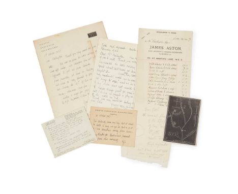
Lot 105
Gill, Eric (1882-1940) 2 autograph cards, 1 autograph letter and 1 wood-engraving Autograph card signed to Mr Wilfrid Partington [of The Bookman's Journal], discussing who Gill could suggest to write an article on his wood engravings. 'Really, it is v. difficult to say. Lots of kind people buy them but who could write about them ? & why shd. anyone want to ?' Gill goes on to suggest M. l'abbé Desmond Chute in Rapallo and Geoffrey Keynes 'the former, a v. good artist himself, would have the more intimate view', 2, 5. [19]25; further autograph card initialled, acknowledging receipt of The Bookman's Journal;Autograph letter signed to Mr Partington, stating that he has left Wales for Pigotts and saying he encloses a map for his guidance, 11th October 2029;Wood-engraved map of Pigotts, North Dean, High Wycombe, Bucks., by Eric Gill, 11.5 x 8.2cm;Autograph letter signed from Mary Gill to Mr Partington, saying that she remembers the little carving but has no idea who bought it and that she has very little of his work as he usually did work to order 'but I think he found a joy in most of the work he did', 2nd Feb. 1944;and 1 other item (Eric Gill, 'The Enormities of Modern Religious Art', offprint from The Month, 1928)Note: Provenance: Property of an English collector.
Lot 11
Middle East and Asia Collection of travel narratives ex libris Lt S. C. R. Duffy all 8vo, original cloth, and with Duffy's ownership inscriptions (dated Liverpool, Bombay or Jubblepore), a few titles further annotated with various dates on front free endpaper (apparently denoting re-readings), and comprising:Hale, F. From Persian Uplands. London: Constable and Company Ltd, 1920. First edition, map endpapers, half-title and final leaf browned;Sykes, Ella & Sir Percy. Through Deserts and Oases of Central Asia. London: Macmillan and Co., Limited, 1920. First edition, all plates as called for, folding map in end-pocket, errata slip; Dickson, William Edmund Ritchie. East Persia. A Backwater of the Great War. London: Edward Arnold & Co., 1924. First edition, 8 plates, folding map, spine rolled, covers slightly marked, cancelled library plate to rear pastedownPhilby, Harry St John Bridger. Arabia of the Wahhabis. London: Constable & Co., 1928. First edition, all plates as called for, large folding map (with short closed tear), half-title browned, edges spotted;Younghusband, Sir Francis. Peking to Lhasa. The Narrative of Journeys in the Chinese Empire made by the Late Brigadier-General George Pereira. London: Constable and Company, Ltd., 1925. First edition, all plates and maps as called for, library markings removed from front board and rear pastedown, rear inner hinge tender;and 9 others (these not collated), including: Olufsen, Through the Unknown Pamirs, 1904 (first edition in English); Tate, The Frontiers of Baluchistan, 1909 (first edition); Forbes-Leith, Checkmate: Fighting Tradition in Central Asia, undated; Maynard, The Murmansk Venture, undated; Blacker, On Secret Patrol in High Asia, 1922 (first edition, annotated 'The Bajgiranski Soviet, Miss R. P. Houston, Major L. V. Blacker, Capt. H. C. Duncan, Lt S. C. R. Duffy' on front free endpaper, front inner hinge tender); Etherton, Across the Roof of the World, 1911 (first edition, contemporary cloth); and similarNote: Note: S. C. R. Duffy was gazetted lieutenant, Indian Army, on 29th August 1919. His Wolseley helmet was sold at a UK auction in 2021. Hale's From Persian Uplands appears to be scarce in libraries and in commerce.
Lot 12
Miniature atlas Atlas minima, comprehended in 30 Maps Edinburgh: Alex Macredie, c.1825. Oblong 16mo (9.5 x 6.4cm), contemporary red half morocco, title-page, contents leaf, 30 maps by W. Murphy, engraved throughout, the maps hand-coloured in outline, extremities rubbed, rear board detached, juvenile pencil-markings to endpapers, title-page, index leaf and several maps (mainly on versos, and very faint where on rectos), ink inscription to front pastedown offset onto title, small ink-stain to Europe map. Together with an 18th-century almanac (The Polite Repository or Pocket Companion, London: W. Peacock, 1796, 12mo, original red morocco wallet binding, engraved frontispiece and headpieces depicting country seats, and S. Leigh Sotheby & Co., Catalogue of the Important Collection of Manuscripts from Stowe, which will be sold by Auction by Messrs. S. Leigh Sotheby & Co., on Monday 11th of June 1849. 8vo, with earlier engraved portrait of the Duke of Buckingham bound in, two engraved plates, modern blue cloth library bindingNote: Note: Library Hub traces two copies only of the Atlas Minima, British Library and National Library of Scotland (providing different dates).
![Scotland Collection of early travel narratives [Thomson, William]. A Tour in England and Scotland, in 1785. By an English Gen](https://cdn.globalauctionplatform.com/3c24d1d9-bd7d-4906-af55-aef3010948a3/189365fc-ad89-44c5-ae9f-af0200ed17c1/468x382.jpg)
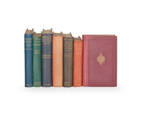
Lot 14
Scotland Collection of early travel narratives [Thomson, William]. A Tour in England and Scotland, in 1785. By an English Gentleman. London: for G. G. J. and J. Robinson, 1788. First edition, 8vo, contemporary calf, half-title, 6 engraved plates, binding worn, a few stains and marks to contents, free endpapers excised, contemporary ownership inscriptions to half-title [ESTC T145931];Lettice, John. Letters on a Tour through Various Parts of Scotland, in the Year 1792. London: T. Cadell, 1794. First edition, 8vo, 19th-century blue-green half calf, rubbed, light toning, shallow damp-stain to head of gutter at front [ESTC T146987];Murray, Sarah. A Companion, and Useful Guide to the Beauties of Scotland, to the Lakes of Westmoreland, Cumberland, and Lancashire; and to the Curiosities in the District of Craven. London: for the author, 1799. First edition, 8vo, contemporary half calf, worn, half-title discarded, prelims misbound [ESTC T147827];Troil, Uno von. Letters on Iceland ... made during a Voyage undertaken in the Year 1772, by Joseph Banks. Dublin: by G. Perrin, for S. Price [and others], 1780. First Dublin edition, 8vo, contemporary sprinkled calf gilt, half-title, engraved frontispiece, engraved folding map, bookplate of the Barons Cloncurry ('Lyons Library'), slightly rubbed, small nick to head of spine, light spotting to map and adjacent text-leaves, an attractive copy [ESTC N138];[Heron, Robert]. Scotland Delinated, or a Geographical Description of Every Shire in Scotland ... for the Use of Young Persons. Edinburgh: for James Neill, 1791. First edition, 8vo, contemporary calf, engraved folding map (torn in margin) [ESTC T83697];[Botfield, Beriah]. Journal of a Tour through the Highlands of Scotland during the Summer of MDCCCXXIX. Norton Hall [Northamptonshire]: [for the author], 1830. First edition, 8vo, later maroon calf gilt by Riviere, engraved frontispiece and additional title-page (both spotted), bookplate of the Dukes of Argyll;Necker de Saussure (Louis Albert). A Voyage to the Hebrides, or Western Isles of Scotland. London: for Sir Richard Phillips, 1822. First edition in English, 8vo, 20th-century cloth, 5 aquatint plates, edges untrimmed, spotting;and 7 others (these not collated), including: Thomas Pennant, A Tour in Scotland, and Voyage to the Hebrides, MDCCLXII, Chester, 1774 (4to, contemporary half calf, worn, engraved plates); John Ogilvie, Rona, a Poem, 1777 (first edition, 4to, contemporary tree calf, spine worn, front board detached, engraved folding maps, 7 plates, one damp-stained); The Traveller's Guide through Scotland and it's [sic] Islands, Edinburgh, 1806 (third edition, 8vo, contemporary red half morocco, maps); The Tour of the Duke of Somerset ... through Parts of England, Wales, and Scotland, in the Year 1795, 1845 (8vo, contemporary maroon morocco by Hering); Sir Donald Monro, Description of the ... Hybrides, 1884 (original cloth, one of 250 copies); and similar
Lot 171
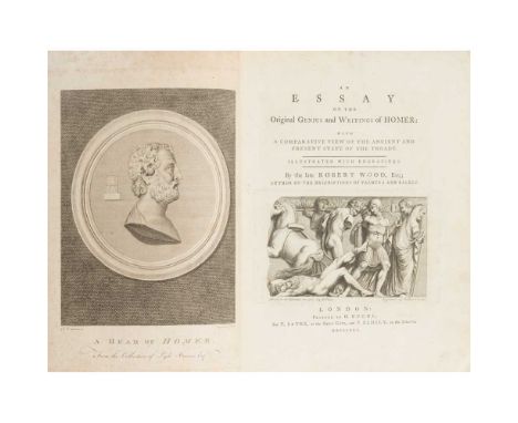
Wood, Robert An Essay on the Original Genius and Writings of Homer with a Comparative View of the Ancient and Present State of the Troade. London: for T. Payne and P. Elmsly, 1775. First edition, 4to, engraved frontispiece, folding map and 3 plates (1 folding), contemporary calf, g.e., neatly backed, corners rubbed, bookplate of John Fowke Lancelot RollestonNote: Provenance: From the library of the late William St Clair, FBA, FRSL.
Lot 19
Agriculture Group of English county surveys, 18th-19th century Middleton, John. View of the Agriculture of Middlesex. London: by B. McMillan for G. Nicol [and others], 1798. First edition, 8vo, 20th-century green half morocco by Bayntun, 2 hand-coloured engraved maps (both folding), errata leaf, folding table, half-title discarded [ESTC T50760];[Yorkshire]. [Sammelband of Board of Agriculture surveys, comprising:] General View of the Agriculture of the East Riding of Yorkshire, and the Ainsty of the City of York ... by Isaac Leatham; [...] West Riding [...] by Messrs. Rennie, Broun, and Shirreff; [...] North Riding ... by Mr. Tuke, Junior; Letter to Sir John Sinclair, Bart. from John Robinson, Surveyor-General of Woods and Forests; Outlines of the Fifteenth Chapter of the Proposed General Report from the Board of Agriculture. On the Subject of Manures ... by Robert Somerville. London: W. Bulmer and Co., 1794-5. 5 works in 1 volume, first editions, 4to, contemporary marbled boards, blue paper backstrip, each work with half-title, first 3 works with engraved map, Somerville contents leaf loose [ESTC T40689, T40695, T40692, T38193, T43513];Marshall, William. The Rural Economy of the Midland Counties. London: for G. Nicol, 1790. First edition, 2 volumes, 8vo, near-contemporary green half morocco gilt (with an inscription dating the binding to 1833), half-title to volume 1, engraved folding map, bookplates of Rev. Sir George B. Lee, Bart and the Lee family, later book-label (William Delafield) [ESTC T94144];Marshall, William. The Rural Economy of Gloucestershire. London: for G. Nicol, 1796. Second edition, 2 volumes, 8vo, contemporary marbled calf, engraved folding map, 4 pp. advertisements [ESTC T132844];Pitt, William. General View of the Agriculture of Stafford. London: for G. Nicol, 1796. Second edition, 8vo, contemporary marbled calf, engraved hand-coloured folding map frontispiece, 14 engraved plates (several folding), bookplate (William Lygon Esqr), old typescript label to spine, front joint superficially cracked [ESTC T40676];Bailey, John, & G. Cully. General View of the Agriculture of the County of Northumberland [... Cumberland ... Westmoreland]. Newcastle: Sol. Hodgson, 1797. Second edition, 3 parts in 1 volume, 8vo, 20th-century tan half sheep, 14 engraved maps and plates (most folding), directions the binder/errata leaf present, plates and maps browned and offset [ESTC T40663];Tuke, John. General View of the Agriculture of the North Riding of Yorkshire. London: printed by B. McMillan for G. Nicol [and others], 1800. Second edition, 8vo, modern half calf, half-title, engraved folding map, 14 engraved plates, contemporary ownership inscription to title-page, browning [ESTC T40693];Young, Arthur. General View of the Agriculture of the County of Sussex. London: Richard Phillips, 1808. Second edition, 8vo, contemporary marbled calf, hand-coloured engraved frontispiece, 20 engraved plates (most of them folding), label perished;Bailey, John. General View of the Agriculture of the County of Durham. London: Richard Phillips, 1810. Second edition, near-contemporary half calf, 8vo, errata leaf, 9 engraved plates (including hand-coloured frontispiece, 6 plates numbered 2-7, and 2 wood-engraved plates of cattle), front joint partly cracked and spine slightly defective, front free endpaper, initial blank and frontispiece tipped in, frontispiece offset, plates browned;the lot collated for plates onlyNote: Note: All but Marshall's two works were surveys produced for the Board of Agriculture.Provenance: The Library of the late John Watson Ravenshear, with his bookplates.
Lot 20
Agriculture Group of Scottish county surveys, 18th-19th century Smith, John. General View of the Agriculture of the County of Argyll. Edinburgh: for Mundell & Son, 1798. First edition, 8vo, contemporary tree sheep, 3 engraved plates, folding table, 10 pp. advertisements, joints partly cracked, damp-stain to title-page and subsequent leaf, a few other spots and marks [ESTC T151869: tracing 6 copies in libraries for this issue, and citing a map, in practice never encountered];Robertson, James. General View of the Agriculture in the County of Perth. Perth: printed by order of the Board of Agriculture, 1799. Second edition, 8vo, contemporary blue half morocco, folding map, 4 plates, folding letterpress table, bookplate of the barons Kinnaird, short closed tear to map [ESTC T40605];Douglas, Robert. General View of the Agriculture in the Counties of Roxburgh and Selkirk. Edinburgh: for G. Nicoll, 1798. First edition, 8vo, contemporary tan half sheep, 2 hand-coloured folding maps, 3 plates (one folding), spine-label perished, wear to foot of spine, one plate shaved [ESTC T40594];Idem. London: Sherwood, Neely, and Jones, 1813. Second edition, 8vo, 19th-century marbled boards, rebacked, 2 folding maps, 3 plates (one folding);Robertson, George. General View of the Agriculture of the County of Mid-Lothian. Edinburgh: by G. Ruthven and Sons, for G. Nicol, 1795. First edition, 8vo, c.1900 half calf by Robertson, folding map, 11 plates, plates spotted [ESTC T147166];Findlater, Charles. General View of the Agriculture of the County of Peebles. Edinburgh: by D. Willison, for Archibald Constable, 1802. First edition, 20th-century quarter morocco, plate, lacking map;Somerville, Robert. General View of the Agriculture of East Lothian. London: W. Bulmer and Co., for G. and W. Nicol, 1805. First edition, 8vo, contemporary diced half russia, folding map, 2 pp. catalogue to rear ('A Catalogue of agriculture seeds, etc. sold by Thomas Gibbs and Co.'), engraved bookplate and ownership inscription of George Paterson (identified in pencilled note of George Paterson of Castle Huntly, 1734-1813, British army surgeon);Naismith, John. General View of the Agriculture of the County of Clydesdale. London: B. McMillan, 1806. 8vo, modern quarter sheep, folding map, 2 + 2 pp. advertisements, stamps of the Royal History Society, browning;Macdonald, James. General View of the Agriculture of the Hebrides. Edinburgh: for Sir Richard Phillips, 1811. First edition, 8vo, later half calf, rebacked with original spine laid down, plate, 5 folding maps, spotting;Aiton, William. General View of the Agriculture of the County of Ayr. Glasgow: A. Napier, 1811. First edition, 8vo, 19th-century marbled boards, rebacked in green morocco, green calf cornerpieces, folding map (repaired), all plates as called for (except 'Galloway Bull and Cow', 'not included in this edition' according to accompanying correspondence from the National Library of Scotland), browning and offsetting;Keith, George Skene. A General View of the Agriculture of Aberdeenshire. Aberdeen: D. Chalmers & Co., 1811. First edition, 8vo, later half calf, 7 maps and plates, spotting, browning and damp-staining;Leslie, William. General View of the Agriculture in the Counties of Nairn and Moray. London: Richard Phillips, 1811. First edition, 8vo, later maroon half calf, folding map, folding table, 2 plates, ink-stamp and manuscript shelfmark of the Advocates Library, Aberdeen to title-page, spotting and offsetting;the lot collated with regard to plates and maps only Note: Provenance: The Library of the late John Watson Ravenshear, with his bookplates.
Lot 200
Wordsworth, William 3 volumes A Guide through the District of the Lakes. Kendal: Hudson and Nicholson, 1835. Fifth edition, 12mo, folding map, 2pp. adverts at end, original green cloth, worn, covers detached; The Prelude. London: E. Moxon, 1850. First edition, 8vo, 8pp. adverts bound in at beginning, original blindstamped cloth, rebacked in black morocco, gilt; Select Pieces from the Poems. London: E. Moxon, [c.1855], 8vo, title and text within pictorial borders, contemporary black morocco gilt, rubbedNote: Provenance: From the library of the late William St Clair, FBA, FRSL.
Lot 218
Dallaway, James Constantinople Ancient and Modern with Excursions to the Shores and Islands of the Archipelago and to the Troad. London: T. Bensley, 1797. First edition, 4to, engraved title, map and 9 sepia aquatint plates, contemporary tree calf, rebacked retaining original spineNote: Provenance: From the library of the late William St Clair, FBA, FRSL.
![[Fuller, John] Narrative of a Tour through some parts of the Turkish Empire Not Published. London: printed by Richard Taylor,](https://cdn.globalauctionplatform.com/3c24d1d9-bd7d-4906-af55-aef3010948a3/b660f090-89c9-4cf6-a312-af0200ed9e2a/468x382.jpg)
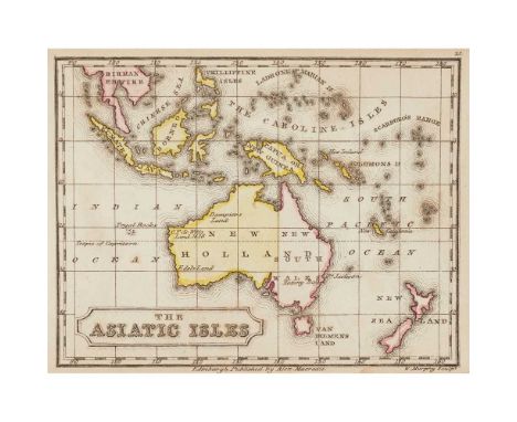
Lot 229
[Fuller, John] Narrative of a Tour through some parts of the Turkish Empire Not Published. London: printed by Richard Taylor, 1829. First edition, 8vo, [vi], 560, presentation copy inscribed 'To W. H. Hyett Esq. from the Author', large folding map, hand-coloured in outline, contemporary half calf, rebacked, map neatly strengthened at fold on verso, spotting chiefly to the mapNote: Note: A rare work. The author visited Corfu, the Morea, Athens, Smyrna, Turkey including Constantinople, the Archipelago, Egypt, Palestine, present day Syria, Cyprus, Rhodes and Zante.Provenance: From the library of the late William St Clair, FBA, FRSL.

Lot 233
Greece 19 volumes Sonnini, C.S. Voyage en Grèce et en Turquie. Paris: Buisson, 1801. Folio, atlas volume only, 6 plates, original boards, lacking the map, worn, covers detached; Leake, William M. The Topography of Athens. 1821. Oblong folio, atlas volume only, 8 plates, original boards, with paper label to upper board, spotted, spine worn;Scott, A. Grammar of the Modern Greek Language. London, 1828, 12mo, original boards, upper board detached;Comstock, John L. History of the Greek Revolution. New York, 1828. 8vo, both plates defective, with loss, lacks map, spotted, worn, cover detached; Keightley, Thomas. History of the War of Independence in Greece. Edinburgh, 1830, 2 volumes, 12mo, original cloth;Murray, John. Handbook for Travellers in Greece. London, 1854. 8vo, original cloth, slightly rubbed, ?lacking general map; Wordsworth, C. Athens and Attica. London, 1869. 8vo, plates, contemporary calf gilt;Tozer, H.F. Lectures on the Geography of Greece. 1873. 8vo, presentation copy, half calf, boards detached;Wordsworth, C. Greece, pictorial, descriptive & historical. 1882. Large 8vo, plates, original cloth, rubbed;Baikie, James. The Sea-Kings of Crete. 1910, 8vo, original cloth;Hogarth, David G. Ionia and the East. Oxford, 1909, 8vo, map, modern half morocco gilt; and 7 others; sold not subject to returnNote: Provenance: From the library of the late William St Clair, FBA, FRSL.
Lot 236
Greece 13 volumes Williams, H.W. Select Views in Greece. London, 1829. 2 volumes, large 8vo, 64 engraved plates, green morocco gilt, some dampstaining, rubbed;Hogg, Thomas Jefferson. Two hundred and Nine Days, or the Journal of a Traveller. 1827, 2 volumes in 1, red half morocco;Emerson, James. Letters from the Aegean. London, 1829. 2 volumes in 1, 1 plate, 1 folding map, original cloth, joint broken;Paul, R.B. The Antiquities of Greece. Oxford, 1835, 8vo, plates, original cloth;Vane, C.W. A Steam Voyage to Constantinople. London, 1842. 2 volumes, 8vo, 2 frontispieces and 1 plate, original pictorial cloth, some spotting, rubbed, one hinge weak;Warburton, Eliot. The Crescent and the Cross. 1851. 8th edition, 8vo, 2 plates, original cloth giltPfeiffer, Ida. A Woman's Journey round the world. London, [1852], 8vo, plates, modern quarter calf;Olin, Stephen. Greece and the Golden Horn. New York, 1854. 8vo, additional title, plates, original cloth, spotting, worn;Townshend, F.T. A Cruise in Greek Waters. London, 1870, 8vo, frontispiece, original brown cloth;Hanson, Charles H. The Land of Greece described & illustrated. 1886. Large 8vo, plates, original cloth, slightly rubbed;Diehl, Charles. Excursions in Greece. London, 1893. 8vo, illustrations, original cloth, worn;sold not subject to returnNote: Provenance: From the library of the late William St Clair, FBA, FRSL.
Lot 24
Agriculture Collection of Scottish county surveys and other treatises, 18th-19th century Columella, Lucius Junius Moderatus. Of Husbandry, London: A Millar, 1745. First edition in English, 4to, contemporary calf, contemporary calf (front board detached, crude attempted repairs to front joint) [ESTC T82174];Parkinson, Richard. The Experienced Farmer. London: for G. G. and J. Robinson, 1798. First edition, 2 volumes, 8vo, contemporary tree calf, rebacked, gilt-lettered 'Board of Agriculture 1800' on front covers, related ink-stamps to versos of title-pages [ESTC T123478: 10 copies in UK libraries];Ellis, William. The Modern Husbandman. London: T. Osborne, and M. Cooper, 1744. 4 volumes, 8vo, contemporary mottled calf, rebacked [ESTC T27820];Russell, Joseph. An Improved System of Agriculture. Kenilworth: for the author, 1840. First edition, 8vo, modern boards, half-title, 2 engraved plates;Morice, Francis. An Essay on Agriculture, and the Management of Landed Estates. Aberdeen: for the author, 1824. 8vo, uncut in original boards, half-title;Buchan-Hepburn, George. General View of the Agriculture ... of East Lothian. Edinburgh: John Moir, 1794. First edition, 4to, contemporary boards, rebacked, binding defective and several leaves loose, half-title, errata leaf, contemporary inscription 'Gilbert Burns, from a friend' on title-page (possibly Gilbert Burns, 1760-1827, brother of Robert and farmer in East Lothian) [ESTC T40588];Martin, Alexander. General View of the Agriculture in the County of Renfrew. London: C. Clarke, 1794. First edition, 4to, modern cloth, half-title, engraved plate (shaved) [ESTC T40669];Marshall, William. General View of the Agriculture of the Central Highlands of Scotland. London: T. Wright, 1794. First edition, 4to, modern wrappers, half-title, custom slipcase [ESTC T40609];Heron, Robert. General View of the ... Hebudae or Hebrides. Edinburgh: John Paterson, 1794. First edition, 4to, half-title discarded, custom slipcase [ESTC T40705];Robson, James. General View of the Agriculture in the County of Argyll, and Western Part of Inverness-Shire. London: W. Smith, 1794. First edition, 4to, disbound, retaining half-title, custom slipcase [ESTC T40596];Anderson, James. General View of the Agriculture ... of the County of Aberdeen. Edinburgh: [no publisher], 1794. First edition, 4to, contemporary marbled boards (covers detached), half-title, bookplate of Macdonald of St Martins [ESTC T40592];Fullarton, William. General View of the Agriculture of the County of Ayr. Edinburgh: John Paterson, 1793. First edition, 4to, modern card wrappers, half-title discarded [ESTC T40612];Trotter, James. General View of the Agriculture of the County West Lothian. Edinburgh: Adam Neill, 1794. First edition, 4to, half-title (repaired), disbound [ESTC T40684];Mackenzie, Sir George Steuart. A General View of the Agriculture of the Counties of Ross and Cromarty. London: Richard Phillips, 1810. First edition, 8vo, modern cloth, folding map, untrimmed;Singer, William. General View of the Agriculture ... of Dumfries. London: Sherwood, Neely, and Jones, [1812]. 8vo, uncut in original boards, rebacked, half-title, engraved folding map, 9 plates including 4 coloured aquatints of cattle, errata leaf;and 13 others, including further county surveys (John Wilson, Renfrewshire, 1812; John Smith, Argyle, 1813; David Souter, Banff, 1812, etc.), Adam Dickson, The Husbandry of the Ancients, 1788 (2 volumes, 8vo, uncut in original boards, labels renewed), and similarNote: Provenance: The Library of the late John Watson Ravenshear, with his bookplates.
Lot 244
Greece and the Mediterranean Collection of travel narratives and historical accounts in German and Scandinavian languages [Asp, Pehr Olof von]. Resa i Levanten år 1796. Öfversättning från fransyskan af M. Hasselrot. Skara: F. J. Leverentz, 1805. First edition, 8vo (17 x 10cm), contemporary half sheep, 272 pp., browning,Ukert, Friedrich August. Historisk-geografisk tafla af Grekland. Stockholm: Zacharias Haeggström, 1821. First edition in Swedish (first published in German as Gemaelde von Griechenland, 1810), 16mo (13.7 x 9cm), contemporary maroon half morocco, 6 aquatint plates;Fenger, J. Ferdinand. Om det nygraeske Folk og Sprog. Erindringer fra en Reise i Graekenland i Aare 1831. Copenhagen: C. Graebe & Son, 1832. First edition, 8vo, original printed boards, 151 pp., edges untrimmed, spotting, ink-stamp ('Nyso Bibliothek', with coronet) to title-page;Brøndsted, Peter Oluf. Reise i Graekenland i Aarene 1810-1813. Copenhagen: Samfundte til den Danske Literaturs Fremme, 1844. First edition, 2 volumes, 8vo (19 x 11.7cm), contemporary marbled half roan, lithographic portrait frontispiece, folding map, browning;[Sander, Heinrich]. Erinnerungen eines ehemaligen griechischen Offiziers. Darmstadt, L. Pabst, 1839. First edition, 8vo (17.8 x 10.8cm), contemporary red quarter morocco, bookplate of Wilhelm, Herzog zu Braunschweig, annotation by William St Clair on front free endpaper, 'From the library of Queen Frederika, with the bookplate of the Duke of Brunswick';Münch, Ernst. Die Heerzüge des christlichen Europas wider die Osmanen, und die Versuche der Griechen zur Freiheit. Basel: in der Schweighauser'schen Buchhandlung, 1822-5. First edition, parts 1-4 of 5 in 2 volumes, 8vo, contemporary boards;Schömann, Georg Friedrich. De comitiis Atheniensium. Griefswald: Ernest Moritz, 1819. First edition, 8vo, contemporary sheep, armorial device to covers in blind, bookplates (Henry Pelham), spine defective, spotting;Frommel, Carl Ludwig. Ansichten aus Griechenland. [No place, no publisher], c.1850. Oblong 4to, contemporary quarter calf, engraved title-page, 30 engraved plates each with descriptive text-leaf, bookplate (A. Pitlo);and approx. 20 others similarNote: Provenance: From the library of the late William St Clair, FBA, FRSL.
-
109198 item(s)/page