We found 109198 price guide item(s) matching your search
There are 109198 lots that match your search criteria. Subscribe now to get instant access to the full price guide service.
Click here to subscribe- List
- Grid
-
109198 item(s)/page


Lot 138
'Prospect of the Borough of Scarborough', 18th century hand coloured engraving 19cm x 30cm; early 19th century engraved map of Scarborough; four original Victorian photographic views of the North Bay Pier and a reproduction map of Yorkshire (7) Condition Report Click here for further images, condition, auction times & delivery costs


Lot 433
A Jacques Nicolas Bellin map, Carte Reduite des Mers Comprises Entre l'Asie et l'Amerique, with hand colouring, dated 1742 See illustration Condition report Report by GH This map is framed and mounted. Map does not appear to be pasted down on to a backing board (the map shows ripples and undulations which would be flattened if it had been glued down).


Lot 455
A James Wyld map, Ireland, with hand colouring, and other assorted maps (unframed) (qty) Condition report Report by GH These are genuine period maps of various dates and ages. Included in the lot are as follows: Somersetshire, by Thomas Bowen, Somersetshire from Moules English Counties, by I. Dower, Zoological map showing the distribution of the principle mammiferous animals over the globe, engraved by I. Dower, birds and reptiles by the same, Somersetshire, engraved by Figot & Co, Manchester, with hand colouring, Somersetshire, by J Pass, Somersetshire by J. Archer, Somersetshire by Robert Sayer, five other Somersetshire maps, Ireland, by James Wyld, dated 1856, with hand colouring, Scotland by the same, Great Britain and Ireland, by James Wyld, and Gambia, published by the War Office, 1912.

Lot 460
A John Speede and John Norden map, Essex, with hand colouring, a James Wyld map, City of Dublin, Castle Sheet, and other maps (unframed) (qty) Condition report Report by GH Includes and military map of Rathcoole and country south, on linen, a hand coloured map of Essex, a map of Plymouth, Stonehouse and Devonport, a linen backed map of the city of Dublin by James Wyld (Castle Sheet), a linen map of County Cork and a military map of Wiltshire and surrounding area, with some colouring in and pencil sketches around the Salisbury Plain area, this map is dated 1898. These are all period and not reproduction.


Lot 92
A collection of photographs and items related to John M Reilly, Engineer, including the construction of Stormont Parliament building and opening, First World War aviation photographs, trench maps, ephemera, postcards, autographs and items (box) Condition report Report by GH There is a trench map depicting an area of the Macedonian front in Greece, showing the capitol Kumli line, various roads, trenches and directions to Savjak, Prosenik and Barakli. Inscribed J Reilly verso. Many of the aviation photographs also appear to be from the same geographical location.


Lot 3133
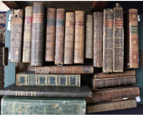
A collection of antiquarian leather bound books to include: Lewis (Samuel, & Co., publishers). 'Lewis's Atlas Comprising the Counties of Ireland',1837,calligraphic title with an engraved allegorical vignette, contents list, folding map of Ireland (torn to top left) and thirty-two (complete as list) uncoloured engraved county maps,'The History and Antiquities of the Tower of London' by John Bayley, 1830, 'A Collection of Authentic Discoveries and Entertaining Voyages round the World',1763, 'Some Account of London' by Thomas Pennant, 'An Apology for the True Christian Divinity, Quakers' by Robert Barclay, 1737, 'Captain Cook's Third and Last Voyage to the Pacific Ocean' c.1790, 'A History of the People called Quakers' by John Gough, 1789, vol.1 & vol.3, 'Journal of the Life, Gospel Labours, and Christian Experiences of that Faithful Minister of Jesus Christ' by John Woolman, printed by R. Jackson 1776, 'The Shipwreck, a Poem' by William Falconer, 1804 and others various. (1 box)


Lot 2337
Map: Speed John, Gloucestershire: contrived into thirty three severall hundreds and those againe into foure principall devisions. The Citie of Gloucester and Birstowe described with the armes of such noble men as have been dignified with ye titles of Earles and Dukes thereof, published by Thomas Bassett and Richard Chiswell, 1676, hand coloured engraved map, double sided, framed and glazed, approx. 40 cm x 50 cm


Lot 1449
Mottley (John), The History of the Life of Peter I, Emperor of Russia, second edition, J. Read, London 1740, three-volume set, iv (inclusive of errata page) + 258pp + 43 (index), iv + 280pp + 41 (index), ii + 327pp + 24 (index) + errata page, complete with vol. I: frontispiece portrait + 2 folding maps and 2 folding plates, vol. II: frontispiece portrait, vol. III: 1 folding map and 7 plates, spine with raised banding and Arabic numbering, full period calf, 8°


Lot 100
Malta. Seutter (Matthaus), Melite vulgo Malta cum vicinis Goza quae olim Gaulos et Comino insulis uti exhibetur a Nic de Fer..., published Augsberg, circa 1740, engraved map with contemporary hand colouring, orientated with south in the north, inset plan of Valetta harbour, panel of sixty-eight coats of arms to lower right and an uncoloured engraved vignette of an allegorical marine scene, short split at base of central fold, 505 x 585 mm (1)
Lot 101
Middle East. Niebuhr (Carsten), Terrae Yemen maxima pars seu Imperii Imami Principatus Kaukeban nec non ditionum Haschid u Bekil, Nehhm, Chalƒn abu Arisch et Aden tabula, circa 1775, uncoloured engraved map, old folds, closed tear strengthened on verso, 580 x 375 mm, together with, Wagner (J.C.), Die Egptische Flammseillen, circa 1686, uncoloured engraved view of the pyramids, printers folds, 265 x 335, with another two views similar, and three folding engraved views of the ruins at Persepolis, various sizes and condition (7)

Lot 104
North America. Lotter (Tobias Conrad), America Septentrionalis Concinnata juxta Observationes Dun Academiae Regalis Scientiarum et nonnullorum aliorum et juxta annotationes recentissimas per G.de L'Isle, published Augsberg, circa 1770, engraved map with contemporary hand colouring, large ornate uncoloured cartouche, slight dust soiling and staining, central fold partially split, 465 x 585 mm (1)

![*Northumberland. Speed (John), Northumberland, published John Sudbury & George Humble, [1616], hand coloured engraved map, in](https://cdn.globalauctionplatform.com/2f4aa010-bbf9-4378-adf4-a64000b7ea08/605de3d1-9fe3-447e-b6d1-7f5ff572f3ef/468x382.jpg)
![*Northumberland. Saxton (Christopher), Northumbriae Comitatus (Scotiae contiguae) nova veraw descriptio, [circa. 1579], engra](https://cdn.globalauctionplatform.com/2f4aa010-bbf9-4378-adf4-a64000b7ea08/b792048a-344b-49aa-851e-d1d3904fe3ef/468x382.jpg)
Lot 109
*Northumberland. Saxton (Christopher), Northumbriae Comitatus (Scotiae contiguae) nova veraw descriptio, [circa. 1579], engraved map with contemporary hand colouring, elaborate strapwork cartouche, with the coat of arms of Thomas Seckford, 385 x 460 mm, mounted, framed and glazed The first printed map of Northumberland. (1)


Lot 113
Persia. Haffner (Johann Christoph), Das Konigreich Persien, published Augsburg, circa 1680, uncoloured engraved map, displayed on a 'scroll' with garlands of hanging fruit and foliage, panorama of Isphahan (Tehran) below map, overall size 280 x 350 mm, together with, Merian (Matthaus), Persia sive Sophorum Regnum, circa 1690, uncoloured engraved map, occasional later underlining, 270 x 350 mm, with, Van der Aa (Pierre), Royaume de Perse..., published Leiden, circa 1710, uncoloured engraved map, old folds, 285 x 350 mm (3)
Lot 114
Railway map. London to Birmingham Railway, c.1860, very large ink manuscript and watercolour map, laid on canvas, some dust soiling, 650 x 5400 mm The section of railway shown travels through Warwickshire. It shows Nailcote Hall (now a luxery hotel) and Berkswell and Hampton stations. Hampton station was opened in 1838, it was re-named Hampton Junction in 1849 but reverted to Hampton in 1872. It was eventually closed in 1935. (1)

Lot 115
Rome. Homann (Johann Baptist), Urbis Romae Veteris ac Modernae Accurata Delineatio..., published Nuremberg, circa 1730, engraved map with contemporary hand colouring, inset map of the seven hills of Rome, panels of text and coats of arms, partial split to central fold, strengthened on verso, 495 x 585 mm (1)
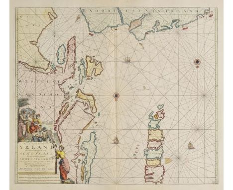
Lot 116
Sea charts. Van Keulen (Johannes), Pascaart van de Noortcust van Yrland als meede de Westcust van Schotlamd en een gedeelte van de Lewys Eylanden..., Pascaert van de Westkust van Schotlandt als mede een gedeelte van de Lewys Eylanden van St. Patricius tot Nary..., [and] A New Gradually Encreasing Compass Map of a part of the Sea coasts of England in which is contained the Coasts of Sussex Extending Eastward of Hastings to Arundel haven..., published Amsterdam circa 1680, together three engraved sea charts with contemporary outline colouring, each approximately 510 x 580 mm (3)
![*Surrey. Norden (John & Kip William), Surrey olim sedes Regnorum, [1607 - 1610], engraved map with contemporary outline colou](https://cdn.globalauctionplatform.com/2f4aa010-bbf9-4378-adf4-a64000b7ea08/4421e1b2-8541-43f9-c07c-4b1e89eb1c09/468x382.jpg)
-
109198 item(s)/page