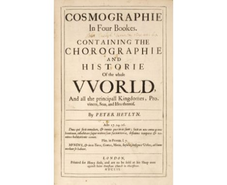

Heylyn (Peter). Cosmographie, In Four Bookes. Containing the Chorographie and Historie of the Whole World, and all the principal Kingdomes, Provinces, Seas, and Isles thereof, 1st edition, 2 volumes, London: Henry Seile, 1652, additional engraved title to first volume (small hole to upper blank margin, dust-soiled, lined to verso), initial titles to both volumes with signature of "John Evelyn [Junior] Durate &c Virg: aen: 1.1", four double-page engraved maps (Europe, Asia, Africa, and Americas), each map cropped to edges with some loss, first volume with ink stain to fore-edge blank margins of leaves 2Q1 & 2Q2 and closed tear to 2Q6, lower outer blank corner of 2S4 torn away, front free endpapers with manuscript press mark D6:8, front pastedowns with armorial bookplate of Sir Frederick Evelyn Bart. and 20th century John Evelyn library 'J.E' bookplate, attractive contemporary speckled calf, with elaborate gilt decorated spines, upper joint of first volume cracked at head & foot, folioQTY: (2)NOTE:Provenance: John Evelyn, junior (1655-1699), son of John Evelyn, writer, diarist & gardener, 1620-1706; The Evelyn Library, Christie's December 1, 1977, lot 740, where purchased by Desmond Burgess for £200.Wing H1689; ESTC R5447.Books 1-3, the two parts of book 4, and the Appendix each have separate dated title page; register attempts to be continuous. Pagination is separate except for book 4, part 2, which is continuous with part 1.
We found 109198 price guide item(s) matching your search
There are 109198 lots that match your search criteria. Subscribe now to get instant access to the full price guide service.
Click here to subscribe- List
- Grid
-
109198 item(s)/page

Xenophon. Xenoph?ntos Kurou paideias biblia okt?. Xenophontis de Cyri institutione libri octo. Graeca recognovit, cum codice MS. Oxoniensi & omnibus fere? libris Editis contulit, plurimis in locis emendavit, Versionem Latinam reformavit, Observationibus suis, Tabulaque Geographica auxit & illustravit ; Notas H. Stephani, Leunclavii, AE. Porti & Mureti recensitas & castigatas, Variantium Lectionum delectum, Indicesque necessarios adjunxit Thomas Hutchinson A.M., London: Typis J. Bettenham, impensis B. Barker & A. Bettesworth, 1730, engraved map frontispiece, first line of title in Greek characters, title page in red & black, Greek and Latin text throughout, front free endpaper with contemporary inscription Jon. Hodgetts Eins liber Anno Domini 1744 April the 28th' and bookplate of J.H. Hodgetts Foley to upper pastedown, contemporary calf, joints cracked, worn to spine and without title label, board corners worn and showing, 8voQTY: (1)NOTE:John Hodgetts-Foley (17 July 1797 – 13 November 1861) of Prestwood House (then in Kingswinford, and now in Kinver) in Staffordshire. He was the second son of the Hon. Edward Foley of Stoke Edith, Herefordshire and Eliza Maria Foley Hodgetts. He inherited the Prestwood estate from his mother, whose mother Eliza Foley was a descendant of the ironmaster Philip Foley (1648-1716). John represented the borough of Droitwich in Parliament from 1822 to 1835 as a Whig and East Worcestershire from 1847 to 1861 (initially as a Whig and from 1859 as a Liberal). He married Charlotte Margaret Gage, daughter of John Gage and Mary Milbanke (granddaughter of General Thomas Gage and Margaret Kemble), on 20 October 1825 and had one son, Henry John Wentworth Hodgetts-Foley.
A set of seven maps of The Lakeland Fells, based on material contained in the Pictorial Guide to The Lakeland Fells by A Wainwright, titles "The Southern Fells", "The Western Fells", "The Eastern Fells", "Eastern Fells", "The Far Eastern Fells", "The Central Fells", "The Northern Fells", "The North Western Fells". Each map is an amalgamation of all his hand drawn pictorial maps for each of his geographical districts. All unframed, varying sizes. Provenance - These first edition maps were produced by Chop McKean Limited for Michael Joseph Limited throughout the mid to late 1990's. This collection then passed to Derek Walker a well known book wholesaler who was responsible for much of the success of the book sales for the Westmorland Gazette, this collection was then obtained by the present owner.


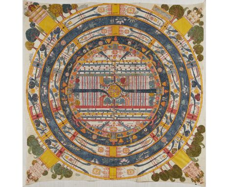
ADHAIDVIPA PATA DE MADYALOKAGUJARAT, XVIIIE SIÈCLEDistemper on cloth. 119 x 117 cm (46 7/8 x 46 in.), irregular Footnotes:AN ADHAIDVIPA PATA OF MADHYALOKA GUJARAT, 18TH CENTURY古吉拉特邦 十八世紀 耆那教宇宙學中觀世界圖 Published: Jan van Alphen, et al., Steps to Liberation: 2500 Years of Jain Art and Religion, Antwerp, 2000, p. 177, no. 42. Exhibited: Steps to Liberation: 2,500 Years of Jain Art and Religion, Etnografisch Museum Antwerpen, 26 May - 15 October 2000. Provenance: With Claude de Marteau, Brussels, by 1980s Discussing this Jain cosmological map, which Claude de Marteau displayed prominently in his dining room, van Alphen notes, 'This extremely detailed and richly coloured representation of Adhaidvipa - the 'two and a half' continents - is most probably based on an early seventeenth-century model. However, the clothes worn by the various figures, the architectural details of the palaces and also the aquatic figures point to the eighteenth century. The painting shows some unusual features, the extra ring between the central continent, Jambudvipa, and the surrounding salt ocean, Lavanoda, for instance. It is abundantly filled with flowers and trees in a purely decorative style. Great care has been taken in the painting of the figures in the oceans, one of the few areas in which the artist enjoyed a measure of freedom in the otherwise strictly defined representation of the madhyaloka, 'the middle world'. A great many inscriptions are included within the area of the 'two and a half' continents, which are more usually found around its circumference.'For further information on this lot please visit Bonhams.com


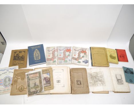
17x 18th, 19th and early 20th Century books. Including; The Modern Traveller; Russia (pub. Duncan 1825) with foldout map. Travels in Italy by M. Valery (pub. Baudry's European Library 1852). A Summary of Roman Law by Dr. Taylor (pub. T. Payne 1772). Mr. Midshipman Easy. Fairy Tales by Andersen (1908). Trafalgar (1905). Life of Samuel Johnson by Boswell - 3rd vol. (pub. 1799). The Biographic Treasury (in 5 vols - pub 1870). Plus a number of other odd volumes from various works. QGC-GC. £30-50


CORNWALL ENGRAVINGS, PHOTOGRAPHS ETC. The Cornwall pages & Morden map of Cornwall removed from Camdens Britannia 1695, various 19th century Cornwall views & commercial engravings & cabinet photographs etc. Please note that all items in this auction are previously owned & are offered on behalf of a private vendor. If detail on condition is required on any lot(s) PLEASE ASK FOR A CONDITION REPORT BEFORE BIDDING. The absence of a condition report does not imply the lot is perfect.WE CAN SHIP THIS LOT, but NOT if part of a large, multiple lots purchase.

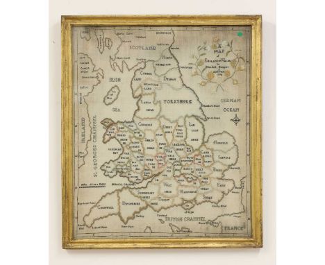
A George III map sampler of England and Wales,'by Elisabeth Kempton, aged 7 years, 1794', worked in polychrome silks on linen depicting England and Wales divided into counties,53 x 44cm, framed and glazedProvenance: the Pleydell-Bouverie Family, thence by descent.Map samplers, especially those of the British Isles, were popular amongst English schoolgirls from the end of the 18th century to the first few decades of the 19th century.Frame size 59 x 50cm. Some light browning and fading to colours. Loss to stitches in the border, particularly the upper lefthand corner. One visible hole in the upper border in the upper right quadrant. Not inspected out of frame.
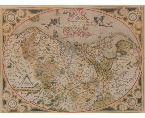
Abraham Ortelius,Descriptio Germaniae Inferioris,hand-coloured map,37x50cm.From Ortelius' Theatrum Orbis Terrarum, the first modern atlas of the world.Condition report:Good condition, not laid down, colours fairly good, mounted very close to the plate mark so unsure of margins, modern frame and under glass.


A Gilbert, Haddon Hall, signed and inscribed verso, oil on canvas, as found, 20 x 26cm; Benjamin Cole, Cripplegate Ward with it's divisions, St Luke's Hospital, hand-coloured map, 37cm x 23cm; Michael Chaplin, Two Dutch Barges, signed limited etching with aquatint, numbered 36/200; together with other prints, engravings, etc.
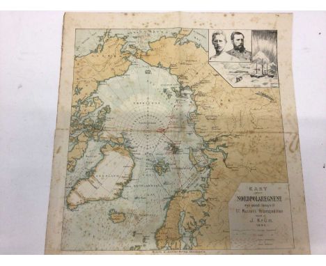
A group of ephemera including 1896 Illustrated Map "Dr. Nansen's Polar Expedition" by J Krum, 1916 War Saving Certificate, 1881/82 New Zealand Consolidated Stock- £4 per share to the value of £7,000 and £10,012 with associated letter, 1888 Paper-lace Valentine and Love Letter, Silk Postcard Card, Special Operations Lincheon Savoy Hotel I960 programme and list of speakers, fornt cover designed by Jean Cocteau and other items.


![[Mostyn John Armstrong]: 'The History and Antiquities of the County of Norfolk', 1781, vols 3-7, comprising vol 3 Hundreds of](https://cdn.globalauctionplatform.com/54f58e03-698c-4168-8ce7-aead010dd9fc/beba6e38-9009-4083-8d9e-aead0118dda1/468x382.jpg)
[Mostyn John Armstrong]: 'The History and Antiquities of the County of Norfolk', 1781, vols 3-7, comprising vol 3 Hundreds of North & South Erpingham, Eynsford, 10 engraved plates including Wolterton Hall, Barningham Hall, Cromer, Felbrigg Hall, Hanworth Hall, Gunton Hall, Baconsthorpe Hall, Heydon Hall folding plate after a drawing by Humphry Repton, etc; vol 4 Hundreds of East & West Flegg, Forehoe, 5 engraved plates including Great Yarmouth, Wymondham Abbey, Cossey Hall, Easton Lodge etc; vol 5 Freebridge Lynn, Freebridge Marshland and Gallow, folding map of fens + 7 engraved plates including Houghton Hall, Castle-Acre Castle, Castle-Acre Monastery, Rising Castle, Lynn Regis (King's Lynn), Middleton Castle, portrait of Robert Walpole etc; vol 6 North & South Greenhoe, Grimshoe & Guiltcross, 6 engraved plates including Binham Priory, Walsingham Abbey, South view Walsingham Abbey, portrait Sir Henry Spelman, Holham Hall folding plate North & South elevation, Hillborowe Park House etc; vol 7 Happing, Henstead, Holt, Humbleyard and Loddon, engraved plates Bixley Hall, Venta Icenorum, Melton Constable Hall, Ditchingham Hall, uniform contemporary calf gilt (very worn); together with Edward Preston Willins: 'Some of the Old Halls and Manor Houses in the County of Norfolk', 1890, limited edition (numbered 140), 50 plates, folio, original cloth gilt; plus Charles Green: 'The History, Antiquities, & Geology, of Bacton, in Norfolk', Norwich, Josiah Fletcher, 1842, etched frontis of Bromholme Priory, double page geological plate, double page engraved plate of skeletal remains + 1 other engraved plate of skeleton, contemporary cloth worn; plus catalogues of contents sale of "The Hall, Shipdham, Norfolk, 1921", and "West Mill, Horringer Road, Bury St Edmunds, 1945", each original cloth backed covers (9)

Francis Blomefield & Charles Parkin: 'An Essay Towards a Topographical History of the County of Norfolk', London, William Miller, 1805-1810, 11 volumes, mezzotint portrait frontis plus 3 folding engraved maps/plans (Norwich, King's Lynn, and Map of Marshland that is often lacking) plus 33 engraved plates (many folding) plus 14 pedigrees on 15 folding sheets as called for, half titles, uniform contemporary diced half calf gilt (worn), upper board of volume I and lower boards of volume IX & XI detached (but present), armorial bookplates of Lieutenant Colonel Frederick Keppel (1762-1830) of East Lexham, Norfolk, to front pastedowns, and bookplates of Julia Augusta Kendall (1852?-1936) to marbled endpapers. A complete set in a contemporary binding of Blomefield's comprehensive history of the county of Norfolk, widely considered to be detailed, reliable and comparable with the best county histories of the period (11)

(Crimean War, Illustrated London News), two bound volumes of 'The Illustrated London News', comprising a composite bound volume with issues dating from April 7th-September 29th 1855, much Crimean War content and illustrations, several full page engraved illustrations, including funeral of Lord Raglan before Sebastopol and Kazatch Bay; double page engraving 'The Fall of Sebastopol - capture of the Malakoff Tower), plus many other Crimean War engraved illustrations etc; other content/illustrations including Napoleon; sailing of the Baltic Fleet; double page engraving of fireworks at Versailles; eruption of Vesuvius, etc, folio, original publisher's pictorial cloth gilt (very worn); together with I.L.N. volume 28, January-June 1856, large engraved folding map of the Crimea and adjacent coasts (approx. 57x80cm), and verso engraved illustration 'The Allied Commanders in Crimea', large closed tear, some wear at folds etc; plus much other content Crimean War and Crimean War peace celebrations, engraved ills. including fireworks in Victoria Park, illuminations at the National Gallery and The Strand, fireworks in Phoenix Park, Dublin etc; other content/ills. including Falkland Islands; Nassau, Bahamas; Santhal Insurrection; Valparaiso & Santiago Railway, etc, folio, old cloth very worn, large piece of backstrip detached (2)

(Classical Civilizations, History, Antiquarian), a collection of 12 volumes, including Thomas More: 'Utopia : containing an impartial history of the manners, customs, polity, government, &c. of that island', translated Gilbert Burnet, Oxford, J. Newbery, 1751, lacks portrait frontis, xx,168,[8]pp, 12mo, contemporary diced calf gilt, later rebacked; [Torquato Tasso]: 'Godfrey of Bulloigne : or the recovery of Jerusalem. Done into English heroical verse, by Edward Fairfax, gent. Together with the life of the said Godfrey. Licensed to be Re-Printed. Sept. 18. 1686. Ro. L'Estrange.', Dublin, A. Rhames, 1726, title page laid down with some small part losses, prelims i-xii repaired/restored, with small part losses and leaves laminated, worm damage affecting lower margin only of other leaves, rebound calf gilt; 'The Works of Flavius Josephus', translated William Whiston, Edinburgh, Allman, 1826, 4 volumes, engraved folding map to volume I, uniform contemporary calf gilt (worn); David Hume: 'The History of England From the Invasion of Julius Caesar to the Revolution in 1688...and a Further Continuation to the Present Period...By Hewson Clarke', L, Richard Evans, 1813-1815, 3 volumes, engraved frontises, engraved title pages plus numerous engraved plates, folding maps etc, thick 4to, uniform contemporary diced calf gilt, spines gilt in compartments (rubbed); Xenophon: 'Anabasis Kyrou Xenophontos. Or, The expedition of Cyrus into Persia, and the retreat of the ten thousand Greeks', translated N.S. Smith, L, Longman, 1824, engraved folding map frontis, old half calf (worn), top board detached but present; Charles Rollin: 'De La Maniere D'Enseigner Et D'Etudier Les Belles-Lettres, Par raport a` l'esprit et au coeur', Paris, Estienne, 1740, 2 volumes, 4to, uniform contemporary calf, spines gilt in compartments (12)
![(The Philosophical Transactions [of The Royal Society]), Henry Jones, 2 titles: 'The Philosophical Transactions. Vol IV. Cont](https://cdn.globalauctionplatform.com/54f58e03-698c-4168-8ce7-aead010dd9fc/918148d5-1dca-4231-8421-aead01193953/468x382.jpg)
(The Philosophical Transactions [of The Royal Society]), Henry Jones, 2 titles: 'The Philosophical Transactions. Vol IV. Containing Part I. The Mathematical Papers. Part II. The Physiological Papers', London, J. & J. Knapton et al, 1731, 2nd edition, 2 parts in 1 vol, [23],476,326,[8]pp, part I fourteen engraved folding plates as called for, part II five engraved folding plates as called for; '...Vol V. Containing Part I. The Anatomical and Medical Papers. Part II. The Philological and Miscellaneous Papers.', L, J & J Knapton et al, 1731, 2nd edition, 2 parts in 1 volume, [8],435,268,[24]pp, part I seventeen engraved folding plates as called for, elephant, opossum and others animal anatomy. part II twelve engraved folding plates, maps, tables as called for, including an early copy of Eusebio Francisco Kino's famous map of California, first published in 1702. Kino's map was the first to show California as a peninsula and not an island, as had previously been suspected; John Martin: '...Vol VIII. Part II. Containing the Physiological Papers', London, W. Innys et al, 1747, part II only, [3],378-847pp, 12 engraved folding plates + large folding table as called for; uniform contemporary calf gilt worn; plus an a/f very worn and soiled copy of 1732 4th edition by John Lowthorp & Henry Jones, vol I containing all the Mathematical Papers, separate title page dated 1731, 620pp, 7 engraved folding plates/maps, many leaves and plates a/f very worn and soiled, some plates ok including folding map/chart of France showing meridian and parallel of Paris, etc, old calf gilt very worn and soiled, lacks backstrip (4)

A small collection of 19th Century literature etc, including Harriet Beecher Stowe: 'Uncle Tom's Cabin', London, Routledge, 1852, 3rd edition, added engraved title page + 40 engraved plates as called for, a very early illustrated edition, contemporary half calf gilt, all edges gilt, together with 'The Key to Uncle Tom's Cabin', L, Clarke, Beeton & Co, [nd, circa mid to late C19th], old half calf gilt, all edges gilt; The Rev. Isaac Taylor: 'Scenes in Africa, for the Amusement and Instruction of Little Tarry-at-Home Travellers', L, Harris & Son, 1821, 2nd edition, engraved hand coloured folding map frontis, plus 84 engraved hand coloured views on 28 full page plates, 12mo, original calf backed pictorial paper covered boards (rubbed); Arthur Sketchley: 'Mrs Brown's visit to the Paris Exhibition', L, Routledge, [nd, circa mid to late C19th], original "yellowback" pictorial printed paper covered boards (lacks backstrip); [A. Andersen]: 'A Tour in Zealand, in the Year 1802, with an Historical Sketch of the Battle of Copenhagen', L, Baldwin, 1805, 2nd edition, engraved folding map as called for, contemporary paper covered boards; plus 1 other similar (6)

Cervantes: 'The Ingenious Gentleman Don Quixote of La Mancha', L, A & C Black, 1895, new edition, 4 volumes, translated Edward Henry Watts, together with the 5th biographic volume by him 'Miguel de Cervantes His Life and Work', A & C Black, 1895, port frontis + map, uniform original red cloth gilt, top edges gilt, others uncut (5)

(Thailand), Sir John Bowring: 'The Kingdom and People of Siam; with a Narrative of the Mission to that Country 1855.', London, John W. Parker, 1857, 1st edition, 2 volumes, the copy of Sir John Bowring, both volumes inscribed by him on half title "Lady Bowring, from her very affectionate J.B. HK 9/5/57". Folding map, 3 folding facsimile plates (Facs of King's Autograph plates with some wear/repairs, Specimen of Ancient Siamese Inscription folding plate with two neat repairs verso), plus 15 mainly chromolitho and engraved uncoloured plates as called for, including engraved portrait frontis to vol 2 depicting Bowring, plus chromolitho costume plates, views etc, rebound quarter calf gilt, vol I with some reinforcement between title page and frontis, vol II with similar between list of illustrations and leaf B. Sir John Bowring KCB FRS FRGS (1792 -1872) was an English political economist, traveller, writer, literary translator, polyglot and the fourth Governor of Hong Kong, a role in which he was extremely industrious and reformist, though in which he became embroiled in numerous conflicts, disputes and struggles. A Qing-sponsored campaign of civil disruption, threatening the very survival of the British administration, culminated in the arsenic poisoning incident of 15 January 1857 in which 10 pounds of arsenic was mixed in the flour of the colony's principal bakery, poisoning many hundreds, killing Bowring's wife and debilitating him for at least a year. In 1855, during a diplomatic visit to Siam, In 1855, he experienced a reception in Siam where he was welcomed like foreign royalty, showered with pomp (including a 21-gun salute), and his determination to forge a trade accord was met with the open-minded and intelligent interest of King Mongkut. There was much cordiality and mutual high regard between Mongkut and Bowring, this culminated in Bowring's 1867 appointment as Siam's ambassador to the courts of Europe. Provenance: from the estate of Sir John Bowring, then by descent (2)

Albert F. Calvert: 'The Exploration of Australia', London, George Philip & Son, 1895, 1st edition, 2 volumes, volume I (covering period to 1843), portrait frontis, large folding coloured map of Australia (with some tears/repairs verso) + 16 plates as called for; volume II (covering period 1844-1896), large coloured folding map of Australia as called for, ex Repton School library, Repton armorial bookplates to front pastedowns plus one or two inkstamps to each volume, uniform original cream and blue cloth gilt, top edges gilt. Ferguson 7821. Early exploration of the Australian continent often sourced from the original journals. Includes the explorations of Flinders, Captain Charles Sturt, Sir George Grey, and Edward John Eyre. (2)

Ernest H. Shackleton: 'South. The Story of Shackleton's Last Expedition 1914-1917', London, William Heinemann, 1919, 1st edition, colour frontis of the Endurance, 5 maps (of which 1 large folding map at end showing Voyage of Endurance), 87 photographic plates (of which 1 double page panorama of South Georgia) + 2 sketch plans in text as called for, some toning to text block as usual, original dark blue cloth (slightly bumped & worn) lettered in silver to spine, front cover with illustration of the Endurance blocked in silver. Probably the most evocative narrative of the Heroic Age of Antarctic exploration, telling of the survival of Shackleton and his crew under the most extreme circumstances.

Henry Morton Stanley: 'In Darkest Africa: or, The Quest , Rescue, and Retreat of Emin, Governor of Equatoria', London, Sampson Low, 1890, 1st edition, 2 volumes, 4 maps (of which 3 folding) + 38 plates and folding table as called for, original pictorial cloth gilt (slightly worn); R. G. Cumming: 'Five Years of a Hunter's Life in the Far Interior of South Africa', London, John Murray, 1851, 3rd edition, 2 engraved frontispieces, 2 added engraved title pages + 12 plates & map at end of volume I, original pictorial cloth gilt (worn). 'One of the classics of African big game hunting and exploration that recounts the seemingly limitless herds of game in the region of Cumming's era and a necessary title in the big game library.' - Czech. Czech p43; Mendelssohn I, 398-9 (4)

James Barclay: 'Barclay's Complete and Universal English Dictionary, with which is Incorporated, a Complete Modern Gazetteer and Atlas of Maps...brought down to the present year 1811...', Leeds, Davies & Booth, [1811], added engraved title page, engraved map "The New World or Western Hemisphere" at front (attached to front pastedown with two adhesive tabs), plus 11 engraved maps, mainly hand coloured in outline, including Africa, South America, China, England & Wales, Hindoostan with Island of Ceylon, Maldivas etc, Ireland, Scotland, etc, a/f, leaves with heavy mainly marginal toning/browning, small number of leaves with some small tears and small part losses, maps with toning/foxing but else generally ok, thick 4to, contemporary half calf gilt (rubbed/worn)

(Mesopotamia, Babylonia, Middle East, present day Iraq, Syria) Leonard William King: 'A History of Sumer and Akkad. An account of the early races of Babylonia from prehistoric times to the foundation of the Babylonian monarchy', London, Chatto & Windus, 1910, 1st edition, frontis + 33 full page plates, 12 maps and plans (of which 1 folding), plus numerous ills. in text as called for, ex Repton School Library inkstamp to title page, two small ref. numbers to front pastedown/FFEP, original cloth gilt, top edge gilt; Edmund Candler: 'The Long Road to Baghdad', London, Cassell, 1919, 1st edition, 2 volumes, 19 maps and plans (2 folding) + 16 full page plates as called for, uniform original pictorial cloth gilt; Eleanor Franklin Egan: 'The War in the Cradle of the World', L, H & S, [1918], 1st edition, portrait frontis + 24 photographic ills. on 15 full page plates, original cloth (spine browned), mounted illustration to front cover; [Ibn al-Muqaffa]: 'Kalila et Dimna. Fables Indiennes traduites du Persian en Arabe', Mossoul [Mosul], Imp. des Peres Dominicains, 1883, 3rd edition, contemporary half cloth gilt; Marquess Curzon of Kedleston: 'Tales of Travel', L, H & S, 1923, port frontis + 26 plates (including large folding plate 'Map of Afghanistan, prepared by Amir Abdur Rahman Khan'), content includes Afghanistan, Iran, Kuwait etc, original cloth gilt (6)

(Greece), F.C.H.L. Pouqueville: 'Travels in Southern Epirus, Acarnania, Aetolia, Attica, and Peloponesus, or the Morea, &c. &c. in the Years 1814-1816', London, Sir Richard Phillips, 1822, engraved folding map + 1 engraved plate as called for, 128pp, modern rebound cloth, together with 14 other titles realting to Greece, including Kevin Andrews: 'The Flight of Ikaros', 1959, 1st edition in d/w, Mahaffy: 'Greek Pictures', RTS, 1890, original pictorial cloth, 'Architecture Néoclassique en Grèce', Athens, 1967, photographic plates throughout, original pictorial cloth, Patrick Leigh Fermor: 'Mani. Travels in the Southern Peloponnese', J. Murray & Book Society, 1958, orig. cloth gilt, plus others Mistra, Lesbos, Kythera, etc (15)
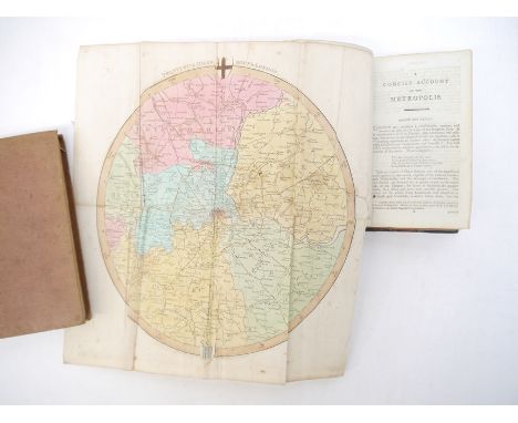
'Ambulator: or, a pocket companion in a tour round London, within the circuit of twenty five miles: describing whatever is most remarkable for antiquity, grandeur, elegance, or rural beauty...', London, J. Scatcherd, 1796, 8th edition, folding hand coloured engraved map of London & environs (some repairs verso), 12mo, old half calf, marbled paper covered boards, gilt lettered to spine "Kortenhoff Library", bookplate to front pastedown "Kortenhoff, Par Riga, Station Romescaln, Livonie, Russie", and inscription to FFEP "présenté a Lady Sackville...8. Juillet 1878"; together with an early 19th Century Paris guide book 'Paris im Jahre 1836', Stuttgart & Augsburg, 1836, large engraved folding map of Paris at end, 305,[1]pp, original cloth gilt (2)

(Gloucestershire). John Speed: 'Glocestershire contrived into thirty thre severall hundreds & those againe into foure principall devisions. The citie of Glocester & Bristowe discribed with the armes of such noble men as have bene dignified with ye titlles of Earles & Dukes therof', engraved hand coloured map, circa 1611 or later, John Sudbury and George Humble, inset town plans of Gloucester and Bristol, some wear/repairs near centrefold, approx 38 x 51cm, framed and glazed, whole approx 52 x 63cm


Nathaniel Kent: 'General View of the Agriculture of the County of Norfolk : with observations on the means of its improvement : Drawn up for the consideration of the Board of Agriculture and Internal Improvement', Norwich, Crouse, stevenson & Matchett, London, G. Nicol, 1796, engraved folding map + 3 engraved plates (of which one double page) as called for, xvi,236,[1]pp; bound together with John Boys: 'A General view of the agriculture of the county of Kent; with observations on the means of its improvement.', L, G. Nicol, 1796, engraved folding hand coloured map of Kent + 1 engraved plate + folding table, xiv,206,[1]pp, contemporary half calf gilt, marbled paper covered boards. A scarce compilation of two works re agriculture of Norfolk & Kent
William Marshall: 'The Rural Economy of Norfolk: Comprising the Management of Landed Estates, and the Present Practice of Husbandry in that County', London, T. Cadell, 1787, 1st edition, 2 volumes, engraved folding map as called for (''East Norfolk'' & ''Sketch of the County'' on one single folding sheet), contemporary half calf gilt, red leather gilt title labels to spines, marbled paper covered boards. An excellent first edition set of an important work (2)

Nathaniel Kent: 'General View of the Agriculture of the County of Norfolk : with observations on the means of its improvement : Drawn up for the consideration of the Board of Agriculture and Internal Improvement', London, G. Nicol, 1813, engraved folding map + 3 engraved plates as called for (Norfolk plough; Norfolk ram; Norfolk & Berkshire Wagons (folding)), xvi,236,[1]pp, contemporary half calf gilt. Scarce

Small collection of Norfolk & Suffolk interest titles, including Thomas Kitson Cromwell: 'Excursions in the County of Norfolk', London, Longman et al, 1818-1819, 2 volumes, folding map of Norfolk, folding plan of Norwich, two added engraved title pages + 94 engraved plates, contemporary half calf gilt, spines gilt in compartments; Charles Green: 'The History, Antiquities, & Geology, of Bacton, in Norfolk', Norwich, Josiah Fletcher, 1842, etched frontis of Bromholme Priory, double page geological plate, double page engraved plate of skeletal remains + 1 other engraved plate of skeleton, contemporary cloth worn; Rev. Arthur Brown, Rector of Catfield, Norfolk: 'The Knight of Dilham, a Story of the Lollards', Norwich, Henry Stacy, 1870, 114pp, 2 copies, each original wraps, lacking top wrap, plus another copy of the same work published London, SW Partridge & Co, c.1888, colour frontis, original pictorial cloth gilt; plus four White's Directories of Norfolk, 1836, a/f, joints split, leaves loose, leather binding worn; 1845, original calf binding very worn; 1854, inner joints weak, original calf; 1864, boards loose, lacks backstrip; plus 'White's 1844 Suffolk Directory', 1970 facsimile re-issue, orig. cloth gilt, dust wrapper (11)

'Norfolk, Divided into Hundreds and the Parliamentary Divisions', engraved folding map, published William Darton & Son, London, circa early 1800s, hand coloured in outline, engraved vignette of Norwich Cathedral, dissected and backed onto linen, 37.5x46cm, folding into original cloth gilt binding (crudely reinforced with tape to spine)


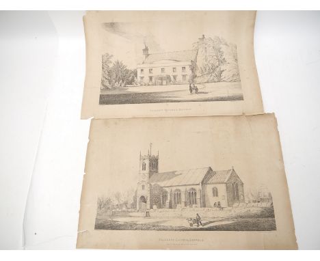
A pair of local interest 19th Century lithographs of Palgrave Rectory, and Palgrave Church, both W. Browne lith, Norwich, both approx 39 x 56cm, both with closed tears and chips; together with four early 20th Century Suffolk Ordnance Survey map sheets including Eye, Aspall, Southolt etc (6)
A collection of Norfolk & Suffolk interest titles, including Thomas Kitson Cromwell: 'Excursions in the County of Suffolk', London, Longman, 1818-1819, large paper edition, 2 volumes, 2 engraved folding maps/plans, added engraved title pages + 96 engraved plates as called for, original printed paper covered boards (very worn), boards detached but present, some leaves loose; William Taylor: 'The Antiquities of King's Lynn. Norfolk', Lynn, J. Thew, 1844, 30 engraved plates as called for, contemporary cloth very worn and soiled, crudely rebacked retaining majority of backstrip; Northcote: 'Notes on the History of Monk's Eleigh', Ipswich, 1930, original pictorial cloth; Jay: 'The First Parish Register of St. George of Tombland, Norwich', Norwich, Agas. H. Goose, 1891, published by subscription, 98 copies only (this unnumbered out of series), portrait of Mr GB Jay, map & arms supplied in facsimile, original boards, later rebacked; plus three 'Snapdragon' Norwich Hospitals' annuals 1933, 1937, 1938, each original pictorial wraps; G.C. Davies: 'The Handbook to the Rivers and Broads of Norfolk & Suffolk', c.1882, 2nd edition, large folding map in rear pocket, original pictorial boards; plus several others similar

![Abraham Ortelius - Scotland double page engraved map from Ortelius's Theatre de L'Univers, 46 x 56.5cm [c1598], not laid down](https://cdn.globalauctionplatform.com/978c7723-6f8f-4526-9fd5-aea700ff700e/f8ded97c-6325-4ca6-8d07-aea701068535/468x382.jpg)
![Joan Blaeu - Hebrides double page engraved map from Blaeu's Atlas of Scotland, hand coloured, 48.5 x 58.5cm [c1654], repaired](https://cdn.globalauctionplatform.com/978c7723-6f8f-4526-9fd5-aea700ff700e/fe10ed1e-b7fb-40b4-8c53-aea70106884c/468x382.jpg)


-
109198 item(s)/page