We found 109182 price guide item(s) matching your search
There are 109182 lots that match your search criteria. Subscribe now to get instant access to the full price guide service.
Click here to subscribe- List
- Grid
-
109182 item(s)/page


![Saxton (Christopher) Westmorlandiae Comitatus [Cumbria], engraved map by William Kip with early hand colour for Camden's Brit](https://cdn.globalauctionplatform.com/150bc69f-33aa-4c06-a211-a73d00eeff4c/022ff038-0bac-47bf-f371-4235947458bb/468x382.jpg)
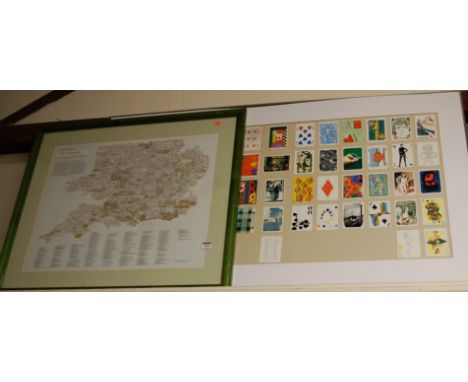
Lot 1046
Saxton (Christopher) Westmorlandiae Comitatus [Cumbria], engraved map by William Kip with early hand colour for Camden's Britannia [1637], framed and glazed [with] Wainwright (A.) Wharton Hall, [1975], original printing plate for 'Westmorland Heritage', displayed alongside a printed impression on paper, the two mounted in one frame (2)
![Two framed maps: A Map of Buckinghamshire from the latest Authorities [1789], hand-coloured engraved map by J. Cary after E.](https://cdn.globalauctionplatform.com/150bc69f-33aa-4c06-a211-a73d00eeff4c/40a91a3e-e2c6-4048-f323-b4c09c2cc5ac/468x382.jpg)


Lot 124
A good lot to include a large framed picture of Mohammed Ali with the Beatles mounted and framed under glass image size 67 cm x 44 cm, a framed picture of a lakeside scene, a framed map of Cheshire, a framed picture to commemorate the 90th birthday of Her Majesty Queen Elizabeth The Queen Mother and Her Majesty's Service Appointments with the Commonwealth Armed Forces 4th August 1990, a framed collection of Wills cigarette cards framed under glass depicting air raid precautions 1938 and a collection of Dads Army cards from Primrose Confectionery depicting scenes from the show framed under glass


![Saxton (Christopher) & Speed (John) The Kingdome of England,1610 [c1611], Sudbury and Humble, hand-coloured map, 383mm x 508m](https://cdn.globalauctionplatform.com/0742efd8-7389-4e57-b0e8-a74600ebc0bc/2e193a78-d225-4d8f-ac1b-a74601157758/468x382.jpg)


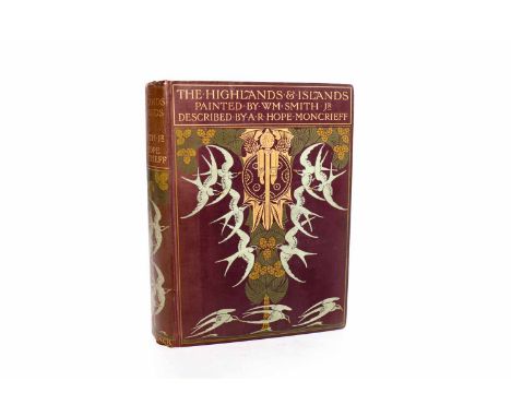
Lot 1034
HOPE MONCREIFF, A.R., THE HIGHLAND'S & ISLANDSpainted by Wm. Smith Jr, A.&C. Black, London, 1906, first edition, hardcover, the cover and spine with art nouveau design of birds, tree and gilt shield and thistle motif, 232 pages, with 40 illustrated plates and fold-out map, also has note attached inside from the sender, Alexander Gardner, and signed by the owner, dated 1906


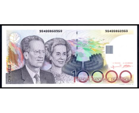
Lot 101
Belgium NBBB-110 P 146 Banque Nationale de Belgique10000 Francs (1992-97). Portrait of King King Baudouin I and Queen Fabiola at left aerial map as underprint at center on front. Signatures Bertholomé - Verplaetse. Flora and greenhouses at Laeken (royal residence) at center on back. # 90400860960. PCGS 64 PPQ Very Choice UNC
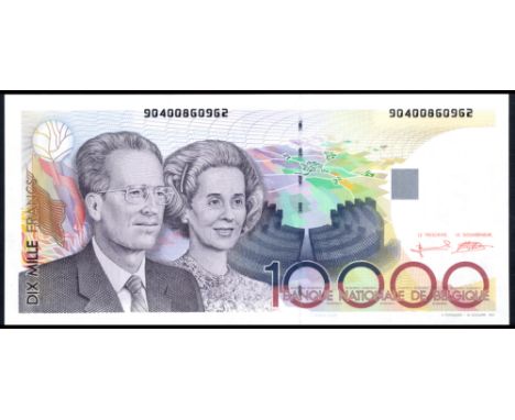
Lot 102
Belgium NBBB-110 P 146 Banque Nationale de Belgique10000 Francs (1992-97). Portrait of King King Baudouin I and Queen Fabiola at left aerial map as underprint at center on front. Signatures Bertholomé - Verplaetse. Flora and greenhouses at Laeken (royal residence) at center on back. # 90400860962. PCGS 65 PPQ Gem UNC
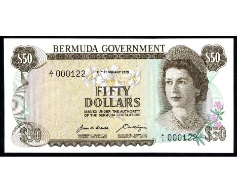
Lot 132
Bermuda P 27a Linzmayer B128a Bermuda Government 50 Dollars 6 February 1970 LOW SERIAL NUMBER. Easter Lilly's at upper center portrait of Queen Elizabeth II at right on front. Signatures Sharpe - Kempe. Gibbs Hill Lighthouse in Southampton Parish at left map of Bermuda at upper right Coat of arms of Bermuda at lower center right on back. # A/1 000122. PCGS 66 PPQ Gem UNC
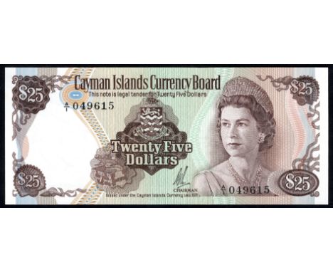
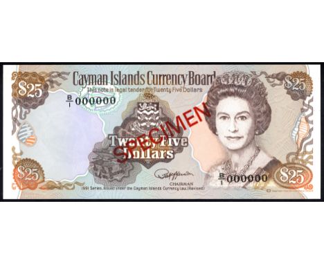
Lot 206
Cayman Islands P 14s Linzmayer B114as Cayman Islands Currency Board 25 Dollars1991 SPECIMEN. Coat of arms of the Cayman Islands at center portrait of Queen Elizabeth II at right on front. Signature Jefferson. Coral at left map at center on back. Diagonal red overprint SPECIMEN on front and back. # B/1 000000. UNC
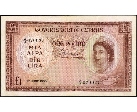
Lot 258
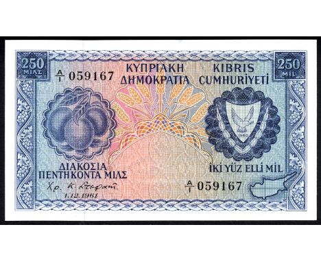
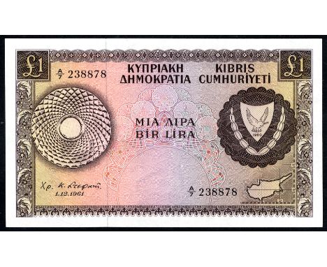
Cyprus P 39a Linzmayer B203a Republic of Cyprus 1 Pound 1 December 1961. Coat of arms of Cyprus at right map of Cyprus at lower right on front. Signature Stephani. Bekir Pasha aqueduct near Larnaca at left colonnades of the Polaestra of the Gymnasium Salamis at right on back. # A/7 238878. UNC
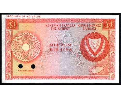
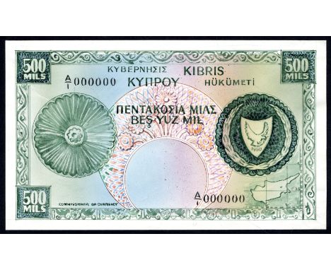
Lot 259
Cyprus P 39ct Linzmayer B203at Central Bank of Cyprus 1 Pound ND COLOR TRIAL. Orange. Coat of arms of Cypurs at right map of Cyprus at lower right on front. Bekir Pasha aqueduct near Larnaca at left colonnades of the Polaestra of the Gymnasium Salamis at right on back. Horizontal red overprint SPECIMEN OF NO VALUE in upper left margin on front and back. Black specimen number 55 in upper left margin on back. Punchec cancelled. Residue at right on back otherwise aUNC


Lot 296
East Caribbean States P 34g LinzmayerB218g Eastern Caribbean Central BankGrenada 50 Dollars (1994). Central Bank building at left center portrait of Queen Elizabeth II at right green-throated carib bird and flowers at upper right on front. Signature Venner. Brimstone Hill fortress in St. Kitts at left map of islands at center Les Pitons (volcanoes) in St. Lucia at right on back. # A 955769 G. UNC

Lot 297
East Caribbean States P 35m Linzmayer B219m Eastern Caribbean Central BankSt. Kitts 100 Dollars (1994). Central Bank building at left center portrait of Queen Elizabeth II at right green-throated carib bird and flowers at upper right on front. Signature Venner. Portrait of Sir William Arthur Lewis at left map of islands at center Central Bank headquarters building and fountain at right on back. # A 141866 M. UNC


Lot 430
Greenland P 21s1 Sieg 72A Credit Note 100 Kroner 16 January 1953 SPECIMEN. Portrait of Knud Rasmussen at left dog sled at Thule-rock at lower right on front. Signatures A.W. Nielsen - Børge Ibsen. Crown at upper center map of Greenland at right on back. Perforated SPECIMEN. # 0000000. PMG 64 EPQ Choice UNC

Lot 650
Madagascar P 41 Linzmayer B208f Leclerc/Kolsky 818b Banque de Madagascar1000 Francs28-Dec 1948. White woman representing France holding laurel branch and map of Madagascar at left Malagasy woman holding basket of fruit at right on front. Signatures Dejouany - Gonon. Seated woman with baskets at left huts and sea in background at center boy holding shovel at right on back. # Q.207 005165576 VF


-
109182 item(s)/page