We found 109182 price guide item(s) matching your search
There are 109182 lots that match your search criteria. Subscribe now to get instant access to the full price guide service.
Click here to subscribe- List
- Grid
-
109182 item(s)/page


![SANSON, Nicolas - Estats De L'Empire Du Grand Seigneur : [Middle East] hand coloured map, 545 x 405 mm, attractive frame, f &](https://cdn.globalauctionplatform.com/6c1c74da-ae62-4808-8609-a93601753ac3/b830266f-3e20-4ad7-c304-9e0d14a41680/468x382.jpg)


Lot 784
WILLIAM DARTON (1755-1819) BritishAn Accurate Map of Hindostan or India From the Best AuthoritiesEngraving on laid paper, published May 23rd 1785 by C Dilly & G Robinson, London, framed and glazed. 44 x 41 cm. CONDITION REPORTS: Generally good condition, expected wear, some slight staining/fading, some fold creased.


Lot 27
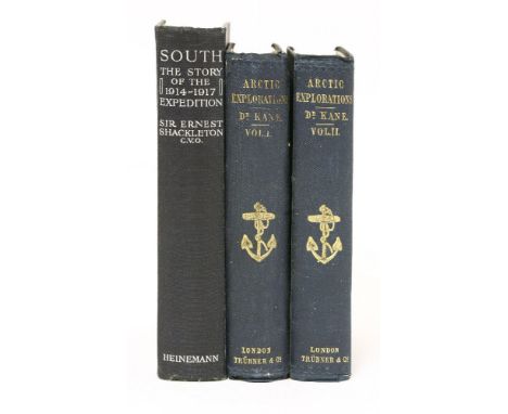
1- SHACKLETON (ERNEST HENRY): South, The Story of Shackleton's Last Expedition 1914-1917. London: William Heinemann, 1919. First edition, FIRST ISSUE, with Errata slip. Illustrated with a large folding map, Coloured frontispiece, 87 photographic plates (1 double-page), plus maps in the text. Bound in the publisher's original blue pictorial cloth gilt, upper cover lettered and stamped with image of 'Endurance' in silver gilt. Head & foot of spine and corners rubbed; edges of folding map little frayed; A near very good copy with the page edges browned, as usual with this book. This first impression was printed on poor quality paper and is prone to browning. 2- Kane, Elisha Kent: Arctic Explorations: The Second Grinnell Expedition in Search of Sir John Franklin in Two volumes. Philadelphia, Childs & Peterson, 1857. With a portrait and extra engraved title page (dated 1856) to both volumes, plus 18 plates and 3 charts (2 folding). Bound in the original publishers cloth; occasional foxing. (3)


Lot 51
British & Foreign Travel & Topography, including: White's Essex, 1863 (lacking the map; Howitt's Germany, 1842; Richardson’s Greenwich, 1834, with 3 plates); Goldsmith's Grammar of Geography, 2 copies: 1852 & nd (with maps & plates); Fraser’s Turkey ancient & Modern. 1854; 6 Baedeker guides; etc. (17)


Lot 151
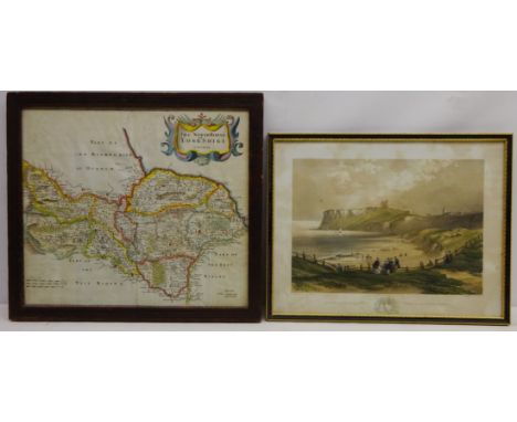
'The North Riding of Yorkshire', 17th century map by Robert Morden hand coloured 35cm x 40cm and 'Scarborough Castle, Looking over the North Sands', lithograph after H.B Carter pub. S. W Theakston Scarborough 31cm x 41cm (2) Condition Report Click here for further images, condition, auction times & delivery costs

Lot 152
Collection of watercolours and etchings including Lancaster, 17th century map by Richard Blome hand coloured, View of the Doge's Palace at Venice...', pub. Robert Sayer, etchings by Albany E. Howarth and R. H Smallridge, Perspective view of the city of Chichester ... Sussex, engraving c.1789 etc framed and unframed(qty) Condition Report Click here for further images, condition, auction times & delivery costs


Lot 456
Bancks & Co., plan of Manchester and Salford with their environsFrom an actual survey by Richard Thornton, commenced under the reign of his late Majesty and now dedicated by permission to his most gracious Majesty William IV, survey completed in the year 1831, showing all the streets and notable buildings of Manchester and Salford, 27x189cm fold out map contained in book form leather slip case.


Lot 509
Gregson (Matthew) "Portfolio Of Fragments Relative To The History And Antiquities Of The County Palatine And Duchy Of Lancaster"With numerous illustrations and foldout map of the Castle, printed for G F Harris's Widow & Brothers, 1817, bound in tan calf, further book by Gregson "Portfolio, Second Edition with Additions of Fragments Relative the History and Antiquities of the County Palatine and Duchy of Lancaster", printed by C A Worrall, Liverpool 1824, bound in tan calf. (2)


Lot 554
Jones (Enid Sophia) "Trevors Of Trevalyn And Their Descendants"Printed for private circulation 1955, Forrest (H E) "The Vertebrate Fauna Of North Wales", with twenty eight plates and a map, published by Wetherby & Co, London 1907, bound in green cloth, further books on Wales to include the history of ancient tenure of land in Wales and the Marches, history of the parish church of Wrexham etc. (11)

Lot 596
Milne (A.A.), "Winnie-the-Pooh"First Edition dated 1926, decorations by Ernest H. Shephard, published by Methuen & Co. Ltd, London, bound in green cloth with gilt decoration and lettering. CONDITION REPORT: lot 596Wear to spine top and bottom, scratch marks to back board, staining to front and back illustrations of "May", Word map written in ink, 3rd page name and address written in ink, mark to edge of pages. Images to follow.

Lot 625
"Athenian Letters Epistolary Correspondence of an Agent of the King of Persia"With a fold out map of Greece at the time of Peloponnesian War, printed for Codell, London 1810, bound in blue cloth, Winkles (H & B), "Cathedral Churches" in three volumes, published by Effingham, Wilson, London 1838. (5)


Lot 168
After James Pollard, The Grand Entrance to Hyde Park; After G.H. Andrews, Albert Memorial, Hyde Park; Windsor Castle; After T Bowles, Westminster Abbey; St Stephen Walbrook; St Pauls (mostly restrikes); After Clarkson Stanfield, The Opening of New London Bridge; The Royal Exchange; After Rowlandson & Pugin, View of the Tower; a map, a group of 11 engravings, mostly with hand colouring.(qty) G1


-
109182 item(s)/page