We found 109198 price guide item(s) matching your search
There are 109198 lots that match your search criteria. Subscribe now to get instant access to the full price guide service.
Click here to subscribe- List
- Grid
-
109198 item(s)/page


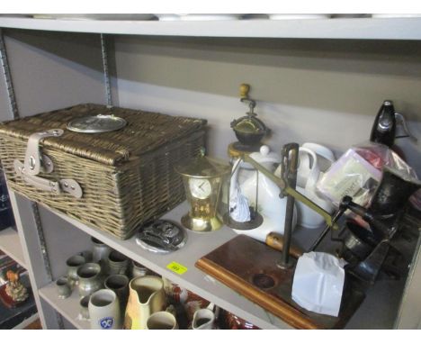
Lot 96
After Pieter Casteels, a pair of hand-coloured engravings depicting vases of flowers for April and July inscribed from 'The Collection of Rob. Furber, gardener at Kensington 1730, engraved by H. Fletcher', each 40.5 cm x 30 cm, together with a 17th Century Christopher Saxton map of Denbigh, hand coloured, a Blaeu map of Wales and three further maps, all depicting Welsh regions.Qty: 7


Lot 503
A collection of militaria to include Women's Transport Service F.A.N.Y (First Aid Nursing Yeomanry) badges and buttons, including five various red on khaki embroidered badges, thirteen small buttons, three larger buttons, cross cap badge and four other Victorian buttons, together with clear map satchel, various maps, Bartholemew's maps various, etc


Lot 167
A cased silver dishRoyal Irish Silver Limited, Dublin 1968 With sunray design, engraved on reverse 'one of four replicas originally by Joseph Walker, Dublin 1717' diameter 25.3cm, together with six other modern Irish silver, comprising: a dish, William Egan & Sons, Dublin 1973, fluted rectangular form, engraved with a map of Europe and 'Into Europe', length 20.5cm, a plate, Royal Irish, Dublin 1973, circular etched with a scene of 'St Patricks Cathedral Dublin', diameter 22.8cm, a 'Brandy' label modelled as the Gleninsheen collar, William Egan & Sons, Dublin 1973, a small tumbler cup, Royal Irish, Dublin 1970, a wine taster, Dublin 1988, and a money clip, Dublin 1999, weight 44.5oz. (7)Footnotes:ProvenanceThe first dish, The Kurt Ticher CollectionFor further information on this lot please visit Bonhams.com


Lot 182
A collection of more than 550 map postcards ' of which approximately 220 are standard-size and 320 modern-size; as well as some old postcard books and the last 17 ever issues of Picture Postcard Magazine, a monthly publication which ran for 40 years but ceased in May 2020 when it lost most of its advertising due to COVID-19. The postcards are mainly of parts of Britain, but there are a few foreign cards too. Most are from the 1970s and '80s, but one or two are older. Most cards are in very good condition. Some mileage in this lot for online sellers ' some of whom seek prices of £1 to £2 each for a standard-size card, although we would say those start prices are optimistic. The magazines are in near-mint condition (see photo of the feature the cover of just three of them). The books are second-hand and are 'Picture Postcards Of The Golden Age by Tonie and Valmai Holt (very good condition), 'Picture Postcards' by CW Hill (vgc), 'Picton's Priced Postcard Catalogue and handbook' 1982 (good), and 'Postcard Collecting ' A Beginner's Guide' (crease to cover otherwise good). They are also photographed.
Lot 274
Railwayana interest: Three LMS Dining Cars milk jugs, one by Royal Doulton, one by J&G Meakin and one by Grindley, all in Royal Scot Rose pattern, together with a set of six LMS Railway waistcoat buttons (1923-1947), three other transport buttons, luggage labels including Caledonian Railway Portsmouth from Perth and London & South Western Ry From Waterloo to Mill Hill via Portsmouth & Ryde, Pre 1923, 'The Great Isle of Wight Train Robbery' published by The Railway Invigoration Society and a hand coloured map of Hampshire and Isle of Wight, glazed and framed, 47 x 37cm

Lot 10
Railways. Pigot & Co.'s British Atlas, comprising the Counties of England (upon which are laid down all Railways Completed and in Progress), London: Pigot & Slater, Fleet-Street, and Fountain-Street, Manchester, c.1840. Folio (410 x 290 mm), title-page with engraved vignette, 'Address' leaf with list of contents at foot, 'Distance Table of 72 Principal Towns in England and Wales' (1 f.), 'Distance Table, in English Miles, of 73 Principal Towns in Ireland' (1 f.), 'Distance Table of the Principal Towns in Scotland' (1 f.), 'Distance Tables of the Principal Towns in the English Counties' (4 ff.), 41 hand-coloured steel-engraved maps (of 43: without 'Yorkshire' and 'Pigot's New Map of the Environs of London', but retaining the 3 large folding maps, 'England & Wales with Part of Scotland, including the New Lines of Canals, Rail Roads, etc.', 'New Map of Ireland embracing Every Recent Alteration', and 'New Map of Scotland with the Latest Improvements', each dated 1840), disbound, title-page soiled, folding maps with short splits to extremities of folds and neat linen-tape reinforcement to central intersection of folds verso, other maps with old tape-reinforcement along gutter (never affecting images), Buckinghamshire and Kent with juvenile pencil markings verso, closed marginal tear to Northumberland, a few marginal nicks to last few maps, Worcestershire extensively torn and crudely repaired (qty: 1) This edition apparently not in Chubb but cf. CCCCXXV-CCCCXXVIII. Sold as a collection of maps.
Lot 101
Bible (English; Authorised). The Holy Bible. Containing the Bookes of the Old and New Testament, Cambridge: John Field, [1660]. 2 volumes, large folio (457 x 290 mm), contemporary red goatskin gilt by Samuel Mearne, spines richly gilt in compartments incorporating the royal cipher of Charles II, each cover gilt with 24 impressions of the royal cipher in two different sizes between concentric floral and fillet rolls, comb-marbled endpapers, all edges and turn-ins gilt, pp. [16] 680; [2] 681-1103 [1] 1-258 [2], [2] 1-338, signatures [par.]-2[par.]4 A-3K6 3L4; pi1 3M-4Y6 4Z8 a-x6 y4 (y4=blank), A-2D6 2E8, ruled in red throughout, engraved general title-page to volume 1 by Lombart after Diepenbeeck depicting Solomon enthroned (undated; counted in pagination by ESTC), volume 2 with letterpress general title-page ('The Second Part of the Holy Bible', dated 1660) and letterpress New Testament title-page (dated 1659), engraved arms of Charles II by Hollar to each volume, 118 engraved plates mainly by Visscher or Le Blond after Heemskerck, de Bruyn, de Vos, Coninxloo, Potter and others (mainly double-page, and including a folding panorama of Jerusalem on two sheets), engraved double-page map by Hollar (facing volume 1 p. 298). Bindings variably scuffed and rubbed, superficial score-marks, ties possibly renewed, occasional light browning to contents, volume 1 with closed tear in C2, plate at p. 12 with closed tear in gutter and fraying along top edge, plate at p. 468 with split to foot of central fold, volume 2 with short closed tears in a1, D4 and N6, closed transerve tear through P2 to no loss of text, marginal nicks or tears to a few plates (facing pp. 872, 1008 and 138), and a longer closed tear and marginal fraying to panorama of Jerusalem (qty: 2) Darlow & Moule (1903 edition) 525; ESTC R17044. A splendid copy of the illustrated reissue by John Ogilby of John Field's two-volume folio Bible of 1659, in contemporary red goatskin by Samuel Mearne (1624-1683), royal binder to the restored Charles II. According to Darlow and Moule the reissue had a new general title-page dated 1660 and reading 'illustrated with Chorographical Sculps by J. Ogilby'. Our copy appears to retain the original general title-page, as it is undated and does not contain the reference to Ogilby. The number of plates is known to vary; ESTC calls for a total of 102 only. Provenance: Sir Richard Fanshawe, 1st Baronet (1608-1666), diplomat, poet, translator and prominent royalist; given by him to Sir Edmund Turnor (1619-1707) of Stoke Rochford, Lincolshire, with Turnor's engraved bookplate (dated 1702) and 18th-century ink inscription 'A present to Sir Edm. Turnor from the Rt Hon. Sir Richd Fanshawe' to the initial blank of each volume (volume two with additional 20th-century annotation 'his brother-in-law, Ambassador at the Court of Spain').Without the dedication leaf to Charles II found in some other copies (see note). Volume 2 additionally with short closed tear to foot of first title-page (pi1) and spill-burn in 3X5 affecting one letter verso.

Lot 104
Bible (English; Geneva Version). The New Testament of our Lord Jesus Christ, translated out of Greeke by Theod. Beza: with briefe Summaries and Expositions upon the hard places by the said Authour, Joac[him] Camer[arius] and P. Loseler Villerius. Englished by L. Tomson. Together with the Annotations of Fr. Junius upon the Revelation of S. John, London [i.e. Amsterdam]: imprinted by the Deputies of Christopher Barker, printer to the Queenes most Excellent Majestie [i.e. Jan Fredericksz Stam], 1599 [i.e. 1640 or later?]. 4to (215 x 170 mm), contemporary reversed calf decoratively panelled in blind, New Testament and Table only, signatures 3A-3P8 3R4, ff. 121 [11], title within woodcut border, woodcut map of the Holy Land on 3A2 verso, woodcut initials throughout, pencilled ownership inscription 'T Robinson Jun., Bury, 1766' to front pastedown, old staining, old paper reinforcement to fore margins of signatures 3N-3O, small hole in 3R3-4 affecting a few letters (qty: 1)
![Saxton (Christopher). Eboracensis comitatus, [London], 1577 [i.e. 1579]. Engraved map of Yorkshire by Augustine Ryther after](https://cdn.globalauctionplatform.com/64361b91-8ff9-4015-9611-ad160112fc1d/996dd9a8-be99-45b4-b147-ad5701091d7b/468x382.jpg)
Lot 11
Saxton (Christopher). Eboracensis comitatus, [London], 1577 [i.e. 1579]. Engraved map of Yorkshire by Augustine Ryther after Christopher Saxton, contemporary hand-colouring with later enhancement, laid down, trimmed to neatline, substantial loss along central fold, lesser disruption along other folds, small area of loss upper left (costing a few letters in 'Westmorelandia'), a little dust-soiling, small circular stain lower right, mounted, framed and glazed, 528 x 700 mm, not examined out of frame (qty: 1) Cf. Chubb I. The first printed county map of Yorkshire.
Lot 113
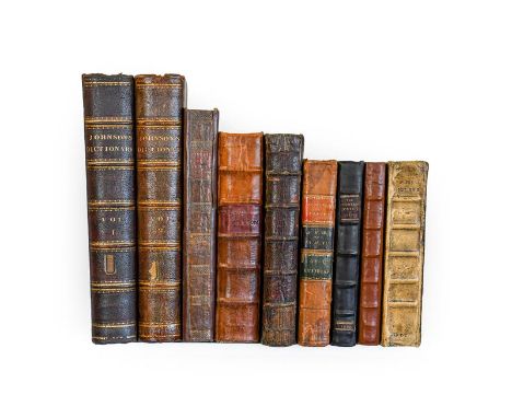
Dalton (Michael). The Countrey Justice; containing the Practice of the Justices of the Peace as well in as out of their Sessions ... Now again enlarged with many Precedents and Resolutions of the Quaeres contained in the former Impressions: and the Statues of King Charles I and His Majesty King Charles II added under their several Titles, London: John Streater [and others], 1666. Folio (282 x 180 mm), contemporary blind-ruled sheep, rebacked retaining original label, bound without preliminary and possibly final blank, spill-burn in 2N6 - Johnson (Samuel). A Dictionary of the English Language ... The Fourth Edition, revised by the author, London: printed by W. Strahan, for W. Strahan [and others], 1773. 2 volumes, folio (410 x 235 mm), 19th-century maroon half morocco, gilt morocco labels '15th Regt' to front boards, manuscript presentation leaf inset into initial blank ('Doctor Badenach requests the officers of the 15th Regiment to accept for their library Johnson's Dictionary & a map of England, as a small mark of that regard which he will ever entertain for them, 20 Upper Baker St. London, Febry 22nd 1826'), imperfect, volume 1 title-page with marginal loss and extensive closed tears, laid down, substantial loss to volume 2 title-page and subsequent leaves - Nalson (John). An Impartial Collection of the Great Affairs of State, from the Beginning of the Scotch Rebellion in the Year MDCXXXIX to the Murther of King Charles I, London: for S. Mearne, [and others; volume 2: for A. Mearne ... ], 1682-3. 2 volumes, folio (326 x 195 mm), contemporary non-uniform calf, refurbished, volume 2 rebacked, each volume with engraved frontispiece and 'The Mind of the Frontispiece' leaf, volume 2 with engraved portrait, incomplete, lacking at least volume 1 leaves A2-4 - Southwell (Henry). The New Book of Martyrs, London: for J. Cooke, No. 17, in Pater-Noster Row, c.1785. Folio (365 x 230 mm), 20th-century boards, partly preserving original spine, incomplete (40 plates of 42 or 43?: lacking plates 19 and 23a; and lacking at least quires 3I-3L), front inner hinge cracked - Fuller (Thomas). The Historie of the Holy Warre, 4th edition, Cambridge: Thomas Buck, 1651. Folio (286 x 180 mm), contemporary sheep, rebacked, engraved frontispiece (preceded by 'A declaration of the Frontispiece' leaf), engraved folding map (staining and repaired loss along folds), incomplete (lacking at least text-leaves C2-3) - and 2 others including another copy of Fuller, Holy Warre, 3rd edition, 1647, bound with The Holy State, 3rd edition, 1652, Holy Warre lacking at least the frontispiece and folding map, Holy State incomplete at end but with numerous engraved portraits in the text (qty: 9) ESTC R29291 (Dalton), T117232 (Johnson), R6970 & R229450 (Nalson), T105997 (Southwell), R12547 (Fuller).
Lot 118
Johnson (Samuel). A Journey to the Western Islands of Scotland, 1st edition, 1st issue, London: W. Strahan; and T. Cadell, 1775. 8vo (206 x 122 mm), contemporary marbled calf, rebacked, pp. [2] 384 [2], errata leaf (12 lines), title-page spotted, soiled and with wax-seal residue and related tears, a little spotting and a few pencil-marks elsewhere - Erasmus (Desiderius). Twenty Two Select Colloquies ... [Edited by] Sir Roger L'Estrange, London: for Daniel Brown [and others], 1725. 8vo (197 x 115 mm), contemporary panelled calf, engraved portrait frontispiece, a little loss to head of spine - Nicolson (Joseph, & Richard Burn). The History and Antiquities of the Counties of Westmorland and Cumberland, 1st edition, London: W. Strahan; and T. Cadell, 1777. 2 volumes, 4to (270 x 217 mm), contemporary marbled calf, rebacked and relined with original spines laid down, 2 engraved folding maps by Thomas Kitchin, engraved bookplates of Thomas Dawson, 1st Viscount Cremorne (1726-1813), bindings scuffed, wear to corners, map of Westmorland with linen tape repair verso - Dickens (Charles). The Life and Adventures of Martin Chuzzlewit, 1st edition, London: Chapman and Hall, 1844. 8vo (216 x 130 mm), contemporary green half calf gilt, etched frontispiece, additional vignette title-page (with '£100') and 38 plates, all by Phiz, errata leaf (14 lines), Courtauld family ownership inscription to initial blank, half-title discarded, plates browned, plate facing p. 160 with one corner reattached - and 10 others, 19th-century literature, leather bindings, including a set of the Fireside Dickens (qty: 36) ESTC T84319 (Johnson), T138079 (Erasmus), T56128 (Nicolson).

Lot 12
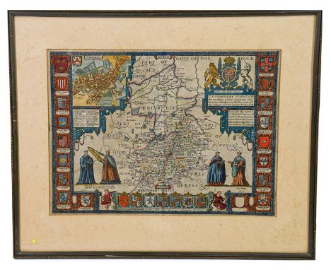
Speed (John). Breknoke, both Shyre and Towne described, London: to be solde ... J. Sudbury and George Humbell, [1611 or later], engraved map with inset plan of Brecon, browned, loss to lower margin, framed and glazed, 410 x 520 mm - Morden (Robert). The County Palatine of Chester, London: Abel Swale, Awnsham and John Churchill, [1695 or later], engraved map with contemporary outline colour, mounted and framed, mount aperture 355 x 425 mm - Blome (Richard). A Mapp of ye County of Essex: with its Hundreds, [London: printed by Thomas Roycroft, c.1673], engraved map with title within decorative cartouche, arms of Thomas Barrington, damp-staining upper right, framed and glazed, 265 x 360 mm - and 11 others, all framed and glazed, including Kitchin, A New Map of Cheshire, c.1786 (2 copies), Herman Moll, Spain and Portugal according to the Newest Observations, c.1720, Herman Moll, The County Palatine of Chester, c.1720, John Cowley, An Improved Map of Lancashire, c.1744, and more (qty: 14) Cf. Chubb XXII (Speed), CXIII (Morden), XCIX (Blome).
Lot 13
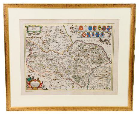
Speed (John). Cambridgshire described with the devision of the hundreds, the Townes situation, with the Armes of the Colleges of that famous Universiti, [London]: Performed by John Speede, and are to be solde in Popes Head Alley, by John Sudbury and G. Humbell, [1611 or later], hand-coloured engraved map, with inset map of Cambridge, strapwork cartouche incorporating the royal arms, arms of the colleges along edges, toned, a few shallow chips along top edge, 25 mm closed tear extending into title of inset plan, small spill-burn between the two figures lower right, mounted, framed and glazed (not examined out of frame), mount aperture 410 x 535 mm (qty: 1) Cf. Chubb XII or XV; Humble's imprint appears in the maps of the first edition of 1611, the re-issue of 1627, and another issue published by John Dawson in 1646 (not in Chubb).

Lot 14
Speed (John). Cumberland and the Ancient Citie Carlile described with many Memorable Antiquities therein found observed, London: to be sould in Popes head Alley ... by J. Sudbury and Georg. Humble, 1610 [i.e. 1616]. Hand-coloured engraved map with inset plan of Carlisle, Latin text verso, mounted, glazed both sides and framed, mount aperture 396 x 520 mm, together with: ibid. The Countie Westmorland and Kendale the Cheif Towne described. Wth the Armes of such Nobles as have bene Earles of either of them, London: to be sold by George Humble in Popes head alley, [1616]. Hand-coloured engraved map with inset plan of Kendal, Latin text verso, mounted, framed and glazed, 396 x 520 mm (qty: 2) Chubb XXIVa. Both maps are from the Latin edition of Speed's Theatre of the Empire of Great Britaine, which Chubb describes as 'extremely rare'.
![Speed (John). The Countie Pallatine of Lancaster described and divided into Hundreds, [London]: Performed by John Speed. And](https://cdn.globalauctionplatform.com/64361b91-8ff9-4015-9611-ad160112fc1d/2906fe57-e8d9-46f4-ac56-ad57010920cc/468x382.jpg)
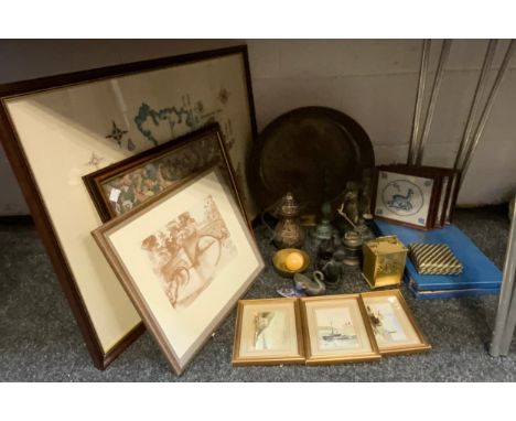
Lot 16
Speed (John). The Countie Pallatine of Lancaster described and divided into Hundreds, [London]: Performed by John Speed. And are to be solde in Popes head alley by G. Humbell, [1611 or later], hand-coloured engraved map (390 x 504 mm), with inset plan of Lancaster and 8 roundel portraits of English monarchs, English text verso, trimmed to neatline along left and right edges (margins consequently extended), a couple of very small chips to top edge not affecting image, central fold with repaired closed tear to foot, glazed both sides and framed (glass cracked on verso), together with: Ogilby (John). The Road from York to West-Chester ... from York to Tadcaster ...Thorner ... Leeds ... Burstall ... Ealand ... Rochdale ... Manchester ... Eccles ... Warrington ... with a Branch from Mancester to Derby, [London, 1675 or 1698], hand-coloured engraved strip road map (372 x 462 mm), framed and glazed, and another map of Lancashire (19th century, framed and glazed) (qty: 3) Cf. Chubb XII or XV for Speed; Humble's imprint appears in the maps of the first edition of 1611, the re-issue of 1627, and another issue published by John Dawson in 1646 (not in Chubb).
![Speed (John). The North and East Ridins of Yorkshire, [London]: Performed by John Speede, and are to be sold in Popes heade A](https://cdn.globalauctionplatform.com/64361b91-8ff9-4015-9611-ad160112fc1d/c6ee0d46-5759-4899-bc62-ad570109212d/468x382.jpg)
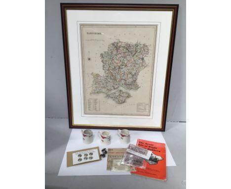
Lot 17
Speed (John). The North and East Ridins of Yorkshire, [London]: Performed by John Speede, and are to be sold in Popes heade Alley ... by John Sudbury and George Humbell, 1610 [i.e. 1611 or later], hand-coloured engraved map, inset plans of Richmond and Hull, English text verso, evidence of wear to plate towards foot including to plan of Hull, mileage cartouche and decorative border, mounted, glazed both sides and framed (affixed to mount with clear-tape tabs verso), mount aperture 387 x 506 mm, together with - ibid. York Shire, [London]: Performed by John Speed and are to be solde in Popes head alley, against the Exchange by John Sudbury and G. Humble, 1610 [i.e. 1616], hand-coloured engraved map, Latin text verso, 80 mm closed tear extending into image from top margin, mounted, glazed both sides and framed (affixed to mount with clear-tape tabs verso, mount aperture 394 x 520 mm, not examined out of frames (qty: 2) Cf. Chubb XXII or XXV for The North and East Riding and XXIVa for York Shire. The second map, 'York Shire', is from the 1616 Latin edition of Speed's Theatre of the Empire of Great Britaine, which Chubb describes as 'extremely rare'. Concerning the first map ('The North and East Ridins'), Humble's imprint appears in the maps of the first edition of 1611, the re-issue of 1627, and another issue published by John Dawson in 1646 (which is not in Chubb).
![Speed (John). York Shire, [London:] to be solde in Popes head alley, against the Exchange by John Sudbury and G. Humble, 1610](https://cdn.globalauctionplatform.com/64361b91-8ff9-4015-9611-ad160112fc1d/7bfe3d92-0fa2-4e6c-b817-ad57010921ad/468x382.jpg)
Lot 18
Speed (John). York Shire, [London:] to be solde in Popes head alley, against the Exchange by John Sudbury and G. Humble, 1610 [i.e. 1611 or later], hand-coloured engraved map, mounted, framed and glazed, mount aperture 400 x 525 mm, evidence of repair to head of central fold, not examined out of frame (qty: 1) Cf. Chubb XXII or XXV. Humble's imprint appears in the maps of the first edition of 1611, the re-issue of 1627, and another issue published by John Dawson in 1646 (which is not in Chubb).
Lot 19
Yorkshire. A group of 4 maps, 17th century, comprising: 1) Ogilby (John). The Road from Whitby in Com. Ebor. to Durham [and:] The Road from Ferrybridge to Boroughbridge, continued to Barnard Castle in Com. Ebor. [London, 1675 or 1698], 2 hand-coloured engraved strip road maps, separately mounted, gilt-framed and glazed, mount apertures 364 x 475 mm; 2) [Jansson, Jan]. Ducatus Eboracensis pars borealis. The North Ridinge of Yorkeshire, [Amsterdam, 1646 or later], hand-coloured engraved map with strapwork mileage cartouche and allegorical title cartouche, coats of arms top right, Latin text verso, central fold split at head (tape-repaired verso), mounted, glazed both sides and gilt-framed, mount aperture 430 x 547 mm; 3) [Drayton, Michael]. [Allegorical map of Yorkshire from Poly Olbion, 1622], hand-coloured engraved map, mounted, framed and glazed, mount aperture 263 x 325 mm, all items with labels of the Country Gallery, Great Ayton, not examined out of frames (qty: 4) The two Ogilby maps are numbers 99 and 95 from his work Britannia, first published in 1675; these examples are from either one of the other editions published in 1675 or the 1698 reprint, as the numbers do not correspond to those provided by Chubb for the maps in the first edition.

Lot 194
Haggard (H. Rider). A collection of his novels, early editions, all 8vo, original cloth unless otherwise stated, including: 1) Dawn. New Edition, London: Longmans [et al.], 1896, 16 plates by D. Murray Smith, 2) The Witch's Head. Twenty-sixth thousand, London: Spencer Blackett, c.1893, 16 plates by Charles Kerr, 3) King Solomon's Mines. Revised edition, London: Cassell and Company, Ltd., 1912, contemporary red morocco gilt, folding colour map, 32 plates by Russell Flint, 4) Jess. New Edition, London: Smith, Elder, & Co., 1900, 12 plates, 5) Allan Quatermain. New Edition, London: Longmans, Green, and Co., 1888, 20 plates by C. H. M. Kerr, 16 pp. advertisements, 6) Colonel Quaritch V.C., 1st one-volume edition, London: Longmans, Green and Co., 1889, recased and relined, 7) Heu-Heu or the Monster, New York: Grosset & Dunlap, c.1924, dust jacket, and 38 others similar, including early editions of The World's Desire, The Wizard, Pearl Maiden, Benita, etc. (qty: 45) Whatmore F1 6d (Dawn), F2 6c (The Witch's Head), F6 6c (Allan Quatermain), F9 6a (Colonel Quaritch V.C.). Provenance: The H. Rider Haggard Collection of Geoffrey Bullock, Provenance: The H. Rider Haggard collection of Geoffrey Bullock, president of The Rider Haggard Society
![Yorkshire. Four maps of Yorkshire, 17th-19th century, comprising: 1) Tuke (John). Map of the County of York, [London?]: repub](https://cdn.globalauctionplatform.com/64361b91-8ff9-4015-9611-ad160112fc1d/d1eed494-986e-4c4a-9e58-ad57010922cf/468x382.jpg)
Lot 20
Yorkshire. Four maps of Yorkshire, 17th-19th century, comprising: 1) Tuke (John). Map of the County of York, [London?]: republished 1816, large hand-coloured engraved map, divided into 2 sheets (east and west) each of 8 sections and mounted either side of a sheet of card backing, glazed both sides and framed, some old staining and adhesive staining along section edges, west sheet with small area of loss to central fold, a few other marks, approximate dimensions 1180 x 720 mm; 2) [Blaeu, Joan]. Ducatus Eboracensis pars borealis. The North Riding of York Shire, c.1648, hand-coloured engraved map, decorative cartouche of fishermen, French text verso, mounted, glazed both sides and framed, 395 x 510 mm; 3) Bowen (Emanuel, & Thomas Kitchin). An Accurate Map of the North Riding of York Shire, London: John Bowles, Carington Bowles, and Rob[er]t Sayer, [1785 or later], hand-coloured engraved map, inset view of York, decorative cartouches, browning, damp-stain to lower margin, framed and glazed, 585 x 750 mm, 4) Bowen (Emanuel, & Thomas Kitchin). An Accurate Map of the County of York, London: Rob[er]t Wilkinson, Carington Bowles, Rob[er]t Sayer, [1785 or later], hand-coloured engraved map, decorative cartouches, browning, 585 x 750 mm, together with 1 other map (Pierre Mortier, Carte particuliere des costes de Flandres, de Picardie et de Normandie, c.1700) (qty: 5) Cf. Chubb CXCIX or CC for the two Bowen maps.One document is noticeably damp-stained; otherwise overall condition very good. Many documents relate to transactions made by Richard Heeles [Heelis] the elder and younger of Draughton during the late 17th century with various parties from Draughton and other settlements in Yorkshire (e.g. Easby). The Kildwick Grange documents include a form of quitclaim signed by John Coates of Kildwick Grange in 1691. Apparently it was his forebear, also John Coates, for whom the house was built in the 1620s.
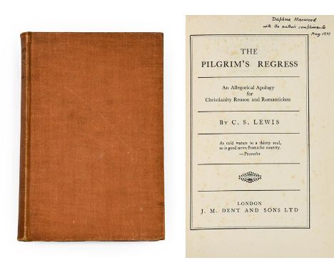
Lot 202
Lewis (C. S., 1898-1963). The Pilgrim's Regress. An Allegorical Apology for Christianity, Reason and Romanticism, London: J. M. Dent and Sons Ltd, 1933. 8vo, original orange cloth (slightly rubbed and dust-soiled), map endpapers, spotting to half-title, title-page and final text-leaf (qty: 1) First edition, presentation copy, inscribed by Lewis to 'Daphne Harwood, with the author's compliments, May 1933' on the title-page. Daphne Harwood (née Olivier, 1889-1950) was the wife of Lewis's Oxford friend (Albert) Cecil Harwood (1898-1975), and a friend of Lewis's in her own right. While Cecil is not typically reckoned among the usual roll-call of Inklings members, he remained very much part of Lewis's circle, and is perhaps best remembered as a leading advocate of anthroposophy and the Steiner-Waldorf teaching method, to which he was introduced by Daphne. Provenance: Laurence Harwood OBE (1933-2020), regional director, National Trust, son of Cecil and Daphne Harwood, and godson of C. S. Lewis, noted as 'one of the few remaining people who really knew C. S. Lewis' (Deborah Higgens, 'A Personal Tribute to Laurence Harwood, OBE', C. S. Lewis Foundation official blog, 14 December 2020, accessed 24 May 2021). Further reading: Laurence Harwood, C. S. Lewis, My Godfather: Letters, Photos, and Recollections (Downers Grove, IL: IVP Books, 2007).

Lot 208
Stephanides (Theodore). The Golden Face, 1st edition, London: The Fortune Press, 1965. 8vo, original cloth, dust jacket, inscribed by the author 'To Dr. T. M. Robb, in memory of old days at Lambeth Hospital, London, 21-7-1966, Th. Stephanides' on the front free endpaper - ibid. Climax in Crete, 1st edition, London: Faber and Faber Limited, 1946. 8vo, original cloth, dust jacket (chipped), map frontispiece, ownership inscription to title-page - Palamas (Kostes). The Twelve Words of the Gipsy. Translated by Theodore Ph. Stephanides and George C. Katsimbalis, 1st edition thus, Athens: F. Constantinidis & C. Michalas [imprint in colophon], 1974. 4to, original printed wrappers (nicked, spine toned), edges untrimmed, inscribed by the translator 'To John and Camilla Pisani with best wishes, Theodore Stephanides, London, January 1975' on the front free endpaper - ibid. A Hundred Voices. Translated by Theodore Ph. Stephanides and George C. Katsimbalis, 1st edition thus, London [probably Athens: F. Constantinidis & C. Michalas, 1976]. 4to, original printed wrappers, inscribed by the translator ''For John and Camilla, with best compliments, Theodore Stephanides, London, December 1976' on the front free endpaper - [Lowenfels, Walter]. USA with Music. An Operatic Tragedy, 1st edition, number 342 of 400 copies only, Paris: Carrefour Editions, 1930. 8vo, original printed wrappers, later slipcase - and 2 others (qty: 7)

Lot 21
Blane (William Newnham). An Excursion through the United States and Canada during th Years 1822-23. By an English Gentleman, 1st edition, London: Baldwin, Cradock, and Joy, 1824. 8vo (202 x 122 mm), contemporary mottled red sheep, folding letterpress table (with splits to folds), engraved folding map ('The Straits of Niagara, from a Map by Mr. Darby', with extensive closed tear), lacking one other map (qty: 1) Uncommon. Contains chapters dedicated to slavery and to the Native American populations of the areas visited.

Lot 22
Carr (Sir John). The Stranger in France; or, a Tour from Devonshire to Paris, 2nd edition, London: J. Johnson, 1807. 8vo (203 x 125 mm), contemporary half calf (front joint cracked), [4] 373 [1] pp., 12 aquatint plates, contemporary ownership inscriptions to endpapers including 'S. Levy', some spotting and soiling - [Nougaret, Pierre Jean-Baptiste]. Beautés de l'histoire de l'Angleterre, 3rd edition, Paris; Le Prieur, 1819. 8vo (159 x 94 mm), contemporary French half calf (some wear, spine pulled at foot), 408 pp., half-title, 16 engraved costume plates (occasional damp-staining) - and 12 others (not collated), travel and similar, all leather-bound, and including Hugh Gray, Letters from Canada, 1st edition, 1809 (front board detached, lacking map), Falconer, The Shipwreck, New Edition, 1802 (contemporary tree calf, good condition), Prescott, History of the Conquest of Peru, 7th edition, 1853 (contemporary calf gilt), Motley, The Rise of the Dutch Republic, New Edition, 1901 (contemporary half calf), Steevens, With Kitchener to Khartoum, 8th edition, 1898 (contemporary half calf), and others (qty: 16)
Lot 28
Matthews (John). A Voyage to the River Sierra-Leone, on the Coast of Africa ... With an Additional Letter on the Subject of the African Slave Trade, 1st edition, London: for B. White and Son, 1788, bound after: Bowdler (Thomas). Letters written in Holland in the Months of September and October, 1787, 1st edition, London: printed for the benefit of a charitable institution at Bath, 1788. 2 works in 1 volume, 8vo (212 x 125 mm), 19th-century red half calf (spine somewhat faded and rubbed), edges dyed yellow, Matthews with engraved folding frontispiece ('A View of the Island of Bananas'), engraved folding map, frontispiece spotted and offset, map offset and with short closed tear to inner fold affecting frame only (old repair verso), a few pages with manuscript braces added to margins in black ink, spotting to last few pages, Bowdler with 2 engraved folding maps (one as frontispiece) of which both slightly browned and causing spotting to adjacent leaves including title-page, title-page and subsequent few leaves also with damp-stain to lower outer corner (qty: 1) ESTC T6213 (Matthews), T63080 (Bowdler); Sabin 46888 (Matthews). Provenance: George Wilbraham (1779-1852), Whig politician, of Delamere House, Northwich, Cheshire (bookplate).
![Crete. Insula Candia olim Creta. N Visscher exc[udebat], Amsterdam, c.1680, engraving with apparently contemporary hand-colou](https://cdn.globalauctionplatform.com/64361b91-8ff9-4015-9611-ad160112fc1d/f7eca30f-d0a9-4cfe-a878-ad570109124f/468x382.jpg)
Lot 3
Crete. Insula Candia olim Creta. N Visscher exc[udebat], Amsterdam, c.1680, engraving with apparently contemporary hand-colouring, in two sections, with panorama of the Turkish siege of Crete at head and map of Crete at foot, some loss to head of central fold, contemporary manuscript numbering to margin, framed and glazed, plate size 410 x 510 mm, visible sheet size 525 x 620 mm (qty: 1)
Lot 30
Querbeuf (Yves Mathurin Marie Tréaudet, & others, editors). Lettres édifiantes et curieuses, écrites des missions étrangères. Nouvelle édition. Mémoires du Levant [... Amérique ... Indes ... Chine], Toulouse: Noel-Etienne Sens, Auguste Gaude, 1810-11. 26 volumes, 12mo (164 x 92 mm), contemporary mottled sheep, rebacked and relined at an early date, spines richly gilt in compartments with twin morocco labels, half-title to each volume, 54 engraved maps and plates (nearly all folding), variable light browning, folding map facing volume 16 p. 310 with old linen-tape repair verso (qty: 26) Sold as a collection of maps and plates; a full collation has not been established. The maps include Kino's Passage par terre à la Californie, Fritz's Cours du fleuve Maragnon autrement dit des Amazones, and similar; the plates include views, portraits of indigenous peoples including an Iroquois woman, a depiction of Chinese characters, and two folding tables relating to Chinese astronomy. Provenance: George Wilbraham (1779-1852), Whig politician, of Delamere House, Northwich, Cheshire (bookplates).

Lot 32
Sandys (George). Travells, containing an History of the Original and Present State of the Turkish Empire ... The Mahometan Religion and Ceremies. A Description of Constantinople ... Also, of Greece ... Egypt, Armenia, Grand Cairo, Rhodes, the Pyramides, Colossus ... Alexandria ... the Holy Land ... the Jews ... Italy ... Cyprus Crete, Malta ... and other places, 6th edition, London: for Rob. Clavell [and others], 1670. Folio (300 x 188 mm), contemporary panelled calf (worn, spine-label renewed in the 19th century, front board and free endpaper detached), pp. [6] 240, engraved additional title-page, folding map, folding panorama of Constantinople, engravings throughout the letterpress (mainly plans, views and antiquities), engraved title with partial hand-colouring, map slightly browned and with 55 mm split to foot of one fold, marginal burn-hole to Q5, a few other marks (qty: 1) Blackmer 1484; ESTC R15984. Provenance: Roger Lee (19th-century armorial bookplate).
Lot 39
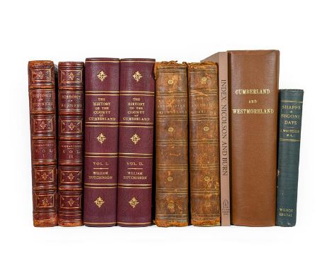
Richardson (Joseph). Furness Past and Present: its History and Antiquities, 1st edition, Barrow-in-Furness: J. Richardson, 1880. 2 volumes, 4to (267 x 207 mm), contemporary red morocco gilt over bevelled boards, gilt edges, [4] xxii 261 [4], [4] 316 pp., volume 1 with photogravure portrait frontispiece, chromolithographic additional title-page, chromolithographic dedication-page, 2 maps (one map, 'Morecambe Bay', described as a 'two-page illustration', the reason unclear), 5 plates of arms heightened in gold and silver, 28 further plates (mainly tinted lithographs; the two plates listed as facing p. 189 are in fact on a single sheet), volume 2 with photogravure portrait frontispiece, chromolithographic dedication leaf (without the additional title-page), 32 plates (apparently of 34: without plates 'Western Window, Furness Abbey' and 'Barrow in 1844 and 1863' facing pp. 139 and 197; the two plates listed as facing p. 141 in fact on a single sheet), volume 1 rebacked with original spine laid down and inner hinges strengthened, final leaf laid onto rear pastedown with consequent paper-disruption along gutter, together with - Hutchinson (William). The History of the County of Cumberland, and Places Adjacent, 1st edition, Carlisle: printed by F. Jollie, 1794. 2 volumes, 4to (276 x 210 mm), recent maroon quarter morocco, 2 engraved additional title-pages, 54 engraved plates and maps (of 57), several folding, spotting, folding maps with splits, tears and repairs, folding map facing volume 1 p. 42 silked, text not collated - Nicolson (Joseph, & Richard Burn). The History and Antiquities of Westmorland and Cumberland, 1st edition, London: W. Strahan; and T. Cadell, 1777. 2 volumes, 4to (270 x 210 mm), contemporary diced half russia, 2 engraved folding maps, bindings worn, marbled paper covering entirely perished from volume 1 front board, text not collated - and 3 others (not collated: Whellan, The History and Topography of Cumberland and Westmoreland, 1st edition, Pontefract, 1860, modern cloth; Whiteside, Shappe in Bygone Days, 1st edition, Kendal, 1904, original cloth; Index to Nicolson and Burn, reprint, 2011, original wrappers) (qty: 9) ESTC T139564 (Hutchinson), T56128 (Nicolson). Most of the plates in Richardson's work are dual-tint lithographic views of country seats. Despite the absence of two listed plates from our copy, it contains in total 69 plates (including the frontispieces and maps), whereas Library Hub calls for 62 only.

Lot 41
Whitaker (Thomas Dunham). The History and Antiquities of the Deanery of Craven, in the County of York. The Second Edition, with many Additions, Corrections, Map, and View of Gentlemen's Seats, Antiquities, etc., London: J. Nichols and Son, 1812. Folio (385 x 265 mm), contemporary calf, gilt palmette roll to covers, all edges gilt, vii 530 pp., engraved folding map, 18 letterpress pedigrees (a few also folding), 72 engraved or aquatint plates in total, many hand-coloured, and including 2 unlisted plates (facing pp. 32 and 415), 17 hand-coloured duplicates of uncoloured plates (mainly of country seats), and one plate (Eshton Hall) in two states (aquatint and engraved; both uncoloured), the duplicates all unlisted, front cover detached, offsetting, a few repairs to folding pedigrees (qty: 1) Deluxe large-paper copy; the coloured duplicate plates are not present in other copies we have traced, and many of the remaining plates which are coloured in our copy are uncoloured in others.

Lot 42
Armour (G. Denholm). Mr. Jorrock's Lectors. From Handley Cross by R. S. Surtees, London: Hodder and Stoughton, 1910. 4to (242 x 180 mm), contemporary red crushed half morocco, pictorial vignette made up of morocco onlays to spine, top edge gilt, 25 tipped-in colour plates - Blew (William C. A.). The Quorn Hunt and its Masters, London: John C. Nimmo, 1899. Large 8vo (258 x 168 mm), near-contemporary red crushed half morocco, spine gilt with hunting motifs, top edge gilt, 12 colour plates after Henry Alken (2 double-page), folding map, uneven fading to cloth sides - De Trafford (Sir Humphrey). The Foxhounds of Great Britain and Ireland. Their Masters and Huntsmen, 1st edition, London: Walter Southwood & Company, 1906. Folio, original half morocco gilt, photogravure plates, spine slightly sunned, joints rubbed, a little sunning to covers - Maxwell-Lyte (H. C.). A History of Eton College, 1st edition, London: Macmillan and Co., 1877. 8vo (214 x 142 mm), original presentation binding of full vellum gilt over bevelled boards, Eton leaving inscription dated 1888 to initial blank, binding slightly dust-soiled, spotting to endpapers - Hussey (Christopher). Eton College, 2nd edition, London: Country Life, 1926. 4to (305 x 240 mm), contemporary blue quarter morocco, slightly marked - together with 13 others comprising 12 copies of the Jorrocks novels (either in red half morocco or red half calf, rubbed), and Berkeley, Reminiscences of a Huntsman, 1854 (with 3 plates of 4) (qty: 18)

Lot 45
Bindings. 1) The Salmon Rivers and Lochs of Scotland. By W. L. Calderwood, 1st edition, London: Edward Arnold, 1909. 8vo (230 x 155 mm), contemporary green crushed half morocco by Zaehnsdorf for Sotheran, fish motifs gilt to spines compartments, top edge gilt, others untrimmed, half-title, 4 colour plates including frontispiece, 34 halftone plates from photographs, 18 maps, bookplate (Arthur Louis Allen), contemporary gift inscription to half-title, spine sunned, spotting to outer leaves - 2) The Life of Izaak Walton; including Notices of his Contemporaries. By Thomas Zouch, London: Thomas Gosden, 1826. 8vo (190 x 114 mm), later red half morocco gilt for Sotheran, all edges gilt, half-title, 18 engraved plates including frontispiece - 3) Wild Spain (Espana Agreste). Records of Sport with Rifle, Rod, and Gun, Natural History and Exploration, by Abel Chapman, and Walter J. Buck, 1st edition, London: Gurney and Jackson, 1893. 8vo (222 x 140 mm), later green quarter morocco, gilt spine, half-title, folding map, 51 plates, 4 pp. advertisements, contemporary ownership inscription to initial blank - 4) Modern Trout Fishing. By W. Carter Platts, 1st edition, London: Adam & Charles Black, 1938. 8vo (220 x 135 mm), later blue half morocco, fish motifs gilt to spine, 16 halftone plates from photographs - and 1 other, not angling-related (qty: 5)

Lot 5
Laurie (Robert, & James Whittle). Laurie and Whittle's New and Elegant General Atlas; chiefly intended for the Use of Schools. And Convenience of Gentlemen's Libraries ... Comprising all the New Discoveries of the Present Time: being more Copious than any Atlas published of this Size. Containing Thirty-Eight Maps printed on a Fine Wove Elephant Paper, London: Robert Laurie and James Whittle, 1803. 4to (330 x 270 mm), contemporary red half roan, engraved frontispiece, engraved additional title-page, [6] pp. (comprising letterpress title-page, index leaf and 'Explanation of the Elementary Map' leaf), 38 engraved maps with fine contemporary hand-colouring (all dated 1801, one double-page: 'The Russian Empire' in Asia'), covers detached, spotting and marginal tide-marks to frontispiece and additional title (qty: 1) No institutional copies of this edition traced on Library Hub. Notable maps include 'China from the most recent Authorities', 'North America and the West Indies with the Latest Discoveries', 'The United States of North America' (including West Florida and the Indian Territories), and 'The West Indian Islands with the Adjacent Part of the Spanish Continent'. Provenance: 1) Benjamin Flounders (1768-1846), noted Quaker and industrialist (bookplate; ink-stamps to both title-pages); 2) Thomas Sowerby (contemporary ownership inscription to engraved title).
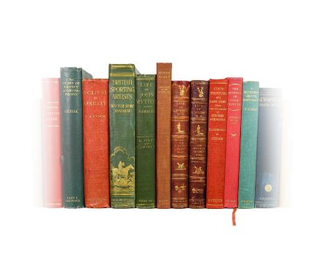
Lot 53
Gilbey (Sir Walter). Life of George Stubbs R.A, 1st edition, number 42 of 150 copies only, London: Vinton & Co., 1898. 4to (248 x 186 mm), original dark red morocco rebacked with original spine laid down, sporting vignettes gilt to front cover, all plates as called for, bookplate of Thomas Guy Paget (1886-1952), soldier, Conservative politician and author of Sporting Pictures of England (1945) - ibid. Farm Stock 100 Years Ago, 1st edition, London: Vinton & Co., 1910. 8vo, original pictorial orange cloth gilt, inscribed by the author 'T B Wood, with compliments, 5th May 1910, Walter Gilbey' on the title-page, a little wear to extremities - Nevill (Ralph). Old English Sporting Books, 1st edition, number 508 of 1500 copies only, London: The Studio Limited, 1924. 4to, original red pictorial cloth over bevelled boards, dust jacket, all plates as called for, spine sunned, dust jacket with a few chips and nicks - [Apperley, Charles James]. Nimrod's Hunting Tours ... A New Edition with an Introduction by W. Shaw Sparrow, London: John Lane The Bodley Head, 1926. 4to (251 x 182 mm), modern red half morocco, top edge dyed red, others untrimmed, all plates as called for (including folding map of Leicestershire) - and 11 others on field sports and sporting art, including another copy of Gilbey, Life of George Stubbs, 1898, number 76 of 150 copies only (lacking plate facing p. 142) (qty: 15)
![Marshall (William). The Rural Economy of Norfolk, 2nd edition, London: for G. Nicol [and others], 1795. 2 volumes, 8vo (210 x](https://cdn.globalauctionplatform.com/64361b91-8ff9-4015-9611-ad160112fc1d/bcfe3591-8bcc-4e49-8423-ad570109356e/468x382.jpg)
Lot 58
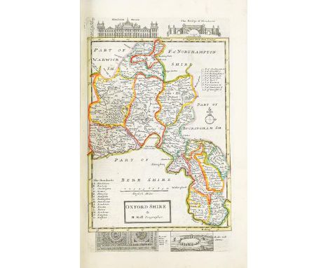
Marshall (William). The Rural Economy of Norfolk, 2nd edition, London: for G. Nicol [and others], 1795. 2 volumes, 8vo (210 x 122 mm), near-contemporary tan half calf, engraved folding map, loss to one spine-label - ibid. The Rural Economy of Yorkshire, 2nd edition, London: for G. Nicol [and others], 1796. 2 volumes, 8vo (206 x 126 mm), near-contemporary tan half calf, 2 engraved folding maps, advertisement leaf to volume 1 spines scuffed, loss to one label, joints rubbed and partially cracked, volume 2 half-title discarded, spotted towards rear - Tuke (John). General View of the Agriculture of the North Riding of Yorkshire, 2nd edition, London: B. McMillan, 1800. 8vo (202 x 120 mm), modern dark green half morocco gilt by Bayntun, half-title, folding hand-coloured map, 14 engraved plates, folding letterpress table - Brown (Robert). General View of the Agriculture of the West Riding of Yorkshire ... Drawn up for the Consideration of the Board of Agriculture and Internal Improvement, Edinburgh: for James Watson, 1799. 8vo (208 x 120 mm), marbled boards, rebacked, engraved folding map - [Thompson, Thomas]. Ocellum Promontorium; or, Short Observations on the Ancient State of Holderness. With Historic Facts Relative to the Sea Port and Market Town of Ravenspurne, 1st collected edition, Hull: Thomas Topping, 1824. 2 parts in 1 volume, 8vo (230 x 136 mm), recent quarter cloth, engraved folding map and additional title-page, 5 engraved plates (collation not established) - together with 8 others similar (not collated), including Bailey and Culley, General View of the Agriculture of the County of Northumberland, 3rd edition, 1805, Arthur Young, The Farmer's Calendar, 10th edition ('greatly enlarged'), 1815, Eastmead, Historia Rievallensis: Containing the History of Kirkby Moorside, 1st edition, 1824, and others (qty: 15) ESTC T72783 (Marshall, Norfolk), T123051 (Marshall, Yorkshire), T40693 (Tuke), N30551 (Brown, nine copies world-wide).
Lot 6
Moll (Herman). A Set of Fifty New and Correct Maps of England and Wales, etc. With the Great Roads and Principal Cross-Roads, etc. Shewing the Computed Miles from Town to Town, London: sold by H. Moll; Tho. Bowles, J. Bowles, 1724. Folio (357 x 230 mm), contemporary panelled calf, letterpress title-page, 50 engraved maps (including 2 general maps, both folding), all hand-coloured in outline, the county maps including engraved vignettes of local antiquities in margins, contemporary ownership inscription (Eliz[abe]th Wallace) and later bookplate (Christopher Coleman Gill) to front pastedown, binding worn, front board detached (together with front free endpaper and initial blank), rear joint cracked, browning to letterpress title-page and the 2 general maps, map of Cornwall slightly toned and mottled along edges (qty: 1) Chubb CLXI. First separate edition of the maps from Herman Moll's A New Description of England and Wales, published the same year; the only change is that the maps are now numbered between brackets in the top-left corner. According to Chubb the maps were uncoloured.
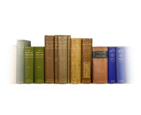
Lot 62
Nelson (Thomas H.). The Birds of Yorkshire, 1st edition, London: A. Brown & Sons, Limited, 1907. 2 volumes, 8vo, original green cloth, colour frontispieces and titles-page, half-tone photographic plates, errata slip to volume 1, occasional spotting to text-blocks - [Grouse]. The Grouse in Health and Disease. Being the Final Report of the Committee of Inquiry on Grouse Disease, 1st edition, London: Smith, Elder & Co., 1911. 2 volumes, 4to, original cloth, volume 1 with 59 plates numbered 1-58, volume 2 with colour map (and maps in text), volume 1 with light mottling to covers and fraying to headcaps, volume 2 text-block spotted - Burrard (Gerald). The Modern Shotgun, 1st edition, London: Herbert Jenkins Limited, 1931-2. 3 volumes, 8vo, original blue cloth, all halftone photographic plates as called for, text-blocks toned and occasionally spotted - and 14 others (not collated), field sports, early 20th-century, original cloth, including another copy of The Grouse in Health and Disease, Pollard, A History of Firearms, 1930 (first edition 1926), Duncan & Thorne, The Complete Wildfowler, 1911 (with dust jacket), and similar (qty: 25) Mullens & Swann p. 432 (Nelson).
![Morden (Robert). Four county maps, [London]: Abel Swale, Awnsham and John Churchill, [1695 or later], comprising Darbyshire [](https://cdn.globalauctionplatform.com/64361b91-8ff9-4015-9611-ad160112fc1d/9de33cbe-3732-4cb6-af9c-ad57010918c6/468x382.jpg)
Lot 7
Morden (Robert). Four county maps, [London]: Abel Swale, Awnsham and John Churchill, [1695 or later], comprising Darbyshire [sic], Staffordshire, Herefordshire, and Episcopatus Dunemensis vulgo the Bishoprick of Durham, each an engraved map hand-coloured in outline (approx. 435 x 370 mm), separately framed and glazed, Durham and Staffordshire spotted, Darbyshire closely trimmed and with short split to foot of central fold (qty: 4)

Lot 8
Ogilby (John). The Continuation of the Road from London to Barwick, beginning at Tuxford and extending to York. Plate 3d ... From Tuxford to Bawtre ... Doncaster ... Wentbridge ... Tadcaster ... York, [and:] The Continuation of the Road from London to Barwick beginning at York and extending to Chester in ye Street. Plate ye 4th ... Burrowbridge ... to Topcliff ... Northallerton ... Darlington ... Durham ... Chester in ye Street, [1675 or 1698]. 2 hand-coloured engraved strip road maps, somewhat browned, separately mounted, framed and glazed, mount apertures 345 x 466 mm, together with: Saxton (Christopher). Eboracensis comitatus pars septentrionalis vulgo North Riding [of Yorkshire]. Gulielmus Hole sculpsit, [1607]. Hand-coloured engraved map, mounted, framed and glazed, mount aperture 210 x 362 mm (qty: 3) Cf. Chubb C-CIIa (Ogilby) and XVIII (Saxton; the map is from William Camden's Britannia).


Lot 323
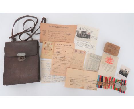
WW2 Polish/French Map Case and Owner's Medals and Paperwork all relating to "Lieutenant W Skierski". Consisting rectangular, brown leather case. Front pocket with top secured flap. Rear opening flap with compass and pencil pockets. Leather shoulder strap. Together with his WW2 medal group consisting 1939-45 Star, Africa Star, Italy Star, Defence medal and 1939-45 War medal in postal box named to "Major W Skierski. Polish Resettlement Corps" ... His "Armee Polonaise En France" ID card ... Photo of him in a Polish group dated 1934 ... Various paperwork and photos. Good Polish orientated collection.
Lot 183
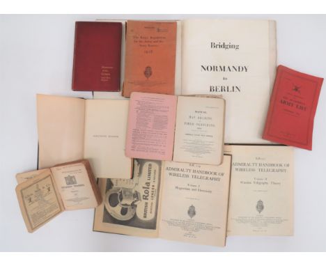
Variety of Pre 1950's Books consisting Haileybury College Register 1862-1946 ... King's Regulations For The Army And The Army Reserve 1928 ... Infantry Training Vol 1 1932 ... Manual Of Map Reading And Field Sketching 1912 ... Army Quarterly List Dec 1948 ... Handbook Of Wireless Telegraphy 1938 Vol 1 & Vol 2 ... Bridging Normandy To Berlin (some damage). 9 items.


-
109198 item(s)/page