We found 109182 price guide item(s) matching your search

Refine your search

Year

Filter by Price Range
  • List
  • Grid
  • 109182 item(s)
    /page

Lot 233

Original vintage travel advertising poster for express services between London - Bristol - Weston-Super-Mare by Greyhound & Royal Blue Services. The poster features a colourful illustration of a simplified map of the Weston-Super-Mare route to London and two men holding birds, red bearded man wearing a sailors hat is holding a green and red parrot, white bearded man wearing blue hat is holding a pigeon. Royal Blue Express Services was a coach operator in the south and west of England from 1880 until 1986. Very good condition, creasing. Country of issue: UK, designer: Daphne Padden, size (cm): 76x51, year of printing: 1967.

Lot 255

Original vintage travel poster National Parks North York Moors, featuring a map of the area, with images showing fishing, cycling and walking activities, Mauley Cross, Laurence Sternes house, Helmsley Castle, Rievaulx Abbey, Hole of Horcum, Robin Hood's Bay, with the legend showing roads, railways, youth hostels, places of historic or literary interest, crosses, fishing, boating and sailing activities, waterfalls, and golf. Prepared for the Countryside Commission by the Central Office of Information. Printed in England by Her Majesty's Stationery Office Press, Manor Farm. Good condition, creasing, tears. Country of issue: UK, designer: Reitz, size (cm): 76x50, year of printing: 1970.

Lot 256

Original vintage travel poster National Parks North York Moors, featuring a map of the area, with images showing fishing, cycling and walking activities, Mauley Cross, Laurence Sternes house, Helmsley Castle, Rievaulx Abbey, Hole of Horcum, Robin Hood's Bay, with the legend showing roads, railways, youth hostels, places of historic or literary interest, crosses, fishing, boating and sailing activities, waterfalls, and golf. Prepared for the Countryside Commission by the Central Office of Information. Printed in England by Her Majesty's Stationery Office Press, Manor Farm. Very good condition, creasing. Country of issue: UK, designer: Reitz, size (cm): 76x50, year of printing: 1970.

Lot 270

Original vintage travel poster - Historical Map of Ireland- Design by the decorative map maker Leslie George Bullock (1895-1971), featuring a map of the Republic of Ireland and Northern Ireland with illustrations of historical Irish landmarks, travel routes, historical events, battles, notable figures, famous ships, cathedrals, abbeys, castles, resorts, towns and citys. Framing the map of Ireland are several coats of arms for Irish counties and universities. Printed by John Bartholomew and Son LTD. Good condition, creasing, staining, glossy varnish finish. Country of issue: UK, designer: Leslie George Bullock , size (cm): 97x64, year of printing: 1985.

Lot 272

Original vintage travel poster - Historical Map of England and Wales - Design by the decorative map maker Leslie George Bullock (1895-1971), featuring a map of England and Wales with illustrations of historical English and Welsh landmarks, travel routes, historical events, battles, notable figures, famous ships, cathedrals, abbeys, castles, resorts, towns and citys. Framing the map of England and Wales are several coats of arms for English and Welsh counties and towns. Printed by John Bartholomew and Son LTD. Good condition, creasing, staining, glossy varnish finish. Country of issue: UK, designer: Leslie George Bullock , size (cm): 97x66, year of printing: 1985.

Lot 273

Original vintage London Transport poster commissioned in 1987 as part of the Art on The Underground series - The Tate Gallery by Tube - featuring an illustration of the colourful tube map lines as paint from a tube marked with the London Underground logo. Good condition, creasing, small tears, minor staining. Country of issue: UK, designer: David Booth, size (cm): 76x51, year of printing: 1987.

Lot 276

Original vintage sport poster for a golfing event at the Island Club in Singapore: "Exhibition Golf Match Island Club 6 1/2 Mile Thomson Road 3pm Saturday 29th January. Von Nida will play an 18 hole Exhibition Match with Jack Hodgkinson (Island Club Singapore) followed by a short demonstration of various golf shots." Great design in blue and white featuring the notable Australian golfer Norman Von Nida (Norman Guy Von Nida; 1914-2007) in a swing stance with his club raised ready to strike a golf ball with a kangaroo on the left and a map of Australia in the background, the text below in stylised blue and red letters. The Golf Club was opened in Singapore in 1891 (now the Singapore Island Country Club); Jack Hodgkinson joined the Club in 1937 and retired as Club Secretary in 1959. Good condition, staining, creases and folds in margins. Country:Singapore. Year:1949. Designer:Theo. Size (cm):56x38

Lot 36

Original vintage advertising poster for National Swiss Explorers Camp / Campo Nazionale Esploratori Svizzeri in Lugano Trevano from 26 July to 4 August 1948, featuring an image of a smiling boy scout in a uniform, big hat and a backpack appearing from the tear in the map of Switzerland. Fair condition, folds, tears, pinholes, staining, creasing, paper losses. Country of issue: Switzerland, designer: S. Zulliger, size (cm): 100x70, year of printing: 1948.

Lot 379

Original vintage anti-nuclear propaganda poster Live In A Nuclear-Free Zone featuring a photomontage by the English political artist Peter Kennard (b. 1949) depicting a green outline of the United Kingdom map with a grey peace symbol around it, white lettering set over a black background. The 1980s saw a rise in the Nuclear-free zone movement in the UK, with authorities including county, district and city councils declaring themselves nuclear-free, and refusing to take part in civil defence exercises relating to nuclear war. Generally, nuclear-free zones were predominantly Labour Party-controlled councils but the Liberal Party and even a few Conservative Party councillors were often active in this respect too. This has been seen as a victory for the British Peace movement against the policies of Margaret Thatcher. Good condition, folds, crease marks, pinholes. Country of issue: UK, designer: Peter Kennard, size (cm): 42x30, year of printing: 1983.

Lot 392

Original antique World War One poster published by Ligue Maritime Francaise French Maritime League - Les Realites de la Guerre Sur Mer / The Realities of War at Sea - featuring an illustration of marine vessels including ships and submarines and a map of the world, the captions compare Central Powers and Antante in aspects of the tonnages of marine vessels, used seas, the tonnage of sunk vessels, the tonnage of built vessels, and sunk German submarines. Good condition, folds, creasing, tears, pinholes, paper loss in top right corner. Country of issue: France, designer: L. Haffner, size (cm): 62x51, year of printing: 1918.

Lot 400

Original vintage World War Two anti-British propaganda poster - Have Confidence ... The Systematic Amputations Continue Methodically / Confiance ... Ses Amputations Se Poursuivent Methodiquement - issued by the Vichy Government in occupied France and featuring an image of the British leader Winston Churchill as an octopus with his tentacles around parts of a map representing British military intervention around the world, the cutting of these tentacles dripping with blood reflecting the prevention of British actions in Norway, Germany, Syria, Somalia, Libya, Mers el Kebir and Dakar by the Axis forces. Large size. Good condition, creasing, folds, repaired tears, minor staining. Country of issue: France, designer: SPK, size (cm): 120x80, year of printing: 1942.

Lot 403

Original vintage World War Two poster - Schematic Map of Poland - Issued in 1944 by the Polish Army in the East and showing Poland on a map using a red border. Very good condition, small tears, creasing. Country of issue: Poland, designer: Unknown, size (cm): 61.5x50, year of printing: 1944.

Lot 414

Original vintage World War Two poster Pacific Arena A Fortune Map Orthographic Series II drawn by Richard Edes Harrison assisted by Marjorie K. Ulrich, supplement to Fortune September 1942, Copyright 1942 Time Inc., featuring an image of a globe showing the Pacific Ocean area with Australia, New Zealand, Japan, China, South East Asian countries and the countries of Oceania, with articles on Japanese Strategy, American Opportunity, smaller images with the legend, and the other half of the globe. Horizontal. Good condition, folds, tears, creasing, staining, paper losses on edges. Country of issue: USA, designer: Richard Edes Harrison, size (cm): 54x68, year of printing: 1940s.

Lot 415

Original vintage propaganda poster - The Duties of the British Navy are Global - featuring an image of the world with the red line showing the navy routes, the text below in Arabic roughly translates to English - This map shows the importance of the main sea routes to the United Peoples and how the Royal Navy controls these routes and deprives the Axis powers of benefiting from them and importing vital war supplies. The lines show the main trade routes and show the huge distances that must be travelled. More than 80,000 miles of navigation routes are constantly patrolled. 80% of Britain’s military production is transferred to the fields. Overseas combat - constantly guarding British and Allied ships. The enemy lost more than 125 warships and more than 60,000,000 tons of commercial ships by being sunk, severely damaged, or looted. The length of navigation routes that clear mines increases. Cutting off the enemy’s maritime trade, including the import of vital war materials. Guarded naval convoys that made more than 1,200,000 trips using + British warships and British Royal Air Force aircraft. 199 ships arrived safely out of every 200 ships. There are 600 British warships and ships attached to them permanently at sea. Some of them have travelled a distance equivalent to the length of the distance around the Earth nine times. Good condition, folds, creasing, pinholes, small tears. Country of issue: UK, designer: Unknown, size (cm): 76x50, year of printing: 1940s.

Lot 96

A German WWII leather map case.

Lot 287

Local aviation aeronautical history interest - RAF Colerne including an airfield crash map relating to the Sept 1973 Lockheed C-130 Hercules crash resulting in five fatalities; a German helmet, overalls, sqd scarf, flag, a cockpit lamp from H.P. Hastings, an igni

Lot 97

Three attractive signs for Southdown and Express Service, a London to Eastbourne sign, an Underground map etc. (6)

Lot 94

A very large map of Africa, 1669 design, well framed, 72 3/4 x 53".

Lot 1109

An engraved county map of Middlesex for “Moule's English Counties,” by W. Schmollinger, with inset illustrations of Buckingham Palace and Westminster, circa 1830s; together with one other for Surrey, and a small quantity of unframed but mounted topographical engravings (6)

Lot 103

Margary, Harry; A collection of early maps of London 1553-1667, introduction by John Fisher, in association with Guildhall Library London 1981; together with a large accurate map of the City of London, London actually surveyed and a prospect of London and Westminster taken at several stations to the southward thereof, an exact survey of the Cities of London Westminster the Borough of Southwark and the Country near 10 miles round London, edited by Harry Margery; together with other volumes to include the A to Z of Georgian London and the A to Z of Restoration London

Lot 120

Marshall, Prince; Wheels of London, the story of London's street transport, limited edition No. 1029 / 3000, in cardboard box with Wheels of London collectors cards and reproduction London Transport tickets and map; together with one other numbered 2271 / 3000 (2)

Lot 265

A Framed map of the Isles of Shetland & Orkney [60x47cm]

Lot 50

The Royal Geographical Society Silver Map 1976 Limited edition The Franklin Mint measures approx 28 inches wide by 20 tall

Lot 233

A silk embroidered map of England

Lot 2125

A Print of Map of Caernarfon, Merioneth, Angelsea; after Michael Drayton.

Lot 2126

A small framed, Van De Keen map of Nottinghamshire, after Speed 1627.

Lot 701

A 1940s cloth map of the Congo Forest

Lot 1085

A large 1876 Map of Railway and Stations in Gloucestershire by Morris & Co., 23 1/2'' x 28''.

Lot 1141

A Map of the county of Salop engraved by J & C Walker, frame 31 3/4" x 31 3/8".

Lot 1143

A large folder containing a large Ordnance Survey map of Trewyn Manor and adjoining estates, The Property of J.L. Rosher Esq.

Lot 1173

A quantity of miscellaneous maps including; OS maps of Pembrokshire, Somerset, 1872 map of The Isle of Wight, Homelink maps of Scotland, etc.

Lot 1174

A small quantity of miscellanea to include; an OS Geographical War Revision map from 1940 of Abergavenny, The Illustrated London News, Silver Jubilee 1910-35, a poster and chart of valve and ignition timings 1934-47, graph paper, etc.

Lot 45

Donald Shearer, signed print, "The Old Course St. Andrews", together with a map of the course, both framed 

Lot 670

A wall hanging Middle East and India map by Georg Westerman Veriag Braunschweig Germany 193cm x 162cm

Lot 671

A wall hanging of Mediterranean and Middle East map by Georg Westermann Veriag Braunschweig Germany 280cm x 155cm

Lot 122

A Richard Blome map of Yorkshire, 12.5" x 10.5" centre crease, together with a facsimile map of Essex after Norden, and a map of Carmarthenshire after Thomas Kitchin

Lot 152

A Robert Morden map of Dorsetshire, 14" x 17", centre crease

Lot 158

Engraved map of Dorsetshire and a similar of Cornwall engraved by Sidney Hall

Lot 63

George Richard Deakins, seascape with boats, signed, 23cms x 100cms together with another similar by the same artist, A coloured map of Dorset, another small map and a watercolour by Hamilton Glass

Lot 116

COLLECTION 'DISMALAND' EPHEMERA, including 2 stencilled cardbaord fragments, 2 defaced $1 bills, defaced stamp, map/plan of the site, canvas tote bag, photograph, canvas stencilled picture etc. (10)Provenance: private collection CardiffComments: some collected on site, none authenticated, some framed, glass in one frame damaged..

Lot 118

ROBERT MORDEN coloured antique map 'South Wales', 35 x 43cms (framed and glazed); together with coloured engraving entitled 'The British Association - Swansea, August 1880', 34 x 50cms (2)Provenance: private collection Swansea, by descent

Lot 21

An Ordnance Survey one inch map for Land's End & Lizard - fifth edition, together with Bartholomew's map of Cornwall, Bacon's map of Scotland, an illustrated map of the Nile and an Enid Blyton novel.

Lot 300

An Interesting Collection of Ephemera, including: colour advertisements; engravings taken from books, including birds, maps, portraits; British Railways cigarette cards; London Transport map for the day of Elizabeth II's coronation; pamphlets relating to York; two folders of colour greetings telegrams, 20th century, etc.; in 11 folders/box files; with two hand-tinted framed portrait photographs (1 box)

Lot 310

Mary, Princess Royal, Signed Portrait Photograph, dated 1934, signed "Mary", framed and glazed; together with a map: The Whole Turkish Empire, no date, outline colouring, mounted, framed and glazed.

Lot 1006

A framed gem set "Map of the World" in case, 34cm x 46cm

Lot 321

An assortment of vintage prints, etchings, ephemera, a map (not all photographed) etc

Lot 412

Collection of three maps to include: John Speed, Merionethshire Described, Thomas Bassett & Richard Chiswell, hand coloured map described 1610 with text to back, John Speed, Caermarden Both Shyre and Towne Described 1610, John Sudbury & George Humble (A/F) along with one other

Lot 767

A collection of vintage maps including a 1939 War Office revised map of China and its territories, military maps, Daily Telegraph's war map, Stanford's map of the world etc.

Lot 136

Tolkien (J.R.R.) The Lord of the Rings, 3 vol., first editions, first impressions, The Return of the King with signature mark '4' and text block sagging, folding map at end of each vol., ink gift inscription in the year of publication on each front free endpaper, light tape staining on endpapers, The Two Towers endpapers with light toning strip, original cloth, fine, dust-jackets, very light scuffing to corners, jacket spine lightly creased, otherwise a bright, crisp, and near-fine set, [Hammond & Anderson A5], 8vo, 1954-55.

Lot 142

Waugh (Evelyn) Remote People, first edition, folding map, light spotting to edges, endpapers toned, original boards, dust-jacket, light surface marking, corners lightly chipped, spine head a little creased, [Davis 7], 8vo, 1931.

Lot 145

Waugh (Evelyn) Ninety-Two Days, first edition, folding map and illustrations, dust-jacket, light surface soiling, extremities and corners chipped and nicked, 1934; Labels, cloth spine faded, [Davis 10], 1930, first editions, original cloth, 8vo (2) *** First edition of Waugh's third travel book, in the rare jacket. It chronicles a 92-day expedition across Latin America, illustrated with Waugh's own photographs. Grouped together with Waugh's first travel book Labels. 

Lot 149

Waugh (Evelyn) Black Mischief, first trade edition, signed by the author on title, map frontispiece, pencil ownership inscription to endpaper, original cloth, slight shelf-lean, light toning to spine, 2 short splits to head of spine, light rubbing to extremities, spine browned, spine ends and corners a little chipped, light rubbing to extremities, but an excellent copy overall, 8vo, 1932. *** Black Mischief was published in both trade and limited editions, with the latter used by Waugh in part for presenting as gifts. As a result, the first trade edition is one of the most difficult of Waugh's titles to find signed.

Lot 157

Games.- Spooner (William) The Travellers; or, A Tour Through Europe, hand-coloured lithograph map of Europe including vignettes of cities & people or animals typical of the region, c.505 x 630mm., dissected and mounted on linen, a little soiled and stained, slight fraying to lower edge and to edges & corners of sections, a few splits to folds, folding into original cloth folder with lithographed pictorial label to upper cover, rather worn and stained, [Whitehouse p.18], 1842 § New Royal Game of Goose (The), hand-coloured lithographed sheet depicting a goose containing 63 numbered circles, some containing illustrations including a railway station, a train and the Crystal Palace, with rules in box above and border with ornamental corners, c.435 x 545mm., lightly browned, folding into original board folder with hand-coloured illustration to upper cover, rubbed, [Whitehouse p.69], n.p., [c.1855] § Jeu du Nain Jaune/Jeu de Bog, 2-sided game, 6 folding conjoined triangular shapes which when unfolded form a hexagon with a circle cut out of the middle, c.375 x 430mm., lithographed sheets mounted on both sides of board forming 2 games, each with title and 5 hand-coloured playing cards including Knave, Queen & King (Nain Jaune with Lancelot, Palais & Charles, Bog with Lancelot, Rachel & David), 2 sheets of Nain Jaune a little rubbed and soiled, Paris, [c.1860] § Hammer- und Glockenspiel, 5 hand-coloured engraved sheets mounted on thick card (Hamer, Glogge, Kaufthaus, Hamer und Glogge, Schimel), each c.130 x 90mm., rather soiled, one creased from folding, together with letterpress sheet of rules (creased and wormed with loss of a few letters) in original marbled board slip-case, rubbed, [Austria/Germany], [c.1825]; and a copy of De La Rue's portable chess & draught board (designed by Owen Jones) with removable 2-sided pieces tucked into slots (1870s), v.s. (5)

Lot 181

West Indies.- Johnson (Col. John, Lieutenant-Governor of Nevis) An Historical and Descriptive Account of Antigua..., title, errata slip, the large folding map 'A New & Improved Map of the Island of Antigua, in the West Indies. Constructed and drawn chiefly from original Materials and most Recent Surveys. By J. Johnson', 11 pp. of historical accounts of Antigua, lithographed vignette title 'Part the Second' with two lithographed maps, and some text only, without any aquatint plates, spotting and browning throughout, some heavy, the folding map with bright hand-colouring, dissected and mounted on linen, with damp-staining to sheets towards the end and elsewhere, front-free endpaper detached, loose, contemporary calf with upper cover gilt, upper cover detached and loose, lacking spine, boards very worn, oblong folio, printed by Henry Baylis for the author, 1830. 

Lot 182

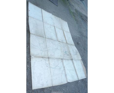
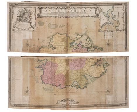
West Indies.- Wilkinson (Robert) Atlas of the West-Indies, composite atlas with manuscript title and contents, 28 engraved maps and charts on 32 sheets, with four maps divided into North and South sheet sections, all with hand-colouring, many folding, various sizes between 490 x 620 mm (19 1/4 x 24 3/8 in) and the largest single map approx. 1640 x 940 mm (64 1/2 x 37 in), all with discolouration and browning to green copper pigment used, some splitting to old folds, numerous handling creases throughout, rather heavy surface dirt, half calf, spine with title 'Atlas of West Indies', elephant folio (595 x 530 mm), [circa 1795-1815]*** Important publisher's composite atlas with numerous large and early maps of the West Indies, including:- Delarochette (Louis) A Map of North America and the West Indies, engraved map in two sections, [1795-1825] - Speer (John Joseph) A General Chart of the West Indies, engraved map, 1796- Lempriere (Charles) [Sea Chart of Bermuda], engraved map, 1738 [but probably later]- Jefferys (Thomas) Three sheets from the 'West India Atlas' [covering the Coast of Yucatan, Island of Cuba, and the Windward Passage], engraved map, [c. 1775 or slightly later]- Browne (Patrick) A New Map of Jamaica, engraved map, 1797- Faden (William) Isle of St. Domingo or Hispaniola, engraved map, 1796- Laurie & Whittle Turks Islands, engraved map, 1794- Richmond (M.) A Map of the Caribbee, Granadilles and Virgin Isles, 1789- Jefferys (Thomas) The Virgin Islands from English and Danish Surveys, 1794- Faden (William) The Island of St Eustatius corruptly St Eustatia, 1795- Baker (Samuel) A New and Exact Map of the Island of St. Christopher in America, 1753- Baker (Robert) A New and Exact Map of the Island of Antigua in America, 1748- Jefferys (Thomas) Guadaloupe Done from Actual Surveys and Observations of the English, 1794- Jeffreys (Thomas) Martinico, 1794- Jefferys (Thomas) St. Lucia, 1794- Mayo (William) A New and Exact Map of the Barbadoes in America- Byres (John) ... His Majesty's Island of Dominica ..., 1794- Byres (John) Plan of the Island of Bequia, 1776 [but 1794]- Paterson (Lieut. Daniel) A New Plan of the Island of Grenada, 1796- Byres (John) Plan of the Island of Tobago, 1794- Delarochette (Louis) The Coast of Guyana, 1783- Anderson (John) Chart of the River and Sea Coast of the Colony of Demerary..., - Jefferys (Thomas) Curacao from the Dutch Originals..., c. 1795- Jefferys (Thomas) Ruatan or Rattan..., 1794- Faden (William) A Map of a Part of Yucatan or of that Part of the Eastern Shore within the Bay of Honduras Alloted to Great Britain for the Cutting of Logwood, 1787- Kitchin (Thomas) South America with Its Several Divisions, 1794 

Lot 207

World.- Crane (Walter) Imperial Federation, Map of the World showing the extent of the British Empire in 1886, printed to coincide with the Colonial and Indian Exhibition of 1886, lithographic map printed in colours, sheet 615 x 820 mm (24 1/4 x 32 1/4 in), old folds, some expert repairs to tears, mainly visible verso, otherwise minor toning, unframed, published as a supplement to The Graphic, London, Maclure & Co., 24 July 1886. 

Lot 208

Channel Islands.- Falle (Philip) An Account of the Isle of Jersey, first edition, half-title, previous owner's ink inscriptions to half-titles, engraved diagrams, engraved folding map hand-coloured in outline, 2 short tears at gutter with old tape repairs verso, short marginal tear with small loss to foot K1, publisher's advertisements at end, modern antique style panelled calf, gilt, for John Newton, 1694; Histoire détaillée des Isles de Jersey et Guernesey, first French edition, 2 folding engraved maps, short tears at gutter with old tape repairs verso, engraved diagrams, previous owner's inscription to front pastedown and front free endpaper verso, occasional faint spotting, later calf-backed boards, slight rubbing to corners, Paris, 1757; 8vo & 12mo (2) *** Provenance: Both inscribed to or by Rear Admiral John Saumarez Dumaresq (1873-1922). The Dumaresq family was a patrician family in the Channel Islands, with a particular interest in Jersey. Each volume contains a map drawn from a survey by Philip Dumaresq. On the accession of King James II, Philip Dumaresq presented him with an account of the Channel Islands and suggestions for their defence. 

Lot 209

London.- Cary (John) Cary's New and Accurate Plan of London and Westminster, the Borough of Southwark and parts adjacent..., large detailed map with an alphabetical list of upwards of 500 of the most principal streets with references to their location on the map, hand-coloured engraved map, 820 x 1525mm., dissected and mounted on linen, lightly browned, small stain to top left corner at edge, split to one fold, folding into marbled board slip-case with printed label to upper cover, rubbed and worn, tall 8vo, 1815. *** Showing London at the end of the Regency period of George IV. The map had to be extended in 1811 to accommodate the development of Docks on the Isle of Dogs and here in 1813 to show Regent’s Park and the Regent’s Canal moving eastwards.

Lot 211

London.- Horwood (Richard) Plan of the Cities of London and Westminster the Borough of Southwark and Parts adjoining Shewing every House, large bound wall map of London, composite collection from the first and second editions, 23 sheets only (of 32, lacking sheets A4, B2-B3, C2, D2, E3-E4, F3-F4, G3-G4, H3-H4), presented on a scale of twenty-five inches to the mile, extending from Angel to Limehouse, and Kennington to Brompton, engravings on various cream wove papers, some with watermarks 'Horwood's Map of London', each individual sheets approx. 560 x 650 mm (22 x 25 1/2 in), or smaller with some sheets trimmed, some on stubs, some loose, scattered surface dirt, occasional nicks to extremities, later half calf, covers detached, lacking spine, manuscript inscription to upper cover, very worn, elephant folio, [cf. Howgego 200], [c.1792-1807]*** The largest map printed in Georgian Britain, and a defining study of London at the end of the eighteenth century. Horwood's plan was the first map of London to attempt to show every individual property, and took over 7 years to complete following numerous logistical and financial obstacles.

Lot 217

Astronomy.- Maupertuis (Pierre-Louis Moreau de) La Figure de la Terre..., first edition, 1 engraved map and 9 plates, all folding, printer's device to title, contemporary mottled calf, small tears to lower cover edge, and a little rubbed elsewhere, 8vo, Paris, l'Imprimerie Royale, 1738.*** First edition of this famous work on the applanation of the earth at the poles; Maupertius headed the scientific expedition to Lapland, with the objective to confirm Newton's theory of the flattening of the earth at the poles, with the results proving fatal to the Cassinian hypothesis. 

Loading...Loading...
  • 109182 item(s)
    /page

Recently Viewed Lots