We found 109198 price guide item(s) matching your search
There are 109198 lots that match your search criteria. Subscribe now to get instant access to the full price guide service.
Click here to subscribe- List
- Grid
-
109198 item(s)/page


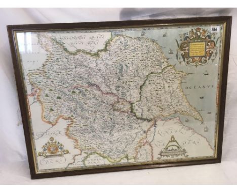
Lot 154
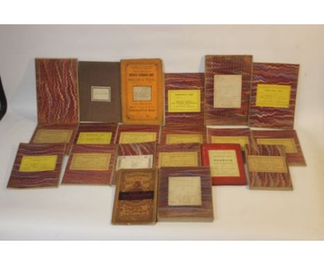
ANTIQUARIAN STAFFORDSHIRE INTEREST BOOKS to include 'History, Gazetteer and Directory of Staffordshire...' by William White 1834, 'A Topographical and Historical Description of the County of Stafford....' by Rev. Mr Nightingale (includes map & engravings), 'A Survey of Staffordshire....' by Sampson Erdeswick 1844, and 'A Topographical History of Staffordshire' by William Pitt (lacking title pages) (4)

Lot 158
STAFFORDSHIRE INTEREST BOOKS - a tray to include 'History of Wetton, Thor's Cave, and Ecton Mines' by James Roberts 1900, 'The History of Calwich Abbey' by Mary Teresa Fortescue (inscription dated 1914), 'Researches into the History of the Parish and Parish Church of Stone, Staffordshire' compiled by Bowers & Clough, 1929, 'History and Antiquities of the Town and Neighbourhood of Uttoxeter' by Francis Redfern 1886, 'Bacon's New Survey Map of Staffordshire & Shropshire', etc.

Lot 164
MEMORIALS OF SHREWSBURY SCHOOL with views of the most interesting features of the school as well as some of the most familiar scenes in the town and neighbourhood: Drawn from nature, on stone by C. W. Radclyffe, Esq. printed in tinted lithography by Day and Haghe. Shrewsbury: published by Sandford & Howell, 25 High Street, 1844, has various additions in the form of newspaper cuttings, leaflets, map, extra prints, handwritten notes etc.
Lot 185
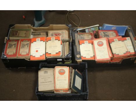
A SMALL COLLECTION OF FOLDING MAPS MAINLY LINEN BACKED ORDNANCE SURVEY to include 1:2500, 1:63360, various areas together with W. H. Smith & Son's reduced Ordnance Map of Norwich and Environs, Scale 4 miles to an inch, and Cruchley's Reduced Ordnance Map of Cornwall (20)1:63660 maps are sheet numbers 78, 84, 94 and 186


Lot 198
EDWARD STANFORD FOLDING MAP OF 'THE DANUBIAN PRINCIPALITIES prepared from the Vienna Map in 21 sheets', c.1857, a linen backed dissected map with 48 sections and in one piece, not split into two. Size is 142 x 137 cm. The Danubian Principalities covered the area of Moldavia and Wallachia which is now Romania, the map also covers Bulgaria. There is no cover or slipcase.

Lot 3
Charles Smith (publisher) - 'Smith's New Map of the Navigable Canals and Rivers of England, Wales & Scotland', engraving in 20 sections, hand-coloured in outline, folded and backed onto linen, circa 1827, overall 98cm x 80cm, within a cardboard case with original paper label.This lot is subject to a Buyer’s Premium of 24.5% (including VAT @ 0%) of the hammer price. Purchased online via the-saleroom.com, this lot will attract an additional premium of 5% (including VAT @ 0%) of the hammer price.

Lot 11
James Wyld (publisher) - 'A New Map of the County of Sussex', engraving in 56 sections hand-coloured in outline, folded and backed onto linen, published by James Wyld circa 1831, overall 93cm x 211cm, within a cloth covered cardboard case.This lot is subject to a Buyer’s Premium of 24.5% (including VAT @ 0%) of the hammer price. Purchased online via the-saleroom.com, this lot will attract an additional premium of 5% (including VAT @ 0%) of the hammer price.

Lot 7
George C. Ashmead (publisher) - 'Plan of Bristol and its Suburbs, reduced from the original survey of the late J. Plumley, with additions by Geo. C. Ashmead', engraving in 18 sections, folded and backed onto linen, circa 1833, overall 64cm x 79cm, within cloth covered boards, together with William Lander's 'Electoral District Map of the City and County of Bristol', engraving, hand-coloured in outline in 18 sections, folded and backed onto linen, published circa 1840, overall 61cm x 50cm, within cloth covered boards.This lot is subject to a Buyer’s Premium of 24.5% (including VAT @ 0%) of the hammer price. Purchased online via the-saleroom.com, this lot will attract an additional premium of 5% (including VAT @ 0%) of the hammer price.

Lot 5
F. Bryer (engraver) - 'Sussex' (Map of the County), engraving in 24 sections, folded and backed onto linen, published by Kelly & Co, Post Office Directory Office, circa 1887, overall 66cm x 100.5cm, within a cloth covered cardboard case with gilt title, together with a folding map of East Sussex.This lot is subject to a Buyer’s Premium of 24.5% (including VAT @ 0%) of the hammer price. Purchased online via the-saleroom.com, this lot will attract an additional premium of 5% (including VAT @ 0%) of the hammer price.

Lot 38
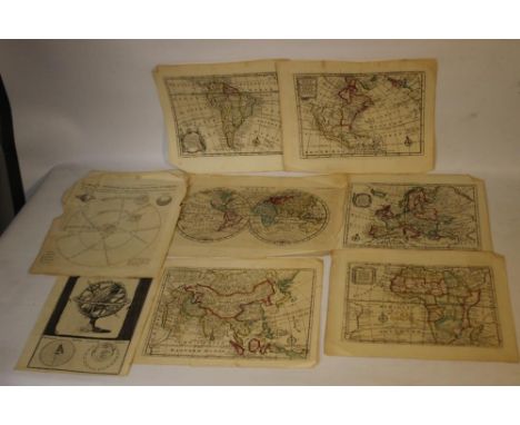
Guillaume Delisle - 'Les Isles Britanniques par Mr. De L'Isle' (Map of Great Britain and Northern Ireland), engraving on laid paper, published in Paris circa 1740, 40cm x 34cm, within a stained wood frame.Buyer’s Premium 24.5% (including VAT @ 0%) of the hammer price. Lots purchased online via the-saleroom.com will attract an additional premium of 5% (including VAT @ 0%) of the hammer price.

Lot 16
Samuel Fox (publisher) - 'An Improv'd Map of the County of Derby', engraving in 16 sections, hand-coloured in outline, folded and backed onto linen, published by Samuel Fox circa 1760, overall 64.5cm x 53cm.This lot is subject to a Buyer’s Premium of 24.5% (including VAT @ 0%) of the hammer price. Purchased online via the-saleroom.com, this lot will attract an additional premium of 5% (including VAT @ 0%) of the hammer price.

Lot 20
F.J. Heger (geographer) - 'A Map of the Post Roads of Germany, and the Ancient States', engraving hand-coloured in outline in 24 sections, folded and backed onto linen, printed for William Faden circa 1789, overall 68cm x 94.5cm, together with two other folding maps.This lot is subject to a Buyer’s Premium of 24.5% (including VAT @ 0%) of the hammer price. Purchased online via the-saleroom.com, this lot will attract an additional premium of 5% (including VAT @ 0%) of the hammer price.

Lot 10
W. & D. Lizars (engravers) - 'A New Travelling Map of Scotland with the Distances in Miles, Constructed & Engraved for Duncan's Itinerary', 19th century engraving in 12 sections, hand-coloured in outline, folded and backed onto linen, published by Lumsden & Sons, overall 50cm x 40.5cm, within a cardboard case with original paper label.This lot is subject to a Buyer’s Premium of 24.5% (including VAT @ 0%) of the hammer price. Purchased online via the-saleroom.com, this lot will attract an additional premium of 5% (including VAT @ 0%) of the hammer price.

Lot 59
After J. Parsons - 'West Indies Antigua, English Harbour', 20th century photolithograph, 64cm x 48cm, within a gilt frame, together with another map of Antigua interest.Buyer’s Premium 24.5% (including VAT @ 0%) of the hammer price. Lots purchased online via the-saleroom.com will attract an additional premium of 5% (including VAT @ 0%) of the hammer price.

Lot 22
Harry Margary (publisher) - 'A Large and Accurate Map of the City of London', facsimile of the 1676 Ogilby and Morgan survey of London, published by Harry Margary in association with Guildhall Library 1976, sheet sizes 44cm x 57cm, within cloth covered boards, together with the introductory notes by Ralph Hyde and a bound explanation booklet.This lot is subject to a Buyer’s Premium of 24.5% (including VAT @ 0%) of the hammer price. Purchased online via the-saleroom.com, this lot will attract an additional premium of 5% (including VAT @ 0%) of the hammer price.
Lot 18
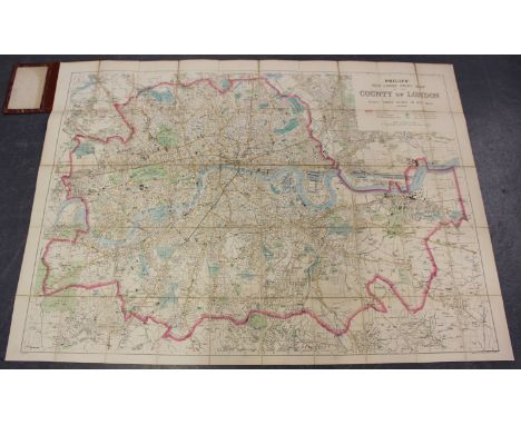
George Philip & Son Ltd (publisher) - 'Philips' New Large Print Map of the County of London', colour lithograph in 50 sections, folded and backed onto linen, overall 103cm x 141.5cm, within cloth covered boards with gilt title.This lot is subject to a Buyer’s Premium of 24.5% (including VAT @ 0%) of the hammer price. Purchased online via the-saleroom.com, this lot will attract an additional premium of 5% (including VAT @ 0%) of the hammer price.

Lot 8
John Albin (publisher) - 'To the Right Honorable Lord Fitz Harris Governor of the Isle of Wight, this Map of the Island is inscribed as a public Testimony of Respect by his very obliged humble Servant John Albin' (Map of the Isle of Wight), engraving in 16 sections, hand-coloured in outline, folded and backed onto linen, published by John Albin circa 1807, overall 40.5cm x 59.5cm, within a cardboard case.This lot is subject to a Buyer’s Premium of 24.5% (including VAT @ 0%) of the hammer price. Purchased online via the-saleroom.com, this lot will attract an additional premium of 5% (including VAT @ 0%) of the hammer price.


Lot 358
ONE box containing a large assortment of book plates, prints, etc. to include: botanical prints, bird prints, maps of England, map of Western Africa, maps of Wales, architectural prints, Arthur Rackham prints from 'A Midsummer Night's Dream', an illustration from Harpers Weekly 'The Same Old Christmas Story Over Again', 'Mother Hubbard's Wonderful Cupboard' first edition prints by Charles Federer, etc. (Charity sale) (B.P. 21% + VAT)
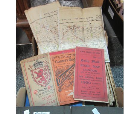
Lot 415
Box of vintage maps and books to include: Daily Mail road map of London 1930 edition, Bacons Country Map of Devonshire, Ordinance Survey of Nairn and Cromarty, Philips tube, bus, and tram way map of London, Mitchelling map of the British Isles, Aberystwyth to Hereford, Bartholomew's pocket plan of Edinburgh and suburbs, etc. Together with two War Office edition maps, one of Oxford and Newbury, the other Banbury, ordinance survey maps dating from 1940s and a collection of The Naval Review dating largely from '70s, with a copy of 'Our Airforce' with coloured plates published by Ward Lock & co. ltd., revised edition 1942.(B. P. 21% + VAT)
Lot 102
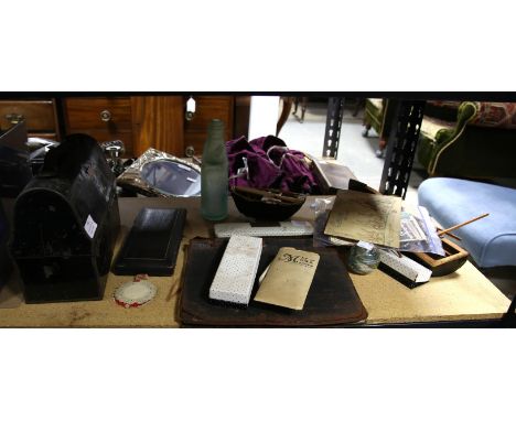
Vintage Union, Canada tinplate lunch box, cod bottle, cased christening set, Alum Bay glass paperweight, millefiori paperweight, rolled gold Parker ballpoint pen, Parker 61 fountain pen and ballpoint pens, model coracle, another model boat, album of matchbox tops, John Player cigarette cards, Cycling 1839-1939, folded map of the Great Western Railway, Japanese an Pakistan banknotes, playing cards and collectors plates mainly Steam Trains and War Ships


Lot 9
Ashmor Fine China for 'History in Porcelain' limited edition figure of Field Marshall The Viscount Montgomery of Alamein, standing on stones with a campaign map on his leg, numbered 26 of 375, with Certificate of Authenticity and box, 29 cm highCondition Report: Good condition, with no damage found. includes certificate, box and sleeve


Lot 156
° ° Demidoff, E. After Wild Sheep in the Altai and Mongolia. With 82 a Coloured Frontispiece and a Map. Roland Ward, London, 1900. Folding map bound at the back. Remainder(?) cloth binding, slightly warped. Together with, Ward, Rowland [Edited by Dollman, Guy and Burlace, J. B.] Rowland Ward’s records of Big Game African and Asian Sections … Tenth edition 1935. Original, rubbed cloth binding. * Inscribed by Malcolm Lyell on the front free endpaper with some note by him in the text. Some papers loosely inserted including three original photographs by [Lord] Arthur Murray tipped onto backing paper with ink descriptions in his hand. (2). Malcolm Lyell (1922-2011) a good shot, a fisherman, a naturalist, a gardener, a hunter, an adventurer, and a raconteur who has been described as having been the doyen of the London gun trade.After being educated at Bryanston and Westminster School, he took a degree in forestry at Bangor University in 1943 and worked as a forester until 1947 when he became the manager of Westley Richards London showrooms.In 1955 when the parent company made the decision to close the London showrooms, Malcolm sought the backing of British and American sportsmen to finance his takeover of the business and established Westley Richards (Agency). Soon after acquiring it he bought Jeffery’s the gun-makers, and later Farlow’s, the fishing tackle specialists.The ultimate salesman, he not only had a comprehensive knowledge but also loved and was proud of what he was offering for sale. Over the next twelve years he developed, expanded, and advanced the business with great panache and the able assistance of his wife Rosamunde (they married in 1949).His success brought its own reward, in 1959 Holland and Holland invited him to merge his company with theirs and he became the managing director of the new enterprise. By the time of his retirement in 1988, he had acquired a plethora of clients many of whom became great friends; they included kings and princes, maharajahs, presidents, and prime ministers. Hollywood stars, white hunters, sportsmen and trophy collectors fell under his spell and with Rosamunde and his two daughters Caroline and Harmony he travelled the world combining business with pleasure.Malcolm was born a collector, as a boy he collected objects to exhibit and opened his own “museum” in his parents’ house in South Kensington (admission to it cost the viewer one penny). Throughout his life his own houses became filled with treasures gathered from across the globe.His passion and the intense enjoyment that he derived from his collection can be seen in the ephemera and the considered personal notes and annotations that he added to most of his books.
![Reed, Stanley. [Ed.] The Indian Year Book. 1914. A Statistical and Historical Annual of the Indian Empire with an Explanation](https://cdn.globalauctionplatform.com/b9568e96-802b-4f45-99cf-ae6900b0990d/f23d2a78-2de1-41f1-9be2-ae6900b2f2b9/468x382.jpg)
Lot 169
Reed, Stanley. [Ed.] The Indian Year Book. 1914. A Statistical and Historical Annual of the Indian Empire with an Explanation of the Principal Topics of the Day. Bombay, 1914. Coloured folding map. Modern Quarter red leather binding, original spine tipped in. Burke, W. S. [Compiler}. The Indian Field Shikar Book. Third edition. Oblong octavo, 1906. Unused “Big Game Register” in pocket inside back cover. Front hinge broken. Original green cloth binding, worn. Together with a tired, incomplete, copy of Duke’s “Kashmir Handbook’, 1903. (3).Malcolm Lyell (1922-2011) a good shot, a fisherman, a naturalist, a gardener, a hunter, an adventurer, and a raconteur who has been described as having been the doyen of the London gun trade.After being educated at Bryanston and Westminster School, he took a degree in forestry at Bangor University in 1943 and worked as a forester until 1947 when he became the manager of Westley Richards London showrooms.In 1955 when the parent company made the decision to close the London showrooms, Malcolm sought the backing of British and American sportsmen to finance his takeover of the business and established Westley Richards (Agency). Soon after acquiring it he bought Jeffery’s the gun-makers, and later Farlow’s, the fishing tackle specialists.The ultimate salesman, he not only had a comprehensive knowledge but also loved and was proud of what he was offering for sale. Over the next twelve years he developed, expanded, and advanced the business with great panache and the able assistance of his wife Rosamunde (they married in 1949).His success brought its own reward, in 1959 Holland and Holland invited him to merge his company with theirs and he became the managing director of the new enterprise. By the time of his retirement in 1988, he had acquired a plethora of clients many of whom became great friends; they included kings and princes, maharajahs, presidents, and prime ministers. Hollywood stars, white hunters, sportsmen and trophy collectors fell under his spell and with Rosamunde and his two daughters Caroline and Harmony he travelled the world combining business with pleasure.Malcolm was born a collector, as a boy he collected objects to exhibit and opened his own “museum” in his parents’ house in South Kensington (admission to it cost the viewer one penny). Throughout his life his own houses became filled with treasures gathered from across the globe.His passion and the intense enjoyment that he derived from his collection can be seen in the ephemera and the considered personal notes and annotations that he added to most of his books.

Lot 248
Pictures - prints, reproduction map of Manchester; frames; etc** We would please ask that all payments are made by 12pm on Thursday 14th April at the latest. Collection for all lots is strictly by appointment at Otterbeck Hall, Chinley, SK23 6AH where all items are located. We request that items are collected on either Wednesday 13th or Thursday 14th April when Bamfords staff will be in attendance. In circumstances where buyers are unable to attend on these days members of the Stoodley family have kindly agreed to be present from Friday 15th to Monday 18th April at 12pm, however all lots must have been paid for by Thursday 14th April. It should be noted that keys will be handed to the new owners of Otterbeck Hall on Tuesday 19th April at which point Bamfords will no longer have access to the property. Bamfords are able, strictly by prior arrangement to bring certain higher value small items to the saleroom for collection at a later date. Please enquire and confirm this availability in relation to any lot that you are hoping Bamfords will be able to move on your behalf. Any such lot will incur a £15 charge**
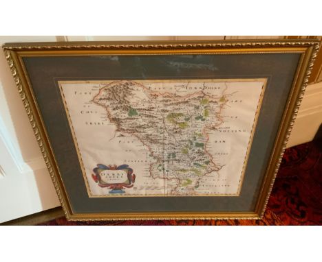
Lot 55
Robert Morden, two page map, Darbyshire (sic), sold by Abel Swale, Awnfham (sic) and John Churchill, London (c.1722) hand coloured engraving, 36cm x 41cm** We would please ask that all payments are made by 12pm on Thursday 14th April at the latest. Collection for all lots is strictly by appointment at Otterbeck Hall, Chinley, SK23 6AH where all items are located. We request that items are collected on either Wednesday 13th or Thursday 14th April when Bamfords staff will be in attendance. In circumstances where buyers are unable to attend on these days members of the Stoodley family have kindly agreed to be present from Friday 15th to Monday 18th April at 12pm, however all lots must have been paid for by Thursday 14th April. It should be noted that keys will be handed to the new owners of Otterbeck Hall on Tuesday 19th April at which point Bamfords will no longer have access to the property. Bamfords are able, strictly by prior arrangement to bring certain higher value small items to the saleroom for collection at a later date. Please enquire and confirm this availability in relation to any lot that you are hoping Bamfords will be able to move on your behalf. Any such lot will incur a £15 charge**


-
109198 item(s)/page