

Sanson/Jaillot, 1692 L`Asie Divisee en ses Principales Regions, et ou se Peut Voir l`Estendue des Empires, Monarchies, Royaumes, et Estats qui Partagent Presentement l`Asie Originally a sculptor, Alexis-Hubert Jaillot began his career in map-making after marrying the daughter of Nicolas Berey. His skill as an engraver and his business acumen brought him to the attention of Nicolas Sanson`s heirs, who hired him to breath new life into their business at about the same time that Blaeu`s important printing works were destroyed by fire. Jaillot re-engraved Sanson`s important maps on an enlarged scale and published them first in Paris and later printed by Pierre Mortier in Amsterdam. This expansive map of Asia is one of the largest and most impressive general maps of the continent. It is based on Sanson`s 1650 map, but Jaillot updated the northeastern coastline from Duval`s map of 1670. The island of Hokkaido is attached to the mainland as part of the "Yupi" peninsula and a huge "Terre de Iesso" (the name normally associated with Hokkaido) appears to the east. Korea is shown as an elongated peninsula. In the East Indies, New Guinea is divided into "Terre de Papous" and "Nouvelle Guinee". Printed on two sheets and joined, as issued. 34.3" W x 21.5" H Issued folding, now pressed with creasing, light toning, and minor soiling. Short tears and chips in blank margins, and two tears at left and right that extend approximately 2" into map image, have all been professionally repaired. Backed in Japanese tissue to reinforce folds and repair several small holes at fold intersections.
We found 109182 price guide item(s) matching your search
There are 109182 lots that match your search criteria. Subscribe now to get instant access to the full price guide service.
Click here to subscribe- List
- Grid
-
109182 item(s)/page

Senex, John 1714 Asia Corrected from the Observation Communicated to the Royal Society at London and the Royal Academy at Paris This large, scarce map generously describes the continent of Asia. It is most remarkable for its detail in the Philippines, Ladrones, and Indonesia. Japan is dwarfed by the huge" Land of Yedso "(Hokkaido) above it, with a note: "It is not known whether the country of Yedso be join`d to Japan or not." The coastline of the "Land of Compagnia" is placed nearby. South of the "Kingdom of Lassa or Boutan", the fictitious "Chamay Lake" is named. The map is dedicated to Sr. George Markham, Baronet in the upper right, and the title cartouche is surrounded with classical figures. Printed on two joined sheets, as issued. 37.5" W x 26" H Some toning, light damp stains and an extraneous crease near center. There are some short tears, repaired with tissue on verso. Paper replaced in the lower corners, with a bit of the neatline at left replaced in facsimile. Even with these flaws, it is an impressive map.
![1740-59 [Lot of 2] Asia [and] An Accurate Map of Asia, Drawn from the Sieur Robert, Geogr. to the French King, with Improveme](http://lot-images.atgmedia.com/SR/36385/2893812/608-2013117142741_468x382.jpg)
1740-59 [Lot of 2] Asia [and] An Accurate Map of Asia, Drawn from the Sieur Robert, Geogr. to the French King, with Improvements "A. “Asia”, by Herman Moll, from Salmon`s “Modern History”, circa 1740 (10.4 x 7.9”). Attractive reduced version of Moll`s map of Asia (1708), which was based on the Delisle prototype. Moll continues the speculation that Iesso Land (Hokkaido) might be attached to the mainland. Published in London in Thomas Salmon`s “Modern History: or the Present State of All Nations”. Condition: Faint toning and light, scattered foxing. (B+) B. “An Accurate Map of Asia, Drawn from the Sieur Robert, Geogr. to the French King, with Improvements”, by George Rollos, from “Geographical Dictionary”, circa 1759 (11.9 x 7.6”). Detailed map depicting all of Europe and Asia showing cities, rivers and topography. The Great Wall of China is shown as Chinese Wall just north of Beijing. Condition: A nice impression with marginal soiling. (A)" #VALUE! See description.

Lapie/Tardieu, 1841 Carte de l`Asie A very attractive, large map of continental Asia extending to and naming Singapore in the south, and to the Bering Straight and the coast of Alaska in the northeast. The map is filled with great detail of political boundaries, place names, topography, and rivers. Surrounded by a decorative keyboard-style border. 21.7" W x 15.8" H Original outline color on bright paper with wide margins, light toning along sheet edges, and a couple of insignificant spots.

Tallis, John 1850 Asia Finely engraved map of Asia that extends from Turkey through China and Russia to show a little of Alaska, and from the Arctic Ocean south to delineate all of the East Indies. Beautifully engraved and rendered vignettes of Petra, Tartars, Russian Peasants, The Walrus, and Sun-Birds of India and the Philippine Isles. The map is surrounded by a decorative border. 12.7" W x 10.2" H Original outline color with minor soiling and faint toning along the sheet`s edges.

Bellin, Jacques Nicolas 1749 Carte de la Tartarie Occidentale pour Servir a l`Histoire Générale des Voyages. Tirée des Auteurs Anglois This map covers western Tartary and focuses on the region of present-day Mongolia. This map reflects information from Kyrkov`s important surveys of this remote region in addition to Jesuit and English sources. It includes detail of the roads and shows sections of the Great Wall. It is dated 1749, when it was first published in the French edition of Prevost`s history of important voyages. 12.2" W x 8.6" H Watermarked paper with a hint of toning along centerfold and faint offsetting.

Buffon, Comte de 1780 Carte des Declinaisons et Inclinaisons de l`Aiguille Aimantee Redigee d`Apres la Table des Observations Magnetiques Faites par les Voyageurs Depuis l`Annee 1775 This chart is sheet number 4 from a series of 8 maps and covers the Pacific Ocean from the Phillipines north to Korea, Japan and a portion of Alaska. The ocean is filled with magnetic readings from various explorers after 1775 with particular emphasis along the coast of Japan, Kamtchatka and the Bering Strait. Published in Buffon`s "Histoire Naturelle Histoire des Mineraux". Please see lot 86 for the map of western North America from this same set that could be joined to form a larger map depicting the entire northern Pacific Ocean. 22.3" W x 22.3" H Issued folding on heavy, watermarked paper with light offsetting. Please note that the blue hue in the image is caused by our scanner and not in the physical map.

Kircher, Athanasius 1697 Imperium Sinicum Quindecupartitum This rare map of China and Korea is based on the work compiled by Jesuit Father Martino Martini. Father Martini`s map was gathered from Chinese sources between 1643 and 1650, and it greatly advanced European knowledge of the region including the correct locations of many cities and topographical features. The trade route between Canton and Peking is noted and the Great Wall and the Gobi Desert are both graphically pictured. This is Kircher`s second copperplate engraving, with more decorative cartouches and the same title. 18.1" W x 13.7" H Watermarked paper with attractive color, light soiling and a few spots of foxing. Professionally remargined at right and left with neatline at left expertly replaced in facsimile.

Robert de Vaugondy, Didier 1770 L`Empire de la Chine Dresse d`Apres les Cartes de l`Atlas Chinois This is a very handsome and finely engraved map with minute political and topographical detail. The large title cartouche is resplendent in the French style with musicians, a dancer, and various accoutrements representative of the country. The map originated in 1751; this is a later edition with the date and privilege removed from the cartouche. 20.9" W x 19.2" H Original outline color on watermarked paper with light toning and scattered foxing. The bottom edge of the sheet is a bit crumpled, far from image.

Kitchin, Thomas 1782 A New Map of China Drawn from Surveys Made by Order of the Emperor This later Kitchin map of China and its surroundings stretches from Tibet to the Sea of Japan, here called the "Sea of Korea". China is dense with detail, with mountains, provinces, rivers, and many cities noted. "Tay-wan or Formosa I.", "Nan-King", Canton, and the Gulf of Tonkin appear. There is a compass rose topped with a fleur-de-lis, two distance scales, a decorative title cartouche featuring figures in local dress near a massive vase, and a key at bottom left that translates regional geographic terms into English. 14.9" W x 13.3" H Issued folding with wide margins, faint offsetting, and light toning confined to the sheet`s edges.

Duval, Pierre 1682 Isles du Iapon This little map is important in the cartographic history of Japan because it presents a new form in the evolution of the European mapping of Japan. Duval altered the Blancus/Moreira type by changing Lake Biwa into a wide gulf, while Kyushu appears as a very rugged narrow island and Honshu takes on an exaggerated mushroom shape. This cartography was copied by several other cartographers, particularly in pocket atlases. This is a later state of the map with Korea acknowledged as being a peninsula. Pierre Duval was Nicolas Sanson`s nephew and pupil. He published a wide range of atlases and individual maps including a fine miniature world geography with many of the maps based on Sanson. 5" W x 4" H Watermarked paper with a hint of toning along centerfold.

Reland, Adrien 1715 Le Japon Divise en Soissante et Six Provinces, Cette Carte est Tiree des Cartes des Japonois par Mounsieur Reland [in book] Recueil de Voyages au Nord, Contenant divers Memoires tres utiles au Commerce & a la Navigation… "This first edition map of Japan shows the 66 provinces with both Roman and Sino-Japanese names. It is the first Western-produced map using Japanese cartography and ignoring the prior European use of fictitious names. The inset map of Nagasaki “Vue de la Ville de Nangasacki...” is at lower center and is surrounded by 21 Armories of the Emperor and his shoguns. The map is bound into the original and complete “Recueil de Voyages au Nord, Contenant divers Memoires tres utiles au Commerce & a la Navigation. Tome Troisieme..” by Jean Frederic Bernard (4 x 6.8”). This edition also includes a second map, “L`ile de Terre Neuve et le Golfe de Saint Laurent, Selon les Meilleurs Memoires” (12.5 x 8”) which shows the Gulf of Saint Lawrence bounded by Nova Scotia and Newfoundland and also depicts the Grand Banks. In original full leather with raised and gilt spine, red fore-edges, title page in red & black with engraved “A Limmorta-Lite”, 340 pp., and two folding maps." 17.5" W x 11.8" H The maps are in near fine condition with only a hint of toning along the edges of the sheet and minor misfolding of the Canadian map. Contents are fine, and the original binding is very good with light shelf wear.

Chatelain, Henry Abraham 1719 L`Empire du Japon, Tire des Cartes des Japonnois This bold map of Japan is based on Adrian Reland`s map of 1715. Reland`s map was based on a Japanese model that had been produced as a travel map. As such, the geographical shape of the islands was made to fit into a predetermined format. This distorted shape resulted in a truncated Honshu, thus actually setting the European cartography of Japan backwards for a short period of time. On the other hand, the superb depiction of Kyushu is not surpassed until the 19th century. Reland`s map is also important for its use of Sino-Japanese characters (in addition to Dutch) for all sixty-six provinces. Chatelain`s version includes several errors in the Dutch names, which were likely not noticed by his French clientele. An inset map of Nagasaki shows the Dejima, an artificial island in Nagasaki harbor that housed the Dutch trading station of the VOC. Chatelain`s elaborate cartouche notes the Japanese basis for the map, but does not mention Reland. 17.3" W x 14.3" H A clean, bright example with a dark impression on watermarked paper with wide margins.

Bellin, Jacques Nicolas 1752 Carte de l`Empire du Japon This is a reduced Dutch version of Bellin`s influential map made for Jesuit Father Pierre-Francois-Xavier de Charlevoix`s "Histoire du Japon". Japan is presented on the Kaempfer/Scheuchzer model with several corrections to the coastlines, and individual provinces are delineated via engraved line. The "Mer de Coree" is shown to the west. The decorative rococo-style title cartouche includes two distance scales. Dutch title below the map image. 12.3" W x 8.5" H Issued folding with one very faint damp stain.

Linschoten/Langren, 1595 Exacta & Accurata Delineatio cum Orarum Maritimarum tum Etiam Locorum Terrestrium quae in Regionibus China, Cauchinchina, Camboja sive Champa, Syao, Malacca, Arracan & Pegu... This influential map was the first published map of the Far East to be derived from Portuguese sources. Thus it is credited with breaking the Portuguese monopoly on the East Indian trade and was among the most important sources of information on Southeast Asia during the sixteenth century. The map is oriented with north to the left by two gorgeous compass roses. While based primarily on Portuguese portolan charts, Linschoten also drew on the cartographic work of Plancius. Southeast Asia and Japan are based on the cartography of Fernão Vaz Dourado, and China on the map of Barbuda. The Philippines is drawn from de Lasso with the curious orientation of Palawan. In other regions, Linschoten draws upon the reports of Marco Polo, most notably for the location of the mythical land of "Beach provincia aurifera"in the region where Australia would eventually be discovered. On the mainland, the course of the Mekong is placed too far west, significantly distorting the region and four large lakes in the interior are based on Chinese legend. "Corea" is shown as a large circular island. The map was beautifully engraved by Langren and is richly adorned with sea monsters and sailing vessels, along with a number of animals in the interior of China. Printed on two sheets, as issued. 20.6" W x 15.3" H A fine impression on watermarked paper with attractive old color that has been lightly refreshed. Issued folding, now pressed with professional repairs to a few tiny holes at fold intersections. There is some printer`s ink residue, overall light toning and soiling, and a tear in border at top left that has also been professionally repaired. Narrow margins.

Hondius/Purchas, 1625 India Orientalis Fine example of this reduced version of Jodocus Hondius` important map of mainland Southeast Asia. It covers the region from the Indian sub-continent through Burma and Thailand, to the Philippines and extends to the tip of the Malaysian peninsula with parts of Borneo and Sumatra. It depicts the classical view of the river systems originating in a mythical "Chiamai Lacus". India is much too narrow, Ceylon is overly large, and two large lakes are depicted in China. On a full sheet of English text (7.7 x 12.3"). 7.2" W x 5.6" H A nice impression with light show-through of text on verso and some toning along sheet edges. Trimmed close to neatline at left, as issued.

Duval, Pierre 1682 Presqu`Isle de Linde de la le Gange This miniature map of Southeast Asia extends from Burma and China in the north to a portion of Sumatra in the south. The map depicts major towns, key topographical features, and dozens of tiny islands. Pierre Duval was Nicolas Sanson`s nephew and pupil. He published a wide range of atlases and individual maps including a fine miniature world geography with many of the maps based on Sanson. 3.9" W x 4.9" H A nice impression on watermarked paper with attractive old color that has been partially refreshed and light toning along centerfold and sheet edges.

Brion de la Tour/Desnos, 1766 Chine et Indes avec les Isles; d`Apres les Descriptions les Plus Exactes Lovely map covering the region from India, through China and the Philippines and south to include all of Indonesia. It is decorated with a delicately engraved title cartouche and surrounded by an ornate border. 12.4" W x 11.1" H This example has ample margins as well as light scattered foxing, a stain on part of the border at left, slight toning along the centerfold, and a 1/2" centerfold separation at bottom that just touches the border.

Migeon, J. 1874 Indo-Chine et Archipel d`Asie This map of Southeast Asia gives excellent detail of towns, harbors, rivers and topography. The map includes a lovely vignette of Norodom Palace in Saigon (Ho Chi Minh City), which was built by the French in 1873 and housed the Governors-General of French Indochina until the region was captured by the Japanese in World War I. Sadly, the palace was destroyed during the Vietnam War, and a new palace (named Independence Palace) was built in its place shortly thereafter. Engraved by L. Smith with lettering by A. Bixet, and published by Charles Lacoste. 16.7" W x 12.9" H Original color with a hint of toning.

Hondius/Bertius, 1618 Arachan & Pegu North is shown to the left of this miniature map of the Burmese kingdoms of Arakan and Pegu. The map extends to also cover a portion of Thailand with the city of "Siam" shown on a large island near the mouth of the "Menan fluvius" (Chao Phraya River). French text on verso. 5.3" W x 3.7" H A nice impression with attractive color and very light toning.

Duval, Pierre 1682 Isles Philippines dites Autrement de Manilhe This miniature map of the Philippines includes parts of China and Borneo, and depicts major towns and key topographical features. The fictitious island of San Juan ("I. S. Iuan") appears in one of its largest configurations. Pierre Duval was Nicolas Sanson`s nephew and pupil. He published a wide range of atlases and individual maps including a fine miniature world geography with many of the maps based on Sanson. 5.1" W x 4.1" H Watermarked paper with a hint of toning along centerfold.

Duval, Pierre 1682 Isles Molucques Charming miniature map of the famous "Spice Islands" depicting even some very tiny islands. Pierre Duval was Nicolas Sanson`s nephew and pupil. He published a wide range of atlases and individual maps including a fine miniature world geography with many of the maps based on Sanson. 4.9" W x 3.9" H A nice impression on watermarked paper with attractive old color that has been partially refreshed and light toning along centerfold and sheet edges.

Hondius/Bertius, 1618 Iava Maior This precisely engraved map shows the northern coastline with numerous place names, but the southern coastline is entirely conjectural. The map is handsomely adorned with two strapwork cartouches and a ship. French text on verso. 5.2" W x 3.8" H A nice impression with light show-through of text on verso and one small spot in distance scale cartouche.
![Waldseemuller/Fries, 1541 [Title on Verso] Asiae Tabula Decima Continet Indiam intra Gangem This woodblock map illustrates th](http://lot-images.atgmedia.com/SR/36385/2893812/639-2013117142844_468x382.jpg)
Waldseemuller/Fries, 1541 [Title on Verso] Asiae Tabula Decima Continet Indiam intra Gangem This woodblock map illustrates the Ptolemaic concept of the region between the deltas of the Indus and Ganges Rivers. The map is reduced from Martin Waldseemuller`s map and presents the region with large mountain ranges, bold rivers and numerous place names. Following Ptolemy`s outline, southern India is severely truncated and the northern tip of Taprobana appears incorrectly to the west of the subcontinent. Latin title and text on verso. 18.8" W x 11.8" H A clean, bright example with a hint of toning along centerfold in blank margins, and two tiny holes in blank margins.
![1740-63 [Lot of 4] India Proper, or the Empire of the Great Mogul [and] A New Map of the Seat of War on the Coast of Malabar](http://lot-images.atgmedia.com/SR/36385/2893812/640-2013117142847_468x382.jpg)
1740-63 [Lot of 4] India Proper, or the Empire of the Great Mogul [and] A New Map of the Seat of War on the Coast of Malabar & Coromandel, in the Empire of the Great Mogol... [and] Bombay on the Malabar Coast... [and] Fort St. George on the Coromandel Coast... "A. “India Proper, or the Empire of the Great Mogul”, by Herman Moll, from Salmon`s “Modern History”, circa 1740 (7.1 x 10.2”). This interesting map of India extends from the Maldives and Sri Lanka in the south to Tibet in the north and provides many place names of regions, towns, mountains, rivers, and even a “road beset with trees” is labeled. The British interests in this region correspond to the East India Company`s growing influence in India. Published in London in Thomas Salmon`s “Modern History: or the Present State of All Nations.” Condition: A dark impression with light toning. (B+) B. “A New Map of the Seat of War on the Coast of Malabar & Coromandel, in the Empire of the Great Mogol. Drawn from the Best Authorities”, by Thomas Kithcin, from “Annual Register”, dated 1763 (8.9 x 9.6”). This copper engraved map locates major towns, rivers and mountain ranges. It extends from the Indus River to Tibet, the Kingdom of Asam in the east, and includes Sri Lanka. Finely engraved with a decorative rococo-style title cartouche. Condition: Issued folding with a binding trim at bottom and a narrow margin at left. (B+) C. “Bombay on the Malabar Coast, Belonging to the East India Company of England”, from “Royal Magazine”, circa 1760 (8.6 x 6.2”). This small view shows the city of Bombay with several sailing ships and boats in the bay. Condition: Issued folding with light offsetting from an opposing text page and a few faint spots of foxing. (B+) D. “Fort St. George on the Coromandel Coast, Belonging to the East India Company of England”, by Benjamin Cole, from “Royal Magazine”, circa 1760 (8.4 x 6.2”). View of the first British fort in India built in 1644. Condition: Issued folding with light offsetting from an opposing text page, a bit of toning, and a few faint spots of foxing. (B)" #VALUE! See description.

Aspin/Lavoisne, 1820 Geographical, Historical, and Statistical Map of India This is the first American edition of this informative map of India, updated from the London edition of 1817 and published by M. Carey & Son. In addition to showing political divisions, towns, rivers, mountains, and other topographical features, the map notes the dates and locations of a plethora of battles and naval engagements as well as marking British possessions and dependencies. The map is surrounded by English text describing the nation`s geographical features and history, with a list at bottom detailing the specifics of some of the battles shown in the map above. An alternate title, "Hindoostan; or, India: Drawn from the Most Recent Authorities, for the Illustration of Lavoisne`s Genealogical, Historical, Chronological, and Geographical Atlas", appears in a cartouche within the map. Originally engraved by Kneass and printed by T.H. Palmer. With surrounding text, the sheet measures 20.7 x 16.6." 12.8" W x 13.2" H Original color with light toning along the centerfold and minor offsetting. There is a centerfold separation at top that just enters the neatline of map image and another at bottom that enters about 1" into the text, both of which have been closed on verso with archival tape. Inches away, a tear measuring approximately 2" also enters the text and has also been closed on verso.

Sanson, Nicolas Fils 1683 L`Empire du Grand Mogol This small map covers Northern India and present-day Nepal and Bangladesh and shows the political divisions, topography, cities and major towns. At right is the mythical "Lac de Chiamay". It is decorated with a nice title cartouche. 9.6" W x 7.5" H A nice impression with light toning and a few small spots. The right margin has been extended with old paper to accommodate framing.

Hondius/Bertius, 1618 Narsinga This charming miniature map of southern India and Ceylon is oriented with north to the left. Narsinga, referred to as the Kingdom of Bisnaga by the Portuguese, was the Hindu Vijayanagara Empire that controlled southern India. French text on verso. 5.3" W x 3.9" H Attractive color with light, overall toning.
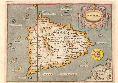
Porcacchi, Tomaso 1576 Taprobana Charming map of the island nation of Sri Lanka with north oriented to the right of the map. Only a bit of the Indian mainland is shown and it is incorrectly depicted to the east of the island. Strapwork title cartouche, an unusual compass rose and a stipple engraved sea combine to make this a very attractive map. Engraved by Girolamo Porro and printed on a full sheet (7 x 10.3") of Italian text. 5.5" W x 4" H Marginal soiling and manuscript ink above the map.

Magini, Giovanni Antonio 1620 Tabula Asiae XII Ptolemy`s twelfth map of Asia depicting "Taprobana" (Sri Lanka) based on Gastaldi`s 1548 map. There is a picture of an elephant and descriptive text next to the map, which identifies the island of Taprobana with Sumatra - a common sixteenth century confusion concerning this island. On a full sheet (11.5 x 8") with Italian text below. 6.8" W x 5" H Watermarked paper with one small rust spot towards top of island and marginal soiling.

Kircher, Athanasius 1665 Tabula Geographica Hydrophylacium Asiae Majoris Exhibens, quo Omnia Flumina Sive Proxime Sive Remote per Occultos Maeandros Originem Suam Sortiuntur The Jesuit scholar Athanasius Kircher was one of the first compilers of semi-scientific knowledge about the physical features of the world. This very unusual map depicts all of southern Asia from the Arabian peninsula to the Philippines including the East Indies to the Celebes. It extends north to show part of the Caspian Sea. The map has limited political detail with only regions and countries named, plus the principal rivers, lakes and mountains. A huge subterranean lake in the area of Nepal and Tibet is the principle source for most of the rivers in Asia. Decorative title cartouche features angels or putti, and Neptune. Kircher`s "Mundus Subterraneus" (The Underground World) was the first serious effort to describe the physical makeup of the earth, proposing theories (sometimes fantastic) in the areas of physics, geography, geology, and chemistry. 16.1" W x 13.5" H A fine impression on watermarked paper with a professionally repaired worm track confined to top blank margin. What appears in the image to be toning along the centerfold is just show-through of the back strap on verso.

Ptolemy/Mercator, 1730 Tab. IX. Asiae, Continens Ariam, Paropanisum, Drangianam, Arachosiam, et Gedrosiam... This fine copper engraved map covers the region to the west of the Indus River in what is present-day Pakistan. Mercator originally published this map in his 1578 edition of Ptolemy`s great Geography. Although he is most renowned today for the projection he popularized and for first using the term "Atlas" for a collection of maps, he devoted much of his life to his Ptolemaic maps. The maps were beautifully engraved as nearly as possible to their original form and embellished with fine cartouches. This is the third state with a re-engraved title cartouche and the addition of a grid, published by R. and J. Westenios and Guil. Smith. 15.5" W x 13.6" H Nice impression and color on watermarked paper with a couple of tiny, insignificant spots in image and light toning along sheet edges, far from image.

Child, G. 1745 A Chart of the Coast of Persia, Guzarat, & Malabar Drawn from the French Chart of ye Eastern Ocean An attractive copper engraved chart centered on the Arabian Sea that shows some of the Persian Gulf and the Gulf of Oman, extending past Persia to include half of India. The map locates the Maldives and many offshore islands and details capes, shoals, bays, and major harbors. The map is decorated with a compass rose with fleur-de-lys at center and a rococo-style title cartouche featuring a fountain, sea-horse, water nymph, and two wind heads. Engraved by G. Child. 7.8" W x 9.7" H Light offsetting.

Hondius/Bertius, 1616 Africa A reduced version of Hondius` superb map of the continent. It is based on the Mercator model with revisions to the coastlines, particularly that of Madagascar. Hondius improved the Cape area by inserting "C. Falco" and discarding Cayneca. In western Africa, the Niger River flows in a fairly straight line to the Atlantic, and two large lakes south of the equator are shown as the source of the Nile River. The map is crisply engraved and decorated with strapwork title and distance scale cartouches. Latin title page on verso. 5.3" W x 3.8" H A nice impression with attractive color and light toning.
![Hondius/Purchas, 1625 [Lot of 3] Barbaria [and] Congi Regnu [and] Guinea "At the beginning of the 17th century, Purchas,](http://lot-images.atgmedia.com/SR/36385/2893812/655-2013117142919_468x382.jpg)
Hondius/Purchas, 1625 [Lot of 3] Barbaria [and] Congi Regnu [and] Guinea "At the beginning of the 17th century, Purchas, an English cleric, set out to publish a compendium of voyages to foreign countries. To illustrate his work, Purchase obtained the rights to use Jodocus Hondius` copperplates from “Atlas Minor”. Over 60 maps were included in “Purchas His Pilgrimes”, most of which were from Hondius` plates, with English titles inserted above them. This lot features three regional maps of Africa from this publication. Each is on a full sheet of English text (8.0 x 12.5”) with text on verso. A. “Barbaria”. Includes two smaller maps below showing Carthage and the Nile Delta. Condition: There are a few light spots and a small horizontal extraneous crease. (B) B. “Congi Regnu”. Condition: Light damp stains in the text below the map, away from the image. (A) C. “Guinea”. Includes an inset of St. Thomas. Condition: Light soiling with an extraneous crease along the left side of the image. Narrow left margin, as issued. (B+)" 7" W x 5.7" H See description.

Speed, John 1626 Africae, Described, the Manners of their Habits, and Buildinge… This decorative map is the first map of Africa prepared by an English cartographer. It is based closely on the maps of Jodocus Hondius and Willem Blaeu. It presents a typical, early seventeenth century view of the continent with the interior filled with fictitious mountains, rivers and lakes. The origin of the Nile conforms to the Ptolemaic tradition of the large twin lakes in the southern part of the continent. The kingdom of "Monomotapa" occupies a large region in southern Africa. There are numerous interesting notations, including several concerning where gold can be found. The English text on verso provides a fascinating view of the European concept concerning the wildlife, customs and manners of the African people. There is a description of "Anthropophagi", cannibals, who kill their own babies to avoid the trouble of raising them; but, in order to preserve their race, steal children from their neighbors. The beautiful carte-a-figures border features natives in their tribal costumes. At top is a panel of panoramas and plans illustrating Tanger, Ceuta, Alger, Tunis, Alexandria, Cairo (Alca), Mozambique and the Canaries. Finely engraved by Abraham Goos, with his signature at lower left. This is the first state, published and sold by George Humble between 1631-32. 20.1" W x 15.4" H A fine, early impression with attractive color, minor show-through of text on verso, and a few short tears confined to blank margins that have been professionally repaired. There is light toning along sheet edges.

Mercator/Cloppenburgh, 1673 Africae Nova Tabula This fine chart details the entire continent of Africa with Madagascar and the Arabian Peninsula. It was published in the Cloppenburgh atlas and is taken from Hondius` folio map of the same title (Norwich Africa #34). Includes the hypothetical interior detail, which is typical of maps from this period. The Nile originates from two large lakes well south of the Equator. Decorated in the sea with numerous sailing ships and sea monsters. Strapwork style title cartouche. Engraved by Pieter van den Keere. 9.7" W x 7.3" H A nice impression on a moderately toned sheet with light offsetting.

Visscher, Nicolas 1677 Africae Accurata Tabula This beautiful map of the African continent is typical of the late seventeenth century, including updated information taken from Blaeu`s wall map of the continent. The "Cuama" and" Spirito Santo" Rivers are shown with a common source in the "Sacaf Lacus" in South Africa. The Nile arises from the two lakes of "Zaire" and "Zafflan", located below the Equator, as according to Ptolemy The interior is decorated with elephants, ostriches, monkeys, lions and rhinoceros, and eleven small ships sail in the sea. The title cartouche is flanked by natives and angels, and in the lower left is a dedication cartouche with the coat of arms of Gerardo Schaep surrounded by Neptune and his entourage. This is the second state of the map with the notation of privilege in the bottom. 21.4" W x 17.2" H Attractive original color that has been partially refreshed with light soiling.

Jefferys, Thomas 1749 Africa Interesting small map of the continent. The source of the Nile is in the correct vicinity, here called "Nilehead" and shown to be in "Tzana Lake". Several regions are named, including "Caffraria", "Hottentots", and the Sahara, here labeled "Zaara or the Desart". The twin lakes of Zaire and Zaflan are shown north of the Mountains of the Moon. The map stretches to include the eastern tip of South America, as well as parts of Europe and Asia, but these areas are largely left blank. A decorative title cartouche depicts a coastal scene complete with a crocodile. 9.6" W x 7.2" H Issued folding.

Elwe, Jan Barend 1792 L`Afrique Divisee en ses Empires, Royaumes, et Etats… This handsome, large map of Africa was copied from Jaillot`s popular and influential map from more than a century earlier (1674). The cartography is typical for the seventeenth century with the Nile originating in two large lakes below the equator. The River Zaire (Congo) also arises from Lake Zaire. The Kingdom of Monomotapa is shown with its capital on the "Rio de Spirito Santa", and "Vigiti Magna" is also depicted. The map is richly embellished, also in the seventeenth century style, with two elaborate cartouches featuring allegorical figures and wild animals. 23" W x 18" H Attractive old color on paper with two elephant watermarks and light soiling.

Lapie/Tardieu, 1841 Carte d`Afrique Large and very finely engraved map of the continent shows political boundaries delineated by engraved line and beautiful hand coloring. The interior still shows a large, but increasingly smaller, blank area. The mapped areas show rich information including villages, trails, deserts, oases, topography and many helpful notations. This decorative map is embellished by fancy titling with flourishes and a keyboard style border. 21.8" W x 15.7" H Original outline color with wide margins, a few small spots, and light toning along sheet edges.

Ortelius, Abraham 1571 Barbariae et Biledulgerid, Nova Descriptio Handsome map of the famed Barbary coast based on Gastaldi`s Africa. The map extends from Morocco to Libya and the western Mediterranean showing the proximity of the Balearic Islands, Corsica, Sardinia, southern Italy and Sicily. Richly engraved with place names, mountains, and numerous spurious lakes in the Sahara Desert. The title is contained in a strapwork panel across the top. Two fantastic sea monsters and a sailing ship ornament the map. Latin text on verso with page number 53. Only 275 copies of this 1571 Latin edition were printed. 20" W x 13" H Centerfold separation has been repaired on verso with archival material. Narrow left margin as issued with some minor soiling.

Ptolemy/Ruscelli, 1599 Tabula Africae III Finely engraved Ptolemaic map of eastern Libya and Egypt with numerous ancient place names. The interior is filled with mountains as well as some spurious lakes and rivers. Indigenous animals have been added to a blank region at lower left. Italian text on verso. 9.7" W x 7.3" H Ample margins with slight show-through of text on verso and light printer`s ink residue.

Hondius/Bertius, 1618 Barbaria This interesting small map of Northern Africa extends to include the Iberian Peninsula and the western Mediterranean. The map is adorned with a finely rendered ship sailing into the Strait of Gibraltar and a decorative title cartouche. Latin text on verso. 5.3" W x 3.8" H A fine impression with toning and a few minute worm holes in top blank margin.

Homann, Johann Christoph 1728 Statuum Marocca Norum, Regnorum Nempe Fessani, Maroccani, Tafiletani et Segelomessani... Large and very graphic map showing the domains of desert tribes by means of little tent cities. It extends to include the Canary Islands and an inset of Madeira. In the upper left is a large pictorial cartouche with merchants, soldiers, wild animals, a view of Tangier, and a sea battle. Below the map are two panoramic city views of "Morocco" (Marrakech) and "Mequinetz" (Meknes). 21.8" W x 19" H On watermarked paper with a centerfold separation entering 1 1/2" into the image and a nearby 1/2" edge tear at bottom that have been closed on verso with archival material. There are also a few small abrasions and light scattered foxing primarily in the blank margins.

Stanford, Edward 1883 A Map of the Nile, from the Equatorial Lakes to the Mediterranean, Embracing the Egyptian Sudan (Kordofan, Darfur, &c.) and Abyssinia This folding map spans from the "Mouths of the Nile" in the Mediterranean down to Lake Victoria. Many African nations, cities, rivers, lakes, and mountains are identified. Stanford took control of his partner Trelawney Saunders` map dealership at the age of 25 and was prolific and popular in a time when British colonial expansion increased the public`s demand for maps of the world. 21.3" W x 25.9" H Issued folding and backed in linen with some light foxing and faint soiling.

Ptolemy/Mercator, 1578 Africae .I. Tab Lovely Ptolemaic map of the northwestern part of Africa, filled with ancient names, including the Straits of Gibraltar, here called the "Herculeu fretum". Although he is most renowned today for his map projection and the popularization of the term Atlas for a collection of maps, Gerard Mercator devoted much of his life to his Ptolemaic maps. The maps were beautifully engraved as nearly as possible to their original form from Ptolemy`s textual descriptions and embellished with fine cartouches and scenes. This map is decorated with a lovely strapwork cartouche festooned with garlands of fruit and the stipple engraved sea includes a scene of a sea monster and sailing ship. Latin text on verso. 18.2" W x 12.7" H A dark impression on watermarked paper with good margins, very light show through of text on verso, and professional repairs to a few chips and holes in bottom blank margin, not affecting map.

Jansson, Jan 1665 Aegypti Recentior Descriptio: Aegyptis & Turcis Elchibith; Arabibus Mesre & Misri, Hebraeis Mitsraim This is a wonderful map of Egypt oriented with north to the right. Cairo is here named "Alcairo", and the area surrounding the city is replete with detail, including a mention of the Pyramids. The detail becomes increasingly scarce as you go away from the city; instead there are charming camels, goats, horses, sheep and Nile crocodiles, one of whom is shown carrying her baby in her mouth. The cartouche is surrounded by people of the region with the Pyramids in the background. 19.7" W x 15.9" H A nice impression with wide margins. There are professional repairs to several centerfold separations, a hole at bottom that enters 1" into image at centerfold with image expertly replaced in facsimile, and several large chips confined to blank margins.

Homann, Johann Baptist 1720 Aegyptus Hodierna... This magnificent, graphic map of Egypt is focused on the Nile River Valley from the Mediterranean to below the First Cataract at the confluence of the White and Blue Nile. Nearly a third of the map is engraved with fascinating scenes of the cataracts, the Sphinx, pyramids, various antiquities, scenes of embalming, and ancient furnaces. 18.6" W x 22.7" H Watermarked paper with attractive old color that has been partially refreshed and marginal soiling.

Mercator/Cloppenburgh, 1632 Abissinorum, sive Pretiosi Ioannis Imperium The legendary kingdom of the Christian Prester John is the central focus of this small and densely engraved map of central Africa. It is a reduced edition of the folio Mercator map and is cartographically similar to Ortelius` map and is based on the travels of the Portuguese explorer, Francisco Alveres, who searched for the mythical kingdom in the year 1520. The kingdom itself is shown atop the "Amara Monti" in the region where Alveres encountered the Coptic Christian ruler David II. The Nile is shown with its source in the Ptolemaic twin lakes of "Zaire" and the unnamed" Zaflan", at the foot of the Mountains of the Moon ("Zet Montes"). The map includes fancy script lettering, a large strapwork title cartouche and a bold moiré patterned sea. French text on verso and page number 607 on recto. 9.9" W x 7.4" H Very light scattered foxing with a few tiny chips and tears in blank margins that have been archivally repaired.

Linschoten/Langren, 1596 Typus Orarum Maritimarum Guineae, Manicongo, & Angolae ultra Promontorium Bonae Spei … This is one of the most richly ornamented maps in early cartography, superbly engraved in the Flemish style by Arnold Florent van Langren. The cartouche contains a description of the region in both Latin and Dutch that credits the source as "the very best Indian maps" - referring to maps that Linschoten had access to when he was Secretary to the Portuguese Archbishop of Goa in India. The map covers the southwestern coast of Africa from the Gulf of Guinea to just beyond the Cape of Good Hope with excellent detail along the coastline. The fictitious cities of "Vigiti Magna" and "Monomotapa" are located and most place names and geographical features have Portuguese nomenclature. The mainland is embellished with snakes, an elephant, a rhinoceros, a lion and a pair of sirens in Lake Zaire. The balance of the sheet is filled with fabulous cartouches, the Portuguese arms, elaborate compass roses, sailing ships and a sea monster. The large bottom cartouche encloses views of Ascension and St. Helena Islands; important refueling ports in the route around Africa. 21" W x 15.5" H Issued folding on watermarked paper with light soiling and professional repairs to several fold separations, a binding trim and resulting 2.5" binding tear at left, and a 6.5" tear at left. There is also a professionally repaired area of loss along fold at top left with a minor amount of engraving in facsimile.

Kircher, Athanasius 1665 Hydrophylacium Africae Precipuum, in Montibus Lunae Situm, Lacus et Flumina Praecipua Funden Ubi et Nova Inventio Originis Nili Describitur Fascinating map of the southern part of Africa showing the "fountains of the Nile" located in an underground cavern beneath the Mountains of the Moon. Kircher`s map illustrates a report by Peter Paez, a contemporary Jesuit colleague, that purportedly observed the `fountains` in 1618. Athanasius Kircher was a Jesuit scholar whose theories included the notion that the world`s oceans were all interconnected and there was a vast network of underground springs and reservoirs. Published in Kircher`s famous "Subterranean World". 16.3" W x 13.5" H Attractive color on watermarked paper with some printer`s ink residue and a professionally repaired centerfold separation that just enters image at top.
![Bellin, Jacques Nicolas 1739-60 [Lot of 3] Plan du Fort et de la Ville du Cap de Bonne Esperance [and] Coste Occidentale d`Af](http://lot-images.atgmedia.com/SR/36385/2893812/680-2013117143011_468x382.jpg)
Bellin, Jacques Nicolas 1739-60 [Lot of 3] Plan du Fort et de la Ville du Cap de Bonne Esperance [and] Coste Occidentale d`Afrique, Depuis le XIe. Degre de Latitude Meridionale... [and] Carte de la Baye de Sainte Helene Dressee sur les Remarques des Navigateurs "A. “Plan du Fort et de la Ville du Cap de Bonne Esperance”, circa 1760 (10.4 x 8.1”). Detailed plan of the Dutch fort and settlement at the Cape of Good Hope showing the town and fort with a key at bottom listing fourteen important locations. B. “Coste Occidentale d`Afrique, Depuis le XIe. Degre de Latitude Meridionale...”, dated 1739 (10.3 x 9.7”). Covers the southwestern coast of Africa extending from Benguela to the Cape of Good Hope, presenting coastal detail only. The map extends west to include St. Helena island. Adorned with a decorative title cartouche and a compass rose. Condition: Issued folding with a binding trim at bottom left that has been professionally replaced with old paper. C. “Carte de la Baye de Sainte Helene Dressee sur les Remarques des Navigateurs”, circa 1760 (6.4 x 8.3”). This chart of St. Helena Bay, just north of Cape Town, shows soundings, safe anchorages, shoals, and the topography of the coastline." #VALUE! Bright clean examples on watermarked paper. See description for additional details.

Bellin, Jacques Nicolas 1754 Le Pays des Hottentots aux Environs du Cap de Bonne Esperance A beautifully engraved copper-plate map of the Cape of Good Hope from Saint Helena Bay to Mossel Bay. Dutch settlements are mostly confined along the coast and southern regions. The inland regions are depicted as deserts, savannas, forests and mountain ranges with tribal names indicated and a few Boer colonies. 13.6" W x 9.6" H Issued folding, now pressed with minor offsetting and a few extraneous creases. A binding trim at top right has been replaced with old paper, and the map has also been remargined at top with old paper.

Philip, George 1880 Philips` New Map of Southern Africa, Including the Cape Colony, Natal, British Kaffraria, & the Diamond Fields This detailed map, published for the British tourist, depicts Southern Africa below the Tropic of Capricorn. It is filled with detail of the settlements in the region including the Transvaal Republic, the Orange River Free State and native tribes. The land to the north is noted as simply "bushmen". The map is dissected and backed with linen. Folds into red embossed cloth boards with gilt title on front cover. Published by George Philip & Son. 20.2" W x 24.2" H Light soiling and scattered foxing. Covers show minor wear.
![Robert de Vaugondy, Didier 1772 [Lot of 2] Carte des Parties Nord et Est de l`Asie qui Comprend les Cotes de la Russie Asiati](http://lot-images.atgmedia.com/SR/36385/2893812/685-2013117143020_468x382.jpg)
Robert de Vaugondy, Didier 1772 [Lot of 2] Carte des Parties Nord et Est de l`Asie qui Comprend les Cotes de la Russie Asiatique le Kamschatka, le Jesso, et les Isles du Japon... [and] Carte des Nouvelles Decouvertes [on sheet with] Extrait d`une Carte Japonoise de l`Univers "A. “Carte des Parties Nord et Est de l`Asie qui Comprend les Cotes de la Russie Asiatique le Kamschatka, le Jesso, et les Isles du Japon...”, hand color (14.8 x 11.8”). This unusual map details the northern coastline of Russia (including Scandinavia), the eastern coast of Asia to below Nanking, and a bit of the coast of America called “Anian”. Inset into the map are four small maps of the western part of North America: I - Features the entire western coast with Japan just a short distance offshore; II - Focuses on “Nova Granada” showing the Mexican coast of the Gulf of California; III - Focuses on the “Zubgara” and “Tolm Regnum” of Nova Granada and the “mythical seven cities of Cibola”; and IV - Depicts “Anian Regnum” including “Quivira Regnum” and another “Tolm Regnum”. All together a fascinating view of some of the early cartographic theories concerning the western part of North America. Condition: Issued folding on watermarked paper with a binding trim at top left but still adequate room for framing. B. “Carte des Nouvelles Decouvertes [on sheet with] Extrait d`une Carte Japonoise de l`Univers”, black & white (14.5 x 11.5”). Two very contrasting maps within a single border. Each map covers the north Pacific, including the continents bordering it. The top map depicts the theories of Philip Buache concerning the “Northwest Passage”, with numerous possible routes through North America, including “Lace de Valasco, Lac de Fonte” and “Mer de l`Ouest”. Alaska is shown as an elongated island. In Asia, Kamchatka is fairly well formed but Japan is still quite misshapen. The bottom chart depicts the region per Kaempfer, with Japan nicely detailed, but the coasts of both Asia and North America very deformed. Condition: A sharp impression, issued folding, with a binding trim at top left, a faint damp stain in bottom blank margin, and an archivally repaired fold separation not affecting map." #VALUE! See description.

Bellin, Jacques Nicolas 1782 Carte de la Partie Septentrionale de la Mer du Sud, Comprise entre la Californie, les Isles Sandwich, le Japon et le Detrt. De Behring: Tiree de la Carte Generale Angloise des Decouvertes du Captaine Cook A fine map based on the Henry Roberts/Cook chart with the addition of China, Japan, and the Sandwich Islands. It details the adjacent coastal areas of Russian Asia from the Bering Strait and the Kamchatka Peninsula down to Japan, Korea, and China, and across to the west coast of North America down to below the Baja Peninsula. The interior of the Northwest is completely blank, but details are beginning to emerge along the coastal areas as the maps names "R. De Cook", "Port De Norton", the "B. De Bristol", "Ounalachka", and more. Shows the tracks of Capt. Cook`s ships, the Resolution and the Discovery during Cook`s third voyage to the Pacific between 1778 and 1789. Cook traveled from the Sandwich Islands to Nootka and the southern coast of Alaska, where he surveyed Prince William Sound and the Aleutian Islands. He then continued northward through the Bering Strait to the Arctic above the 70th parallel before weather and ice forced his return to the Sandwich Islands. The map features lakes, rivers, mountains and other geographical features. Finely engraved by Dupuis. Height given includes the title above neatline. An uncommon Cook map. 14.5" W x 10" H Issued folding with a paper flaw in top blank margin.

Bowen, Thomas 1773 Chart of the Track of the Dolphin, Tamar, Swallow & Endeavour, Through the South Seas; & of the Track of M. Bougainville, Round the World This map is the second of three sheets, published in contiguous months in the Gentleman`s Magazine, that detailed Cook`s first voyage. This center chart of three parts was issued in the December 1773 Supplement and carries the title. Covering the Pacific, Australia, and New Zealand, the tracks of notable Pacific Ocean explorers south of the Tropic of Cancer; Capt. Wallis, Commodore Anson, Capt. Cateret, Mr. Bougainville, and Lt. Cook are illustrated. It is filled with coastal place names around New Zealand and along the east coast of New Holland. 9" W x 10.3" H Issued folding, now pressed flat, with a binding trim replaced with old paper and an associated 1.25" tear along the left edge that have been closed with archival tape on verso. A couple of fold separations have also been repaired with archival tape on verso with some light soiling.
![1812-52 [Lot of 2] Oceanique [and] Polynesia or Islands in the Pacific Ocean "A. “Oceanique”, by Jean Baptis](http://lot-images.atgmedia.com/SR/36385/2893812/689-2013117143028_468x382.jpg)
1812-52 [Lot of 2] Oceanique [and] Polynesia or Islands in the Pacific Ocean "A. “Oceanique”, by Jean Baptiste Marie Chamouin, circa 1812, hand color (11.5 x 8.6”). Nice copper engraved map of the South Pacific. Includes all of South East Asia, Australia, New Zealand, and the Sandwich Islands. Decorative title cartouche. Condition: A few faint spots in the image, else fine. B. “Polynesia or Islands in the Pacific Ocean”, by SDUK Society for the Diffusion of Useful Knowledge, dated 1852, black and white (15.6 x 12.3”). This interesting sheet contains numerous inset maps of the islands, each depicted in great detail. The majority of the islands include notations of who discovered the island along with the date of discovery. A key at bottom deciphers the abbreviations used on the map. Surrounded by a decorative keyboard-style border, and engraved by J. & C. Walker. Condition: A few tiny spots and faint toning." 15.6" W x 12.3" H See description.

Migeon, J. 1874 Australie This map of Australia is divided into states and territories, with Northern Territory labeled "Territoire Alexandraland du Nord". There is excellent detail of towns, harbors, roads, rivers and topography. The map includes a lovely bird`s eye view of Sydney. Engraved by L. Smith with lettering by A. Bixet, and published by Charles Lacoste. 16.7" W x 14" H Original color with a hint of toning.
-
109182 item(s)/page