We found 109198 price guide item(s) matching your search
There are 109198 lots that match your search criteria. Subscribe now to get instant access to the full price guide service.
Click here to subscribe- List
- Grid
-
109198 item(s)/page
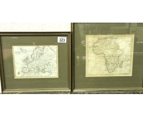


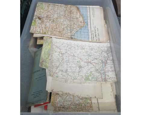
Lot 318
Box containing a collection of maps including: Isle of White Second War Revision 1940, Northampton Ordinance Survey map, England, Southwest Ordinance survey map, 4th edition. Midlands Map. Royal Automobile Club 1/4 inch map of England and Wales. Map or central London. Various other ordinance survey maps, Michelin maps. Derby and Leicester ordinance survey map 1954 etc (B.P. 21% + VAT)
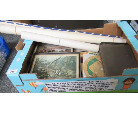
Lot 346
Selection of ephemera including address/account book from Towy Vale Colliery, Kestrel engine timer, admiralty map of St. George's channel, History of the French Invasion of Fishguard, workshop manual for Peugeot 404 1961-1970, workshop manual for Hillman Minx/Husky 1956-1965, two framed hunting prints, etc.(B.P. 21% + VAT)
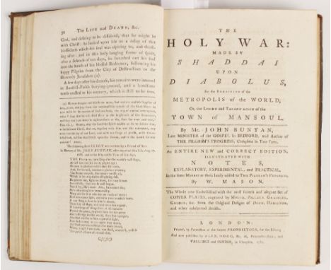
Lot 248
Bunyan (John), THE HOLY WAR: MADE BY SHADDAI UPON DIABOLUS, FOR THE REGAINING OF THE METROPOLIS OF THE WORLD, OR, THE LOSING AND TAKING AGAIN OF THE TOWN OF MANSOUL, first edition, full leather, gilt embossed decoration to spine, laid paper, hand-written bookplate to front free endpaper, engraved frontispiece, fourteen further engraved plates after Dodd, Hamilton and others including the foldout plate 8 (torn on crease), published by Alex, Hogg et al, London 1782, bound with AN AUTHENTIC ACCOUNT OF THE LIFE AND DEATH OF MR. JOHN BUNYAN... BY A FRIEND TO THE CAUSE OF TRUE RELIGION, together with Bunyan (John), THE PILGRIM'S PROGRESS: FROM THIS WORLD TO THAT WHICH IS TO COME, two parts bound in one volume, full leather, gilt embossed decoration to spine, laid paper, hand written bookplate to front free endpaper, engraved frontispiece, fifteen engraved plates after G. Burder (including foldout map), printed for Vallance and Simmons, London 1788 (at fault) (2)

Lot 27
Unexplored Syria Visits To The Libanus, The Tulu. Volume One & Volume Two. 1872. Sir Richard Francis Burton, Charles Frederick Tyrwhitt Drake. Published by Tinsley Brothers, London. First edition. 8vo. Lithographic frontispiece to each volume, folding map, 25 other lithographic plates (11 of which are) folding. two volume. 8vo. Contemporary half red banded spine, red morocco and cloth boards, top edge gilt. Lithographic frontispiece to each volume, folding map, 25 other lithographic plates (eleven of which are) folding.

Lot 61
A Description of British Guiana, Geographical and Statistical. 1840. Robert H. Schomburgk. Book published by Simpkin, Marshall, and Co. 155pp. advert 'to be published', 'twelve views of Guiana' by Schomburgk. hand-coloured folding map of British Guiana ( 2 small closed tears). 8vo. new half leather bind, with gilt letters to spine, new endpapers.


Lot 179
RALEIGH, Sir Walter - The Historie of the World : 8 double- page maps, early full calf worn but firm, folio, Eng. "Minde of the Front", and engraved title-page both torn with loss repaired as are several margins, and final page, folio, 1634. * maps in clean crisp condition, except map of Sicily which is a little chipped in the margin.

Lot 204
TURNER, Sharon - The History of the Anglo-Saxons : comprising the history of England from the earliest period to the Norman Conquest : 3 vols, large folding map, attractive half calf morocco label, 8vo. Longman, Hurst, Rees, et al, fourth edit, 1823. With - Mills, Charles, The History of the Crusades, for the recovery and possession of the Holy Land : two frontis. attractive half calf, extra gilt within compartments with contrasting morocco labels on the spine, 1828. With one other.(6)
Lot 225
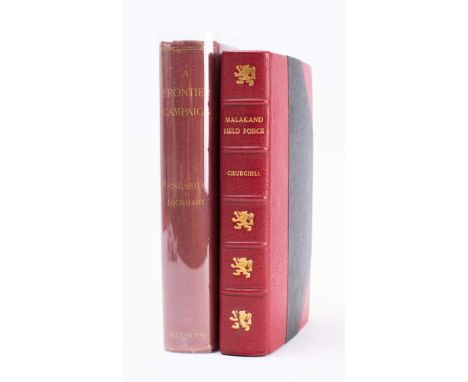
CHURCHILL, Winston Spencer - The Story of the Malakand Field Force an Episode of Frontier War : frontispiece, 2 fold maps, 4 sketch maps, well rebound in half morocco,8vo,1899 reprint from the Colonial Library Edition. * bound by Bayntun-Riviere.With - Fincastle, Viscount * Eliott-Lockhart, P. C. A Frontier Campaign a narrative of the operations of the Malakand and Buner Field Forces, 1897-1898. Fold map, 16 plates, org. cloth, 8vo, 1898.(2)


Lot 230
FORBES-MITCHELL- Reminiscences of the Great Mutiny 1857-59 : Org. cloth. 8vo, map, Macmillan's Colonial Library, 1897. With - Egerton, Wilbraham, A Illustrated Handbook of Indian Arms : maps inc. folding frontispiece, org. cloth, tall 8vo, 1880. With - Burke, W.S The Indian Field Shikar Book, cloth, oblong 8vo, 1908. With - Cook's India, Burma,and Ceylon, org. cloth,, 8vo,(1927). With a made up set of Heber's, Journey Through the Upper Provinces of India. With others relating to India.(15)

Lot 232
JENNINGS, Major J. Willes & ADDISON, Christopher - With the Abyssinians in Somaliland : folding map, plates, org. red cloth, 8vo, Hodder & Stoughton. With - McNeill, Captain Malcom, In Pursuit of the "Mad" Mullah. Service and Sport in the Somali Protectorate, plates, org. cloth, 8vo, Pearson, 1902. With, HMSO, Precis of Information Concerning Somaliland 1902, wrappers, With four others relating to Somaliland.(7)

Lot 236
PHILIP'S Library Map of British South Africa : large folding coloured map mounted on linen. size: 700 x 950 mm, cloth case worn on spine, no date (between the Wars?). With - Survey of India Offices, Road Map of India, large coloured folding map mounted on linen, size: 750 x 1000 mm, in worn cloth case,1942. With one other, and several large flat maps, colonial period. (a lot)

Lot 244
ATKYNS, Sir Robert - The Ancient and Present State of Gloucestershire : double-page county map, double-page city plan, double-page prospect of the City, eight pages of coats of arms, 61 double-page bird's eye views of county seats, cont. full-calf rebacked, folio, second edition, 1768 * contents clean

Lot 246
BACK, Captain - Narrative of the Arctic Land Expedition to the Mouth of the Great Fish River, and along the shores of the Arctic Ocean, in the years 1833, 1834, and 1835 : large folding map, 14 plates, org. cloth pulled at the head of the spine, one gathering has sprung leaving the fore edge of a few plates frayed not affecting the printed surface, stout 8vo, John Murray, 1836.

Lot 261
CURTIS, William Eleroy - Modern India : org. pictorial cloth, 8vo, Fleming H. Revell (US), 1905. With - Robertson, James (edit) Western India. Reports ... org. cloth (repaired), folding map, 8vo, 1853. With - Pascoe, Sir Edwin H. A Manual of the Geology of India and Burma, vol. one of four, org. cloth, tall 8vo, 1950. With others relating to India.(11)
Lot 265
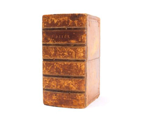
DEVON ORDNANCE SURVEY: ... The Second Part of the General Survey of England and Wales containing the whole of Devon and a portion of the adjoining Counties. Done by the surveyors of His Majesty's Ordnance, under the Direction of Lt. Col. Mudge - Large folding map in seven sections dissecting in to 24 segments to each section and mounted on linen. In original calf book box which is well rubbed. Overall size 2450 x 1850 mm, however two of the maps have been trimmed in the sea areas reducing the size of those two maps ( sheets 24 & 27 ) although none of the printed map is missing. Sheets 20, 21, 22, 24, 25, 26. 1809. * The earliest ordnance survey of Devon


Lot 272
GILBERT, C.S - An Historical Survey of the County of Cornwall : Cornwall : two volumes bound in three, one double-page map stained, 2 eng. title-pages, half title,47 plates inc. many aquatints, wood engravings, etc, inc. 25 plates of coats of arms, contemporary half calf spines either detached or nearly detached, 4to, 1817-20


Lot 289
MOORE, Thomas - The History of Devonshire ... illustrated by a Series of Views.Drawn and Engraved by and under the direction of William Keeble : 2 vols, County map with vignette by Scmollinger (dated 1836), Exeter plan, 90 steel engraved plates, 8vo, half calf contrasting morocco labels, c1823-36. * quite a nice copy still has all the attractive plates.
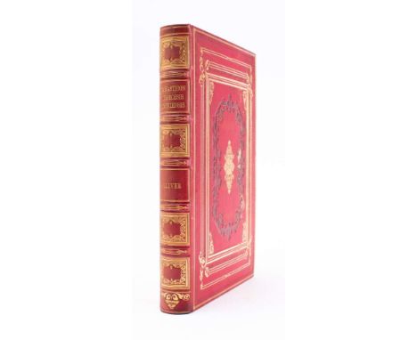
Lot 294
OLIVER, George - Monasticon Diocesis Exoniensis, being a Collection of Records and Instruments : ... in the Counties of Cornwall and Devon, [with] Supplement with large folding map, 2 colour printed plates, 3 lithograph plates, foxing, elaborate crimson and gilt morocco, Hannaford, Exeter, 1846* Supplement dated 1854.


Lot 426
CRESSWELL, Lieut. S. - A Series of Eight Sketches in Colour .... of the voyage of H. M. S. Investigator... the Discovery of the North-West Passage : 7 ex. 8 coloured lithographs published by Day & Son and Akermann, lacking plate "Bold Headland on Baring Island," size : 420 X 300 mm. With the map which is rather foxed. All framed & glazed, preserving the org. printed wrappers and text. 1834.* not examined out of the frames.(7)


Lot 450
PLYMOUTH : "The Environs of Plymouth, Stonehouse, and Devonport," hand coloured map, 395 x 270 mm, published by William Wood of Devonport, 1868. Attractive antique style gilt frame. With - Cooke, John, "Borough of Plymouth," hand coloured plan, 290 x 210 mm, attractive antique style gilt frame, 1820.(2)

Lot 457
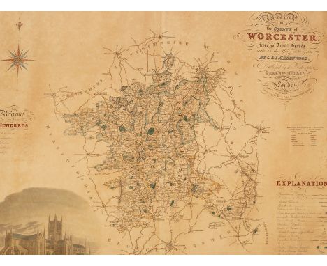
SPEED, John - Worcestershire Described : hand coloured map, size : 510 x 385 mm, Thomas Bassett & Richard Chiswell, English text, c1676, f & g. With another The Counti of Warwick the Shire Towne and Citie of Coventre described - John Sudbury & George Humble, English text, damage to lower part of the map. 1627, f & g(2)

Lot 462
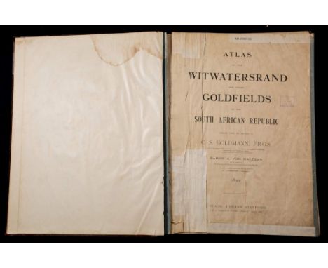
WITWATERSRAND GOLDFIELDS : "An Atlas of the Witwatersrand Goldfields in the South African Republic, compiled under the direction of C. S. Goldman ... and Baron A. Von Maltzan ..."Single page map, 40 of 42 full and double coloured plans of various estates, etc. It lacks two plans six and nine. The title-page, contents and index pages all heavily creased and poorly repaired ( the book has obviously had some extensive use) the actual maps apart from a few short tears are mainly in good order. Half morocco worn large title label on upper cover. Atlas : elephant folio, 770 x 590 mm. Published by Edward Stanford in London, 1899. * A used copy of a rare book, we have only found records of two being sold in the past 50 years. The Witwatersrand region, which forms a natural watershed between the Vaal and Olifants rivers is 40 km wide and extends for more than 100km. The thin bands of gold known as "reefs" are mined at depths of up to 3,050 meters. Founded as a mining settlement in 1886, Johannesburg already appears as a sizeable mining town 14 years later when this book was published, despite the Boer War (1899-1902) being in full swing. Colonized by the Boers, the Transvaal become independent in 1881. About this time gold was discovered. Interestingly this atlas was published with it's many lithographed maps during the first year of the war.Sold with the Atlas are eight of the original manuscript underground mine shaft plans of the " Great Hole of Kimberley." Which is the site of the World's greatest gold rush, the Kimberly Mine dates back to 1871.The plans drawn to scale are large for instance one titled 'A K 17' is folded and hand coloured mounted on linen dissecting into seventeen sections, it extends to 1338 mm. Indicating the progression of the height and length of the shaft. These historical precision documents provide a unique record


Lot 107
After C Warren : Durham Cathedral, North West View, engraving by B. Winkles, with hand colouring, 14 cm x 11 cm, together with five further colour topographical prints depicting local and other subjects, as well as a hand coloured steel engraved map showing the County of Durham, all parts in Hogarth-style frames. (7)


Lot 651
Star Wars 1990s/2000s and Space Precinct Action and Gaming Figures, all packaged, Star wars Power of the Force 2 by Kenner (8), Episode I (1) by Hasbro action figures, Wizards of the Coast Clone Wars, Attack on Teth trade box, of two figure map packs, (11/12), together with Space Precinct by Vivid Imaginations action figures (8) some discolouration to some figures, F-E, packaging G-E, (28)


Lot 425
Rubaiyat of Omar Khayyam translated by Edward Fitzgerald with illustrations by Gilbert James, The Thoughts of Emperor Marcus Aurelius Antoninus, London 1902, The Hums of Pooh & Fourteen Songs from When We Were Very Young by A A Milne, Baron Munchausen illustrated by Bichard, Hoyle's Games Improved, London 1778, The British Dance of Death (exemplified in a series of engravings) and various other antiquarian books & Bacon's Cycling Road Map of England & Wales on cloth


Lot 1087
Sir Wally Herbert (1934-2007)/Icewalk/limited edition print no 5 of 500/print, 38cm x 55cm/Sir Peter Scott (1909-1989)/Golden Eyes on Golden Water/limited edition print no 21 of 500/print, 38cm x 45cm/and a county Map of Worcestershire, all rolled and unframed/Note: being sold to benefit Stroud Court Community Trust CONDITION REPORT: Condition information is not usually provided in the description of the lot but is available upon request; the absence of a condition report does not imply that a lot is without imperfectionARR Artist's Resale Right may apply to the sale of this lot if the hammer price is the equivalent of 1000 Euros or more, incurring an additional fee. For further information please ask Chorley's or visit www.dacs.org.uk


-
109198 item(s)/page