

A General Chart of the West India Islands with the Adjacent Coasts of the Spanish Continent This attractive chart of the West Indies was drawn by Louis Stanislas Delarochette and published by William Faden in 1796. It extends to cover the southern tip of Florida and portions of Central America and northern South America. The map is extremely detailed, and filled with information on coastal features, soundings, shoals, anchorages and currents. Decorated by a simple, circular title cartouche. There are two 0.5"" tears in between Cuba and Central America that have been closed on verso with archival material, as well as a few extraneous creases and minor soiling. The centerfold has been reinforced to repair a few tiny separations and there are a few repaired edge tears confined to the blank margins. 20.6 W x 29.6 H Faden, William 1796
We found 109182 price guide item(s) matching your search
There are 109182 lots that match your search criteria. Subscribe now to get instant access to the full price guide service.
Click here to subscribe- List
- Grid
-
109182 item(s)/page
![Cuba Insula [on sheet with] Hispaniola Insula [and] Ins. Iamaica [and] Ins. S. Ioannis [and] I.S. Margareta This is a reduce](http://lot-images.atgmedia.com/SR/36385/2906594/348-20145813436_468x382.jpg)
Cuba Insula [on sheet with] Hispaniola Insula [and] Ins. Iamaica [and] Ins. S. Ioannis [and] I.S. Margareta This is a reduced version of the Mercator/Hondius folio map of important islands in the West Indies. This later re-issue of the Cloppenburgh plate omits the moiré pattern in the sea, and features several additions, including cartouches added to the distance scales and several sailing ships decorating the map. There is a small amount of printer`s ink residue mostly concentrated at the top of the sheet and a few insignificant spots. 7.4 W x 10 H Mercator/Cloppenburgh, 1676

Cuba Captivating map of the island is based on the cartography of Giacomo Gastaldi. The map includes Jamaica and part of Hispaniola. The Ye de Lagartos, shown north of Jamaica, is one of the earliest references to the Cayman Islands to appear on a map. The map was graphically engraved by Girolamo Porro, with a stipple engraved sea embellished with sea monsters, a sea turtle, a compass rose, and a title cartouche. It is from one of the most famous Isolarios (Island Books) produced in the 16th century. Printed on a full sheet (8.3 x 11.6"") of Italian text with a historiated initial; title above map, Descrittione Dell` Isola Cuba. A fine impression with some scattered foxing and minor soiling in the blank margins. 4.1 W x 5.6 H Porcacchi, Tomaso 1586
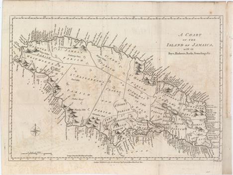
A Chart of the Island of Jamaica, with Its Bays, Harbours, Rocks, Soundings, &c. This striking map of Jamaica is divided into the counties of Cornwall, Middlesex, and Surry and subdivided further into a number of parishes. The map is teeming with detail along the coasts, with a myriad of bays, rivers, harbors, cliffs, coves, and the like named. In the water, reefs, anchorages, and soundings are shown. There is considerably less detail inland, although many mountains are depicted, including the Blue Mountains. A compass rose capped with a fleur-de-lis appears at bottom left. Engraved by John Lodge. This lot comes with the related four page article titled ""Discovery and Settlement of Jamaica..."" from the August 1780 issue of Political Magazine. Issued folding, now flattened, on watermarked paper with light offsetting and a couple fold separations that have been closed on verso with archival materials. There is a binding trim at right that has been replaced with old paper and an associated 2"" binding tear that has been closed with archival materials. 10.2 W x 15 H Bew, John 1780

S. Giovanni This captivating map of the island of Puerto Rico is based on the cartography of Giacomo Gastaldi. S. Croce (St. Croix) and Le Vergini (Virgin Islands) are shown to the east of the island and part of Hispaniola is depicted to the west. The map was graphically engraved by Girolamo Porro, with a stipple engraved sea embellished with a variety of sea monsters, a compass rose, and the title cartouche. This map is from one of the most famous Isolarios (Island Books) produced in the 16th century. Printed on a full sheet (8.3 x 11.6"") of Italian text with a historiated initial below the map and a title above it: Descrittione dell` Isola di S. Giovanni, detta Borichen. San Giovanni (San Juan) is the name that Christopher Columbus originally gave the island, honoring John the Baptist, and Borichen is its indigenous Taino Indian name. A bright, clean example. 4.1 W x 5.6 H Porcacchi, Tomaso 1586

Carte des Antilles Francoises et des Isles Voisines Dressee sur des Memoires Manuscrits This is Chatelain`s version of Delisle`s map of the Lesser Antilles that includes the interesting cartographic error of an upside-down Grenada. It extends from Guadeloupe to Grenada and includes Barbados. Numerous place names are shown, as are the locations of forts, churches, rivers, towns and villages. French text describes the European discovery and history of the islands. A dark impression issued folding on a watermarked sheet with light offsetting and a binding trim that extends to the neatline at top left. There are some chips and short edge tears along the left edge of the sheet, well away from image. 18.9 W x 12.9 H Chatelain, Henry Abraham 1719

Carte de de l`Isle St. Christophe This lovely map of St. Kitts is fully engraved with mountains, rivers, lakes, and towns. The island has twelve quarters and parishes, which are sometimes indicated by hand coloring, but not on this example. In the center of the island a note on the mountain Mont Misery locates Mines de Souffre. Grande Saline, Ville de la Basse Terre, forts, churches and more are identified. Decorated with baroque-style title and scale of miles cartouches and a fleur-de-lys, all fully colored. A nice bright sheet with light offsetting. 7.5 W x 12 H Bellin, Jacques Nicolas 1763

Guadaloupe, Done from Actual Surveys and Observations of the English, Whilst the Island Was in Their Possession with Improvements A sharply engraved map with tremendous coastal detail showing dozens of rivers, towns, forts, churches, and military batteries. Interior detail is limited to the expertly rendered topography. A legend below the title identifies anchorages for both large and small vessels. The map depicts Basse-Terre, Grande-Terre, Marie-Galante, and the Iles des Saintes. The island of La Desirade is erroneously shown north of Grande-Terre, rather than to the east. Published four years after Jeffreys death by Robert Sayer in the West India Atlas. A nice impression on heavy, watermarked paper with minor soiling and archivally repaired centerfold separations that enter 1/4"" at bottom and 1"" at top into map. Trimmed to neatline at top, with some loss of neatline, as issued. 18.5 W x 24.4 H Jefferys/Sayer, 1775

Map of the Virgin Islands, for the History of the West Indies This map of the Virgin Islands was made by Bryan Edwards, a Jamaican planter and politician, for his 1793 publication describing the West Indies. The map covers the area between Puerto Rico`s eastern shore and Anguilla, Saint Martin, and Saint Kitts, with all of the major Virgin Islands shown, including Saint Thomas, Saint Croix, and Tortola. Dozens of smaller islands are named, as are various bays, harbors, and points. Published by John Stockdale. A nice impression issued folding. 6.9 W x 8.9 H Edwards, Bryan 1794

Map of the Island of Tobago for the History of the West Indies A nice chart of the island showing its political divisions and considerable coastal detail. Topography is well developed. Published by John Stockdale. Issued folding on watermarked paper with marginal soiling and a few fold separations that have been closed on verso with archival tape, the longest of which enters about 1"" into the image. 7.2 W x 9.3 H Edwards, Bryan 1799

America Australis A crisply engraved map of South America filled with towns and pictorial representations of the mountainous topography. Near Guyana, the fictitious lake of Parime is named with the mythical city of Dorado shown upon its shores. A number of ships sail the seas, and the map is decorated with a cartouche showing the bounty of South America, including fat-tailed sheep. The scale of miles is topped with the symbol for the Society of Jesus. Heinrich Scherer, professor of mathematics at Munich, was a devout Jesuit. Many of the maps and plates in his atlas emphasize the Catholic hierarchy and the spread of Jesuit missions throughout the world. A bright, clean example with a dark impression and a tiny hole in southern South America. 9.1 W x 14.1 H Scherer, Heinrich 1699
![[Lot of 2] Carte de la Terre Ferme du Perou, du Bresil et du Pays des Amazones... [and] Carte du Paraguay, du Chili, du Detr](http://lot-images.atgmedia.com/SR/36385/2906594/368-20145813513_468x382.jpg)
[Lot of 2] Carte de la Terre Ferme du Perou, du Bresil et du Pays des Amazones... [and] Carte du Paraguay, du Chili, du Detroit de Magellan &c.... Fabulous matched pair of boldly engraved maps that together cover the continent. Size given is for each sheet, and varies slightly. Joined size would be 22.5"" x 38"". It is unusual to find these maps together.The northern sheet is filled with information and notations speculating about the Indian tribes and the tributaries of the Amazon. The capitaineries are shown along the coast of Brazil. A notation in Guyana notes the mythical Lac de Parime on which the golden city of Manoa del Dorado was supposed to be located. The central part of the map (Pays des Amazones) is filled with Indian names. The Inca Way (Grand chemin des Ingas) is shown from Chuquisaca in Peru to Pasto in Colombia. The title cartouche features mythical Amazon warriors, a pot of gold and King Louis XIV, as the Sun King.The southern sheet is filled with great topographical detail and notations throughout. The tracks of Magellan, Sarmiento, Brower, Beauchesne, Sharp, Sr. de la Roche, Halley and Vespucci are marked, and Amerigo Vespucci`s ship is shown sailing in the Atlantic. The title cartouche features the Notus (the south wind) and Native American figures. Fine impressions with original color on watermarked paper with a hint of offsetting. 19.3 W x 22.6 H Delisle/Covens & Mortier, 1730

A Map of Terra Firma. Guiana and the Antilles Islands This small map covers all of the West Indies and South America, north of the equator. In Guyana, the large, legendary Prime Lake is noted on the Equator, with the mythical city of gold, Manoa o el Dorado named on its shores. The tip of Florida is labeled Part of Louisiana and the Great Bahama Bank (Bahama Shoald) is clearly indicated. Published in London in Thomas Salmon`s Modern History: or the Present State of All Nations. Toned with light offsetting from an opposing text page. 7.1 W x 10.2 H Moll, Herman 1745

Terra Firma et Novum Regnum Granatense et Popayan Splendid map of the Isthmus of Panama and northwestern South America including most of present day Colombia and part of Venezuela. The map is based on the cartography of Hessel Gerritsz and formed one of the prototypes for South American cartography throughout the rest of the century. Jodocus Hondius engraved the map. After his death, Blaeu obtained the copper plate, added his imprint, and issued the map in a number of atlases. Two cartouches and a pair of compass roses dramatically decorate this map. French text on verso, published between 1638-43. Attractive color on watermarked paper with a hint of toning and light damp stains confined to far blank margins. 15 W x 19.3 H Hondius/Blaeu, 1638

Brasil Nuova Tavola This is one of the earliest maps of Brazil that is available to collectors. Though most of the maps in Ruscelli`s edition of Ptolemy are enlarged re-engravings of those found in the Gastaldi edition of 1548, there are four important, original maps including this one of Brazil. The map is oriented with north to the right. There are some coastal place names, but very little interior detail other than scattered rivers, mountains, forests and a large volcano. The interior is labeled Terra non Descoperta and there is a notation referring to cannibals (Gli indi natij di questi paesi mangiano carne humana). In later editions this notation is replaced with an illustration of cannibalism. This is the first state with the platemark running through the top margin. Latin text on verso.See also lot 732 for a complete first edition of Ruscelli`s Geographia. Light offsetting and tiny mildew stains in the image. 7.3 W x 10 H Ruscelli, Girolamo 1561

Brasilia Charming miniature map of Brazil with numerous place names along the coastline. A large spurious Lacus Eupama dominates the interior. Decorative title cartouche. Latin text on verso. This is from the first edition, with a mis-print of the title above the map (Descriptio Regni Chili). A dark impression and attractive color on watermarked paper with light toning. 3.9 W x 5.2 H Hondius/Bertius, 1618

Brazil A handsome and decorative steel engraved map showing the region in great detail. It features five vignettes, drawn by H. Winkles and engraved by W. Lacey: ""Boats on the Rio Negro,"" ""St. Catharina,"" ""Monte Video,"" ""Cape St. Antonio, Bahia,"" and ""Rio de Janeiro."" Surrounded by a delicately engraved decorative border. The map was drawn and engraved by J. Rapkin. Original outline color with marginal soiling. 13.7 W x 9.6 H Tallis, John 1850

Le Paraguay Subdivise en Ses Principales Parties, Suivant les Dernieres Relaons Boldly engraved map of the region of present day Paraguay, Uruguay, northern Argentina and southern Brazil. The Rio de la Plata is the main feature of the map along with the mountains and volcanoes of the Cordillera de los Andes. A drape-style title cartouche adorns the map. Engraved by Antoine de Winter. Watermarked paper with light printer`s ink residue. Narrow top and bottom margins, as issued. 8.2 W x 10.9 H Sanson, Nicolas 1683

Le Paraguay Tire des Relations les Plus Recentes Boldly engraved map of the region of present day Paraguay, Uruguay, northern Argentina, and parts of Chile and Brazil. The Rio de la Plata is the main feature of the map, which extends north to the mythical Lago de los Xarayes. The mountains and volcanoes of the Cordillera de los Andes are also prominently shown. There is good detail of topography, missions and villages. The decorative title cartouche is adorned with two female figures, fruit and flowers. On watermarked paper with original outline color in the map and later coloring in the cartouche. Light toning along sheet edges. 16.1 W x 21.5 H Sanson, Guillaume 1668
![[Lot of 2] Carte du Perou pour l`Histoire Generale des Voyages [and] 3e Feuille Suite de la Province de Quito au Perou A. C](http://lot-images.atgmedia.com/SR/36385/2906594/387-20145813546_468x382.jpg)
[Lot of 2] Carte du Perou pour l`Histoire Generale des Voyages [and] 3e Feuille Suite de la Province de Quito au Perou A. Carte du Perou pour l`Histoire Generale des Voyages, from Prevost`s Histoire Generale des Voyages, circa 1755 (8.2 x 14.5""). A nice map of Peru showing the coast from the Baye de Buenaventura that extends south to the border with Chile. There is excellent detail along the coastline, and many rivers are identified inland. A decorative title cartouche adorns the map. Engraved by Benard. Condition: Issued folding, now pressed, on watermarked paper with one small hole east of Lima. The binding trim at left has been replaced with old paper, and an adjacent binding tear has been archivally repaired. (B+)B. 3e Feuille Suite de la Province de Quito au Perou, from Le Petit Atlas Maritime , circa 1765 (14 x 7.4""). This map of northern Peru extends to present-day southern Ecuador. The map is filled with numerous small rivers and the Maranon River is well defined in the east. A few towns are also identified, including Loja (Loxa), Zaruma (Zarnma), and Paita (Payta). Adorned with a decorative title cartouche. Condition: On watermarked paper with minor soiling in wide margins. (A) See description above. Bellin, Jacques Nicolas 1755-65

Le Chili. Tire de Celuy que Alf. de Oualle P. de la C.d.I. a Fait Imprimer a Rome en 1646. Et Distingue en ses Treize Iurisdictions This important map of Chile, showing the Cuyo provinces (Chucuito), is based on the descriptions of Alfonso de Ovalle, a Chilean-born Jesuit. Ovalle created the first comprehensive history and description of Chile, which was published in 1646 and is extremely rare. This map is the first widely available edition of Ovalle`s map. Detail is primarily confined to the region west of the Andes, with numerous rivers and towns noted, including Santiago, Concepcion, and Valdivia. The map extends south to the Magellan Strait, and is graced with a lovely title cartouche that complements the scientific style of the cartography. Watermarked paper with original outline color in the map and later coloring in the cartouche. There is some scattered foxing in the image. 21.1 W x 15.2 H Sanson/Mariette, 1656

Falkland Islands and Patagonia Two maps within one decorative border. The map of the Falklands is very detailed and is surrounded by finely rendered engravings of penguins, sea birds, and tall ships anchored off Jason Island. The map of Patagonia has good detail along the coastline, but little in the interior. It has a large vignette of Christmas Sound in Tierra del Fuego with clippers under sail plus a small vignette of Fugeans in a boat. Illustrations by H. Winkles and engraved by W. Lacey, maps drawn and engraved by J. Rapkin. Original outline color with a hint of toning and some short edge tears, all well away from image, two of which have been closed along the bottom edge with archival tape. 13.5 W x 10.1 H Tallis, John 1850

Tabula Magellanica, qua Tierrae del Fuego, cum Celeberrimis Fretis a F. Magellano et I. Le Maire Detectis Novissima et Accuratissima Descriptio Exhibetur This is one of the most elaborately decorated maps to focus on the tip of South America with the Strait of Magellan and Le Maire Strait. The coastlines are depicted as very mountainous, while the interior is completely without detail. Instead the region is filled with a hunting scene, exotic birds including rheas and penguins, and a quaint scene of village life. The map is further adorned with a pair of compass roses, three sailing ships, and four beautiful cartouches. The key to the map is in a strapwork cartouche held aloft by putti, while the dedication cartouche at right is left blank. The cartouches arrayed across the bottom of the map present a unique distance scale in checkerboard format and the title with a tribe of Fuegian natives, penguins and shells. This is the first state with a blank verso. A dark impression with minor printer`s ink residue and a small, professionally repaired hole in border below penguins, with border expertly replaced in facsimile. 16.1 W x 20.8 H Jansson, Jan 1646

Carta Particolare del Mare di Ethiopia con l`Isola di S. Elena e Parte della Costa d`Affrica Carta VIIII This elegant sea chart is crisply engraved in the sparse Florentine style with superb calligraphy throughout. The map covers the islands in the South Atlantic centering on St. Helena and extending west to Ascension Island. The map extends to include two stretches of the African coastline, including portions of present-day Congo, Angola and Namibia. Sailing ships, a compass rose and a strapwork title cartouche embellish the chart. Short navigational notes are included throughout. This is the first state. Printed on two sheets, joined as issued.Robert Dudley was the first Englishman to produce a sea atlas, Dell Arcano del Mare (Secrets of the Sea). A skilled mathematician and navigator, Dudley was exiled from England and settled in Florence where his atlas was published. He introduced a totally new style for sea charts in the atlas with only lines of latitude and longitude and no rhumb lines. The charts were meticulously compiled from original sources and were both scientific and accurate for the time. This important atlas was the first sea atlas of the whole world; the first to use Mercator`s projection throughout; the earliest to show the prevailing winds, currents and magnetic deviation; and the first to expound the advantages of Great Circle Sailing. In an introductory leaf found in one copy in the British Library, the engraver states that he worked on the plates in seclusion for twelve years in an obscure Tuscan village, using no less than 5,000 pounds of copper for the printing plates. It was only issued in two editions and the maps are rarely seen on the market. A nice dark impression with light printer`s ink residue on bright, watermarked paper. A very fine example with just a touch of marginal soiling. 19.3 W x 30.3 H Dudley, Robert (Sir) 1646

Terra Nova, ac Maris Tractus circa Novam Franciam, Angliam, Belgium, Venezuelam Novam Andalusiam, Guianam et Brasiliam - Terra Neuf, en de Custen van Nieu Vranckryck, Nieu Engeland, Nieu Nederland, Nieu Andalusia, Guiana en Venezuela Magnificent sea chart of the western Atlantic Ocean showing the coastlines of North America from Cape Charles, Maryland to Newfoundland, and the West Indies to the northern coast of Brazil. The chart is based on that of Theunis Jacobsz, circa 1650, with few changes except for an improved (although still rudimentary) depiction of the Chesapeake Bay. Oriented by two compass roses with north to the left; the Azores and Cape Verde Islands are at the top of the map. It is richly decorated with two large cartouches with the title in Latin and Dutch. The central cartouche is surrounded by Mercury, a native riding an alligator, mermen and sea monsters. The corner cartouche with Dutch title features figures of explorers, natives, and exotic animals, including an armadillo. In the sea are sailing ships, including a raging sea battle, rhumb lines and two compass roses. This is the first state, with page 22 at top right.First published circa 1675, de Wit`s sea atlas, Orbis Maritimus ofte Zee Atlas, contained 27 charts from the North Pole to North and South America. The charts all appear to have been engraved by Romain de Hooghe and are splendid examples of Dutch marine works. The atlas was reprinted with amendments by Louis Renard in 1715, by Reinier and Josua Ottens in 1739 and 1745, and finally by the widow of van Keulen in 1802. A nice, dark impression with a few small spots of printer`s ink residue. There are professional repairs to a centerfold separation that enters 1"" into map at bottom, a 1"" separation along the upper centerfold only visible when held to light, a small hole and tear in Brazil, and a number of small tears and chips in blank margins. 19 W x 22.2 H Wit, Frederick de 1675

Canariae I. A charming miniature map of the Canary Islands, off the coast of Morocco. The map is handsomely adorned with a strapwork cartouche, a galleon, and two sea monsters. The majority of the maps for Bertius` geographical treatise were engraved by Jodocus Hondius Jr. after Mercator. French text on verso. A nice impression on watermarked paper with attractive color and one small spot to the left of the ship. 3.8 W x 5.3 H Hondius/Bertius, 1618

Carte des Isles Canaries, avec l`Isle de Madere, et Celle de Porto Santo This copper engraved map of the Canary Islands includes the islands of Porto Santo, de Madere, Tenerife, Palme, de Fer, de Canarie and Fortaventure. There are three distance scales including French leagues, marine leagues, and Spanish leagues. Issued folding on sturdy paper with a few faint spots. 12.6 W x 8.3 H Bonne, Rigobert 1787

Sancta Helena A handsome map of Saint Helena Island in the south Atlantic Ocean. The mountainous topography is depicted, along with a forested area and one dwelling. The map is handsomely embellished with a sea monster, ship, and an ominous title cartouche. The majority of the maps for Bertius` geographical treatise were engraved by Jodocus Hondius Jr. after Mercator. French text on verso. A dark impression with attractive color. 3.8 W x 5.3 H Hondius/Bertius, 1618

Islands in the Atlantic Beautiful steel engraved map consisting of four maps with six vignette views. Maps include the island groups of Cape Verde, Canary, Azores, Bermuda, and Madeira. Vignettes include Fayal, Villa Franca, and Pico (Azores), Chapel in the Rock St. Vicente (Cape Verde), Teneriffe (Canary Islands), and Funchal (Madeira). All surrounded in a delicately engraved border. Map drawn and engraved by J. Rapkin, illustrations drawn and engraved by H. Winkles. Original outline color with later color in the vignettes, a couple of insignificant spots in the image, and faint toning along the sheet`s edges. 13.9 W x 9.8 H Tallis, John 1850

Mappa Aestivarum Insularum, Alias Barmudas Dictarum, ad Ostia Mexicani Aestuary Jacetium... A striking map based on the famous survey by Richard Norwood of the Bermuda Company, also known as the Somers Isles Company, in 1618. The map shows the division into the original Tribes, which were a short-lived name for what became administrative parishes, and were names of major shareholders in the company. Also shown are the various landowners, with their names in a table below the map. There are many tiny houses shown on the map, locating settlements, as well as minute cannons marking the defensible points. The map is superimposed over a chart of the Atlantic with the coastlines of Britain, North America and Hispaniola showing the location of Bermuda. Decorated with an exquisite strapwork cartouche, a coat of arms, a medallion and a compass rose. Jansson reissued Hondius` plate with his imprint between 1647 and 1666. Spanish text on verso, published between 1653-66. A nice impression with wide margins and professionally repaired centerfold separations that enter into map 1"" at top and 2"" at bottom. There is minor soiling and a faint damp stain at left. 15.5 W x 20.4 H Hondius/Jansson, 1653

Islanda This wonderful little map of Iceland shows the island prior to when any actual surveys were completed. It reflects very sketchy knowledge of the island, which is shown surrounded by many smaller islands. The minutely engraved map features delightful depictions of topography and elaborate cities. Mount Hecla is shown as a flaming mountain and named Mons Helafiel. Several icebergs are shown floating off the coast. The map is oriented by a simple compass and adorned with a deftly engraved cartouche. Engraved by Girolamo Porro and printed on a full sheet (8.3 x 11.6"") of Italian text. A dark impression with marginal soiling and foxing, well away from image. 4.1 W x 5.8 H Porcacchi, Tomaso 1586

Tabula Islandiae Auctore Georgio Carolo Flandro This handsome copper engraved map of Iceland was based on information from a Dutch navigator named Joris Carolus in about 1620. The map shows the influence of both versions of Bishop Gudbrandur`s previous maps, a coastline resembling the Ortelius version, and Mercator`s selection and spelling of many place names. The island`s topography is dominated by huge mountains and volcanoes and its shoreline is a rugged labyrinth of fiords. It is richly embellished with title and distance scale cartouches, compass roses, rhumb lines, a sailing ship and two sea monsters. The cartouche features two winged sprites, an important symbol in Icelandic and Norse mythology. Along with elves and dwarves, sprites were magical beings who aided the gods. The map was first issued by Jodocus Hondius and then re-issued by Willem Blaeu with his imprint. It became the prototype for the mapping of Iceland and its influence did not wane until the mid-18th century. French text on verso, published between 1643-50. A fine impression with original color that has been partially refreshed and minor damp stains in the bottom blank margin. 15 W x 19.5 H Hondius/Blaeu, 1644

Carte de l`Islande pour Servir a la Continuation de l`Histoire Generale des Voyages. Dressee sur celle de M. Horrebows In 1752 the Danish scholar, Niels Horrebow, published an important book and map about Iceland. His map, based on the previously unpublished Knoff survey, was a major departure from previous maps based on Bishop Gudbrandur Thorlaksson`s map of more than 150 years earlier. Thus, it marked a turning point in the cartography of Iceland. This is Bellin`s version for Prevost`s important work on voyages of exploration. The map locates villages and churches and graphically delineates the mountains, rivers, lakes and forests. A note at bottom left explains that there are only two Episcopalian villages on the island, which are so marked, and that the term ""village"" on this map simply identifies a location where commerce occurs when ""the Danish negotiators arrive on the island."" Issued folding on watermarked paper with minor offsetting. The right margin has been extended with old paper to accommodate framing. 11.8 W x 14.9 H Bellin, Jacques Nicolas 1758
![[Lot of 3] Groenland [and] Novae Zemlae Delineatio [and] Delineatio Freti Vaigats This matched set of 3 miniature maps are f](http://lot-images.atgmedia.com/SR/36385/2906594/411-20145813631_468x382.jpg)
[Lot of 3] Groenland [and] Novae Zemlae Delineatio [and] Delineatio Freti Vaigats This matched set of 3 miniature maps are from Bertius` geographical treatise. Each map is beautifully engraved with a strapwork title cartouche and fully engraved seas. The majority of the maps for Bertius` geographical treatise were engraved by Jodocus Hondius Jr. after Mercator. French text on verso. Size varies slightly.A. Groenland. This handsome miniature map is one of the first maps to focus on Greenland. The island is shown as a narrow island with a central mountain range. Across the Fretum Davis is C. Bedford. Iceland is also shown with an erupting volcano.B. Novae Zemlae Delineatio. This charming miniature map shows the parts of Novaya Zemlya that had been discovered by western Europeans during their search for a northern passage to Asia. The first visit was by Hugh Willoughby in 1553. Then in 1596, Willem Barents rounded the north point of Novaya Zemlya, and wintered on the east coast near the northern tip. The map shows the western coast and northern tip of Novaya Zemlya according to Barent`s reports, and is decorated with two sailing ships and a raft of penguins in the sea, with a decorative title cartouche and compass rose.C. Delineatio Freti Vaigats. This miniature map shows the straits between mainland Russia and Vaygach Island, an area that was discovered by western Europeans during their search for a northern passage to Asia. The first visit was by Hugh Willoughby in 1553. Then in 1596, Willem Barents rounded the north point of Novaya Zemlya, and wintered on the east coast near the northern tip. At the time Vaygach Island was thought to be a part of Novaya Zemlya. The map is decorated with a sailing ship, compass rose, spouting whale, and a nice title cartouche. Very light toning and marginal soiling. 3.8 W x 5.3 H Hondius/Bertius, 1616

Europa Recens Descripta This classic map of Europe is presented in the carte-de-figures style with vignettes on three sides. The upper frieze has nine bird`s-eye views of Amsterdam, Prague, Constantinople, Venice, Rome, Paris, London, Toledo and Lisbon. The side borders contain the costumes of the noblemen and women of ten European nations. The map is embellished with sailing ships, sea monsters, bears and Neptune riding a dolphin and holding his trident. A beautiful map produced at the height of the Golden Age of Dutch mapmaking; it was included in the first volume of Blaeu`s magnificent atlas. French text on verso, published between 1643-50. A dark impression with original color that has been partially refreshed, light printer`s ink residue at left, and an expertly repaired centerfold separation that enters 2"" into map at bottom. The right and left margins have been extended to accommodate framing. 16.3 W x 22.1 H Blaeu, Willem 1643

Status Religionis Catholicae in Europa per Mappam Geographicam Proposit. This map of Europe shows the spread of Catholicism throughout the continent. A legend on a stone plinth at bottom left identifies cities based on their Catholic affiliation, including those that are part non-Catholic, and those where Catholicism has been introduced but is in decline. The magnificent title cartouche features a vignette of the Crucifixion, and the map is further embellished by sailing ships and sea monsters. A dark impression on a clean, bright sheet with attractive color. 9.1 W x 13.8 H Scherer, Heinrich 1702

Nouvelle Carte pour Servir a l`Histoire de l`Empire d`Occident Depuis les Premiers Empereurs Romains Jusques Apres les Successeurs de l`Empereur Theodose avec des Tables et des Remarques Trens Instructives This interesting map reflects the extent of the Roman Empire in Europe and northern Africa. The map features good topographical detail, and provinces, client states, cities, and rivers are named. There is an extensive key to important locations at bottom and a legend at upper left providing information on the governing hierarchy. A few historical and geographical notes in Latin appear within the map. A fine impression issued folding with a few extraneous creases, minor offsetting, and a hint of toning that is most noticeable in the blank margins. 19.9 W x 22.9 H Chatelain, Henry Abraham 1719

L`Europe Dressee sur les Observations de Mrs. de l`Academie Royale des Sciences et Quelques Autres; & sur les Memoires les Plus Recens Large, attractive map of Europe, including Iceland and the Mediterranean, based on the geography of Guillaume Delisle. The German Empire dominates all of central Europe, Poland takes in all of northeastern Europe, and the Turkish Empire occupies all of southeastern Europe. Fine decorative title cartouche. Alternative title above neatline at top: ""Nova Europe Descriptio in Regna & Regiones Praecipuas Divisae, ad Usum Serenissimi Burgundiae Ducis."" Original color on watermarked paper with minor soiling, a crease adjacent to centerfold at bottom, and a professionally repaired tear that just enters neatline at bottom. 18.9 W x 22.9 H Delisle/Covens & Mortier, 1730

Europa Secundum Legitimas Projectionis Stereographicae Regulas et Juxta Recentissimas Observationes Aeque ac Relationes... Decorative map of Europe with good detail throughout. It is based upon Haas` stereographic horizontal projection, which was featured in his book on cartographic methodology. Large decorative cartouche features Europa, crowns, horse heads, putti and the figure of Fame with her trumpet. A handsome chart that extends to include Iceland, the Mediterranean, and part of Northern Africa. French title L`Europe dessinee Suivant les Regles... is in top margin. Light soiling with a few very minor repairs and creases along the centerfold. 18.7 W x 21.8 H Haas/Homann Heirs, 1743

Das Under Buch Beschreibung Engellandts und Schottlandts This charming woodblock map of Britain is based on the Mercator-Ortelius outline and focuses primarily on England and Wales as the northern part of Scotland and the western part of Ireland are cut off by the borders. The map shows an unusual eastward slant to the mainland of Scotland. Only major cities are located and the topography is simplified. A small ship sails in the North Sea. German text on verso. A nice example with a faint stain along bottom neatline. 9.8 W x 6.8 H Munster, Sebastian 1578

Magna Britannia While the majority of the maps for Bertius` geographical treatise were engraved by Jodocus Hondius Jr. after Mercator, the individual maps of England, Scotland and Ireland were engraved by Salomon Rogiers after John Speed. This map depicts England, Wales, Scotland and a portion of Ireland, with great detail of towns and rivers throughout. French text on verso. A fine impression on watermarked paper with minor show-through of text on verso. 3.9 W x 5.4 H Hondius/Bertius, 1618

Britannia Prout Divisa fuit Temporibus Anglo-Saxonum, Praesertim Durante Illorum Heptarchia Elaborate vignettes depicting kings and scenes from Saxon history flank this magnificent map of Britain. The scenes are identical in subject matter to those used by John Speed. However they are presented in the dramatic, Dutch miniature style. The left border contains portraits of the earliest kings, while the right one depicts later kings in the process of conversion to Christianity. Included is a scene of Ethelbert receiving instruction from Saint Augustine and another of Sebert re-consecrating the temples of Diana and Apollo, now St. Paul`s, London and St. Peters, Westminster. The map shows England, Scotland and Wales divided into the various Saxon kingdoms, each decorated with its coat-of-arms. A superb example of Dutch cartographic design and engraving. French text on verso, published between 1645-48. A fine impression with full original color, light even toning, and professional repairs to a few small holes confined to blank margins. There is a printer`s crease in the bottom right vignette. 16.3 W x 20.3 H Blaeu, Johannes 1645

Britannia Romana This handsome map shows the British Isles during the era of Roman rule. Iron Age tribes are located, as are numerous towns. Hadrian`s Wall is depicted and various associated forts are named. The title cartouche is emblazoned onto a shield. On watermarked paper with light offsetting and remnants of cello tape on verso and along the edges on recto. There is moderate toning that is mostly confined to the blank margins. 13.9 W x 16.9 H Morden, Robert 1695

The North & East Riding of Yorkshire Copper engraved sheet with a map of Yorkshire, the largest county in England, occupying the lower two-thirds of the page. The top third of the sheet contains a mileage chart with the title The Road from Carlisle to Rarwick, enclosed in a beautifully engraved cartouche. Text along the bottom by John Owen describes the county`s layout, weather, and soil. An Ogilby-style strip map showing Northamptonshire and Warwickshire appears on verso, along with Northamptonshire`s coat-of-arms and descriptive text. A crisp impression on an unevenly toned sheet with a hint of offsetting from an opposing page. 7.3 W x 4.7 H Owen & Bowen, 1720
![[Lot of 4] London to Birmingham by Buckingham and Banbury [and] [Untitled - Road map from Wendover to Caughton] [and] A Map](http://lot-images.atgmedia.com/SR/36385/2906594/427-2014581370_468x382.jpg)
[Lot of 4] London to Birmingham by Buckingham and Banbury [and] [Untitled - Road map from Wendover to Caughton] [and] A Map of Buckinghamshire North West from London [and] Buckinghamshire A. London to Birmingham by Buckingham and Banbury, by Carrington Bowles, from Paterson`s Itinerary, dated 1785, black and white (3.5 x 6.5""). The recto of this sheet contains a strip map from Tring through Aylesbury to Bicester. The verso shows a strip map from Chalfont St. Peter through Amersham and Aylesbury to Padbury, just a few miles south of Buckingham. In the bottom margin on both sides are keys identifying the proprietors of various locations on the maps. Condition: A fine impression on watermarked paper. (A+)B. [Untitled - Road map from Wendover to Caughton], by Owen & Bowen, from Britannica Depicta or Ogilby Improved, circa 1720, black and white (4 x 6.2""). This strip map depicts the road from Wendover through Alesbury, Buckingham, Banbury, and Stratford upon Avon, to Caughton. Notes regarding each of the towns along the map are included, and on verso is the coat of arms of Banbury. Condition: Watermarked paper with very light toning. (B+)C. A Map of Buckinghamshire North West from London, by Thomas Badeslade, from Chorographia Britanniae, dated 1742, hand color (5.9 x 5.8""). This miniature map depicts Buckinghamshire showing roads, towns, rivers, and topography. At left is information for each of the towns regarding the number of members they send to Parliament and days on which there are markets and fairs. Condition: Light toning with remnants of cello tape along edges of sheet on verso. (B+)D. Buckinghamshire, by Anonymous, circa 1720, hand color (4.1x 4.1""). This tiny map of Buckinghamshire shows towns and includes a triangular distance table. Condition: A few spots of foxing. (B+) See description above. 1720-85

Map of the County of Middlesex, from an Actual Survey Made in the Years 1819 & 1820 This large and decorative map of Middlesex was published by the famous Greenwood firm. It depicts the region from London west to Uxbridge and north to Waltham Abbey. Large vignettes of Westminster Abbey and St. Paul`s Cathedral are illustrated in the lower portion of the sheet with a large compass rose above the map image. On watermarked paper with moderate soiling, two extraneous vertical creases to the left of the centerfold, and an edge tear confined to the right blank margin. 21.2 W x 25.6 H Greenwood Firm, 1829

Warwicum, Northhamtonia, Huntingdonia, Cantabrigia, Suffolcia, Oxonium, Buckinghamia, Bedfordia, Hartfordia, Essexia... Mercator`s great map of the southeast region of England including the British Channel and London. The map includes London, Kent, Oxford and Cambridge, as it covers the region between Norwich in the north and west to beyond the Isle of Wight. The sea is engraved in a moire pattern and the title is included in a fine strapwork cartouche. French text on verso, published between 1613-16. A nice impression on watermarked paper with very minor soiling and a few tiny wormholes confined to the blank margins. 14.4 W x 18.3 H Mercator, Gerard 1613

Anglia Regnum This fine map of England and Wales was copied from Willem Blaeu`s map and its decorations are nearly identical except that Jansson has added heraldic shields in Scotland and Ireland. It is decorated with four ships, a scale of miles flanked by sheep and a cherub, and two finely engraved coats of arms, of Great Britain and of England, surmounting the title cartouche. French text on the verso, published between 1645-46. A bright example with a fine impression, minor show-through of text on verso, and a professionally repaired 1"" tear in Glamorganshire. 15.3 W x 19.8 H Jansson, Jan 1645

A New & Accurate Map of North Wales, Drawn from a Late Survey This detailed map details six historic counties in northern Wales, from Anglesey down to Montgomeryshire. Roads, castles, rivers, and bays are identified, and cities, rectories, vicarages, fairs, and borough and market towns are indicated by symbols explained in a key at top right. A decorative title cartouche adorns the bottom left corner. Issued folding on a slightly toned sheet with light offsetting and some soiling mostly concentrated just outside the neatline at left. 7.2 W x 9.3 H Anon., 1766

Scotia This is one of the earliest printed maps of Scotland, with north oriented to the right of the page. The map is adorned with sailing ships, sea monsters, a compass rose, a stippled sea, and a title cartouche flanked by putti. Engraved by Girolamo Porro and printed on a full sheet (8.3 x 11.6"") of Italian text. Minor soiling in the blank margins. 4.1 W x 5.6 H Porcacchi, Tomaso 1586

Scotland This impressive map of Scotland features excellent detail of the counties, towns and cities, and topography. An inset in the upper right corner zeroes in on the Shetland Islands. Six vignettes drawn and engraved by J. Rogers surround the map, depicting the city of Edinburgh, men in the midst of deer stalking, an intense game of shinty, Holyrood House, and monuments to two of the nation`s most important writers, the poet Robert Burns and man of letters Sir Walter Scott. Enclosed in an elegant border. The map itself was drawn and engraved by J. Rapkin. On a clean, bright sheet with faint offsetting. 13.9 W x 9.9 H Tallis, John 1850
![[Lot of 2] Perth Kinross [and] Argyle This appealing pair of miniature maps focuses on Perth Kinross and Argyle, regions and](http://lot-images.atgmedia.com/SR/36385/2906594/446-20145813736_468x382.jpg)
[Lot of 2] Perth Kinross [and] Argyle This appealing pair of miniature maps focuses on Perth Kinross and Argyle, regions and former counties of Scotland. The Perth Kinross map is embedded in an elaborate illustration featuring a bolt of cloth, bird, waterfall, and fish (the area is known for its salmon and trout fishing). Within the map itself, towns, rivers, mountains, and a lake are identified. Engraved by Thierry. The Argyle map is surrounded by depictions of a waterfall, mallet, fishing net, sheep`s head, and bolts of cloth, and shows the string of islands that make up the region. Engraved by Migneret. Maps by Perrot are described by King as ""the most decorative miniature maps of the nineteenth century."" Size varies slightly. Each map has light scattered foxing. There are remnants of hinge tape on the verso of the Perth Kinross map. 4.3 W x 2.8 H Perrot, Aristide Michel 1823

Irlanda A charming small map of Ireland with north oriented to the right. The shape and geography of the country is quite rudimentary, with cities focused primarily along the coastline. The map is adorned with fantastical sea monsters, a compass rose, and a decorative title cartouche. Engraved by Girolamo Porro and printed on a full sheet (8.3 x 11.6"") of Italian text. On watermarked paper with minor show-through of engraving on verso. An ink notation and some scattered foxing appear along the sheet`s edges, well away from image. 4.1 W x 5.6 H Porcacchi, Tomaso 1586

L`Irlande Divisee par Provinces Civiles et Ecclesiastiques Decorative map with rococo-style cartouche and two distance scales. Good detail throughout the island particularly with towns, rivers and coastlines. Enclosed with an ornate picture-frame border. A strong impression with original color, some faint color offsetting, and a small rust stain confined to the lower blank margin. 10.8 W x 12.3 H Brion de la Tour/Desnos, 1766

Ireland This is a delicately engraved map of Ireland showing excellent detail of the provinces, towns, and cities as well as topography. The map is surrounded by lovely vignettes of St. Patrick`s Cathedral in Dublin, Limerick Castle, one of Ireland`s Holy Wells, Ross Castle on the Lake of Killarney, and the Round Tower in Wicklow. The beautifully engraved border is comprised of shamrocks, with a harp entwined in shamrocks at the bottom. Original outline color with light scattered foxing, faint soiling, and marginal toning. 13.7 W x 9.4 H Tallis, John 1850

A Plan of the River Lagon, and of the Intended Navigable Canal from Belfast to Loughneagh... This appealing map centers on the River Lagan and stretches from Lough Neagh to just northeast of Belfast. Various towns and cities, mills, bridges, and roads are shown. A chart at bottom right indicates the distance between various destinations in the area depicted. A compass rose orients the map with the north to the upper right hand corner. Issued folding with light offsetting. 6.8 W x 12.4 H Bowen, Emanuel 1778
![[Lot of 3] Suecia et Norvegia ect. [and] Gotia [and] Thietmarsia This matched set of 3 miniature maps are from Bertius` geog](http://lot-images.atgmedia.com/SR/36385/2906594/455-20145813754_468x382.jpg)
[Lot of 3] Suecia et Norvegia ect. [and] Gotia [and] Thietmarsia This matched set of 3 miniature maps are from Bertius` geographical treatise. Each map is beautifully engraved with a strapwork title cartouche and distance scale. The majority of the maps for Bertius` geographical treatise were engraved by Jodocus Hondius Jr. after Mercator. French text on verso. Size varies slightly.A. Suecia et Norvegia ect. This map depicts Scandinavia, extending east to include parts of present-day Russia and the Baltic states.B. Gotia. A lovely miniature map of southern Sweden delineating Gotland, Oland and the mainland from Stockholm south to below Vaxjo.C. Thietmarsia. This map shows the Holstein region in northern Germany, between the Eider and Elbe Rivers. The map is oriented with north to the left and features a moire-patterned sea. Very light toning, minor show-through of text on verso, and marginal soiling. 3.8 W x 5.3 H Hondius/Bertius, 1616

Suecia, Dania, et Norvegia, Regna Europae Septentrionalia... This fine map depicts the kingdoms of Sweden, Denmark and Norway, whose coats of arms are featured within the title cartouche. The map is attributed to Anders Bure (1571-1646), a Swedish cartographer and mathematician. Bure, also known as Andreas Bureus, is best known for his 6-sheet map of Scandinavia and for serving as the first director of the Swedish land survey. The Kingdom of Sweden is shown at its largest extent. The map extends to present day Finland and the Baltic states, and is filled with details of towns, political boundaries, rivers, and topography. This is the first state with French text on verso, published between 1643-50. A nice impression with original color that has been partially refreshed and faint damp stains in bottom blank margin that just enter map border in a few spots. 16.7 W x 20.9 H Blaeu, (Family) 1643

Scandinavia Complectens Sueciae Daniae & Norvegiae Regna ex Tabulis Beautiful folio map of Scandinavia, including the Baltic States with a portion of northeastern Russia, locates Moscow, S. Michael Archangel, Konigsberg, and more. Elaborate figurative cartouche features a herald, putti, angels, a lion, and royal coat-of-arms. Four distance scales at upper right. A nice impression with moderate toning along the centerfold, faint offsetting, and several small damp stains confined to the blank margins. 19 W x 22 H Homann, Johann Baptist 1720

La Suede, et la Norwege avec l`Islande... This attractive and nicely engraved map of Scandinavia presents the political divisions of each country with an inset of Iceland. The map is flanked by French text describing the area. The map, text and border were all printed from separate plates with the text adhered to the sheet by the publisher. The sheet with text measures 18.8 x 11"". A nice impression printed on bluish paper with very light toning along centerfold and edges of sheet. 9.2 W x 10.2 H Brion de la Tour, Louis 1786
-
109182 item(s)/page