We found 109182 price guide item(s) matching your search
There are 109182 lots that match your search criteria. Subscribe now to get instant access to the full price guide service.
Click here to subscribe- List
- Grid
-
109182 item(s)/page


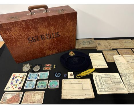
Lot 2207
WW2 British Argyl & Sutherland Highlanders group to Sgt R Ellis comprising of: Wooden suitcase with his name and rank: Argyl & Sutherland Highlanders Plastic Economy cap badge with tartan backing: Argyl & Sutherland Highlanders Metal cap badge with a perspex backing plate: Formation signs: RA Collar dog: 2nd Army Thanks Giving Service Book: Invasion Money x 5: His post war Civil Defence Beret with badge dated 1954: CD lanyard and cloth Instructors badge, CD Lapel badges in enamels: Message pad and NATO Alphabet and reporting Codes: LMS at War Book and Map: collection of cigarette card albums from the 1930's etc.


Lot 1730
John Senex (1678-1740), hand coloured map of the Island and Kingdom of Sicily, 51 x 59cm***CONDITION REPORT***PLEASE NOTE:- Prospective buyers are strongly advised to examine personally any goods in which they are interested BEFORE the auction takes place. Whilst every care is taken in the accuracy of condition reports, Gorringes provide no other guarantee to the buyer other than in relation to forgeries. Many items are of an age or nature which precludes their being in perfect condition and some descriptions in the catalogue or given by way of condition report make reference to damage and/or restoration. We provide this information for guidance only and will not be held responsible for oversights concerning defects or restoration, nor does a reference to a particular defect imply the absence of any others. Prospective purchasers must accept these reports as genuine efforts by Gorringes or must take other steps to verify condition of lots. If you are unable to open the image file attached to this report, please let us know as soon as possible and we will re-send your images on a separate e-mail.
Lot 1765
R. Bowyer - framed map of the Antilles Islands, 25 x 37cm***CONDITION REPORT***PLEASE NOTE:- Prospective buyers are strongly advised to examine personally any goods in which they are interested BEFORE the auction takes place. Whilst every care is taken in the accuracy of condition reports, Gorringes provide no other guarantee to the buyer other than in relation to forgeries. Many items are of an age or nature which precludes their being in perfect condition and some descriptions in the catalogue or given by way of condition report make reference to damage and/or restoration. We provide this information for guidance only and will not be held responsible for oversights concerning defects or restoration, nor does a reference to a particular defect imply the absence of any others. Prospective purchasers must accept these reports as genuine efforts by Gorringes or must take other steps to verify condition of lots. If you are unable to open the image file attached to this report, please let us know as soon as possible and we will re-send your images on a separate e-mail.

Lot 1834
Robert Morden (1650-1703), The Smaller Islands in the British Ocean, hand coloured map, sold by Abel Swale Awnsham and John Churchill, 37 x 43cm***CONDITION REPORT***PLEASE NOTE:- Prospective buyers are strongly advised to examine personally any goods in which they are interested BEFORE the auction takes place. Whilst every care is taken in the accuracy of condition reports, Gorringes provide no other guarantee to the buyer other than in relation to forgeries. Many items are of an age or nature which precludes their being in perfect condition and some descriptions in the catalogue or given by way of condition report make reference to damage and/or restoration. We provide this information for guidance only and will not be held responsible for oversights concerning defects or restoration, nor does a reference to a particular defect imply the absence of any others. Prospective purchasers must accept these reports as genuine efforts by Gorringes or must take other steps to verify condition of lots. If you are unable to open the image file attached to this report, please let us know as soon as possible and we will re-send your images on a separate e-mail.
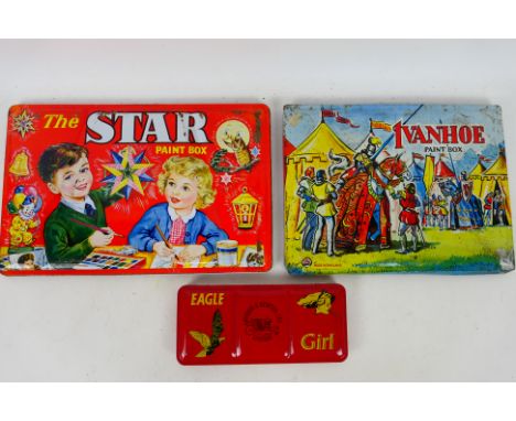
Lot 99
MAP - Windsor & Newton - Fred Liebetruth - Vintage Paint Tins / Pallets. A selection of Three vintage 1960's era, lithographed water colour tin paint sets appearing in Excellent condition with light scuffs and signs of rust appearing. Manufactured by MAP, Windsor & Newton and Fred Liebetruth, British makers of quality paint boxes with fine lithograph colours. Logo is featured on the lid or rear along with Made In England. Lithographer is unidentified. These manufacturers, much like Page London paint sets, typically depict children painting a scene of whatever they are observing at the time and display "Childhood memories". Lot consists of: Ivanhoe Paint Box by MAP with Jousting Scene 235mm x 312mm x 17mm. The Star Paint Box by Fred Liebetruth, Christmas Scene 234mm x 362mm x 18mm. Eagle Girl by Windsor & Newton with Eagle and Girl 101mm x 222mm x 21mm. All contain paints.(This does not constitute a guarantee). PLEASE NOTE: ALL ITEMS MUST BE PAID FOR AND COLLECTED OR DESPATCHED BY WEDNESDAY THE 13TH DECEMBER DUE TO THE HOLIDAY PERIOD.


Lot 82
DENNIS OPPENHEIM (1938-2011)Time Pocket 1968Signé et daté au milieu Technique mixteTirage argentique, graphite, carte, papiers imprimés.Getekend en gedateerd in het midden Gemengde techniekZilverdruk, grafiet, kaart, bedrukt papierSigned and dated in the middle Mixed mediaSilver print, graphite, map, printed paper101 x 78 cmFootnotes:Provenance / HerkomstGalerie Isy Brachot, BruxellesCollection privée / Privécollectie, BelgiqueIl pose ainsi le problème de l'intervention de l'homme dans la nature. Pour conserver des traces de ces interventions, il utilise la photographie ou le film cinématographique, posant dès lors le statut de l'utilisation de ces traces. Dennis Oppenheim donne un double statut à ses photographies et à ses films. Ils sont à la fois documents et œuvres. À partir de 1970, il utilise des photographies dans des collages de textes et de cartes. Ceux-ci sont suffisamment ouverts pour permettre au spectateur de réinterpréter l'intervention et de devenir à son tour un lieu d'expérimentation et de réflexion.For further information on this lot please visit Bonhams.com


Lot 2016
Worsley, Richard: The History Of The Isle Of Wight, London: Printed By A. Hamilton, 1781, engraved vignette to title, folding engraved map hand-coloured in outline, 31 engraved plates (including 12 double-page), engraved vignette illustrations, re-backed calf with gilt title, 4to, together with Barber, Thomas: Picturesque Illustrations of the Isle of Wight, original cloth with gilt vignette, engraved title (foxed), folding map and 40 plates, Sikkim and Marshall, London, 1834, 8vo. (2)Worsley – ends on page 274 with a large appendix following but no postscript page, end pages new, old repairs to title page, spotting throughout but generally not affecting text, tears and old repairs to map.


Lot 1333
Richard Blome (1635-1705) 'A Mapp of Ye Bishoprick of Durham' framed engraved map with hand colouring, 45.1cm x 39.7cm and 'A Plan of the River Tees and of the Intended Navigable Canal from Stockton by Darlington to Winston in the Bishoprick of Durham' survey'd by Robt. Whitworth, from Gent.Mag. Aug.1772, framed 37.4cm x 27.1cm (2)


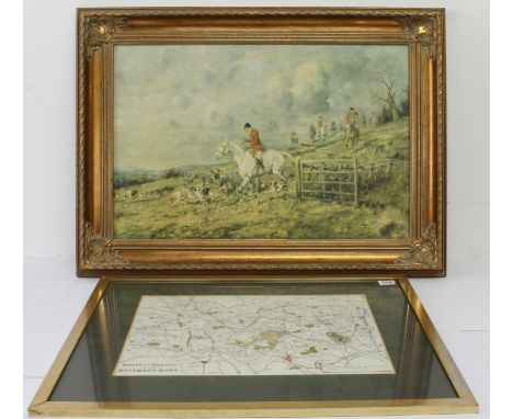
Lot 172
'Places of Meeting of the Heythrop Hunt', an engraved map with hand colouring - after Walker, originally pub. 1844, 20th century, scale 4in to1 mile, 12 x 15½in. (30.5 x 39.3cm.), modern gilt frame (51 x 58.5cm.); together with a gilt framed print of a hunting scene on canvas (frame size 54.5 x 75cm.). (2)


Lot 205
'Head of Christ' print on lacquered panel after Leonardo da Vinci - 20 x 16.5cm.; together with a 19th century 'Ladies of Llangollen' stipple engraving; a coloured portrait print of Marie Luisa de Tassis by Van Dyck; and a small hand coloured engraved bookplate map, 'Map of the various meets of the Belvoir Hounds'. (4)


Lot 394
Automobilia: two cased sets of Bartholomews road maps - 1920s-30s, comprising a cased set of 37 'England & Wales' maps (lacks no.13) and a cased set of 29 'Scotland' maps, both in mid-brown leather cases with plated locks, the England & Wales case with map measurer inside the lid, both with key.


Lot 408
Swiss, A.H. (pub): No.9 Hunting Map Showing the meets of Her Majesty s Buckhounds, The New Forest Deerhounds, Foxhounds at Chiddingfold, Goodwood, Hambledon etc. Large fold-out colour map in pictorial yellow boards, 1893, together with Davies, C.J: Ferrets And Their Management, nd. circa 1907 and Ferrets and Ferreting, Second edition nd. circa 1897. (3)


Lot 4320
Norfolk. Speed (John), Norfolk, a Countie Florishing & Populous Described and Devided with the Armes of Such Familes as have Borne the Titles Therof, John Sudbury & George Humble, circa 1627. Engraved map with hand colouring, inset town plan of Norwich, 'book' cartouche, 38 x 51cm Buckingham both Shyre and shire-towne describ.,engraved map with hand colouring, London: Thomas Bassett and Richard Chiswell, 1666 ,40cm x 53cm, Cumberland and the Ancient Citie Carlile Described with many memorable Antiquities therein found observed, John Sudbury & George Humble [1627], engraved map with hand colouring , inset town plan of Carlisle, 40cm x 51cm (3)

![Speed (John), Worcestershire Described, Thomas Bassett & Richard Chiswell [1676], hand-coloured engraved map, inset city plan](https://cdn.globalauctionplatform.com/10a5d5c4-f16d-4ded-92ff-b0c000e5cbe5/45c06fea-1fe7-4cf9-a5b8-b0d10132d3b9/468x382.jpg)
Lot 4321
Speed (John), Worcestershire Described, Thomas Bassett & Richard Chiswell [1676], hand-coloured engraved map, inset city plan of Worcester, strapwork cartouche and compass rose, plate 39 x 51cm, framed and double glazed; together with Morden (Robert), Map of Gloucestershire, hand coloured engraving, 36 x 43cm. Framed (2)Condition Report: Speed: Paper discoloured/foxed, central crease strengthened to reverse, needs cleaning. Morden: Unglazed, paper laid down, paper creased and crinkled, needs attention.

Lot 4322
Speed (John) & Norden (John), Surrey, Described and Divided into Hundreds, John Sudbury and George Humble, hand-coloured map engraved by Jodocus Hondius, plate 39 x 51.5cm. Framed and double glazed. Condition Report: Under glass, strengthening to centre crease, paper discoloured but colours good. Needs cleaning.


Lot 147
The Brittas Empire (BBC Sitcom 1991-1997 starring Chris Barrie by Andrew Norriss and Richard Fegen) - an original production used camera script for the Series 4 episode ' High Noon '. 78pp plus cover, scenes list, schedule, set map, running order and cast list pages. Complete script, with inset pink and blue pages. Signed to the cover by Julia St John (Laura) in blue ink.

Lot 8
From The Estate Of Tom Owen (1949-2022) - The Onedin Line (BBC Drama Series 1971-1980) - Tom Owen's personally used scripts and filming schedule for the Series 3 episode 'Ice and Fire' in which he appeared as the character 'Tom'. Comprising of two scripts for the episode - one with many annotations by Owen, the other presumably a spare and unmarked, along with a 'Block Filiming Schedule' for Episodes 6-9 with a locations map to the rear. A4. All in production used condition. The Onedin Line was a BBC television drama series that ran from 1971 to 1980. The series was created by Cyril Abraham. It was set in Liverpool from 1860 to 1886 and covers the rise of a fictional shipping company, the Onedin Line, named after its owner captain James Onedin. Around this, it depicts the lives of his family, most notably his brother and partner Robert, a ship chandler, and his sister Elizabeth, giving insight into the lifestyle and customs at the time, not only at sea, but also ashore (mostly lower- and upper-middle-class). The series also illustrates some of the changes in business and shipping, such as from wooden to steel ships and from sailing ships to steamships. It shows the role that ships played in such matters as international politics, uprisings and the slave trade.
Lot 22
HARDY, Thomas. Dorchester (Dorset), With Its Surroundings. Ordnance Map. 1st edition, 1905-1906. One of the Homeland Handbooks series (vol. 46).8vo., original printed wrappers.Foreword by Mr Thomas Hardy. Topographical plates. Housed in a blue cloth chemiseIncludes chapters on literature about William Barnes and Thomas Hardy, "Casterbridge" and a list of places mentioned by Mr Hardy in the Wessex Novels under fictitious names.Spine a little rubbed, otherwise good.With: 1 pp. als from Thomas Hardy in ink, Max Gate, 9/7/05 acknowledging receipt of the book and thanking the author,signed 'T. Hardy'.Exlibris of Carroll Atwood Wilson and the collector Frederick Adams, Jr.Provenance: Property from the library of a Dorset Gentleman.


Lot 789
A GEORGE III MAP SAMPLER 'MAP OF ENGLAND AND WALES' by S. Page, dated 1814, 47.5cm x 44cm (oval), framed and glazed, with a later label verso 'Worked by / Susannah Page / of Rivenhall (?) / Essex'. Condition Report : Generally good condition, with fresh colours; two small marginal holes lower left, not affecting design. Condition reports are offered as a guide only and we highly recommend inspecting (where possible) any lot to satisfy yourself as to its condition.
![Robinson [Joseph Barlow]: Robinson's Derbyshire Gatherings, 1866, pub. London: J.R. Smith, 36 Soho Square, containing portrai](https://cdn.globalauctionplatform.com/ad83c02c-e9c3-4075-a9d6-b0b300f0cfca/9385bef2-03fe-42df-8c35-b0cb00a7001a/468x382.jpg)
Lot 1293
Robinson [Joseph Barlow]: Robinson's Derbyshire Gatherings, 1866, pub. London: J.R. Smith, 36 Soho Square, containing portraits and memoirs of eminent natives and eccentric characters of the county of Derby, gilt tooled embossed maroon cloth; Bulmer's History and Directory of Derbyshire, 1895, by T. Bulmer & Co, with map prepared expressly for the work, maroon half calf (25s) and Lyson's Britannia, vol 5 Derbyshire, 1817, , pub London: T. Caddell and W. Davies in the Strand, with maps, half calf marbled boards. (3)
-
109182 item(s)/page