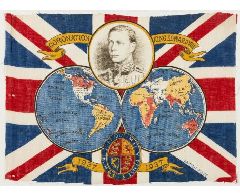
We found 109198 price guide item(s) matching your search

Refine your search

Year

Filter by Price Range
  • List
  • Grid
  • 109198 item(s)
    /page

Lot 235

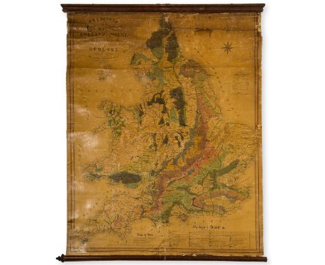
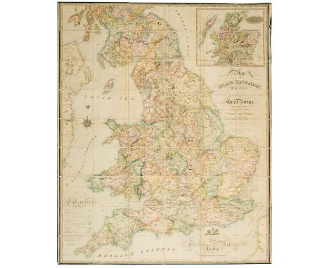
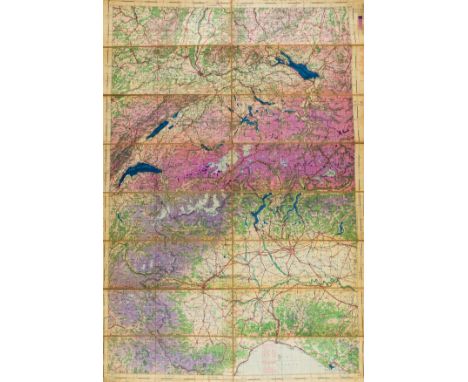
NO RESERVE British Isles.- Geological map.- Loader (T.B.) T. B. Loader's Scientific and Commercial Map of England and Wales in which are delineated the canals, rail-roads & navigable rivers, large calligraphic cartouche, compass rose, table of geological references and table of geological productions peculiar to each county and a table of explanation, fourteen geological cross sections, lithograph by W. Day, with hand-colouring, 1340 x 1100 mm (52 3/4 x 43 1/4 in), mounted on linen with old discoloured varnish, numerous areas of loss, splits, nicks and tears, rough edges, presented on contemporary wooden rollers, rolled, 1831.

Lot 178

Australia.- Hydrographic Office of the Admirality (British) Australia South Coast - Port Phillip, chart of Port Phillip Bay with Melbourne in the upper centre, surveyed by Lieutenants T.M. Symonds and H.R. Henry of H.M.S. Rattlesnake, with inset map 'The Entrance Channel Enlarged' in the lower right corner, engraving on wove paper without watermark, by J.& C. Walker, sheet 510 x 660 mm (20 x 26 in), carefully edged with linen, minor surface dirt, handling creases, unframed, June 13th 1838 with additions to 1842.

Lot 102

NO RESERVE Portugal.- Kinsey (Rev. W. M.) Portugal Illustrated; in a Series of Letters, double-page engraved frontispiece, 25 engraved plates, 14 hand-coloured, double-page engraved map, illustrations, 8pp. musical score, scattered spotting, contemporary calf, gilt, a little rubbed, 8vo, 1828.

Lot 285

Railways.- Bradshaw (George) Map & Sections of the Railways of Great Britain, with inset map of London in the lower left corner, engraving with some hand-colouring, 1650 x 1040 mm (65 x 41 in), dissected and mounted on linen, some light offsetting, spotting and browning, folding with marbled endpapers, green silk edges, contemporary purple straight-grain morocco, gilt and blind tooled with title to upper cover, rebacked, rubbed, 4to, 1839; together with 'Plan & Section of the Oxford & Great Western Union Railway with a branch to Abingdon', seven sheets of plans and sections with outline hand-colouring, loose, held within contemporary straight-grain morocco case with metal clasp, gilt lettering to flap, with GWR ownership label inside front cover, rubbed and slightly worn, oblong 4to, 19th century (2) ⁂ Bradshaw's first railway map.

Lot 286

Railways.- Early Cumbrian railways.- Stephenson (George) Plan and Section of the Maryport and Carlisle Railway in the Country of Cumberland, the plan only (lacking "Section), strip railway map, lithograph by Cheffins, with some outline hand-colouring, 305 x 2730 mm (12 x 10 7 1/2 in), dissected and mounted on linen, some losses, tears, nicks and surface dirt and stains, folding with cream endpapers, without slipcase, 4to, 1836; together with two others similar, including the earliest plan of the Furness Railway system, 'Plan and Section of an intended railway from Rampside and Barrow to Dalton and Ulverston and to the existing railway at or near Sandside', surveyed by J. Robnson Wright, and also with a similar plan titled 'Furness Railway 1846', including extensions to Broughton, Roe Island, and at Lindal, 860 x 1140 mm (34 x 45 in), and 710 x 150 mm (28 x 59 in), respectively, both dissected and mounted on linen, folding with marbled endpapers, 1840s (3)

Lot 168

America.- Stone (George W.) Geologic Map of North America, lithograph printed in colours, 980 x 1380 mm (38 1/2 x 54 1/4 in), minor nicks and tears to extremities, spotting and surface dirt, handling creases, unframed, rolled, published by the Geological Society of America, 1946; together with the U.S. Coast and Geodetic Survey's 'The World on the Azimuthal Equidistant Projection centered at New York City, published in Washington, 1949, and with the Washington Hydrographic Office's two-sheet 'World Chart', first edition, 1952 (3)

Lot 184

Central & Eastern Europe.- Mortier (Pierre) Estats De Pologne Subdivises suivant l'estendue des Palatinats Parle Sr. Sanson, large map of Poland, Lithuania, Ukraine, and part of Russia, first published by Hubert Jaillot in Paris based on the cartography of Nicholas Sanson, engraving with outline hand-colouring, on two sheets of laid paper conjoined, without watermarks, platemark 585 x 875 mm (23 x 34 1/2 in), sheet 660 x 1050 mm (26 x 41 1/4 in), some nicks and tears with small losses to extremities, occasional spotting and browning, minor handling creases, unframed, Amsterdam, [circa 1700].

Lot 17

NO RESERVE Asia.- Carruthers (Douglas) Unknown Mongolia, 2 vol., first American edition, half-titles, frontispieces, plates, illustrations, 6 maps (4 folding, 2 in text), pp.xv-xviii and folding map detached and loosely inserted, original cloth, gilt, slight bumping to corners and spine extremities, 8vo, Philadelphia, 1914.

Lot 225

NO RESERVE Switzerland.- Blaeu (Willem Jansz.) Das Wiflispurgergow, map of Southwestern Switzerland after Mercator, with ornamental title cartouche and showing Geneva, Lake Geneva, Lake Neuchatel, Lake Biel, Bern, Freiburg, Lake Thuner, and others, engraving with outline hand-colouring, 395 x 515 mm (15 1/2 x 20 1/4 in), under glass, presented in cassetta-style frame by Sebastian D'Orsai, [1647]

Lot 277

London.- Davies (Benjamin Rees) Davies' New Map of London and its Environs showing the New Railways, Stations & other Modern Improvements, large folding map of London, showing from Tottenham to Woolwich, and Lower Streatham to Hanwell, map affixed with text collage strips showing boundaries , engraving with hand-colouring, 730 x 1120 mm (28 3/4 x 44 1/8 in), dissected and mounted on linen, extensive splitting to folds, linen fraying, some browning, damp-stains and surface dirt, unframed, [Stanford's Geog Estab., 1887]; together with a good mixed group of 12 maps showing the environs of London, including Seale's 'New Map of the Countries Ten Miles round the Cities of London & Westminster...', two copies of Chatelain's 'Nouvelle Carte du Gouvernement Civil d'Angleterre', Thornton's ' A New and Correct Map of the Counties upwards of Twenty Miles Round London', and others, engravings, various sizes, all loose, some occasional nicks tears, and losses, all unframed, 18th and 19th century (13)

Lot 101

Polar.- Arctic.- M'Dougall (George F.) The Eventful Voyage of H.M. Discovery Ship "Resolute" to the Arctic Regions in search of Sir John Franklin..., first edition, half-title, folding engraved map with partial hand-colouring and routes supplied in red and blue, 8 tinted lithographed plates, some finished by hand with colouring of flags, wood-engraved illustrations, 24pp. publishers' catalogue at end, light spotting, old book-label of Thomas Kemp 1871 and bookplate of John R.Anderson, pencil note re restoration to front free endpaper, original cloth, rubbed, rebacked & recased preserving original spine, [Sabin 43183], 1857 § Kane (Elisha Kent) Arctic Explorations in Search of Sir John Franklin, wood-engraved plates, some double-page, and illustrations, some marginal staining, contemporary calf prize binding, rubbed, spine defective at head, 1892, 8vo (2)⁂ The Resolute set out as part of Belcher's relief expedition in 1850 but became stuck in the ice and was abandoned in May 1854. It was found by a American whaler, bought by the U.S. government and returned to Britain where it was presented to Queen Victoria. A desk was later built using its timbers and presented to the President of the United States in thanks; it is now situated in the Oval Office in the White House where it has been used by most of the intervening Presidents.

Lot 282

Railways.- Merret (H., Surveyor) Map of certain Intended Lines of Railway from St Helens to West Bank at Runcorn Gap..., manuscript plan, signed and dated by Merret, and also signed by the engineer, Charles Vignoles, the plan showing alternative routes for the proposed line with several branches, pen and ink, watercolour, 600 x 1850 mm (23 3/4 x 72 3/4 in), dissected and mounted on linen, several areas of small loss, repaired tears, surface dirt and stains, folding with purple-coloured endpapers, slightly worn, large 4to, 1829.

Lot 160

Polar.- Royal Geographical Society.- Sketch Map Showing Route of the 'Fram' and Nansen's and Johansen's Sledge Journey, leaflet map printed for the 'Nansen Meeting' held at the Albert Hall, 8th February, 1897, illustrating their North Pole journey, lithograph printed in colours by John Bartholomew, on thick wove paper, sheet 270 x 440 mm (10 3/4 x 17 1/4 in), old folds as issued, printed title verso, some careful repairs to old perforations within the map, visible verso, unframed, The Edinburgh Geographical Institute, 1897.

Lot 237

England & Wales.- Walker (John) Map of the Inland Navigation, Canals, and Rail Roads with the Situations of the various Mineral Productions throughout Great Britain, large detailed folding map with calligraphic title and dedication, compass rose and table of explanation, with inset map of Scotland in the upper right quadrant, engraving, an excellent crisp impression with with original hand-colouring, 1910 x 1570 mm ( 75 1/4 x 61 3/4 in), dissected and mounted on linen, some offsetting and light browning, edged with green linen, some edges a little rough, folding with marbled ends, ink stamp verso of 'Ministry of Transport and Civil Aviation Library', presented in contemporary book-style slipcase, gilt and blind tooled, scuffed and very worn, 4to, 1830.

Lot 216

Middle East.- Escape map on silk.- War Office (Geographical Section) Tabriz (verso); Tbilisi (recto), "restricted" military intelligence escape map, fifth edition, lithograph printed in colours on silk, sheet 540 x 610 mm (21 1/4 x 24 in), some surface dirt and abrasion, old folds, thinning in places, unframed, 1951.

Lot 148

World.- Morden (Robert) A New Map of ye World, double-hemisphere world map, engraving with hand-colouring on laid paper without watermark, platemark 95 x 170 mm (3 3/4 x 6 3/4 in), sheet 145 x 195 mm (5 3/4 x 7 3/4 in), minor spotting and surface dirt, unframed, [circa 1680].

Lot 210

NO RESERVE Italy.- Ortelius (Abraham) Perusini agri; exactissima nouissimáque descriptio: auctore Egnatio Dante, detailed map of Perugia, engraving on laid paper with watermark of crossed arrows, platemark 335 x 470 mm (13 1/4 x 18 1/2 in), sheet 450 x 585 mm (17 3/4 x 23 in), French text verso, central vertical fold, marginal damp-stains and surface dirt, some handling creases, unframed, [Antwerp, circa 1584]; together with Patavini Territorii Corographia, Iac. Castaldo Auct. [on sheet with] Apuliae quae olim Iapygia, Nova Corographia, engraving, sheet 450 x 580 mm (17 3/4 x 22 3/4 in), French text verso, central vertical fold, unframed, [Antwerp, 1598]; and Goritiae, Karstii, Chaczeolae, Carniolae..., engraving, sheet 445 x 280 mm (17 1/2 x 11 in), minor handling creases, light toning and surface dirt, unframed, [c. 1598] (3)

Lot 193

NO RESERVE Germany.- Ortelius (Abraham) Mansfeldiae Comitatus Descriptio. Auctore Tilemanno Stella Sig., regional map of Germany centered on Mansfeld and Eisleben, engraving with hand-colouring, platemark 370 x 430 mm (14 1/2 x 16 7/8 in), sheet 450 x 585 mm (17 3/4 x 23 in), French text verso, damp-stains to margin, nicks and tears to extremities, some handling creases, unframed, [Antwerp, c.1580]; together with three other Ortelius maps of Germany, including Franciae orientalis (vulgo Franckenlant) [on sheet with] Monasteriensis et Osnaburgensis episcopatus descriptio, and Braunsuicensis, et Luneburgensis Ducatum Vera Delineat. [on sheet with] Norimberg. Agri, Fidissima Descrip., and Buchaviae, sive Fuldensis Ditionis Typus... [on sheet with] Waldeccensis Comitatus Descriptio Accuratissima, engravings, each sheet approx. 450 x 585 mm (17 3/4 x 23 in), all unframed, [Antwerp, c. 1580]; and 2 others by Sebastian Munster and another compromised Ortelius map of Pomeraniae, Wandalicae Regionis Typ., all unframed, (7)

Lot 14

NO RESERVE Arctic.- Morrice (F. L. H.) The Nightless North: a Walk across Lapland, folding colour map at end, faint spotting, contemporary half-calf, slight bumping to spine extremities, Cambridge and London, 1881.

Lot 134

Atlases.- Lizars (Daniel) Lizars' Edinburgh Geographical General Atlas, 68 double-page engraved maps, hand-coloured in outline, with 1 double-page 'Tables of Mountain Chains' map, all mounted on stubs, some offsetting, occasional light soiling to margins, title with restoration visible, blindstamp of Uttoexter Mechanics Library, further blindstamps of Joseph Bladon, modern half calf, spine gilt, a little rubbed and scuffed, folio, [1842].⁂ Including the two rare maps depicting the Republic of Texas between its secession from Mexico in 1836 and its annexation in 1845.

Lot 179

Australia.- Harry Beck London Underground variant.- Commissioner for Railways (New South Wales) Railway Map, Sydney Suburban and City Underground Railway, first edition, lithograph printed in colours, sheet 165 x 245 mm (6 1/2 x 9 1/2 in), printed recto and verso, folds as issued, some spotting and browning, unframed, 1939.

Lot 273

London.- Schmollinger (W.) Improved map of London for 1833, from actual survey, showing from Islington across to the West India Docks, and Kennington to Paddington, including the proposed tunnel under the Thames at Wapping, and the Greenwich-to-London railway line, engraving on wove paper without watermark, sheet 470 x 625 mm (18 1/2 x 24 1/2 in), vertical and horizontal folds with splitting, numerous nicks and tears, one large tear repaired upper left, another not repaired lower right, others smaller and mainly to extremities, minor browning, unframed, 1833; together with 3 other maps of London, including Bowen's 'A Plan of the City and Liberties of London after the Dreadful Conflagration in the Year 1666', Vertue's 'A Plan of the City and Suburbs of London as fortified by Order of Parliament in the years 1642 & 1643', and a scarce copy of 'A Plan of the intended New Road from Padington to Islington' from the Gents Magazine, 1756, various sizes, all unframed, 18th century (4)Literature:[Schmollinger] Howgego 349, unrecorded state between (1) and (2)

Lot 281

Oxford.- Speed (John) Oxfordshire described with ye Citie and the Armes of the Colledges of yt famous University, county map, with inset town plan of Oxford, the vertical margins decorated with the heraldic shields of 18 of the Oxford colleges, engraving with hand-colouring, sheet 407 x 528 mm (18 1/2 x 20 3/4 in), central vertical fold with some splitting expertly repaired verso, some minor browning and surface dirt, minor nicks and tears to extremities with handling creases, unframed, Sudbury and Humble, [circa 1611-1627].

Lot 187

Europe upside down.- Münster (Sebastian) [Europa das ein Drittheil der Erden/nach Gelegenheit Unsern Zeiten], map of Europe, orientated in reverse with the north in the south, title trimmed from the upper margin, woodcut, sheet 258 x 340 mm (10 1/8 x 13 1/2 in), trimmed to borderline, old printers' creases, handling creases, minor surface dirt and browning, unframed, [c. 1540 or slightly later]

Lot 266

London.- Smith (Charles) Smith's New Plan of London, Westminster & Southwark, showing from Elephant & Castle to Islington, and Hyde Park to the East India Docks, with extensive key below featuring 350 alphabetical references, engraved map with outline hand-colouring, 420 x 740 mm (16 1/2 x 29 1/8 in), dissected and mounted on linen, surface dirt and browning, handling creases, folding without slipcase, 1818Literature:Howgego 225 unrecorded state between (11) and (12)

Lot 236

British Empire.- Anonymous. Coronation King Edward VIII, souvenir flag with a portrait of the King, a double-hemisphere world map with the British Empire coloured red, and the Royal Arms illustrated over a Union Jack background, colour-printed wood engraving on linen, 230 x 320 mm (9 x 12 1/2 in), small holes, minor surface dirt, unframed, [1936].⁂ The flag was printed in 1936 ready for the Coronation which was to take place the following year. However, Edward VIII chose love and marriage to Mrs Wallis Simpson rather than the throne and crown. Edward abdicated on 11th December 1936 and George VI was crowned instead.

Lot 174

NO RESERVE Asia.- Speed (John) A Newe Mape of Tartary, detailed map showing from Lake Baikal through the regions of present-day Manchuria and Siberia to the north of the Great Wall of China, with Korea as an Island, featuring 8 side panels with the people of Tartary in their native costume, and four vignette views above of Nova Zembla, and the silk route cities of Astrakan, Samarkand and Cambalu, engraving on laid paper without watermark, sheet 390 x 510 mm (15 1/4 x 20 in), trimmed to borderline, central vertical fold, minor nicks, unframed, Bassett & Chiswell, [1676]

Lot 263

London.- Horwood (Richard) Twenty map sheets from 'Plan of the Cities of London and Westminster, the Borough of Southwark and parts adjoining shewing every house', mainly sheets of the East London, including Whitechapel and Shoreditch, with six trimmed within the platemark but with full hand-colouring, the rest uncoloured with small margins, some duplicates, engravings, each sheet approx. 660 x 550 mm (26 x 21 3/4 in), or smaller, one sheet split completely along horizontal fold, others with splitting, nicks and tears, surface dirt, stains, and handling creases, all unframed, [1795] (20)

Lot 259

London.- [Rocque (John) and Richard Parr] Central section and parts of Rocque's 'An Exact Survey of the City's of London, Westminster ye Borough of Southwark...', includes 13 sections [not all in original sheet formats/sizes], with four sections that when conjoined show uniformly from Chiswick to Mile End, Islington to Dulwich, all centred on the River Thames and central London, the other sections of peripheral parts of the map, some duplicates, engraving, some sheets previously joined and later somewhat irregularly trimmed, each section approx. 470 x 630 mm (18 1/2 x 24 3/4 in), or smaller, a few with large splits and tears, some edges reinforced verso, handlng creases, nicks and tears, surface dirt, all unframed, [1746] (13)Literature:cf. Howgego 94

Lot 206

Ireland.- Nollin (Jean Baptiste) Le Royaume D'Irlande. Divise en Provinces Subdivises en Comtez et en Baronies ..., decorative Jacobite map of Ireland with large cartouche in the upper left corner, engraving with hand-colouring, on laid paper mounted onto paper support, sheet 660 x 480 mm (26 x 18 7/8 in), old folds visible, some minor marginal stains, surface dirt and browning, unframed, Paris, [circa 1690].

Lot 239

England and Ireland.- Speed (John) The Invasions of England and Ireland with al their Civill Wars Since the Conquest, decorative title cartouche surmounted by royal arms, upper right, naval battles in the Channel and North Sea, numerous land battles, large compass rose, arms of Scotland, Ireland and France, a text panel lower left, engraved map by Cornelius Danckerts, with hand-colouring, platemark 390 x 520 mm (15 1/4 x 20 1/2 in), English text verso, central vertical fold with careful repairs to splitting verso, marginal nicks and tears, some minor browning and surface dirt, with light exposure lines outside of borderline, unframed, Bassett & Chiswell, [circa 1676].

Lot 45

Europe.- Ireland (Samuel) A Picturesque Tour through Holland, Brabant, and part of France, 2 vol., second edition, aquatint vignette titles, 46 aquatint plates and 2 engraved plates, illustrations, short marginal tear repaired, occasional marginal damp-staining, strengthened hinges, contemporary half-vellum rubbed, soiled, 1796 § Gorse (Pierre) Les Pyrénées Monumentales et Pittoresques, tinted lithograph title, folding map, 45 hand-coloured lithograph plates, 7 double-page or folding, occasional marginal damp-staining, scattered spotting, original cloth, gilt, slight bumping to corners and extremities, chez Lafon, [c.1850] § Beattie (William) The Waldenses, or, Protestant Valleys of Piedmont and Dauphiny, engraved portrait frontispiece, additional engraved title, 70 engraved plates, 1 folding map, occasional spotting, previous owner's ink signature, contemporary morocco, a little rubbed, 1838; and others similar, v.s. (13)

Lot 208

Ireland.- Griffiths (Richard) and Thomas Larcom. A General Map of Ireland to Accompany the Report of the Railway Commissioners shewing the Principal Physical Features and Geological Structure of the Country, large detailed wall map presented in four sections, engravings with hand-colouring outlining counties, each sheet approx. 930 x 760 mm (36 1/2 x 30 in), dissected and mounted on modern linen, even toning to sheets throughout, some surface dirt, small repairs to nicks and tears, each section folding with marbled endpapers, marbled slipcase, large 4to, Hodges & Smith, Dublin, and James Gardner, [1839]⁂ Richard Griffiths produced the earliest geological maps of Ireland; this wall-map version was first published in 1839, while a reduced version was included in the Irish Railway Commission Atlas of the previous year.

Lot 132

De L'Isle (Guillaume) Atlante novissimo che contiene tutte le parti del mondo, nel quale sono esattamente descritti, first vol. only (of 2), engraved half-title, title printed in red and black ink, 26 engraved maps only (of 27, lacking the world map), some handling creases, occasional minor spotting and surface dirt, date scraped from title, contemporary limp board, ink title to spine, rubbed and scuffed, spine splitting at upper section, folio, Giambattista Albrizzi, [circa 1740-1750].

Lot 203

India.- Allen & Co. (William H.) Map of India, from the most recent Authorities, engraved map, by [?]J. Walker, with early hand-colouring, sheet 970 x 850 mm (38 1/8 x 33 1/2 in), dissected and mounted on linen, some spotting and browning, with minor offsetting, folding with buff end panel into contemporary gilt and blind tooled boards, some scuffs and splitting to spine, lightly worn, 8vo, 1844.

Lot 209

Ireland.- Heffernan (Daniel Edward) Heffernan's Illustrated Plan of Wicklow &c., tourist's map showing from Dublin in the upper right corner to Corey in the south, border decorated with 22 vignettes of local scenery and beauty spots, engraving, the map with hand-colouring, sheet 635 x 510 mm (25 x 20 in), folding with printed 'Important information for Tourists' endpaper, one fold splitting, other minor splits to edges, some spotting, browning and surface dirt, folding into original green cloth covers, with gilt title 'Heffernan's Pictorial Plan of Wicklow and Environs of Dublin', embossed, minor rubbing, 8vo, 1861.⁂ Rare. WorldCat records two copies in American institutions (University of Illinois, and University of Kansas). We could not trace any other copies coming up for auction.

Lot 175

Central Asia.- Stanford (Edward) Stanford's Large Scale Map of Afghanistan showing the Present British Frontiers, lithograph with some hand-colouring, 825 x 990 mm (32 1/2 x 39 in), dissected and mounted on linen, minor spotting and surface dirt, folding with marbled endpapers into red cloth slipcase, publisher's printed label to upper cover with owner's inscription 'W.G. Baynton', rubbed, 8vo, 1880.

Lot 241

Aviation charts.- War Office (Geographical Section) Collection of 17 military aviation charts of England & Wales, France, and parts of Belgium, Netherlands, and Italy, all with numerous topographical details, altitudes, and distances, offset lithographs printed in colours, various sizes, all dissected and folding into uniform burgundy covers, each with printed label of Sifton Praed & Co. affixed to upper covers, labels with manuscript description of regions covered, many front pastedowns with stamp of 'B.L. Bathurst', [early 1940s]; together with 2 further aviation charts of England and Wales, with flip-through sections, and a complete set of 11 folding maps from the 'Automobile Association General Flying Map Quarter Inch Ordnance Survey', many with contemporary annotations, all with yellow printed labels to upper covers, all loose, presented in metal box, [mid 20th century] (Sm. qty.)Provenance:Pilot active in World War II; by descent to the present owner.

Lot 197

NO RESERVE Greece.- Speed (John) Greece, engraved map with hand-colouring, on laid paper with armorial watermark, sheet 397 x 514 mm (15 3/4 x 20 1/4 in), central vertical fold with repairs to splitting, and some associated abrasion and loss to lower central section, repaired tear visible in the upper right corner, marginal nicks and tears with repairs verso, some minor browning, damp-staining and surface dirt, unframed, Bassett & Chiswell, [circa 1676].

Lot 142

Atlases.- World.- Sharman (John, Dublin-based publisher) [Sharman's Geography], without title [? as published], 31 engraved maps, one folding, including a double-hemisphere world map, the Americas, Asia, China, India, East and West Indies, each leaf approx. 205 x 360 mm (8 1/8 x 14 1/8 in), on wove paper each with watermark date of '1810', several sheets with numerous tears and handling creases, some edges reinforced verso, otherwise scattered surface dirt and marginal nicks and tears throughout, with original brown paper wrappers present, extensive ink marginalia to both upper and lower wrapper, modern endpapers, modern half calf, marbled boards, contemporary red morocco label to upper cover with gilt initials 'H.G.', oblong folio, [circa 1794 to 1810].⁂ Scarce at auction. WorldCat records only one other copy, held in the British Library, which has only 24 maps present. Another copy is found in the Library of Congress where 29 maps are included.

Lot 100

Polar.- Arctic.- Barrow (John) A Chronological History of Voyages into the Arctic Regions, first edition, half-title, large folding engraved map, 3 wood-engraved illustrations at end of Appendix, map a little offset, some light browning, contemporary half calf, rubbed, joints split, spine ends worn, [Hill 67; Sabin 3660], 8vo, 1818.

Lot 196

NO RESERVE Germany.- Wilckens (C.) Special Karte von dem Fürstenthum Hildesheim und den angrenzenden Landern, rare map of the Hildesheim principality in northern Germany, engraving with hand-colouring on laid paper without watermark, sheet 765 x 620 mm (30 1/8 x 24 1/4 in), central horizontal fold, minor nicks to extremities, some handling creases, unframed, [Hanover], 1804.

Lot 219

Poland.- Seutter (Matthäus) Borussiae Regnum, with inset map of the Principality of Neufchatel, large decorative cartouche centered on a portrait of Frederick William, King in Prussia, engraving with original hand-colouring, platemark 505 x 580 mm (19 7/8 x 22 3/4 in), wide margins, some rough edges, minor surface dirt, unframed, [c. 1730].

Lot 280

Northampton.- Saxton (Christopher) Northamton Bedfordiae, Cantabrigiae, Huntingdoniae et Rutlandiae ..., strapwork title cartouche surmounted by the royal arms, upper left corner, arms of Thomas Seckford to the lower left corner, large compasses, scale and banderole lower right corner, engraved map with original hand-colouring, on laid paper with watermark of a bunch of grapes, platemark 400 x 530 mm (15 3/4 x 20 7/8 in), sheet 410 x 545 mm (16 1/8 x 21 1/2 in), laid onto very fine conservation tissue support, central vertical fold with two small areas or splitting expertly repaired verso, further minor repairs to marginal nicks and tears, minor browning and surface dirt, unframed, 1576.

Lot 9

Africa.- Treatt (Stella Court) Cape to Cairo: the Record of a Historic Motor Journey, first edition, signed and inscribed by author, small photo of author and her husband loosely inserted, frontispiece, plates, folding map, occasional faint spotting, original cloth, slight bumping to corners and spine extremities, 1927 § Grogan (Ewart S.) & Arthur H. Sharp. From the Cape to Cairo, first edition, portrait frontispiece, plates and illustrations, 3 maps (2 folding), scattered faint spotting, related newspaper cutting loosely inserted, original pictorial cloth, expert repairs to spine ends and lower joint, a little rubbed, 1900 § Treatt (Major C. Court) Out of the Beaten Track, first American edition, frontispiece, plates, small hole to title, not affecting text, previous owner's ink signature to title, original cloth, lightly sunned spine, slight bumping to corners and extremities, New York, 1931, 8vo (3)⁂ The first is a record of the first successful journey by car from south to North Africa.

Lot 213

Middle East.- Cheesman (Major Robert Ernest) Arabia. Routes between 'Oqair and Jabrin Oasis in Eastern Nejd, map of an ornithological expedition in Saudi Arabia, with inset map showing Arabia during the campaign and unification of Saudi Arabia, lithograph printed in colours on wove paper, sheet 505 x 620 mm (19 7/8 x 24 1/4 in), some small repairs to old folds, repaired tear with small loss to centre left edge, Marylebone Public library stamps verso, unframed, 1925

Lot 186

China.- Second Opium War.- Anonymous (probably The British Admiralty Office) Plan of the Mouth of the Pei-ho River [Hai River, Beijing], manuscript outline map showing the Taku Forts, British and French fortifications alongside numerous waterways and roads, pen and black ink, watercolour on large sheet of handmade Chinese laid paper, without any watermarks, 690 x 850 mm (27 1/4 x 33 1/2 in), large loss to central section, old folds and handling creases, numerous nicks and losses, mainly to edges but some within the sheet, remains of silk edge to lower and lower left edge, minor surface dirt, unframed, [circa 1860]⁂ The present map conforms closely to the topographic information found in the printed map Pei-Ho or Peking River Sheet 1 From Entrance To Ko-Ku from a survey by Mr. A.E. Ploix Engenieur Hydrographe of the French Imperial Marine 1858.

Lot 226

Switzerland.- Homann Heirs (publisher) Canton Glarus sive Pagus Helvetiae Glaronensis cum Satrapia Werdenberg recenter delineatus per Gabrielem Walserum, map of the Canton Glarus, with vignette of a mountainous scene and inset map of Werdenberg, engraving with original hand-colouring, platemark 460 x 570 mm (18 x 22 1/2 in), good margins, minor handling creases, unframed, 1768.

Lot 155

World.- Cook's Voyages.- Roberts (Lieut. Henry) & Robert Benard. Carte Generale Offrant Les Decouvertes Faites Par Le Capitaine Jacques Cook, French edition of a detailed world map including tracks of all three voyages of Captain James Cook, engraving with hand-colouring, sheet 615 x 930 mm (24 1/4 x 36 1/2 in), laid onto linen support, numerous old folds and handling creases, slightly rough edges, a few small repaired tears, some marginal abrasion, minor spotting and surface dirt, unframed, [circa 1785].

Lot 66

India.- Tupper (Charles Lewis) Our Indian Protectorate, bookplate of Henry Crossley Irwin to pastedown, original cloth, light sunning to spine, spine ends and corners a little bumped, covers a little mottled, 1893 § Baxter (Rt.Hon. W.E.) A Winter in India, chromolithographed frontispiece, folding map, plates, original cloth, spine a little sunned and chipped at head, 1882, first editions, presentation copies "With the author's compliments" to half-titles, 8vo (2)⁂ A scarce pair, both presentation copies.

Lot 98

Polar.- Peary (Robert Edwin) Nearest the Pole, first English edition, frontispiece, plates, folding map at end, scattered faint spotting, original cloth, gilt, slight bumping to corners and spine extremities, 1907 § Mikkelsen (Ejnar) Lost in the Arctic, first edition, frontispiece, plates, folding map at end, modern decorative cloth, modern slipcase, 1913 § Astrup (Eivind) With Peary Near the Pole, first English edition, portrait frontispiece, illustrations, cracked hinges, original decorative cloth, gilt, slight bumping to corners and spine extremities, 1898, 8vo (3).

Lot 214

Middle East.- Saudi Aramco (publisher) El Hasa, large detailed wall map focussed on the Persian Gulf, one sheet from a larger set, lithograph on thin wove paper, sheet 1350 x 1000 mm (53 1/4 x 39 1/4 in), central horizontal fold, even toning to sheet, some browning and surface dirt, small losses to lower section, marginal, unframed, [circa 1950]; together with the British Hydrographic Office's 'Persian Gulf, Western Sheet', lithograph, 1040 x 710 mm (41 x 28 in), unframed, rolled, [c. 1942] (2)

Lot 83

Middle East.- Howard (Alexander) Howard's Guide to Jerusalem and Vicinity with map of Palestine, portrait frontispiece, folding map, spotting, advertisements at end, faint damp-staining to endpapers, original cloth, rubbed, slight bumping to corners and spine extremities, Jaffa, Jerusalem, Howard's Hotel, 1888; and a later edition of the same, 8vo.⁂ Rare.

Lot 170

South America.- Seale (Richard William) A Map of South America with All the European Settlements & Whatever Else Is Remarkable from the Latest & Best Observations, decorative map identifying European and Indian cities, forts, castles and gold and silver mines, engraving with hand-colouring, sheet 480 x 390 mm (18 7/8 x 15 1/4 in), minor spotting and browning, unframed, [1764]; together with four further continent maps of South America, including maps by Thomas Kitchin, Thomas Bowen, Samuel Dunn, and Russell, engravings, some hand-colouring, various sizes, all unframed, 18th and 19th century (5).

Lot 215

Middle East.- War Office (Geographical Section) Aswan, detailed military map of the region, lithograph printed in colours, 630 x 760 mm (24 3/4 x 29 7/8 in), minor handling creases, rolled, 1951; together with two other similar maps of the region, one covering 'Damas (Damascus)', and the other a heliozincographed map of ' Lower Mesopotamia' by the Survey of India Offices, Calcutta, various sizes, some spotting and browning, old folds and handling creases, unframed, rolled, early to mid-20th century; and with W. & A.K. Johnston's 'War Map of the Middle East, illustrating the Campaigns in Persia, Mesopotamia and the Caucasus', 570 x 880 mm (22 1/2 x 34 3/4 in), folding with numerous splits and tears, handling creases, unframed, [1916] (4)

Lot 113

West Indies.- Bermuda.- Stark (James H.) Stark's Illustrated Bermuda Guide, plates and illustrations, folding map, ink inscription to pastedown, original pictorial cloth, light rubbing to extremities, 1902 § Redman (J. Law) Isles in Summer Seas (Beautiful Bermuda), frontispiece, illustrations, upper hinge tender, original cloth, pictorial onlay, some light damp-staining, 1913; and 3 others, Bermuda, 8vo (5)

Lot 207

Ireland.- Beaufort (Daniel Augustus) A New Map of Ireland Civil and Ecclesiastical, First edition, large title and vignette in the upper left corner, engraving with outline hand-colouring, in two sections, each section approx. 560 x 880 mm (22 x 34 3/4 in), dissected and mounted on linen, trimmed to borderline, handling creases, surface dirt, some offsetting and browning, folding without slipcase, 8vo, 1792.

Lot 284

Railways.- Stephenson & Sons (George) Plan of a Proposed Rail-way from London to Birmingham, 9 lithographed map sections, from parliamentary plans, each approx. 385 x 645 mm (15 1/8 x 25 1/4 in), each linen backed on stubs, corners cut, minor handling creases and surface dirt, limp cloth boards with printed label to upper cover, oblong elephant folio, [c. 1833]; together with two bound related works, including 'Book of Reference' to the plans, and 'Acts relating to the London and Birmingham Railway 1833-1837', uniform black cloth, rubbed, 4to, [c. 1833] (3)⁂ The 112-miles London and Birmingham Railway was the first intercity line from London, opening throughout in 1838.

Lot 122

Britain.- Cary (John) Cary's Improved Map of England and Wales, with a considerable portion of Scotland, planned upon a scale of two statute miles to one inch, engraved title, 65 map sheets and index map, engraved maps with original hand-colouring, sheets each c.530 x 680mm., with hand-coloured engraved 'Explanation' key leaf tipped in at beginning (sometimes missing), soiled, many sheets torn and frayed at edges (repaired), some trimmed with loss of imprint, engraved bookplate of John Beames, contemporary half pigskin, worn, lacking spine, oblong folio, 1832; sold not subject to return

Lot 247

East Midlands.- King (William) A Map of a Tract of Country Surrounding Belvoir Castle including extensive Districts of the Counties of Leicester, Lincoln & Nottingham; and the whole of the County of Rutland, engraved map with outline hand-colouring, on 4 sheets, not joined, each sheet approx. 670 x 860 mm (26 1/4 x 33 3/4 in), wide margins, old folds, handling creases and surface dirt, unframed, William Faden, [1806].

Loading...Loading...
  • 109198 item(s)
    /page

Recently Viewed Lots