We found 109182 price guide item(s) matching your search

Refine your search

Year

Filter by Price Range
  • List
  • Grid
  • 109182 item(s)
    /page

Lot 117

After Richard Blome - "Map of Hartfordshire with its hundreds by Ric Blome" , hand coloured, dedicated to " To the Rt Hon James Cecill Earl of Salisbury...." 25 x 32 cms , framed and glazed,The British Gazetteer - map of Essex , published for the proprietors , by H.G. Collins - 36 x 42 cms, framed and glazed and"Plan of the Regent's Park " engraved by J Cleghorn, published by Jones and Co. 1827, 21 x 23.5 cms , framed and glazed (3)

Lot 118

Quantity of maps published by British Columbia and Vancouver Island, Denmark, Turkish Empire, Canada, Newfoundland, United States of America the North Central Section, Algeria, Russian Empire, South American States New Grenada and Venezuala, North East Africa, Egyptus, Egypt x 2, Bowles-Bowen strip map and a map of Gloucestershire by John Carey 1801 

Lot 20

Rudge, The Rev. Thomas"The History of the County of Gloucester; compressed and brought down to the year 1803", 2 vols. printed for the author by G.F. Harris Gloucester 1803, folding map frontis, Vol.1, folding plate,"A Pedestrian Tour through North Wales" the Colburn Publisher 1838, etchings by A. Clint, musical scores, folding, offsetting foxing and staining, half-leather marble boards, backstrip with loss and bumped,Lysons, Rev. Daniel and Lysons, Samuel"Magna Britannia ... The Several Counties of Great Britain" , Volume 6 Devonshire, Thomas Cadell 1822 and Volume 6, Part 2 Devonshire, not complete, missing map, various plates, full leather, gilt rules and tooled decoration, front board separated on Part 1 and separating on Part 2, bookplate inside front board, backstrips with gilt titles and raised bands (bought as seen) (5)

Lot 284

WWII RAF silk escape map, sheet 43A and 43B.  The Pyranees East  Central, France (North West), Belgiun (West and Central), Holland (part of), German, Swiss Frontier, France (South West), Span (North)

Lot 30

Dewhurst, Henry W."Barclay's Universal English Dictionary", newly revised, George Virtue [1850], frontis portrait Queen Victoria, vignette on title page, 48 uncoloured engraved County maps and Town Plans by Thomas Moule, uncoloured engraved portraits, rebound by Bayntun of Bath containing the original receipt dated 1977, marbled end papers, the front board is detaching and stitching can be seen both inside and out, raised bands, gilt paste down with titles, lined stamped tooled decorations to edges, and one copy of The Tatler, Volume the Third 1774 and Salmon, Mr [William Salmon] and Kitchin"The Modern Gazetteer or Short View of the Seven Nations of the World" to include a folding World Map frontis and four other folding maps, re-backed, full leather, red pastedown with gilt titles (3)

Lot 190

After G. COLLINS. An antique coloured seat chart map of Rye Harbour “To The Honble. Robert Austen Esq….This Mapp is most humbly Dedicated and Presented by Capt. Greenvile Collins”. 17¾” x 11½”; & a re-printed map of “Londinium Feracissimi An Gliaei Regini Metropolis”, 14½” x 20½”, each framed & glazed.

Lot 133

Railway related items, including repro poster framed, repro Flying Scotsmann cast iron plaque, LMD plaque and a map.

Lot 216

The County of Northampton as Surveyed and Planned by Geographer to The King, and engraved by William Faden, 1779, second edition, 1791, on three sheets, together with frontis, together with a facsimile of Bryant's Map of the County of Northampton, rolled.Qty: 2Condition report:The William Faden sheets are loose and rolled in a hard card tube but they do stick out one end. That being said the edges are not too tatty or worn. The sheets are previously been folded with evident fold lines when looking at the back of each of the sheets. The Frontis sheet has a 5cm tear along one of the old fold lines from the right hand margin and seems to have once have had an old taped repair. Similar smaller shorter tears to some of the other sheets. Sheets have a generally good even colour and no significant staining. Extra images on the image reel show each sheet of the Faden.

Lot 300

1930s Japanese propaganda map of East Asia and the Pacific, published 1934/35, detailing the Japanese Pacific strategy showing troop numbers, aircraft numbers, American convoy and patrol routes, with insets of Manchuria, Hawaii pre-Pearl Harbour, San Fransisco, Vladivostock, and the Panama Canal, 79x108cm.Condition report:It is in a fairly modern frame - we've not taken it out to inspect but there are evident issues. Previously folded into 16ths. All over heavy foxing and spot discolouration. Evident losses to the paper particularly on the crease lines with obvious losses to the centre, patches of tears and losses to the Pacific below the Californian coast, losses below mainland Japan, losses along the crease line just above the insets, and smaller spot losses elsewhere. Some wear and losses to the margins. It has been backed against what looks to be a blue card which is a close colour match to the ocean, so where there are losses you see a similar blue through the holes.

Lot 343

After John Speed,Leicester, both Countye and Citie described...hand coloured map,41x53cm, framed and under glass,and after John Ogibly, The Road from London to Darby.Qty: 2

Lot 142

A colour map, Northumberland in the times of the Norman conquest, in a black and gilt frame, together with a black and white picture depicting figures in 19th century dress on Windsor Terrace, in oak frame and mount. (2)

Lot 259

A Framed and Coloured Map of Staffordshire by Richard Blome, 33x24cms

Lot 217

SWANEE WHISTLE OR LOTUS FLUTE, two harmonicas and other mixed collectables to include a small extending tripod, vintage map measure and a pocket magnifying glass

Lot 95

JOHN SPEED antiquarian map of Anglesey in black and white, 41 x 55cms and another antique engraved map of Wales, Isle of Man and the Irish Sea, a similar size

Lot 948

Four hand coloured maps to include: Robert Morden (c.1650-1703), 'Leicestershire' engraving on paper, 43 x 36 cm; William Henri Toms (c.1700-c.1755), 'A Map of Herefordshire', engraving on paper, 16 x 16 cm; 'Lancashire' by J & C Walker, 43 x 35 cm; and 'Cheshire' 26 x 20 cm, all framed and glazed (4)

Lot 961A

Boer War cotton handkerchief printed with portraits of Lord Roberts and Queen Victoria with a map of Southern Africa and Kipling's 'The Absent Minded Beggar' with music by Arthur Sullivan, 44.5 x 43cm, in painted frame and glazed

Lot 1654

An antiquarian map of the County of Kent Divided into its Lathes, by Eman Bowen 1736 together with an early 19th century map of Italy (2)

Lot 1668

A box of mixed ephemera to include various vintage pamphlets, a war time cookbook, Illustrated dated week ending October 28th 1939, autograph book and the "Land & Water" map of the war by Hilaire Belloc and a map of Belgium issued by the War Office July 1912, etc (1)

Lot 1776

A collection of assorted maps to include various ordnance survey maps, a framed rail road and township map of Wyoming, a late 19th century Atlas of The British Isles, various plates from the Times Atlas, etc (4)

Lot 154

John Speed - an early hand coloured map of The Isle of Wight

Lot 22

An antique map by ROBERT MORDEN of Nottinghamshire, a JOHN SPEED hand coloured antique map of Yorkshire, together with two others

Lot 571

A Brannon map of the Isle of Wight - framed and glazed, together with other Isle of Wight maps

Lot 645

A JOHN SPEED antique map - 'Wight Island' - 40cm x 52cm CONDITION REPORTwe believe this to be originalCondition disclaimerOur team of trusted experts are on hand to help and always endeavour to provide an accurate judgement. The ultimate responsibility lies with the buyer however, and we recommend that you make every effort to inspect the lot yourself.To that end, we have provided a number of additional images for your attention.

Lot 213

Garmin GPS Map 64S hand held GPS receiver.

Lot 410

Nikolas Visscher (1618-1709)Topographic map, Brabantiae Ducatus cum adjacentibus Provinciisca. 1690, 60x50 cm, outer size 83x73 cm

Lot 412

Topographic map, Hollandiae Meridionalis Pars I, Constinens Novissimam, Delflandiae, Schielandiae doro Stepanum Swart, 45x55 cm, outer size 69x79 cm

Lot 9323

Framed topographical map of Friesland, emphasis, 53x62 cm and faceted mirror in walnut veneer frame with edge decoration, part of which is missing, 54x50 cm

Lot 226

BOTERO, Pe. Giovanni, S.J.- LE | RELATIONI | VNIVERSALI | DI GIOVANNI BOTERO | BENESE, | DIVISE IN QUATTRO PARTI. | [...] | Con le Figure in Rame: ¶ vna Aggiunta della Descrittione del Mare.- In Venetia : Appresso Giorgio Angelieri. M. DC., [1600].- [32], 256, 80, [24], 152, 183, [9, 16], 79, [1 br.] p.: il.; 20 cm.- E., Giovanni Botero (ca.1544-1617), Jesuit, Italian diplomat and intellectual, born in Bene Vagienna (Piedmont), in 1589 published his main work in Venice with the title “Della ragion di Stato”, in which he contrasts a Christian vision Machiavelli's amoral political philosophy. His equally popular “Relationi universali”, originally published between 1591 and 1598 and reprinted many times, contains descriptions of the main countries and regions of the four continents. Illustrated edition with four folding maps (double page), copperplate printed, representing the four continents: Europe, Asia, Africa and America. Copy a little cropped and carefully washed; sheet Cc3 with restored tear, no lack of support; second map is loose. Recent binding, complete with flexible parchment, with ties, according to the taste of the time. Sabin, 6804/5. Borba de Moraes, 114. Brunet, 1143.

Lot 257

VOULTON, Mons.- Verdadeira e exacta noticia dos progressos de Thamas Kouli Khan Schah [sic] da Persia no Imperio do Gram Mogol, escrita em lingua Persiana em Delby em 21. de Abril de 1739. e mandada a Roma por Mons. Voulton. Accrescentada com outras chegadas por varias partes, com hum Mapa do Thesouro do Gram Mogôr levado de Hispahan pelo mesmo Schah.- Lisboa Occidental: Na Officina de Antonio Correa Lemos, 1740.- 19, [1 br.] p.; 20 cm.- E., First edition [and only?] of a report recounting the military campaign of the Shah of Persia, Thamas Kouli Khan (1688-1747), against the Mughal Empire of South Asia. The pamphlet includes not only a translation of the original Persian, written in Delhi by Voulton in 1739, but also other documents and a description of the Mughal treasure (Map of the Spoils) captured in the expedition (p. 16/17), including the imperial throne studded with diamonds. Little is known about the author, apart from having deserted the French army in Pondicherry (India) to enlist in the Persian forces. Last leaf with minor imperfections. Recent binding, full sheepskin. Leaflet not registered in the consulted bibliographies. Laurence Lockhart, “De Voulton’s noticia”, in Bulletin of the School of Oriental Studies, University of London 4:2 (1926), pp. 223-45. Apparently only two copies are known in Portugal, one in the National Library, the other in the BGUC.

Lot 258

JACOB, William.- Travels in the South of Spain, in letters written A. D. 1809 and 1810.- London: printed for J. Johnson and Co., 1811.- XIII, [3], 407, [1 br.], 36, [7, 1 br.] p.: XIII gravuras desdobr.; 28 cm.- E., The author (1762?-1851), who spent six months in Spain (1809/1810), has based on letters he wrote to family and friends. Original edition, illustrated with a map of Cádiz (with a panorama of the city) before the beginning of the text and 12 more engravings, printed separately, 11 of which are hand-coloured aquatints and a contour etching. Copy slightly trimmed, with slight browning that did not affect the prints. Contemporary fine calf half-binding, undamaged on covers, with Atkinson label, Salisbury. Palau, 122598. Foulché-Delbosc, 244.

Lot 262

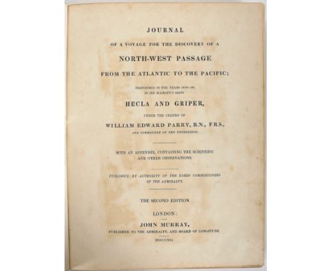
PARRY, Cap. William Edward.- Journal of a voyage for the discovery of a north-west passage from the Atlantic to the Pacific; performed in the years 1819-20, in His Majesty’s Ships Hecla and Griper, under the orders of William Edward, R.N., F.R.S., and commander of the expedition. With an appendix, containing the scientific and other observations.- The second edition.- London: John Murray, 1821.- 2 vols.: il.; 26 cm.- E., Sir William Edward Parry (1790-1855), English explorer, born in Bath, became famous for his travels in the Arctic, in an attempt to find the famous Northwest Passage, a feat that would only be achieved in 1906 by the Norwegian Roald Amundsen. The collation of the two volumes is as follows: I - [8], XXIX, [3], 310, [2], clxxix, [1] p.: XX engravings and maps; II - XXVI, [1], 186, [2], 151, [1] p.: [11] engravings and maps. Complete copy, with all 31 illustrations, according to the respective indexes (except in print XV, next to the title page and in the first map, on p. XXIV), nine aquatints (vol. I), six steel engravings (vol. II), 10 maps (5 splits) and six engravings with profiles of Arctic levels (1 splits). Copy slightly trimmed, with some browning, but generally clean. Cut at the fold of the fold-out map on p. 29, resulting from the trim; map XVIII badly folded; some imperfections along the backbone on the first and last leaves of each volume. White stamp from the J.G. Mazziotti Salema Garção Bookstore, on both front pages. Recent bindings, complete in green morocco, with closed panels on the smooth spines, rolls on the squares and top gilt edges. Protective cases.

Lot 1175

A collection of drawings, depicting ships, portret and landscapes, 17th/18th centuryMap bestaande uit tekeningen met o.a. schepen, portretten en landschappen, 17e / 18e eeuw

Lot 1731

MENDES MARIA (1948), sig. l.l. and dat. '87, Nude study, hereby 8 nude studies, all sig. and dat. ink on paper, 32 x 47 cm.MENDES MARIA (1948), gesig. l.o. en gedat. '87, Naaktstudie, hierbij map met 8 naakt studies, allen gesig. en gedat. inkt op papier, 23 x 47 cm.

Lot 1711

LEIBOVITZ, EDWARD (1946), signed l.r. Jewish scenes, screenprint, edition 16/150, 66,5 x 44,5 cm, set of 4, including folder. (Leibovitz is known for his glassworks like the windows in the Portugese Synagogue in Antwerp) (4x)LEIBOVITZ, EDWARD (1946), gesign. r.o. Joodse scenes, zeefdruk, editie 16/150, 66,5 x 44,5 cm, set van 4, inclusief map (Leibowitz is bekend om zijn glaskunst, oa. de ramen van de Portugese Synagoge in Antwerpen) (4x)

Lot 206

ENVIRONS OF LONDON, COLOURED MAP, FRAMED AND GLAZED

Lot 208

BACONS MAP OF NORFOLK, FRAMED AND GLAZED

Lot 904

North East View of Louth Park in the County of Lincoln, Abbey to Fitzwilliam White 1726, 22.5cm x 40cm; Kitchin, Thomas, A New Map of Glocestershire, coloured map, 20.5cm x 27cm; a New Map of Staffordshire, 19.5cm x 15.5cm; etc (4)

Lot 905

Morden, Robert, Lincolnshire, hand coloured map, 39cm x 44ccm; others, Suffolk, 40cm x 46cm; Yorkshire, 38.5cm x 44cm (3)

Lot 906

Saxton (Christopher & Kip, William), Staffordshire, Staffordiae Comitatus Pars olim Cornauiorum, hand coloured map, 29.5cm x 38.5cm; another, Leicestershire, Lecestriae comitatus sive Leicestershyre pars olim coritanorum, 1607, 32.5cm x 39.5cm (2)

Lot 294

A map of Suffolk after C & J Greenwood

Lot 685

A world map together with two prints and various picture frames

Lot 23

2 OLD MAP HOLDERS, VARIOUS MAPS, BOX WITH CAR BADGES, VANITY SET, OLD TINS ETC

Lot 41

KAEMPFER, ENGELBERT (1651-1716) - THE HISTORY OF JAPAN The History of Japan, giving an account of the ancient and present state and government of that empire, of its temples, palaces, castles and other buildings ... ; together with a description of the Kingdom of Siam. Translated by Johann Caspar Scheuchzer, published for the translator and sold by Thomas Woodward and Charles Davis, under Hans Sloane, 1727-28, 2 volumes bound in 1, full leather binding with gilt title to spine, engraved title page in Latin dated 1727, further title pages to volumes printed in red and black, and dated 1728, with the complete 45 copper plate engravings, including folding maps, calligraphy, topographical views, botanical studies with hand colouring and acupuncture, large folding map (plate 8), with tear along lower fold, appendix and index to end of vol 2 Condition: Minor signs of wear commensurate with age and use,

Lot 198

Scotia coloured map with Orcades, double sided with latin text verso, in a double side glazed frame, size overall 73 x 62cm

Lot 453

Vintage Physical & Political map of North America, 130 x 110

Lot 307

A 19th Century Eman Bowen engraved map of Nottinghamshire, framed

Lot 340A

Vintage desk tidy with military epaulettes , vintage military map etc .

Lot 444

Buckingham, Shyre and Shiretowne by John Speed map

Lot 445

The smaller islands of The British Isles by Morden, map

Lot 447

Surrey described and divided into hundreds by John speed (1552-1629) English map cartographer

Lot 449

Europ and the Chelfe cites contayned therein described with the habits most kingdoms now in use by John Speed (1552-1629) cartographer English Map

Lot 39

Joan Blaeu, An Early Coloured Map Of Wales, 38 x 49 cms

Lot 40

An Early Coloured Map Of Carnarvonshire 37 x 49 cms

Lot 700

Graham Howard Shepard, framed print of Winnie The Pooh, 16.5cm x 24cm plus a framed map of Norfolk

Lot 448

2 x vintage danger signs - largest plastic (60cm x 44cm) & smallest aluminium t/w RAC road map on card backing ~ all slight a/f

Lot 576

15 x vintage / antiquarian books inc WWII (1946) Westward Bound (complete with map of Deolali / amenities sub depot, Nasik Road, H.B.T.D.), 1844 The Life and Correspondence of Thomas Arnold (2 vols) etc

Lot 626

Framed Robert Morden antique map of Somersetshire, continental watercolour & oleograph of flowers by Franz Xaver Petter - 73.5cm x 61cm

Lot 648

Framed 17th century (1607) map of Westmorlandiæ by William Kip (d.1618) which was in the latin 'Britannia' by William Camden (1551-1623) - 39.5cm x 34.5cm

Loading...Loading...
  • 109182 item(s)
    /page

Recently Viewed Lots