

Guillaume Delisle Atlas de géographie. Paris um 1707 bis nach 1718. Schöner und umfassender Weltatlas des Pariser Kartenmachers, dessen Landkarten den Übergang zur wissenschaftlichen Kartographie der französischen Aufklärung markierten. 'One of the key figures in the development of French cartography, Delisle strongly believed in the importance of accuracy. During his lifetime his one hundred or more maps were constantly updated to reflect widening knowledge of the World.' (Tooley, Mapmakers I, 353) - Der Atlas wie häufig ohne eigenes Titelblatt. Die Karten datiert 1700-1718, herausgegeben jedoch mit Adresse 'Quai de l'Horloge' und 'Quai de l'Horloge à l'Aigle d'or', wo Delisle ab 1707 Werkstatt und Laden hatte. Mit Weltkarte in zwei Hemisphären, Karten der nördlichen und südlichen Hemisphären, Kontinentkarten von Europa, Asien, Afrika und Nord- und Südamerika, dem schönen Plan de la ville et fauxbourgs de Paris , Faltkarte von Südostasien Carte des Indes et de la Chine , Teilkarten von Nordamerika L'Amérique septentrionale (ausführl. Burden II, 761, 7. Zustand mit 'Geographe' in Verlegeradresse) und Kanada Carte du Canada ou de la Nouvelle France , Zentralamerika Carte du Mexique et de la Floride , dem Mississippi-Delta Carte de la Louisiane et du cours du Mississippi sowie mehreren historischen Karten, darunter Hemisphäre der 'Alten Welt' und Europa (an den seitlichen Blatträndern mit montiertem erläuternden Text). Einband: Lederband der Zeit. 55,5 : 41,5 cm. - ILLUSTRATION: Mit 80 doppelblattgroßen Kupferkarten mit Grenzkolorit (2 im oberen Rand eingefaltet). LITERATUR: Vgl. Phillips/Le Gear 533. Comprehensive atlas by the important French cartographer, as often published without a title page. With 80 doublepage engr. maps (2 folding in the top margin) with outline color. Contemp. calf. - Only slightly stained, with slight and marginal waterstaining mainly in the last third of the atlas, ca. 10 maps evently slightly tanned, ca. 7 maps with creases in the area of the centrefold, ca. 7 maps with small marginal tears (amongst others the map 'L'Amérique septentrionale') and ca. 5 maps with split to bottom of centrefold, the 2 folding maps with small holes to folds, 1 map trimmed along the neatline and laid down on paper. Binding scraped, spine and outer joints restored, partly preserving the old material. Dieses Objekt wird regel- oder differenzbesteuert angeboten.
We found 108737 price guide item(s) matching your search
There are 108737 lots that match your search criteria. Subscribe now to get instant access to the full price guide service.
Click here to subscribe- List
- Grid
-
108737 item(s)/page

Martin Luther Der Erste (-achte) Teil aller Bücher und Schrifften. 8 Bände. Jena, C. Rödingers Erben (Tle. 1 und 4: C. Rödinger; Tl. 5: D. Richtzenhain), 1555-60. Jenaer Gesamtausgabe von Luthers Werken, mit den berühmten Holzschnitten Papstesel und Mönchskalb sowie der Weltkarte Daniels Traum. Der Titelholzschnitt zeigt Luther und Kurfürst Johann Friedrich von Sachsen, der blattgroße Holzschnitt mit Brustbildern der drei sächsischen Herzöge mit ihren Wappen, monogrammiert 'P G'. Die übrigen Holzschnitte zeigen Papstese l (wdh.), Mönchskalb und Weltkarte (Daniel's Dream Map , vgl. Shirley 65A). - Erste Auflage, lediglich Bde. 2 und 3 in zweiter Auflage (1558/60). Ohne den erst 1864 erschienenen Registerband. Einband: Pergamentbände der Zeit. Folio. 31 : 21 cm. - ILLUSTRATION: Mit 8 großen Holzschnitt-Titelvignetten (wdh., 2 leicht abweichend) und 11 Textholzschnitten (7 wdh. blattgroß). LITERATUR: VD 16, L 3323, 3335, 3348, 3326, 3330-31, 3336-37.- Goedeke II, 151. - Vgl. Knaacke 17. 8 volumes. Jena edition. With large woodcut title border (rep., 2 varying) and 11 partly full-page woodcuts (rep.), among them the worldmap 'Daniel's Dream Map' (cf. Shirley 65A). Contemp. vellum. - Without the later published index volume. - Vols. 1,2 and 8 partly with traces of damp, the other vols. partly somewhat waterstained, here and there worming, some leaves browned or foxed. Some staining to bindings, covering partly detached at edges. Dieses Objekt wird regel- oder differenzbesteuert angeboten.
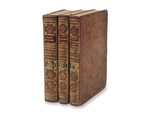
François Charles H. L. de Pouqueville Voyage en Morée, a Constantinople, en Albanie. 3 Bände. Paris, Gabon 1805. Erste Ausgabe des bedeutenden Werkes, mit großem Erfolg in Frankreich. Der französische Arzt Pouqueville wurde dafür zum französischen Konsul am Hof von Ali Pascha ernannt. 'Pouqueville wurde 1798 von mittelmeerischen Piraten nach Griechenland verschleppt, geriet dort in türkische Gefangenschaft und kehrte erst 1801 nach Frankreich zurück. Er berichtet über seine Erlebnisse und Beobachtungen in Griechenland sowie über Erlebnisse seiner Kameraden, die nach Albanien und Konstantinopel gebracht worden waren' (Griep/L.). 'The first and probably the best of all Pouqueville's books on Greece' (Blackmer). Einband: Gefleckte braune Lederbände der Zeit mit reicher Rückenvergoldung und 2 Leder-Rückenschildern. 19,5 : 13 cm. - ILLUSTRATION: Mit 3 (1 gefalteten) gestochenen Tafeln, 2 gestochenen Faltkarten und 1 Falttabelle. - KOLLATION: 3 Bll., VII, 542 S.; 2 Bll., XV, 287 S.; 2 Bll., XXI S., 1 Bl., 344 S. LITERATUR: Blackmer 1344. - Chahine 3838. - Griep/Luber 1105 Anm. First edition of probably the best of all Pouqueville's books on Greece. With 3 (1 folding) engr. plates, 2 engr. maps and 1 folding table. Contemp. mottled calf with rich gilt spine and 2 labels. - Partly waterstained (mostly at beginning and at the end), map of Moirée with small hole in the fold and marginal tear. Binding rubbed and slightly bumped, covers partially scraped. Dieses Objekt wird regel- oder differenzbesteuert angeboten.
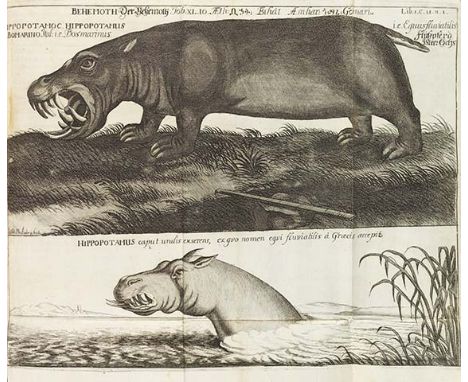
Hiob Ludolf Historia Aethiopica sive brevis & succincta descriptio regni Habessionorum, quod vulgo male Presbyteri Iohannis vocatur. Frankfurt, C. Wust für J. D. Zunner 1691. Erste Ausgabe der bedeutenden Landeskunde, welche die Äthiopistik als Disziplin begründete. Der deutsche Orientalist Hiob Ludolf (1624-1704) veröffentlichte auch die erste amharische Grammatik. Das vorliegende Werk basiert hauptsächlich auf jesuitischen Quellen sowie auf Informationen des äthiopischen Mönchs Abba Gregory, dessen Bekanntschaft Ludolf in Rom gemacht hatte. Bis 1694 erschienen noch 2 Supplemente. Die Tafeln zeigen Schafe, Affen, Nilpferde, Elefanten, Grabfries etc. Die Karte mit einer Gesamtansicht von Äthiopien. - Titel in Rot und Schwarz, Text tlw. zweispaltig in Latein und Amharisch gedruckt. Einband: Späterer geweißter Halblederband mit Rückenschild und -vergoldung. 29,5 : 19,5 cm. - ILLUSTRATION: Mit 8 gefalteten Kupfertafeln, 1 gefalteten Kupferkarte und 2 doppelblattgroßen Tabellen. - KOLLATION: 168 nn. Bll. - PROVENIENZ: Exlibris Waldemar Schwalbe. LITERATUR: VD 17, 23:230532H. - Ibrahim-Hilmy I, 395. - Gay 2658. - Cox I, 365 ('Still a valuable work'). - Tiele 702 Anm. First edition. With 8 folding copperplates, 1 engr. map and 2 charts. Later half calf with label and gilt decoration on spine. - Lacking as usual the engr. portrait. Partly slightly foxed and slightly browned in places, maps with 2 backed tears, 5 plates and last index leaf with backed marginal tears, title vo. stamped (withdrawn) and backed in the fore edge and with small defect to upper corner. - Bookplate Waldemar Schwalbe. Dieses Objekt wird regel- oder differenzbesteuert angeboten.

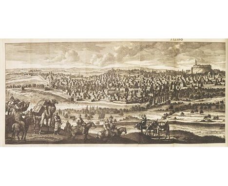
Cornelis de Bruyn Reizen door de vermaardste Deelen van Klein Asia, de Eylanden Scio, Rhodus, Cyprus .. mitsgaders de vornaamste Steden van Aegypten, Syrien en Palestina. Delft, H. van Krooneveld 1698. Erste Ausgabe von De Bruyns umfassender, reich illustrierter Reisebeschreibung in einem seltenen vollständigen Exemplar. 'His book is said to be one of the best illustrated works on the Levant.' (Cox I, 218) - Der niederländische Maler Cornelis de Bruyn (auch: de oder le Brun, 1652- um 1727) bereiste 1677 bis 1684 den Mittleren Osten, mit Abstechern in die Türkei, Griechenland, Ägytpen, Palästina, Syrien und Zypern; später ließ er sich in Venedig nieder, um 1693 in die Niederlande zurückzukehren. Die Bedeutung seiner Reisebeschreibung liegt vor allem in den Tafeln, deren Vorlagen De Bruyn meist selbst anfertigte und die u. a. von Jan und Caspar Luyken gestochen wurden. Neben der oft fehlenden Faltkarte des östlichen Mittelmeerraums zeigt das Werk vor allem Stadt- und Landschaftsansichten, darunter die schönen Faltpanoramen von Smyrna, Konstantinopel, Bosporus, Rhodos, Bethlehem, Jerusalem, Aleppo, Palmyra und Tyros, ferner Trachten, Münzen, Bräuche und naturwissenschaftliche Darstellungen. Einband: Pergamentband der Zeit mit handschriftlichem Rückentitel. 34 : 23 cm. - ILLUSTRATION: Mit gestochenem Frontispiz, gestochenem Porträt, gestochener Faltkarte und 101 Kupfertafeln (20 gefaltet, 24 doppelblattgroß) sowie 20 Textkupfern. - KOLLATION: 9 Bll., 398 S., 4 Bll. - PROVENIENZ: Exlibris Waldemar Schwalbe. LITERATUR: Röhricht I, 277f. - Gay 2101. - Tobler S. 114. - Ibrahim-Hilmy I, 100. - Tiele 207. - Howgego B177. - Nederl. Scheepvaart Mus. I, 257. - Blackmer 225 Anm. First edition of the travel account by De Bruyn (also De or Le Brun). With engr. frontispiece, engr. portrait, engr. folding map, 101 engr. plates (20 folding, 24 doublepage) partly by Jan and Caspar Luyken, as well as 20 text engravings. Contemp. vellum. - Somewhat tanned, the large folding panoramic views partly with creases to folds, 1 folding plate (obelisk) with small tear to fold, but overall well preserved. Front board somewhat warped, spine torn at the top. - Bookplate Waldemar Schwalbe. Dieses Objekt wird regel- oder differenzbesteuert angeboten.
Ludwig Salvator Wintertage auf Ithaka. Prag, H. Mercy Sohn 1905. Erste Ausgabe der schönen Publikation über die Insel des Odysseus, in kleiner Auflage auf kräftigem Papier gedruckt. Wie der Sommerteil eines der seltensten Werke Ludwig Salvators. Prachtvolle aufwendige Monographie der im ionischen Meer gelegenen Insel Ithaka, welche die egendenumwobene Heimat des Odysseus gewesen sein soll. Neben einer umfassenden Beschreibung der allgemeinen und speziellen Verhältnisse beinhaltet sie auch die bekannten Archäologischen Plaudereien und geschichtlichen Winke . Einband: Orig.-Pergamentband von Ferd. Bakala, Wien, mit etw. Rücken- und Deckelvergoldung sowie Kopfgoldschnitt. 38,5 : 29 cm. - ILLUSTRATION: Mit 14 heliogravierten Tafeln nach Original-Aufnahmen von A. Vives und 40 Holzstichen nach Federzeichnungen des Verfassers sowie 1 gefalteten und auf Leinen gezogenen farblithographierten Karte. - KOLLATION: X S., 1 Bl., 310 S., 4 Bll. LITERATUR: Nicht bei Blackmer. First edition, very rare. With 14 plates, 40 woodcuts and 1 folded col. lithogr. map. Orig. vellum by Ferd. Bakala, Wien, with slight gilt decoration and top edge gilt. - Partly slightly foxed, margins browned. Binding with few scratches, front cover with small tear at the gilt filet. Altogether fine copy. Dieses Objekt wird regel- oder differenzbesteuert angeboten.

Landkarten Sammlung von 45 Landkarten. Überwiegend kolorierte Kupferstiche, wenige Holzschnitte, Niederlande, Deutschland, Frankreich u. a. 16.-18. Jahrhundert. 33 : 39 cm bis 62 : 100 cm. Umfangreiche Sammlung mit Weltkarte, Karte der östlichen Hemisphäre, Kontinentkarten von Asien und Afrika, Mond- und Himmelskarte sowie Länderkarten von Europa und Teilkarten von Deutschland. Darunter: I: Das erst general inhaltend die beschreibung und den circkel des gantzen erdtreichs und moeres. Weltkarte in Oval. Holzschnitt von Daniel Kandel aus Sebastian Münster, Basel 1550ff. - Shirley 92. - Leicht fleckig, mit tlw. unschön geklebten Randeinrissen. - II: Asia wie es jetziger zeit nach den fürnemesten Herschafften .. Holzschnitt aus Sebastian Münster, Basel um 1580. - Gebräunt, Mittelfalte leicht leimschattig. - III: Indiae orientalis, nec non Insularum adiacentium nova descriptio. Kolor. Kupferstich bei Nicolaus Visscher, Amsterdam um 1680-90. - Leicht gebräunt. - IV: Asia accuratissime descripta. Kolor. Kupferstich nach Nicolai Witsen bei P. Schenk, Amsterdam um 1700. - Grünes Kolorit etw. oxidiert, in der linken Blatthälfte dadurch stellenw. mit kl. Papierbrüchen. - V: To the right Honourable William Lord Cowper .. this map of Asia. Großformatiger grenzkolor. Kupferstich bei Hermann Moll, London um 1710. - Formatbedingt mit kl. Randläsuren, Falzungen verstärkt. - VI: Hemisphère oriental. Grenzkolor. Kupferstich von G. Delisle bei Covens und Mortier, Amsterdam um 1730. - Etw. gebräunt, Mittelfalte leicht stockfleckig, Papierränder leicht knittrig. - VII: Tabula selenographica. Kolor. Kupferstich nach Joh. Doppelmayr bei J. B. Homann, Nürnberg 1742. - Leicht fleckig, Ränder mit kl. Einrissen und Knickspuren. - 38 weitere Karten und 1 Beigabe. Collection of 45 maps (mainly col. engravings, few woodcuts) from works published by mapmakers like Münster, Moll, Visscher, Delisle, Schenck, Doppelmayr. Netherlands, Germany et al. 16th to 18th century. - Partly stained and with small marginal tears or defects. - 1 addition. Dieses Objekt wird regel- oder differenzbesteuert angeboten.
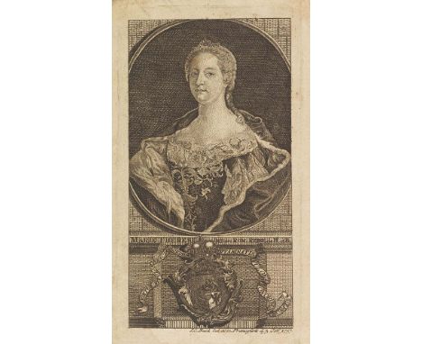
Jean Bertholet Histoire ecclésiastique et civile du Duché de Luxembourg et Comté de Chiny. 8 Bände. Luxemburg, A. Chevalier 1741-1743. Selten vollständig auffindbare Geschichte von Luxemburg mit der meist fehlenden Faltkarte von A. Wiltheim. Aus dem Besitz von Maria Theresia von Österreich. Erste Ausgabe. - Nicht nur umfangmäßig wichtigstes historisches Werk über das alte Herzogtum, so vollständig wie vorliegend immer noch selten und gesucht. Im ersten Band finden sich 4 Ansichten der Igeler Säule von P. A. Kilian, Band 6 mit Münzkupfern. Einband: Lederbände d. Zt. mit geprägtem Rückentitel. 26 : 19 cm. - ILLUSTRATION: Mit gestochenem Frontispiz, Porträtkupfer, 21 Kupfertafeln und 1 gefalteten Kupferkarte. - PROVENIENZ: Aus dem Besitz der Maria Theresia von Österreich, Habsburg und Böhmen (1717-1780) mit Ihrem Porträt-Exlibris (gestochen und datiert 3. Okt. 1757 von I. C. Back). - Besitzeintrag von W. L. von Preuschen (1806-1864), dat. 1822 LITERATUR: Van der Vekene D. 288. - De Backer/S. I, 1387. 8 vols. Rare complete history of Luxembourg with the mostly missing folding map by A. Wiltheim. From the possession of Maria Theresa of Austria. With engr. frontispiece, engr. portrait, 21 copperplates and 1 engr. folding map. Contemp. calf. - Partly browned and waterstained. Binding scraped and bumped, covers in places with traces of worming, 5 extremities of spine with larger defects. From the possession of Maria Theresa of Austria, Habsburg and Bohemia (1717-1780) with her portrait bookplate (dated October 3, 1757, by I. C. Back). - Ownership entry of W. L. von Preuschen (1806-1864), dated 1822. Dieses Objekt wird regel- oder differenzbesteuert angeboten.

Claudius Ptolemaeus Tabulae geographicae orbis terrarum veteribus cogniti. Utrecht, F. Halma u. a. und Franecker, L. Strick 1698. Schönes Exemplar der Ptolemaeischen Geographia nach Mercator. Zweite Ausgabe bei Halma, bis auf das Textblatt identisch mit der Erstausgabe 1695. - 'The plates of the Mercator maps were at the 1694 auction probably bought by François Halma (1632-1722) and used again for three editions in the years 1695-1704. The plates have been reworked. Modern cartouches with titles replace the old cartouche with the text concerning the meridian .. All maps are blank on verso. The sequence of the maps differs too.' (Van der Krogt I, 491) - Mit 28 Karten der alten Welt, darunter Weltkarte, Teilkarten von Europa, Nordafrika und Asien, mit figürlichen Schmuckkartuschen und etwas Staffage in Form von Segelschiffen, Seeungeheuern und Szenen mit einheimischen Völkern und Tieren. In sorgfältigem neueren Flächenkolorit im Stil der Zeit. Einband: Neuer Halblederband im Stil der Zeit. 44 : 29,5 cm. - ILLUSTRATION: Mit koloriertem allegorischen Kupfertitel und 28 kolorierten doppelblattgroßen Kupferkarten von G. Mercator nach C. Ptolemaeus. - KOLLATION: 1 Bl. Titel mit Tafelverzeichnis. - PROVENIENZ: Kupfertitel umseitig mit Bibliotheksstempel der 'Dr. Williams's Library Red Cross Street, London'. LITERATUR: Koeman Me 6. - Van der Krogt I, 1:522. - Phillips/Le Gear 526. Second edition by F. Halma (of 3). With col. engr. title and 28 col. doublepage engr. maps by G. Mercator after C. Ptolemy. Modern half calf in contemp. style. - All leaves set on new guards, overall only slightly stained, few maps slightly gluestained along the fold, ca. 5 maps with split to the bottom of fold (partly up to the platemark), 1 map with slight waterstaining in upper margin. - Engr. title on verso with stamp of the 'Dr. Williams's Library Red Cross Street, London'. Dieses Objekt wird regel- oder differenzbesteuert angeboten.

Abraham Ortelius Septentrionalium regionum descrip. Kolorierter Kupferstich von Frans Hogenberg aus Ortelius, Antwerpen 1587. 36 : 49 cm. Die schöne bekannte Karte des Nordmeeres, bei der es sich um die seinerzeit detaillierteste Darstellung des skandinavischen Raumes handelte. 'This map owes its cartography to a combination of Olaus Magnus' map of Scandinavia in 1539, and to the Nicolo Zeno map of 1558. A number of mythical islands appear in the North Atlantic; Drogeo , however, is believed to represent Newfoundland. The mainland of America is depicted in the north-west with the placename Estotilant .' (Burden) - In schönem Altkolorit und geschmückt mit Segelschiffen und Seeungeheuern. Mit französischem Rückentext. LITERATUR: Ort 160.4 (von 7) noch ohne den Zusatz 'Petzorka vulgo' zu 'Mare congealtum'. - Van der Krogt 1200:31. - Burden 40. 'When this map appeared it was probably the best one of the Scandinavian area so far' (Van den Broecke S. 478). - From the French edition 1587. - With small split to bottom of centrefold and very tiny wormhole to bottom left papermargin, otherwise clean copy in old coloring. Dieses Objekt wird regel- oder differenzbesteuert angeboten.

Anton Heimreich Ernewerte Nordfresische Chronick, darin die Beschreibung der dem Schleßwigischen Hertzogthum incorporirten Freschen Landschafften. Schleswig, J. Holwein 1668. Zweite Ausgabe der seltenen Chronik Nordfrieslands. Mit einer schönen Karte der nordfriesischen Inseln und Halligen. Erstmals 1666 erschienen und zugleich die erste in Druckform herausgegebene nordfriesische Chronik. - 'Aus dem Plan einer Beschreibung Nordstrands entstand H.s Hauptwerk, die Nordfriesische Chronik , in der er als erster ganz Nordfriesland im Zusammenhang behandelte .. Da er auch in der Gliederung und Darbietung des Stoffes nicht sehr gewandt war, liegt die Bedeutung seines Buches vor allem im Quellenwert des aus heute verlorenen Dokumenten geschöpften Materials und der Nachrichten aus H.s Zeit. Der 2. Ausgabe hat er zwei eigene Gedichte beigegeben, die zu den wenigen Zeugnissen des strandfriesischen Dialekts gehören.' (Klose/Rudolph) - Der gestochene Titel von M. Petersen u. a. mit Plänen von Tondern, Husum, Tönning, Bredstedt und Garding. Einband: Lederband der Zeit mit etw. Vergoldung. 20 : 16 cm. - ILLUSTRATION: Mit illustriertem Kupfertitel von M. Petersen, 1 gefalteten Kupferkarte und 1 gefalteten Stammtafel. - KOLLATION: 16 Bll., 410 S., 9 Bll. LITERATUR: Kat. Schleswig-H. II, 728. - Klose/Rudolph IV, 86. Second edition of the rare North Freesian chronicle. With engr. title, engr. folding map and 1 folding chart. Contemp. calf with some gilt decoration. - Slightly tanned. Front board nearly detached and waterstained, head of spine with defect. Dieses Objekt wird regel- oder differenzbesteuert angeboten.
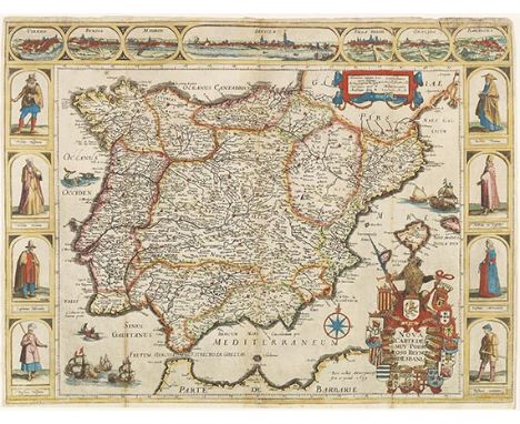
Pieter Verbiest Nova carte del muy podroso reyno d'Espania. Grenz- und flächenkolorierter Kupferstich von P. Verbiest, Amsterdam 1639. 42 : 55,5 cm. - Einblattdruck - Wie alle Arbeiten des Amsterdamer Kupferstechers und Verlegers Pieter Verbiest (um 1605-1693) sehr selten - Geschmückt mit 3 Bildleisten mit Stadtansichten und Kostümdarstellungen - Zweiter, bei Hollstein nur als Anmerkung erwähnter Druckzustand 'An untraced second state of the plate' (Hollstein) Schöne barocke Karte der Königreiche Spanien und Portugal, an drei Seiten von acht Kostümdarstellungen und sieben Stadtansichten (Toledo, Burgos, Madrid, Sevilla, Valladolid, Granada und Barcelona) eingerahmt. Das Kartenbild mit Grenzkolorit, die beiden Kartuschen (darunter die große Titelkartusche mit Wappen), die Trachtenfiguren, Städteansichten und das maritime Beiwerk koloriert. Hier im zweiten Druckzustand (von 3; erste Ausgabe datiert 1629, dritte Ausgabe 1649) mit dem Jahr 1639 in der Verlegeradresse und ohne eine vierte Leiste mit weiteren Stadtansichten im unteren Rand. - Von dem vermutlichen Brüderpaar Pieter und Isaak Verbiest aus Amsterdam ist lediglich eine Anzahl Einblattdrucke mit Karten der niederländischen Provinzen und weiterer einzelner europäischer Länder sowie zwei schöne Weltkarten bekannt (vgl. Shirley 338 Anm.), ferner ein kleiner Atlas Novus tabularum geographicarum Belgicae liber (1616). - ZUSTAND: Bis auf einen Rand von ca. 0,5 cm leicht unregelmäßig beschnitten, bzw. unterer Rand entlang der Einfassungslinie angesetzt, wie vom Verleger herausgegeben. Mit kl. restaurierten Randläsuren und - einrissen. Ursprünglich mehrfach parallel gefaltet, mit fachmännischen Restauirerungen in den Falzen bzw. der rechte Falz neu zusammengesetzt, dort mit nur leichtem Bild- und Textverlust z. B. in der Wappenkartusche. Punktuell auf Karton aufgelegt, unter Glas gerahmt, nicht geöffnet. - LITERATUR: Hollstein XXXV, 183 Anm. - Tooley, Mapmakers VI, 317. Single-sheet map and carte-à-figures of Spain and Portugal. Engraving with outline and surface color by little-known engraver, publisher and cartographer Pieter Verbiest. Very scarce second state (of 3) with date 1639 and 3 borders instead of 4 with costumes and town views. - Trimmed to a margin of ca. 0,5 cm, resp. remargined along the bottom of the sheet (as published), with small restored defects and tears to margin. With 3 vertical folds, all with skilfull restorations, the fold on the right joined with only little loss of matter. Laid down on cardboard in places, framed under glass (not opened). Dieses Objekt wird regel- oder differenzbesteuert angeboten.
Giovanni Botero Relaciones universales del mundo primera y segunda parte. 2 Teile in 1 Band. Valladolid, Diego Fernandez Erben 1603 (Teil II: Diego Fernandez 1599). - Geographische und politische Beschreibung der Welt, maßgeblich bis weit ins 17. Jahrhundert - So vollständig mit beiden Teilen und den fünf Faltkarten von Fernando de Solis von größter Seltenheit - Mit Weltkarte und Karten der vier Kontinente nach Abraham Ortelius 'This Spanish edition is rare' (Rubens Borba de Moraes) 'For more than a century considered the best geography in existence' (Borba de Moraes). - Zweiter Druck der ersten spanischen Ausgabe, der Erstdruck erschien 1600 (Teil II in beiden Ausgaben im Kolophon mit 1599 datiert). Wie dieser äußerst selten: seit nahezu 30 Jahren das erste vollständige Exemplar dieser Ausgabe auf dem internationalen Auktionsmarkt. - Mit den schönen, von Fernando (auch: Hernando) de Solis weitestgehend nach Ortelius gestalteten Faltkarten Tipus orbis terrarum (Shirley 242), Europae , Asiae nova descriptio , Africa und Americae sive novi orbis nova descriptio , tlw. datiert 1598. 'Accompanying this Spanish translation of Giovanni Botero's popular Relationi Universali were five newly engraved maps of the world and four continents. The book was a treatise on the political and geographical state of the world. The map of America is a curious mix of the two similar maps by Abraham Ortelius of 1570 and 1587. The engraver, Hernando de Solis, chose to use the earlier Ortelius version of 1570 with the peculiar bulge to the south-western coastline of South America .. This well-engraved map is rarely found in the book, which is itself scarce. The inscription on the map shows that it was made in the year 1598' (Burden 129). Einband: Lederband des 17. Jahrhunderts mit Rückenvergoldung und -schild. 28,5 : 20 cm. - ILLUSTRATION: Mit gestochener Titelvignette mit Wappen und 5 mehrfach gefalteten Kupferkarten. - KOLLATION: 4 nn., 24, 207 (recte 205) num. Bll., 1 w. Bl.; 110 num. Bll. - ZUSTAND: Gering fingerfleckig und vereinzelt wasserfleckig, Faltkarten stellenw. mit kleinen Falzlöchern und Knickspuren in den Rändern, die Kontinentkarten stellenw. mit fachmännisch hinterlegten Falzrissen, die Karten jedoch bis auf vereinzelte Flecken sauber und insgesamt gut erhalten, Titelblatt neu angefalzt, unten mit neu angerändertem schmalen Abschnitt und rechts oben mit mont. Buchhändlerschild des 19. Jhs. Einband beschabt, Kapitale mit kl. Wurmlöchern, unten dadurch mit schmaler Fehlstelle. - PROVENIENZ: Französische Privatsammlung. LITERATUR: Palau 3704. - Sabin 6809. - Borba de Moraes I, 114. - Alden/Landis 603/17. Second issue of the first Spanish edition which had been published in 1600 (the second part in both editions dated 1599). With engr. title vignette with coat of arms and 5 engr. folding maps by Hernando (or Fernando) de Solis after Abraham Ortelius, depicting the world and the four continents. 17th cent. binding with gilt decoration and label on spine. - Only slightly fingerstained and very occasionally waterstained, the folding maps partly with small holes to the folds and marginal creases, the four maps of the continents here and there with skilfully rebacked tears to folds and margins, all five maps overall clean and well-preserved, title page remargined at the bottom and reinserted, with mounted 19th cent. bookseller label. Binding scraped, extremities of spine with small wormholes, tail of spine with missing piece. - French private collection. Dieses Objekt wird regelbesteuert angeboten (R).
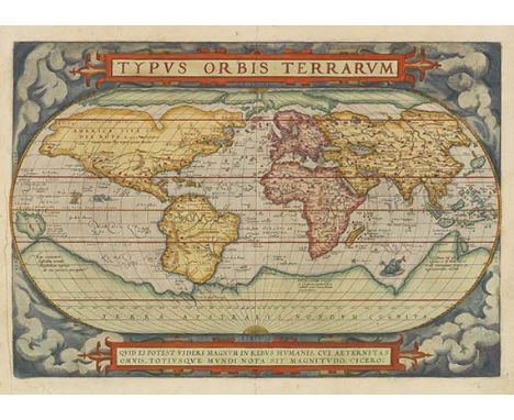
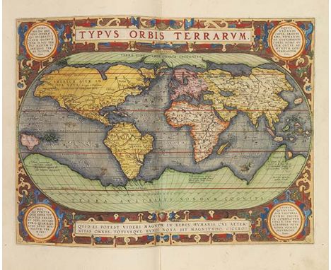
Abraham Ortelius Typus orbis terrarum. Kolorierter Kupferstich von Frans Hogenberg aus Ortelius, Antwerpen 1572-73. 33,6 : 49,2 cm. Frühe Ausgabe der ersten Fassung von Ortelius' schöner Weltkarte in Oval, gestochen von Frans Hogenberg. 'Ortelius' map was copied widely' (Shirley). - Dritter Druckzustand (von 6). Altkoloriertes Exemplar auf kräftigem Bütten. Mit deutschem Rückentext. - Ab etwa 1587 wurde diese Fassung wegen Beschädigung der Platte durch eine nahezu identisch gestochene Platte ersetzt, diese wurde dann jedoch bereits um 1592 durch eine vor allem hinsichtlich der Gestalt Südamerikas aktualisierte Version abgelöst. LITERATUR: Ort 1.3. - Van der Krogt 0001:31A. - Shirley 122. First version (of 3) of Ortelius' famous oval world map, in an early edition and with German text on verso. 3rd state (of 6). In contemporary colors and printed on strong laid paper. - Only slightly tanned and here and there stained, left white margin with printer's crease, centrefold with few smoothed creases. On verso with few paper remains. Dieses Objekt wird regel- oder differenzbesteuert angeboten.
Giovanni Battista Belzoni Narrative of the operations and recent discoveries within the pyramids, temples, tombs, and excavations, in Egypt and Nubia. Text und Atlas in 2 Bänden. - Angeb.: Ders. , Description of the Egyptian tomb. London, J. Murray 1821 (Text) und 1820 (Atlas). - Eine der größten bildlichen Aufzeichnungen der Ägyptologie des 19. Jahrhunderts - Tafelband in erster Ausgabe - Das erste englische Werk von Bedeutung mit Lithographien - Die Tafeln in gekonnter Farbgebung, teils wurden bis zu acht Farben auf einer Platte verwendet 'This was the first English work of any importance to use lithography' (Blackmer) Text in zweiter und Atlasband in erster Ausgabe. Die beigebundene kleine Beschreibung des ägyptischen Grabes in erster Ausgabe. Die vorliegende zweite Textausgabe enthält den Anhang von Thomas Young zu den Hieroglyphen (S. 485-533), der nicht immer in der ersten Ausgabe zu finden ist. Der italienische Abenteurer, Reisende und Archäologe Giovanni Battista Belzoni (1778-1823) trat zunächst im Zirkus auf und führte hydraulische Kunststücke vor. Durch Reisen lernte er den englischen Konsul H. Salt kennen, der ihn mit der Bergung ägyptischer Altertümer für das britische Museum beauftragte. Er 'unternahm bis 1819 vier größere Reisen durch Ägypten und Unter-Nubien, wodurch vor allem die Altertumskunde gewann .. aber auch die Geographie neues Licht erhielt' (Henze I, 239). Er bereiste Ägypten zwischen 1815-19, u. a. fand er die zweite Pyramide von Gizeh und öffnete das Grab von Seti I., zudem sandte er die riesige Büste von Ramses II. nach London. Belzoni zog vom Nil zum Roten Meer, wo ihm die Auffindung der Ruinen von Berenice glückte. Der Atlasband mit dem Titel Plates illustrative of the researches and operations in Egypt and Nubia enthält die 1-44 numerierten Tafeln und zeigen Ansichten sowie Details von Malereien etc. 'Belzoni is 'one of the most striking and interesting figures in the history of eastern travel' (DNB) and certainly, next to Burckhardt, the most interesting in the history of Egyptology and Egyptian travel' (Blackmer). Einband: Lederband d. 19. Jhs. mit goldgeprägtem Rückentitel, goldgeprägten ornamentalen Eckverzierungen, dreifachen Innenkantenfileten und Ganzgoldschnitt. 28 : 22 cm (Text) sowie Halblederband d. 19. Jhs. mit Rückenvergoldung und goldgeprägten Deckelfileten. 59 : 48 cm (Atlas). - ILLUSTRATION: Mit lithographiertem Frontispiz-Porträt, 1 lithographierten Tafel, 1 Schrifttafel und 2 lithographierten Karten auf 1 großen Falttafel (Textband) sowie 44 Ansichten und Plänen in Lithographie und Aquatinta auf 34 (30 kolorierten) Tafeln (Atlasband). - KOLLATION: VIII S., S. (V)-XI, S. (XI)-XIX, 533 S., 14 S.; 2 Bll. - PROVENIENZ: Gestochenes Wappen-Exlibris der Familie Carpenter mit dem Spruchband 'Per acuta belli'. - ZUSTAND: Ohne die überaus seltenen, später erschienenen 6 Supplementtafeln. - Textbd. stellenw. stockfl. (bes. zu Beginn), Karte des Nilflusses mit 2 kl. hinterl. Randeinrissen und kl. Knickspuren, Tafelbd. vereinz. fleckig, Textbll. mit restauriertem Randeinriß, Tafel 41 mit restauriertem Randeinriß (ohne Bildverlust). Kanten berieben, Rücken des Textbandes verfärbt. - LITERATUR: Blackmer 116-117. - Howgego II, B 28. - Abbey, Travel 268 (nur Atlas). - Gay 1940. - Ibrahim-Hilmy I, 62. - Vgl. Kainbacher 337 und Chahine 399 (frz. Ausg.). Text in second, atlas in first edition. With lithogr. frontispiece portrait, 1 lithogr. plate, 1 writing plate and 2 lithogr. maps on 1 large folding plate (text vol.) as well as 44 views and plans in lithography and aquatint on 34 (30 colored) plates (atlas vol.). 19th cent. calf with gilt title on spine, gilt ornamental corner decorations, triple inner edge fillets and gilt edges. 28 : 22 cm (text) and 19th cent. half calf with gilt spine and gilt fillets. 59 : 48 cm (atlas). - Without the extremely rare, later published 6 supplement plates. - Text vol. in places foxed (esp. at the beginning), map of the Nile river with 2 small restored tears and small crease marks, plate vol. stained in places, text leaves with restored marginal tear, plate 41 with restored marginal tear (without loss of image). Edges rubbed, spine of the text vol. discolored. Engraved coat of arms bookplate of the Carpenter family with the slogan 'Per acuta belli'. Bound with Belzoni's 'Description of the Egyptian tomb' (1821). Dieses Objekt wird regel- oder differenzbesteuert angeboten.

Willem Janszoon und Joan Blaeu Theatrum orbis terrarum, sive Atlas novus. Pars tertia. Amsterdam, Joan und Cornelius Blaeu 1640. Altkoloriertes Exemplar des Atlasbandes, der sich Italien, Griechenland und Großbritannien widmet. Band 3 der dreibändigen Ausgabe des Theatrum orbis terrarum mit lateinischem Text. In zeitgenössischem Grenzkolorit. - Enthält neben der Gesamtkarte von Italien weitere 55 Regionalkarten (von 57; fehlen die Karten von den Abruzzen sowie von Belluno und Feltre), ferner 4 Karten von Griechenland und der Ägäis sowie im separat betitelten Anhang Regnorum Angliae, Scotiae, et Hiberniae tabulas generales 4 Karten von Großbritannien, England, Schottland und Irland. Breitrandig, mit figürlichen Schmuckkartuschen, Wappen und maritimer Staffage ausgeschmückt. Einband: Goldgeprägter Orig.-Pergamentband mit Überstehkanten. 52 : 35 cm. - ILLUSTRATION: Mit illustriertem Kupfertitel mit montiertem Titelschild und 64 überwiegend doppelblattgroßen Kupferkarten mit Grenzkolorit (statt 66; 1 ganzseitig, 3 im Text). - KOLLATION: 67 num. Textbll., 2 nn. Bll. Register. - PROVENIENZ: Norddeutsche Privatsammlung. LITERATUR: Koeman Bl 36B. - Van der Krogt 2:201.3C. Volume 3 of the Theatrum orbis terrarum with Latin text, concerning mainly Italy and Greece, with a small appendix with 4 maps of Great Britain. Engraved architectural title with letterpress overslip and 64 engraved (of 66; 60 doublepage, 3 in text, 1 fullpage) maps with outline coloring. Publisher's vellum binding with gilt decoration on boards and spine. - Somewhat tanned, few maps stronger affected, upper corners with waterstain, few maps slightly foxed or with small waterstains, about 6 maps with crease parallel to centrefold, ca. 5 maps with small defects in lower margin, ca. 10 maps with split to lower centrefold (mostly only up to the platemark), 1 map with square loss of paper to lower right corner (the missing piece enclosed), pastedowns with tears. Binding stained, vellum cover of spine with defects. Overall still a nice copy. Dieses Objekt wird regel- oder differenzbesteuert angeboten.
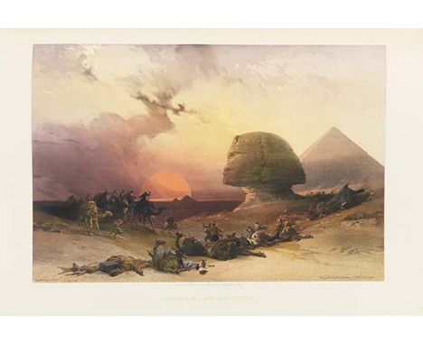
David Roberts Egypt and Nubia. From Drawings made on the spot. 3 in 2 Bänden. London, F. G. Moon 1846-1849. - Monumentales Prachtwerk des Orientmalers David Roberts - Mit künstlerisch herausragenden Ansichten von antiken Denkmälern und dem modernen Stadtleben in Ägypten und Nubien - Gutes breitrandiges und vollständiges Exemplar 'The apotheosis of the tinted lithograph' (J. R. Abbey) Erste Ausgabe, eines der monumentalsten und kostspieligsten Verlagsunternehmen des 19. Jahrhunderts. - Die historischen Beschreibungen stammen von William Brockedon, die Lithographien fertigte Louis Haghe nach Zeichnungen von Roberts. Sie zeigen u. a. die antiken Monumente von Philae, Abu Simbel, Gizeh, Luxor, Karnak, Theben sowie Stadtszenen von Alexandria und Kairo. Ein Großteil der der ganzseitigen Lithographien wurde von zweifach getönten Steinen gedruckt, die prominente Tafel Approach of the Simon sogar von einem dreifach getönten. - 'Roberts's Holy Land was one of the most important and elaborate ventures of nineteenth-century publishing, and it was the apotheosis of the tinted lithograph.. Haghe's skilful and delicate lithography, and his faithful interpretation of Roberts's draughtsmanship and dramatic sense, combine in what are undoubtedly remarkable examples of tinted lithographic work. Particularly in the Egypt and Nubia section one feels that the colossal subjects and broad vistas were ideally suited to Roberts's talent, trained as he was in theatrical scene-painting during his early days' (Abbey S. 341). Egypt and Nubia bildete ursprünglich die Fortsetzung von Roberts The Holy Land, das ab 1842 erschien. Letzte Hinweise darauf finden sich auf den Titelblättern, so wird Band 2 auf dem Titelblatt als Vol. 5 bezeichnet. Es wird aber als eigenständiges Werk angesehen und wird auch in der Literatur und den Bibliographien so beschrieben. Einband: Schwarze Halbmaroquin-Bände mit reicher Rückenvergoldung und Goldschnitt. 62,5 : 46 cm. - ILLUSTRATION: Mit 3 lithographierten Titeln mit Vignetten, 1 gestochenen Karte, 60 halbseitigen Lithographien und 61 ganzseitigen getönten lithographierten Tafeln von Louis Haghe nach David Roberts. - KOLLATION: Zu Beginn des 2. Bandes sind die beiden Titel zu Vol. II und III eingebunden, die Vol. II zugeordneten Tafeln sind jedoch auf beide Bände verteilt. Die sich jeweils halb- und ganzseitig abwechselnden Ansichten sind auf derselben bzw. gegenüberliegenden Seite erläutert, lediglich die Beschreibungen der drei Frontispize befinden sich am Ende des jeweiligen Tafelteils. Band I: Frontispiz, Titel (Vol. I), Widmung, 1 Bl. (Beschreibung der Titelvignette), 8 S. (Einleitung), 31 Bll. (beschreibender Text), 1 Bl. (Inhalt Vol. I+II). Band II: Frontispiz, Titel (Vol. II), 1 Bl. (Beschreibung der Titelvignette), Frontispiz, Titel (Vol. III), 29 Bll. (beschreibender Text), 1 Bl. (Beschreibung Frontispiz, verso Beschreibung von Titelvignette + Inhalt Vol. III). - ZUSTAND: Tlw. stockfleckig, Einbände etw. berieben. Insgesamt schönes, dekoratives Exemplar auf festem Papier, sehr breitrandig gedruckt (Papierformat 61,5 : 43 cm). - PROVENIENZ: Modernes Exlibris. - Skandinavische Privatsammlung. LITERATUR: Abbey Travel 272. - Ray 88. - Tooley 402. - Ibrahim-Hilmy II, 276. - Kainbacher I, 114. Fist edition of one of the most impressive and luxurious publishing projects of the 19th century. With text by William Brockedon and lithogr. illustrations by Louis Haghe after drawings by painter David Roberts (1796-1864): with 3 lithogr. title pages with vignette, 1 engr. map, 60 halfpage lithographs and 61 fullpage and tinted lithogr. plates, depicting famous views and monuments of Egypt. Black half morocco bindings with rich gilt decoration on spine and gilt edges. - Partly foxed. Bindings somewhat rubbed. Overall fine and decorative copy printed on strong paper with wide margins (size of the paper 61,5 : 43 cm). - Modern bookplate. - From a Scandinavian private collection. Dieses Objekt wird regel- oder differenzbesteuert angeboten.
Abraham Ortelius Theatrum orbis terrarum. - Parergon, sive veteris geograp(h)iae aliquot tabulae. - Nomenclator Ptolemaicus. - Zusammen 3 Teile in 1 Band. Antwerpen, Plantin für Jan Moretus 1601. - Überaus prachtvoll altkoloriertes Exemplar des berühmten Kartenwerkes - Ortelius setzte mit seinem ersten 'modernen' Atlas den Maßstab für alle nachfolgenden Atlanten - Vollständig mit den beiden Anhängen Parergon und Nomenclator sowie allen Karten - Ungewöhnlich sauber und wohlerhalten - In einem dekorativen Ledereinband der Zeit 'The unique position held by Ortelius' Theatrum in the history of cartography is to be attributed primarily to its qualification as 'the world's first regularly produced atlas' .. Shape and contents set the standards for later atlases' (Cornelis Koeman) Eines von nur 200 Exemplaren aus der letzten Ausgabe, die Jan Moretus in der Offizin Plantin für Ortelius' Erben drucken ließ. Später im Jahr 1601 verkauften diese die Kupferplatten und Verlagsrechte für das Theatrum an den Antwerpener Verleger Jan Baptist Vrients. - Vollständiges Exemplar mit 118 Karten im Theatrum ( numeriert 1-115 und mit den gegenüber der lateinischen Ausgabe 1595 ergänzten Karten 25*, 25** und 25***), sowie den 35 historischen Karten des Parergon . Darunter die Weltkarte in Oval, Kontinentkarten von Europa, Afrika, Asien und Amerika, Karte des Pazifik und des Nordmeeres, zahlreichen Teilkarten sowie den historischen Karten des Parergon. Mit Text in Latein. - Vermutlich eines der zuletzt gedruckten Exemplare dieser Ausgabe: das Titelblatt des Parergon hier nicht mehr mit der vorgesehenen Holzschnittbordüre, sondern vollständig in Kupfer gestochen wie eigentlich für die nächste lateinische Ausgabe 1603 bei J. B. Vrients (inkl. Schreibfehler 'Geograpiae', siehe Van der Krogt 31:2D.1), auch der Text auf dem Kupfertitel verso und auf den nachfolgenden Blättern a2r bis a4r wie in der Ausgabe 1603; der Drucksatz des Mottos auf a4v jedoch noch nicht komplett in Versalien, sondern wie in der Moretus-Ausgabe 1601 mit 'vetustas' und 'duximus' in Kleinbuchstaben. Einband: Lederband der Zeit (Verlagseinband?) mit verblaßter Goldprägung mit arabesken Eck- und großem Mittelstück mit Inschrift 'Theatrum orbis terrrarum', mit Schließbändern. 46 : 31 cm. - ILLUSTRATION: Mit 2 Kupfertiteln (1 koloriert), koloriertem gestochenen Porträt und zusammen 153 doppelblattgroßen Kupferkarten in Altkolorit. - KOLLATION: 6 Bll., 1 w. Bl., 4 Bll.; 1 w. Bl., 3 Bll., 1 w. Bl.; 1 w. Bl., 30 S., 3 Bll. - ZUSTAND: Das Porträt von Ortelius wohl aus einem anderen Exemplar der Ausgabe 1601 ergänzt (auf dünnerem Papier gedruckt und neu angefalzt, an den Seiten formatgerecht angerändert) und in den Blatträndern tlw. knittrig. Wenige Karten unten mit Einriß der Mittelfalte (die Karte " Ducatus mediolanensis" mit hinterlegtem längerem Einriß bis ins Kartenbild), sehr vereinz. mit kl. Randeinrissen, wenige Karten im breiten Rand vereinzelt minimal (finger-)fleckig, ansonsten ungewöhnlich sauberes, gepflegtes und wohlerhaltenes Exemplar. Einband mit fachmännischer Restaurierung der Kanten, des oberen und unteren Rückens und der Außengelenke. - PROVENIENZ: Kupfertitel Theatrum oben mit hs. Besitzvermerk des Baron Ferdinand Maria Franz von Neuhaus (1655-1716). Seit fast 40 Jahren in einer deutschen Privatsammlung. LITERATUR: Koeman Ort 33. - Van der Krogt 31:052. - Phillips/Le Gear 412. A beautiful and complete copy of the first 'modern' atlas by Ortelius. One of 200 copies from the last edition published by J. Moretus of the Plantin Press on behalf of the heirs of Ortelius. Complete copy with all three parts 'Theatrum', 'Parergon' and 'Nomenclator'; probably one of the last copies printed in this edition: the title page of the Parergon is engraved as in the first Latin edition 1603 by J. B. Vrients (to whom the plates and rights of the 'Theatrum' had been sold by the heirs later in the year 1601), but the setting of the text on verso and on the following 3 leaves suggests that the engr. title has not just been substituted from another copy of the 1603 edition. With col. engr. portrait, 2 (1 col.) engr. title pages and 153 doublepage engr. mapsheets, all in magnificent contemporary coloring. Contemporary (publisher’s?) calf with faded gilt decoration (central arabesque with inscription 'Theatrum orbis terrarum' and cornerpieces), with ties. - The engr. portrait of Ortelius probably substituted from another copy of the 1601 edition (printed on thinner paper, mounted on new fold and remargined to fit the size of the atlas) and partly creased in the margins. Few maps very slightly (finger-)stained in the wide margins, few maps with split to bottom of centrefold, only occasionally with small marginal tears (the map 'Ducatus mediolanensis' with rebacked tear into the illustration), otherwise an unusually clean and well-preserved copy. The binding with skilful restorations to edges, extremies of spine and outer hinges. Overall a remarkable copy of this famous atlas in beautiful contemporary colors. - Engr. title of the 'Theatrum' with manuscript ownership entry by baron Ferdinand Maria Franz von Neuhaus (1655-1716). In a German private collection for almost 40 years. Dieses Objekt wird regel- oder differenzbesteuert angeboten.

Joan Blaeu Grooten Atlas .. Tweede Stuck der Aerdrycks-Beschryving, 't welck vervat Duytsland en d'aengegrensde Landtschappen. Amsterdam 1664. - Vollständiges Exemplar des Deutschlandbandes - In schönem Flächen- und Grenzkolorit - Ungewöhnlich wohlerhalten und sauber - Im Verlagseinband Atlas von Deutschland, der Schweiz und Österreich sowie den angrenzenden Gebieten. Band II der niederländischen Ausgabe von Blaeus ehrgeizigstem Verlagsprojekt, dem Atlas maior , der je nach Ausgabe in 9 bis 12 Bänden erschien. Mit zwei Gesamtkarten von Deutschland, der schönen Karte der Herzogtümer Schleswig und Holstein mit 18 kleinen Stadtplänen im Rand von Johannes Mejer aus Caspar Danckwerths Regionalatlas Newe Landesbeschreibung , deren Kupferplatten Blaeu 1657 erworben und weitestgehend für seinen Atlas maior verwendet hat; weiterhin mit der Frankfurtkarte mit Wappenbordüre, sowie Karten von Böhmen und Mähren und den drei mehrfach gefalteten Karten vom Donaulauf, Rheinlauf und Elsaß. Zusätzlich eingebunden (gegenüber Koeman/Van der Krogt) die frühere der beiden Blaeuschen Holsteinkarten Ducatus Holsatiae nova tabula. S chönes breitrandiges und aufwendig koloriertes Exemplar. Einband: Lederband der Zeit mit Rücken- und Deckelvergoldung und goldgeprägtem Rückentitel (Verlagseinband). 55 : 37 cm. - ILLUSTRATION: Mit 108 Kupferkarten mit altem Flächen- und Grenzkolorit (st. 107; 107 doppelblattgroß, davon 3 zusätzlich mehrfach gefaltet; 1 blattgroß). - ZUSTAND: Die Karten schonend gereinigt und ingesamt wenig fleckig, neu angefalzt, mit wenigen Knickspuren parallel zur Mittelfalte und vereinz. Leimflecken, kleine Defekte und vereinz. Wurmspuren in den breiten Rändern fachmännisch restauriert oder hinterlegt, die im Querformat abweichenden Mejer-Karten von Holstein und Rendsburg an den Seiten etwas schmalrandig, das originale Altkolorit dezent und geschmackvoll überarbeitet, wenige Karten mit Farbabrieb (die zusätzlich eingebundene Holsteinkarte etwas stärker betroffen), die Karte der Herzogtümer Schlewig und Holstein im oberen Rand links mit längerem restauriertem Einriß (nicht bis in die Platte). Einband beschabt und mit Restaurierungen an den Kapitalen, Außengelenke gering eingerissen. Insgesamt ein schönes sauberes, breitrandiges und prachtvoll koloriertes Exemplar. - PROVENIENZ: Dänische Privatsammlung. LITERATUR: Van der Krogt 2:621.2. - Koeman Bl 57. Complete copy of the second volume covering Germany, Switzerland, Austria and adjoining countries. From the Dutch edition of the Atlas maior. With 108 (of 107, with 1 additional map of Holsatia by Blaeu) engraved maps (107 doublepage, 3 of which folding, 1 fullpage map), all in skilfully touched-up contemporary surface and outline coloring. Publisher's calf binding with gilt decoration and gilt title on spine. - Maps very carefully washed and inserted on recent guards, few maps therefore with creases parallel to the centrefold and with occasional gluestaining, but overall with only slight staining, some small marginal defects and few wormtraces all skilfully restored and rebacked, 2 maps from Mejer with narrow side margins due to the larger format of the plates, colors of few maps slightly worn in places (the additonal map of Holsatia somewhat stronger affected), the map of Schleswig and Holstein with restored tear to upper margin (not affecting the illustration). Binding scraped, with restorations to extremities of spine, outer joints with small tears. Overall a clean and well-preserved copy with wide margins and magnificent coloring, in a publisher's binding. - From a Danish private collection. Dieses Objekt wird regel- oder differenzbesteuert angeboten.
George Wheeler A journey into Greece. In company of Dr. Spon of Lyons. In six books. London, W. Cademan, R. Kettlewell, A. Churchill u. a. 1682. Erste Ausgabe der ersten systematischen und topographischen Beschreibung Griechenlands. Zugleich die erste altertumswissenschaftliche Expedition, von der sorgfältige Aufzeichnungen angefertigt wurden. Wheeler, der zusammen mit Jakob Spon in den Jahren 1675-76 reiste, war für die topographischen und botanischen Belange zuständig, während Spon sich der altertumskundlichen Erforschung widmete. - 'Wheeler's work remained the standard English book on Greece for many years, though curiously enough it has never been reprinted. It represents, together with Spon's book in French, the first attempt at a systematic topographical description based upon explorations' (Blackmer). Einband: Lederband unter Verwendung der zeitgenössischen Einbanddeckel und des alten Rückenschildes. Folio. 30 : 20 cm. - ILLUSTRATION: Mit 88 Textkupfern, 7 Kupfertafeln (4 ganzseitig) und 1 gestochenen Faltkarte sowie zahlreichen Textholzschnitten. - KOLLATION: Titel, 6 Bll., S. 1-80, 177-483 (Paginierungsfehler). - PROVENIENZ: Gest. Exlibris Walter Synnot Esq. (Sohn von Sir Walter Synnot; 1773-1851). - Exlibris H. & W. Uellner. LITERATUR: Blackmer 1786. - Cox I, 212. - Lowndes IV, 2888. - Vgl. Griep/Luber 1487 (frz. Ausgabe). Angebunden: Isaac Spon, The history of the city and state of Geneva. Mit Kupfertitel, 1 Textkupfer, 1 Textholzschnitt, 3 Kupfertafeln (2 gefaltet) und 1 Holzschnitt-Tafel. Ebd. 1687. 3 Bll., 250 S., 3 Bll. - Erste englische Ausgabe. - Frontispiz und 1 Tafel mit Gesamtansicht von Genf, ferner eine Umgebungskarte und Plan der alten Stadt. - Etw. fleckig, 2 Bll. mit ausgebessertem Randeinriß. - Cox I, 111. - Vgl. Lonchamp 2769 (frz. Ausgabe). I. First edition. With 1 folding engr. map, 7 (4 fullpage) copperplates, 88 engr. illustrations and numerous woodcuts in text. Calf using old covers and label on spine. - Somewhat browned and foxed, title with marginal fraying, 2 corners mended, 2 leaves with restored tears. Map trimmed and backed, also with restored defective spot. Covers partly scraped. - II.First edition. With engr. frontispiece, 1 woodcut and 1 engraving in text, 3 (2 folding) copperplates and 1 woodcut plate. - Somewhat spotted, 2 leaves with mended tear. Dieses Objekt wird regel- oder differenzbesteuert angeboten.
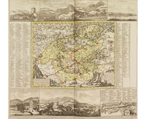
Peter Schenk Neuer Sächsischer Atlas, enthaltend die sieben Kreise des Kuhrfürstenthums Sachsen .. nebst allen angrenzenden Landen und den Fürstenthümern und Herrschaften des Fürstlichen Hauses Sachsen. Amsterdam und Leipzig, P. Schenk 1753 (Karten datiert 1746-1758). - Spezialatlas des Kurfürstentums Sachsen - Ungewöhnlich sauberes Exemplar in schönem Altkolorit - In einem dekorativen zeitgenössischen Ledereinband 'Some of the maps are elaborate in their illustrations' (Cornelis Koeman) Seit 1752 von P. Schenk junior in unterschiedlicher Zusammenstellung herausgegebener Regionalatlas, dessen Karten auf den handgezeichneten Ämterkarten von A. F. Zürner basieren. 'The great activity in map publishing, displayed by Petrus Schenk, the elder, was continued by his son and grandson' (Koeman III, 110). - Nahezu vollständiges Exemplar mit zusätzlichen Karten: Laut Koeman Sche 17 erschienen insgesamt 48 Karten in 56 Blatt; in vorlieg. Exemplar fehlen das zweite Blatt vom Ertzgebürgischen Creyss (18b), die Karten der Ämter Freyberg (22), Schwarzenberg (23) und der Herrschaft Töplitz (48) sowie das vierte Blatt vom Markgraftum Niederlausitz (38d), dafür sind die Karten des Amtes Bitterfeld (6) und des Kreisamtes Leipzig (13) zusätzlich in einer früheren Ausgabe eingebunden, ferner eine Wegekarte von Sachsen mit den Postrouten. Einband: Kalblederband der Zeit mit reicher ornamentaler Rückenvergoldung, goldgeprägtem Deckeltitel Cartes de l'Electorat de Saxe et pais voisins sowie goldgeprägter Bordüre. 54 : 34,5 cm. - ILLUSTRATION: Mit 51 Kupfertafeln (von 56) und zusätzlich 3 Kupferkarten, sämtlich in Grenz- und Flächenkolorit. - KOLLATION: 1 Bl. Drucktitel. - ZUSTAND: Karten vereinzelt mit schwachem Abklatsch, das grüne Kolorit gering oxidiert, ansonsten ungewöhnlich sauberes, innen wohlerhaltenes Exemplar in schönem Altkolorit. Einband leicht berieben mit einzelnen Flecken, Kanten und Ecken etw. beschabt, unteres Kapital mit Fehlstelle. - LITERATUR: Koeman Sche 13. - Phillips/Le Gear 3044. - LGK II, 704. Nearly complete, enriched copy of Schenk's regional Atlas of Saxony. With 51 (of 56 leaves) with col. engr. maps plus 3 extra maps. Contemp. calf with rich ornamental gilt decoration on spine, gilt title in French and gilt border on front board. - Maps occasionally with slight offset, green coloring only slightly oxidized, otherwise unusually clean and inside well-preserved copy. Binding slightly scraped and with few staines, edges and corners somewhat rubbed, tail of spine with defect. Dieses Objekt wird regelbesteuert angeboten (R).
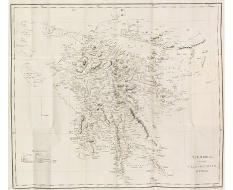
William Martin Leake Travels in the Morea. 3 Bände. London, J. Murray 1830. Erste Ausgabe der Reisebeschreibungen von Griechenland aus den Jahren 1805-1806. Einband: Geprägte Leinenbände d. Zt. 22,5 : 14,5 cm. - ILLUSTRATION: Mit 13 lithographierten Tafeln (2 gefaltet), 15 gestochenen Karten und Plänen (5 gefaltet) sowie großer gestochener Faltkarte von Griechenland. - KOLLATION: (III)-XVII S., 1 Bl., 513 S.; VII, 524 S., 1 Bl.; VII, 476 S. - PROVENIENZ: Besitzeintrag Sir Francis Edward Scott (1824-1863). - Gest. Wappenexlibris des Earl of Cromer, Evelyn Baring (1841-1917). - Exlibris H. & W. Uellner. LITERATUR: Blackmer 974. First edition. With large folding engraved map of Greece, 16 engraved regional maps and plans (5 folding), 12 lithographed plates of inscriptions (2 folding). Contemp. blindstamped cloth (spine renewed using old material). - Without the later published supplement volume, vol. I without half title. - Large folding map with small tear in the fold. The covers rubbed and somewhat stained, the spine renewed using old material. Inside clean, hardly stained copy. - Owner's entry of Sir Francis Edward Scott (1824-1863). - Engr. coat of arms of the Earl of Cromer, Evelyn Baring (1841-1917). - Bookplates H. & W. Uellner. Dieses Objekt wird regel- oder differenzbesteuert angeboten.
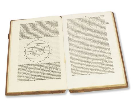
Aurelius Theodosius Macrobius In somnium Scipionis expositio. Saturnalia. 2 Teile in 1 Band. Venedig, Philippus Pincius, 29. Okt. 1500. - Bedeutendes Werk des Neuplatonikers Macrobius - Spielte im Mittelalter bei der Vermittlung antiken Bildungsguts eine wichtige Rolle - Berühmt für die darin enthaltene Weltkarte 'One of the leading popularizers of science in the Latin West' (DSB) Macrobius (um 385 bis nach 430) erläutert an ausgewählten Abschnitten von Ciceros Erzählung Somnium Scipionis (Scipios Traum) die neuplatonische Seelenlehre, Astronomie (mit Hinweisen auf den Planetencharakter von Mars und Venus, vgl. Stillwell 74) und Musiktheorie. 'Macrobius' lengthy excurses on Pythagorean number lore, cosmography, world geography, and the harmony of the spheres established him as one of the leading popularizers of science in the Latin West. Macrobius and Martianus Capella were largely responsible for preserving Crates of Mallos' theory of an equatorial and meridional ocean dividing the earth into four quarters, each of which was assumed to be inhabited' (DSB IX, 1). Sechste und letzte Inkunabelausgabe, erstmals 1472 in Venedig erschienen, hier eines der Exemplare mit der Druckvariante 'theodosii' (Bl. 3v, Z. 25). - Die enthaltene Weltkarte (Bl. 30r) wurde erstmals Brescia 1483 gedruckt. Es existieren vier Varianten, vorliegend die letzte. - Schöner Antiqua-Druck mit griechischen Einsprengseln. Einband: Zeitgenössischer Halblederband über Holzdeckeln mit Streicheisenlinien. Folio. 32 : 20,5 cm. - ILLUSTRATION: Mit großer schwarzgrundiger Holzschnitt-Initiale, halbseitiger Holzschnitt-Weltkarte und 7 schematischen Textholzschnitten. - KOLLATION: 36 (das erste weiß), 86 röm. num. Bll. (= 122 Bll.). Rom. Type. 45 Zeilen. - ZUSTAND: Vereinz. mit kl. Wasser- oder Braunflecken am Rand, letzte Bll. mit leichten Feuchtigkeitsspuren im Fußsteg, vereinz. wenige Wurmlöcher, Vorsätze mit einigen Wurmspuren. Hint. Deckel fleckig, Rücken tls. beschädigt, bewegl. Schließenteile entfernt. Das erste und letzte Bl. der Lage e (mit Weltkarte) auf dünnerem Papier und gebräunt, wie die Exemplare der BSB und des Brit. Museums. Innen sonst gutes und sauberes Exemplar in einem zeitgenöss. Holzdeckelband. - LITERATUR: Hain/Cop. 10430. - GW M19705. - Goff M 13. - BMC V, 499. - BSB M-5. - Essling 1232. - Klebs 638.5. - Zur Karte: Shirley 13, Block 4. Important work by the Neoplatonist Macrobius, played an important role in the Middle Ages in the teaching of ancient science. Famous for the world map it contains. 2 parts in 1 vol. With white-on-black woodcut initial, halfpage world map and 7 woodcut diagrams. Contemp. half calf over wooden boards. - The leaf with the map printed on thinner paper and browned like the copies in BSB and BMC. Here and there small water- or brownstains at margin, last leaves with slight traces by damp in lower margin, few wormholes here and there, endpapers with some worming, rear board stained, spine partly damaged. Else inside well-preserved copy in an unsophisticated contemp. binding over wooden boards. Dieses Objekt wird regelbesteuert angeboten (R).

Vincenzo Maria Coronelli Memorie istoriogeografiche della Morea riacquistata dall' Armi Venete del Regno di Negroponte. Venedig, Libraria della Verita für G. M. Ruinetti 1687. Seltene italienische Folio-Ausgabe. Behandelt Südgriechenland und zeigt viele der Schauplätze des Morea-Krieges auf, der Teil des größeren Konflikts im Großen Türkenkrieg zwischen der Republik Venedig und dem Osmanischen Reich war. Zweite erweiterte Folio-Ausgabe, die erste Folio-Ausgabe erschien ein Jahr zuvor. Um Text und Tafeln erweitert, die die neuen venezianischen Eroberungen seit der Veröffentlichung von 1686 beschreiben. Mit Ansichten, Karten und Plänen der damaligen Hauptorte auf dem südlichen Balkan und in Griechenland. Die Zusammenstellung und Anzahl der Tafeln schwankt, wie bei Coronelli üblich. Unser Exemplar entspricht genau dem der Blackmer Collection. „The plates in any work by Coronelli present a problem, as he added and subtracted or changed plates as he saw fit; he also used the same series of plates in different combinations which he dedicated to various important political figures in Venice. Plates which in our work appear as vignettes in the letterpress occur in a special edition/issue in the Marcian Library as separate plates .. The only plates which may be missing in our copy are two small views of Megara and Negroponte on a single leaf. The text on these places is present, and this plate appears in the Marcian Library copy, but it is not listed in the Catalogo de disegni .. However, nos. 17, 20 and 22 are also not on this list“ (Blackmer). Einband: Zeitgenössischer Pappband. 40,5 : 26 cm. - ILLUSTRATION: Mit gest. Titel, 22 Textkupfern und 41 Kupfern auf 29 Tafeln (davon 17 doppelblattgroß, 1 gefaltet) sowie 1 gefalteten Kupferkarte. - KOLLATION: 65 Textbll. (unregelmäßig foliiert, siehe unten). - PROVENIENZ: Exlibris H. &. W. Uellner. LITERATUR: Blackmer 408. - Vgl. Chahine 1105 (frz. Ausg.) und Phillips/Le Gear 8899f. Second enlarged folio edition. With engr. title, 22 engr. vignettes and 41 engravings on 29 plates (17 doublepage, 1 folding) and 1 folding engr. map. Contemp. card board. - With irregular stamped numbering of the sheets and plates, probably by the publisher, as a comparison with other copies suggests. - Few leaves slightly soiled, folding map from 2 leaves assembled (somewhat glue-shaded and with repaired defect at the margin), 1 text sheet with small pasted text passage, 2 leaves with backed marginal tear, inner book slightly broken. Binding slightly rubbed and soiled. Overall nice, clean copy. Dieses Objekt wird regel- oder differenzbesteuert angeboten.
Corneille Le Bruyn Voyage au Levant, c'est à-dire, dans les principaux endroits de l'Asie mineure. Paris, G. Cavelier 1714. - Eines der am besten illustriertesten Werke zu den Ländern am östlichen Mittelmeer - Die Vorlagen zu den hervorragenden Tafeln fertigte Le Bruyn meist selbst an 'His book is said to be one of the best illustrated works on the Levant' (Cox) Zweite französische Ausgabe; die holländische Originalausgabe erschien 1698 in Delft. Die Bedeutung der Reisebeschreibung liegt vor allem in den Tafeln, deren Vorlagen Le Bruyn meist selbst anfertigte. Sein Schwerpunkt lag dabei auf Stadt- und Landschaftsansichten, ferner lieferte er von den Ruinen der Persepolis die ersten lesbaren Keilschrifttexte. Wichtig auch die Darstellung einheimischer Trachten und der Tier- und Pflanzenwelt. 'The very interesting plates in this work are almost all after designs by de Bruyn, who specialized in landscapes and interiours. Most of the plates are views including large panoramic scenes of Constantinople, Smyrna, Alexandria, and Jerusalem. The costume plates are of particular interest since Bruyn has concentrated almost entirely on Greek and Turkish female head-dresses' (Blackmer). Ferner mit Ansichten von Chios, Rhodos, Tyros, Rama, Bethlehem, Aleppo usw. - Die Abb. sind numeriert 1-210, 1 und 2 auf S. 293, 170 doppelt, ferner A, A und B, 22 A-C, 125 A-B sowie 2 nicht numerierte kl. Abbildungen. Einband: Zeitgenössischer Kalblederband mit reicher Rückenvergoldung. 33,5 : 21,5 cm. - ILLUSTRATION: Mit gestochenem Frontispiz, gestochenem Porträt, 219 gestochenen Illustrationen im Text und auf 97 Tafeln (tlw. doppelblattgr. bzw. mehrfach gefaltetet) und 1 gefalteten Kupferkarte. - KOLLATION: 6 Bll., 408 S., 3 Bll. - ZUSTAND: Kaum gebräunt, die Karte im Kopfsteg knapp beschnitten,1 gefalt. Taf. mit Randeinriß. Einbd. mit Kratzspuren, Gelenke ausgebessert. - LITERATUR: Blackmer 225. - Chahine 2706. - Ibrahim-Hilmy I, 102. - Gay 2101. - Tobler S. 114. - Vgl. Lipperheide Ci 48f. Second French edition. With engr. frontispiece, engr. portrait, engr. folding general map and 219 engr. illustrations on 97 plates and in text. Contemp. calf with richly gilt spine. - Faintly browned, map cropped close at the top margin, 1 folding plate with marginal tear. Binding with scratches, joints mended. Dieses Objekt wird regel- oder differenzbesteuert angeboten.


A late 18thc/19thc map of Prospect of Leith from the East, dedicated to the Right Honorable Sir James Fleming Lord Provost of ye City of Edinburgh and ye rest of ye honorable council of the said Borough, the map humbly dedicated by Captain Greenvile Collins hydrographer to the King, in gilt glazed frame (folded: 46cm x 59cm) (slight spotting throughout)


A Collection of Sandwich Town and Church Guides, - including - C.P. Neilson (Ed) - "The Ancient Town and Port of Sandwich. Official Handbook, Illustrated", published by The Corporation of Sandwich, 1927, "Sandwich Parish Church (St. Clement), Founded 1060", W.J. Gordon - "Sandwich and Roundabout", printed by the Botolph Printing Works, London, and "A Street Map of Sandwich with Street Index and General Information. Presented with the Compliments of John Hogbin & Son, Auctioneers, Valuers and Estate Agents" and others (21)

Edward Hasted - "The History and Topographical Survey of the County of Kent", printed by Simmons & Kirkby, Canterbury, 1778-1799 (four gilt tooled leather bound volumes)Condition Report - Volume 1 - 8 maps, 21 plates - this does not include the large map of KentVolume 2 - 12 maps, 11 platesVolume 3 - 13 maps, 11 platesVolume 4 - 4 maps, 16 plates.This count excludes the smaller plates found throughout the printed text. Condition of volumes - volume 4 with detached front and back boards. Some bumping to corners and typical wear to spines and boards. All paintings appear to be present. No obvious damage/loss save for some discolouration/spotting to pages.

1971 Saab 96 V4 Transmission: manualMileage:61323The Saab 96 was manufactured and marketed from 1960 to January 1980, replacing the 93. The 96 featured aerodynamic two-door bodywork, four passenger seating and at first a two-stroke, three cylinder engine, later a four-stroke V4. The front end was lengthened for 1965 models, in preparation for a new engine, and the radiator was placed ahead of the engine rather than above and behind, a leftover from the thermosiphon cooling days. Both front and rear windows were enlarged slightly for 1968 models. The Saab 96 was driven most famously by Erik Carlsson in many international rallies, coming first in the 1960, 1961 and 1962 RAC Rallies and first in the 1962 and 1963 Monte Carlo Rallies. It was these successive, top-level victories that put the Saab 96 'on the map' and established its reputation for reliability and toughness. Carlsson also competed in the East African Safari Rally. Famous rallying names such as Simo Lampinen, Per Eklund, Pat Moss-Carlsson, Tom Trana, Stig Blomqvist and Carl Orrenius have also been connected with the Saab 96.This delightful Saab 96, first registered on 1st July 1971, is presented in red with retrimmed red and black vinyl seats and boasts a modern stereo. Owned and maintained by our enthusiastic vendor, this is a great entry level classic combining rally connotations from the great 96’s driven by Carlsson and Blomqvist with the practicality of four generous seats and a truly unique design. This long nose V4 version with the 1.5 litre 65 bhp engine is a slice of a bygone era and indeed manufacturer, as Saab ceased production altogether in 2014.Guide Price £3,000 - £6,000 Interested parties should satisfy themselves as to the description and condition of each lot prior to the sale. Accordingly, buyers are on notice that each vehicle is offered ‘as is/as seen’ subject to the Terms and Conditions for the auction. Buyers are advised to inspect the vehicle in person or use a professional to carry out this service. Historics will not entertain disputes over descriptions.

2020 Ford GT40 Mk. I Evocation by Southern GT Transmission: manualMileage:188The Ford GT40 is synonymous with Le Mans but was first seen at the Nürburgring in May 1964. The Mk. I was the original Ford GT40 but met little success in its initial tune for the 1964 and 1965 Le Mans races. The first success came after their demise at the Nassau Speed Weekend in November 1964 when the racing was handed over to Carrol Shelby. Shelby's team modified the Ford GT40 and the first win at Daytona February 1965 was achieved. 31 Mk. I examples were built at the Slough factory in ‘road’ trim, which differed little from the race versions. Wire wheels, carpet, ruched fabric map pockets in the doors and a cigarette lighter made up most of the changes.Registered new on 1st December 2020, this Superb Mk. I Southern GT has been meticulously constructed in recent years and has covered less than 500 miles since the build. Finished in the classic GT40 livery of Midnight Blue coachwork with white stripes, this example looks superb! The interior too is very well presented and includes Luke five-point harness seatbelts, Smiths Instruments, a 12 Volt socket, air conditioning, immobiliser, and a heated windscreen. Also installed is the correct Mk. I GT40 style right hand gear change and detachable steering wheel. The chassis was professionally powder coated and fitted with a Ford 302 V8 engine stroked to 347 which is mated to a UN1 five-speed manual gearbox. AP Racing brake discs and calipers are fitted all round and are coupled with three spoke knock off spinner alloy wheels.Our vendor reports that the GT40 is exceptionally fast and sounds fantastic when on song. The sizeable history file that accompanies this car includes all invoices from the build, many sundry bills, a spare key and the UK V5 registration document. Fitted with two uprated fuel tanks and new Avon tyres all-round, the GT40 is ready to be enjoyed by its new custodian. Not all GT40 replicas are created equally, this is an outstanding example both mechanically and cosmetically. Built to a very high standard, it is a faithful and accurate recreation that allows for track day and road use.Interested parties should satisfy themselves as to the description and condition of each lot prior to the sale. Accordingly, buyers are on notice that each vehicle is offered ‘as is/as seen’ subject to the Terms and Conditions for the auction. Buyers are advised to inspect the vehicle in person or use a professional to carry out this service. Historics will not entertain disputes over descriptions.


-
108737 item(s)/page