We found 108737 price guide item(s) matching your search
There are 108737 lots that match your search criteria. Subscribe now to get instant access to the full price guide service.
Click here to subscribe- List
- Grid
-
108737 item(s)/page


Lot 111
A George III silkwork map sampler, embroidered with England and Wales, showing their respective counties and surrounding named bodies of water, the lower right with the north-west French coast, within a border of poppies, roses and further English flowers, monogrammed and dated 1817, oval, 58cm x 51cm
![Ordnance Survey of Ireland: Geological Survey of Ireland, Cushendall [County Antrim], Sheet 14, Engraved at the Ordnance Surv](https://cdn.globalauctionplatform.com/e71b8453-d5a5-4911-8785-a7ac010039d3/7029f244-9707-40a5-85d9-150764d882c6/468x382.jpg)
Lot 159
Ordnance Survey of Ireland: Geological Survey of Ireland, Cushendall [County Antrim], Sheet 14, Engraved at the Ordnance Survey Office, Dublin under the direction of Captain Wilkinson R.E., The Outline by Robert Mahony, the Writing by James Aikman, the Hills by John Duncan, Published by Colonel Sir H. James R.E., F.R.S., M.R.I.A. &c., Superintendent of the Ordnance Survey [...] 1886, four-fold map, hand-coloured engraving, 36cm x 54cm
![[Guthrie (William)], The Auftrian (sic), French and Dutch Netherlands, from the beft (sic) Authorities, Published by C: Dilly](https://cdn.globalauctionplatform.com/e71b8453-d5a5-4911-8785-a7ac010039d3/ad6e7404-ef54-4707-aa6b-2fea18acc7f9/468x382.jpg)
Lot 158
Ordnance Survey of England and Wales: Geological Survey of England and Wales, Sheet 92 N.E. (New Series Sheet 61) [part, North Yorkshire Moors], Engraved at the Ordnance Survey Office Southampton, The Outline by J. Adkins, the Writing by J.A. Harrison, The Hills by H. Dixon, Published by Colonel James R.E., F.R.S., M.R.I.A. &c., Superintendent [..] 1889, map, hand-coloured engraving, 37cm x 57cm
![Militaria - a WW2 ink MS and watercolour two-fold map, 144 Brigades Positions, Feb: 1940, Saar Front [Germany], 39cm x 26cm](https://cdn.globalauctionplatform.com/e71b8453-d5a5-4911-8785-a7ac010039d3/edeb6338-7ab5-4a05-b5ce-a15a99272033/468x382.jpg)
Lot 173
Militaria - a WW2 ink MS and watercolour two-fold map, 144 Brigades Positions, Feb: 1940, Saar Front [Germany], 39cm x 26cm Condition Report: Please see additional photographs, generally good condition, a couple of tears, creases and some foxing but clear and legible, appears to be just paper, no apparent backing, would be best to leave a commission bid or register online to bid, telephone lines are not available on this lot


Lot 51
Mauchline ware _ sewing _ seven pieces, comprising a wool bowl (Hexham Abbey and Shambles) 8.5cm dia, a thimble sauce pan (Stirling Castle, From Back Walk/Bought In The Douglas Roomƒ/Ye Towersƒ), 9cm, a darning mushroom (The Ancient Entrance Gate, Stirling Castle), 10cm, a cylinder box form pincushion (Peterborough Cathedral) 6.5cm, a needlebook (Thurso Castle From South), 9x6cm, a knitting needle cylinder (The Tower of London From Tower Hill/Manufactured abroad) 22cm, and a calendar and map paper knife 1898 (Eastern Telegraph Company), 34cm (7)

Lot 486
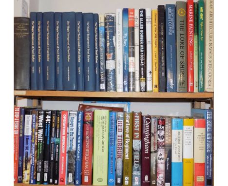
Maurice (Frederick). History of the War in South Africa, 1899-1902, volumes 1-4, plus 4 volumes of maps to volumes 1-4, 1906-10, numerous black and white maps, some light marks, uniform original gilt decorated blue cloth, boards and spines lightly rubbed, 8vo, together with Ewing (John), The Royal Scots 1914-1919, volume 1 only, 1st edition, 1925, numerous black and white illustrations, including folding map to rear, some minor toning, original blue cloth, boards lightly marked, 8vo, and other early 20th century and modern military reference and related, including publications by Airlife, Arms & Armour, P.S.L., Pen & Sword, mostly original cloth, many in dust jackets, some odd volumes, G/VG, 8vo/folio (6 shelves & a carton)

Lot 177
*World. Berry (William), A Mapp of all the World in two Hemispheres in which are exactly described all the parts of the Earth and Seas, Described by Sanson, Corrected and amended by William Berry, 1680, engraved map with contemporary hand colouring, some creasing, some dust soiling, repaired closed tears, torn with areas of loss and replaced in facsimile, 545 x 865 mm, mounted, framed and glazed R.W.Shirley. The Mapping of the World, no.501. Not examined out of frame. (1)
Lot 776
Betjeman (John). New Bats in Old Belfries, 1945; A Few Late Chrysanthemums, 1954; A Nip in the Air, 1974, 1st editions, original cloth, New Bats spine darkened, dust jackets, A Nip in the Air price-clipped, New Bats spine toned with small chips at ends, 8vo, together with Murray's Buckinghamshire Architectural Guide, 1st edition, 1948, folding map and half-tone illustrations, original cloth, price-clipped dust jacket, a couple of small closed tears and nicks, 4to, signed to title by John Betjeman, with five others including Church Poems, 1980 (the withdrawn first issue with the 'Bristol and Clifton' poem incomplete), and A Garland for the Laureate. Poems Presented to Sir John Betjeman on his 75th Birthday, Celandine Press, 1981, limited edition 83/350 (9)

Lot 47
Roger (Eugene). La Terre Saincte; ou Description Topographique tres-particuliere des saincts Lieux, & de la Terre de Promission. Avec un Traitté de quatorze nations de differente Religion qui l'habitent, leurs murs, croyance, ceremonies, & police. Un Discours des principaux poincts de l'Alcoran. L'histoire de la vie et mort de l'Emir Fechrreddin, prince des Drus. Et une Relation veritable de Zaga Christ Prince d'Ethyopie, qui mourut à Ruel prez Paris l'an 1638..., 1st edition, Paris: Antoine Bertier, 1646, folding engraved map of Palestine and thirty-six engraved illustrations to text (including 20 full-page illustrations of costume), old german blindstamps to few leaves, occasional scattered spotting, some dampstaining mostly to first few leaves, contemporary vellum, 4to Blackmer 1443; Atabey 1051; Tobler, p.100; Rouillard, p.255; Goldsmith R951. "Roger spent five years in Palestine. His work consists for the most part of a discussion of the 14 'nations' inhabiting the Holy Land together with a vituperative account of Islam. Rouillard gives 1644 as the date of the first edition but according to the privilege the work was first printed in 1646." (Blackmer). The source of the interesting plates is unknown. (1)
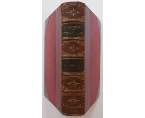
Lot 18
Du Chaillu (Paul B.). A Journey to Ashango-Land: and further penetration into Equatorial Africa, 1st edition, published John Murray, 1867, uncoloured engraved frontispiece and plates, folding map with some spotting, contemporary half calf with gilt decorated spine with contrasting morocco title labels, slight wear at head of spine, 8vo, together with Park (Mungo & Barrow John), Travels in the Interior of Africa by Mungo Park and in Southern Africa by John Barrow, interspersed with notes and observations, published A. Napier, Glasgow, 1815, frontispiece map of Park's route, frayed and worn with slight loss, backed with later linen, portrait of Park also backed with later linen, four engraved plates (including two folding) and a folding map of South Africa, all strengthened with linen, later endpapers, bookplate of William John Robertson,late 19th century half morocco gilt by Palmer Howe & Co. of Manchester, 8vo (2)
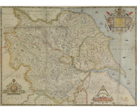
Lot 188
*Yorkshire. Saxton (Christopher), Eboracensis comitatus (cuius Incolae olim Brigantes appellabantur) Longitudine Latitudine hominumque nemero relequis illustrior, [1579], engraved map on two conjoined sheets, contemporary hand colouring and some later enhancement, old folds, some repaired and strengthened, long repaired closed tear affecting image, some marginal repaired closed tears, slight dust soiling, small sepia manuscript vignette added to the right of the mileage scale, one manuscript annotation to map, 535 x 730 mm, mounted, framed and glazed Not examined out of frame. (1)


Lot 19
Elphinstone (Mountstuart). An Account of the Kingdom of Caubul, and its Dependencies, in Persia, Tartary, and India, Comprising a View of the Afghaun Nation and a History of the Dooraunee Monarchy, 2 volumes, new and revised edition, 1839, hand-coloured aquatint frontispiece to each, large folding engraved map, uncoloured aquatint plate, some light spotting, armorial bookplates of Edward and Marianna Heron-Allen, original blindstamped cloth, spines a little faded with tiny tears at head, 8vo (2)

Lot 726
Essex House Press. Dante Map, by Mary Hensman, printed by The Guild of Handicraft, Essex House... from the drawing of John Williams and published by David Nutt, 1892, 2 folding hand-coloured lithographed maps, printed on one sheet (as published), 550 x 870 mm, signed with initials in black ink to lower right outer corner, with 51-page accompanying printed booklet, bound together in original cloth, a little rubbed and faded to spine and outer edges, 8vo (1)

Lot 62
Cary (John). Cary's New and Correct English Atlas: Being a New Set of County Maps from Actual Surveys..., 1793, advertisement leaf, engraved title and dedication leaf, general map of England & Wales, and forty-six (complete) engraved maps with contemporary outline colouring, with tissue guards, near contemporary half sheep, spine rubbed and frayed at head & foot, 4to Chubb CCLXI (1)
Lot 522
Enock (C. Reginald). The Andes And The Amazon, Life and Travel in Peru, 3rd impression, 1908, colour folding map to rear, 4 colour plates and 58 black and white illustrations, including detached portrait frontispiece, period inscription to front endpaper, some light spotting, original gilt decorated blue cloth, spine slightly faded and rubbed to head and foot, 8vo, together with Freeman (Lewis R.), In The Tracks Of The Trades..., 1921, 49 black and white illustrations, including partially detached frontispiece, bookplate to front pastedown, original gilt decorated green cloth, spine slightly rubbed to head and foot, 8vo, and Grubb (W. Barbrooke), An Unknown People In An Unknown Land..., 2nd edition, 1911, 60 black and white illustrations, period inscription to front endpaper, some light marks, original gilt decorated blue cloth, boards and spine slightly marked and rubbed, 8vo, plus other late 19th and early 20th century Americas reference, including History of the Rise and Fall of the Slave Power in America, volumes 1 & 2, by Henry Wilson, circa 1870, mostly original cloth, some leather bindings, G/VG, 8vo/4to (2 shelves)

Lot 164
*Staffordshire. Speed (John), Stafford, Countie and Towne with the ancient Citie Lichfeild described, published Thomas Bassett & Richard Chiswell, [1676], hand coloured engraved map, inset town plans of Stafford and Lichfield, elaborate strapwork cartouche and mileage scale, slight thinning to image, central fold strengthened on verso, 385 x 510 mm, English text on verso, mounted, framed and double glazed (1)

Lot 127
Glamorganshire. Speed (John), Glamorgan Shyre with the sittuations of the cheife towne Cardyff and ancient Landaffe described, 1st edition, published John Sudbury & George Humble, [1611], hand coloured engraved map, inset town plans of Cardiff and Llandaff, slight dust soiling and wear to margins, 385 x 510 mm, English text on verso (1)
![Bible [English]. The Bible, that is, the Holy Scriptures conteined in the Olde and Newe Testament, translated according to th](https://cdn.globalauctionplatform.com/602f3499-4c56-45fa-acbd-a7a900c85218/6ec972bb-e0dc-4110-87ce-f410dd82d6a8/468x382.jpg)
Lot 279
Bible [English]. The Bible, that is, the Holy Scriptures conteined in the Olde and Newe Testament, translated according to the Ebrew and Greeke, and conferred with the best translations in divers languages..., imprinted at London by the Deputies of Christopher Barker, 1599, woodcut general title not present, printed general title and New Testament woodcut title both present, several woodcut illustrations, woodcut map of the Holy Land to verso of Aaa2 following New Testatment title, text in roman type, occasional stains (generally in good condition with good margins), bound with Book of Common Prayer at front, dated 1636, and undated Booke of Psalmes at end (both complete), two blank leaves at front of volume with extensive early manuscript notes in brown ink (not easily legible), light dampstain to lower margins towards rear of volume, Ggg7 with printing flaw and associated closed tear to lower portion, without loss, endpapers renewed, near contemporary gilt-decorated full calf, rebacked with original spine laid down, with a little loss to head and foot, remains of clasps, rubbed and marked, thick 4to Herbert 253 (with the error in Psalmes, LXXIII, 27 'that they' corrected to 'they that'). With 17th century ownership inscription 'Janne Martin Hur Booke' to blank verso of the final leaf of OT, and another inscription in a different hand to verso of part title preceding Psalmes 'Janne Martin daughter of Thomas Martin was Baptised the Elevent of june 1617'. (1)


Lot 144
Moxon (Joseph). A Map of all the Earth and how after the flood it was divided among the sons of Noah, Paradise or the Garden of Eden with the Countries circumjacent Inhabited by the Patriachs, Israels Peregrintions or the Forty Years Travels of the Children of Israel..., The Travels of St. Paul and other the Apostles..., [and] Canaan or the Land of Promise..., circa 1710, together five uncoloured engraved 'bible maps' by Moxon and Visscher, old folds, some repaired marginal closed tears, one map with extended margins, each approximately 325 x 455 mm (5)

Lot 113
British Isles. Munster (Sebastian), Tubula Europae I, published Basle, circa 1545, hand coloured woodcut map within a trapezoidal frame, two panels of text listing the ancient tribes of Ireland and Britain, slight finger soiling to margins, 260 x 340 mm, Latin text on verso displayed within an engraved frame decorated with classical scenes R. W. Shirley, Early Printed Maps of the British Isles, no.37. (1)

Lot 130
Herefordshire. Speed (John), Herefordshire described with the true plot of the citie Hereford as also the armes of thos Nobles that have bene intituled with that Dignitye, published Thomas Bassett & Richard Chiswell, [1676], uncoloured engraved map, inset town plan of Hereford, very slight waterstaining, 385 x 515 mm, English text on verso, together with The Counti of Warwick the shire towne and citie of Coventry, 1st edition, published John Sudbury & George Humble, circa 1611, uncoloured engraved map, inset town plans of Warwick and Coventry, trimmed with loss to vertical strapwork margins, central fold torn with loss, 385 x 510 mm, English text on verso, together with Worcestershire described, 1st edition, circa 1611, uncoloured engraved map, inset town plan of Worcester, trimmed with loss to strapwork margins, central fold split and worn with slight loss, repaired on verso, slight worming, 385 x 505 mm, English text on verso, with Stafford countie and towne with the ancient citie Lichfeild described, 1st edition, published George Humble, circa 1611, uncoloured engraved map, inset town plans of Stafford and Lichfield, trimmed with loss to vertical strapwork margins, central fold frayed and torn with loss, crudely repaired on verso, 390 x 495 mm, English text on verso, plus Shropshyre described..., 1st edition, published George Humble, circa 1611, uncoloured engraved map, inset town plan of Shrewsbury, trimmed with loss along lower margin, central fold discoloured and with slight fraying, 380 x 510 mm, English text on verso, and Anno Darbieshire described, 1st edition, published John Sudbury & George Humble, circa 1611, uncoloured engraved map, inset town plan of Derby, trimmed with slight loss to left hand vertical strapwork margin, some worming affecting image, marginal closed tears, 385 x 505 mm, English text on verso (6)

Lot 40
Pennant (Thomas). The View of India Extra Gangem, China, and Japan, & The View of The Malayan Isles, New Holland, and The Spicy Islands (Outlines of the Globe, volumes III and IV), 1800, folding engraved map to each volume, bookplate of the Rt. Hon. Sir John Trolope to front pastedown of each volume, contemporary gilt-decorated full tree calf, slightly rubbed and minor wear to joints and extremities, 4to (2)
Lot 774
Bernieres (Louis de). Captain Corelli's Mandolin, 1st edition, 1st issue, 1994, slight marginal toning, original white boards (spine ends a little bumped), dust jacket, 8vo, together with Birds Without Wings, 2004, map endpapers, original red cloth, slipcase, 8vo, limited signed edition 309/1000, plus A Partisan's Daughter, Harvil Secker/Blackwell Collector's Library, 2008, original cloth-backed boards, slipcase, 8vo, limited signed edition 49/100, with four other limited editions including Gunter Weber's Confession, 2001 and A Day Out for Mehmet Erbil, 2008 (7)
![Ogilby (John). The Roads from York to Whitby and Scarborough in Yorkshire, [1698], hand coloured engraved strip road map, dec](https://cdn.globalauctionplatform.com/602f3499-4c56-45fa-acbd-a7a900c85218/5f14ca05-ac5a-4247-b2ea-4aa4863e3e14/468x382.jpg)
Lot 150
Ogilby (John). The Roads from York to Whitby and Scarborough in Yorkshire, [1698], hand coloured engraved strip road map, decorative cartouche showing a surveyor using a waywiser, some creasing, 330 x 450 mm The third state of John Ogilby's maps, printed by Abel Swall and Robert Morden. Sheet no. 100. (1)
Lot 515
Jeans (T.T.). Reminiscences of A Naval Surgeon, 1st edition, 1927, 26 black and white illustrations including portrait frontispiece, front endpaper inscribed by the author to 'Lady Brocklehurst... Christmas 1930', some minor toning, original blue cloth, spine lightly faded and rubbed to head and foot, 8vo, together with Department of Defense, publisher, The "Magic" Background of Pearl Harbor, volumes 1-5 (bound in 8), USA, 1977-78, black and white map endpapers, ex library copies with associated stamps and marks, uniform original gilt decorated blue cloth, 4to, and other modern naval and aviation reference and related, including publications by Pen & Sword, Grub Street, Sutton, Putnam, P.S.L., Conway, mostly original cloth in dust jackets, G/VG, 8vo/4to (5 shelves + a carton)
Lot 137
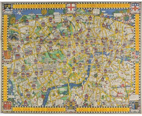
London. Gill (Macdonald), The Wonderground Map of London Town, published The Westminster press, circa 1928, colour photolithographic map, old folds, 745 x 930 mm This is the slightly smaller and later edition of Gill's original 1913 map.There is a subsequent 1924 edition which was altered to help the promotion of the 1924 British Empire Exhibition that was held at Wembley between April and October of that year. It can be identified by a sign saying:- 'On To Wembley' and an empire lion in the top left hand corner below the man pushing a bus. This example is a slightly later state with a greyhound replacing the lion. Greyhound racing started at Wembley in 1927 so this edition probably dates from 1927 or 1928. The map remains highly stylised and whimsical and was held in great affection by Londoners. It was originally commissioned by The London Underground and was designed to be displayed in tube stations. The intense pictorial content of the map caught the public's imagination and as a result Gill is often credited with creating a resurgence in the genre of decorative map making. Much work and research has been done by Roderick Barron and Bryars & Bryars on the maps of the Underground and the work of Macdonald Gill and I am also grateful to Claire Dobbins book, London Underground Maps: Art, Design and Cartography. (1)

Lot 584
Jigsaw map. Asia in its Principal Divisions, By J. Spilsbury, 1767, hand-coloured engraved map pasted onto wood and dissected along country boundaries, approximately 37 pieces, lacking two (Sumatra and possibly Dzungaria), two pieces chipped and one split, a couple very slightly warped, lightly dust-soiled and marked, 43 x 47cm (17 x 18.5ins), contained in near contemporary wooden box with sliding lid This rare map of Asia is one of a series of four 'dissected' maps of the continents then known (i.e. without Australia) produced by 26-year-old London engraver, John Spilsbury. They are believed to be the first purpose made jigsaw puzzles. (1)

Lot 38
Naval Intelligence Division. A Handbook of Arabia, Volume 2 only (of 2), Routes, Prepared on behalf of the Admiralty and the War Office, Admiralty War Staff Intelligence Division, May, 1917, ink stamps in red & black to title (including Imperial War Museum stamp), withdrawn ink stamp to front free endpaper, nine black & white plates, two folding maps only contained in rear pocket (of 5 in total, only one called for in vol. 2 'Key map of Routes' which is present & maps 1-4 called for in vol. 1, map 4 also present in this volume), key map of routes with repaired closed tear, few other ink stamps (including lower edge of pages), endpapers renewed, original cloth, rebacked, without fastening flap at foredge of covers, 8vo (1)

Lot 9
Bohun (Edmund). A Geographical Dictionary: representing the present and ancient names of all the countries, provinces, remarkable cities, universities, ports, towns, mountains, seas, streights, fountains, and rivers of the whole world..., 2nd edition, corrected and enlarged, together with several useful maps not in the former edition, printed for Charles Brome, 1691, additional engraved title by Sturt, printed title in red and black, double-hemisphere engraved world map to verso of A8, 4 folding engraved maps of Africa, America, Asia, and Europe by Robert Mordern, some light browning, contemporary ownership signature of G. Woodward, dated 1724 to front endpaper, contemporary panelled full calf, rubbed and a little wear, with some leather loss to foot of spine, 8vo Wing B3453. (1)
Lot 286
Cervantes Saavedra (Miguel de). El ingenioso hidalgo Don Quixote de la Mancha..., nueva edicion corregida por la Real Academia Espana, 4 volumes, Madrid, Joaquin Ibarra Impresor de Camara de S. M. y de la Real Academia, 1780, engraved and printed titles to each volume, engraved portrait of Cervantes by Carmona after Joseph del Castillo, engraved head- and tail-pieces, single folding map, and 31 fine proof engraved plates by Muntaner, Fabregat, Selma, Moles and others after Joseph del Castillo, some light spotting to preliminary leaves, leaf BB2 at rear of first volume with short closed tear to fore-margin, marbled endpapers, contemporary gilt-decorated full calf, slightly rubbed and minor wear to joints and extremities, with upper cover to first volume loosening, contained in two modern purpose-made slipcases, large 4to Provenance: From the library of the celebrated bibliophile Granville Penn of Stoke Poges, who purchased a large portion of the library of the English poet Thomas Gray at auction in 1845, and subsequently offered his own library at Sotheby's between 1851 and 1854. A 19th century pencil note to the front of the first volume states 'Fine Impressions - a very large Set - from the 'Extensive and Choice Library - Removed from Buckinghamshire'. (Penn.) - 4 volumes'. Palau 52024. Cohen-De Ricci 218-219. Large Paper copy. Approximately 1600 copies of this edition were printed, with no expense spared on the production, making it one of the major examples of 18th century Spanish typography. (4)

Lot 157
Satirical map. European Revue. Kill that Eagle, published Geographia Ltd, London, 1915, colour lithographic map of Europe after J. H. Amschewitz, old folds, a few folds strengthened on verso, 515 x 655 mm An unusual German counter version of British artist J. H. Amschewitz's original December 1914 satirical map of the Euopean war. Both Johnson Riddle's November 1914 map 'Hark! Hark! The Dogs do Bark!' and Amschewitz's 'European Revue...,' published just a few weeks later, elicited a curious propoganda counter blast from the Hamburg publisher Walter Nölting in 1915. He re-produced both maps for the German domestic market. Nolting claimed that the Amschewitz map was clear documentary evidence of Albion's perfidy. His claim was based on Winston Churchill's statement that despite the war Great Britain would continue with 'business as usual' (the legend is written large across the body of England). Nolting chose to misinterpret the statement for propoganda purposes that this latest war is for Britain just 'business as usual' given her historic record and regular propensity for war-mongering. The map reproduces the English text with a few words and phrases transposed into German for better understanding. The last line of German text below the image translates as 'Reproduced by a German printer without kind permission from our English cousin as an eternal memorial'. (1)
Lot 479
Map Reference. A List of Maps of America in The Library of Congress, by P. Lee Philips, reprint edition, 1967, The A.E. Nordenskiöld Collection in the Helsinki University Library, Annotated Catalogue of Maps made up to 1800, volumes 1-3, by Ann-Mari Mickwitz & Leena Miekkavaara, Finland, 1979, Maps and Charts of North America and the West Indies 1750-1789, by John R. Sellers and Patricia Molen van Ee, Washington, 1981, together with 16 further volumes of map reference, mostly original cloth, some in dust jackets, G/VG, 8vo/folio (a carton)

Lot 27
Heylyn (Peter). Cosmography in Four Books. Containing the Chorography and History of the Whole World: And all the Principal Kingdoms, Provinces, Seas, and the Isles thereof..., Revised, Corrected, and Inlarged by the Author himself immediately before his Death, London: Philip Chetwind, 1670, additional engraved title, letterpress title printed in red and black, four folding engraved maps only (of 5, includes map of Europe, Asia, Africa and America, with California shown as an Island), lacking double-hemisphere map, contemporary calf, rebacked, preserving original spine, folio (1)

Lot 152
*Poland. De Wit (Frederick), Regni Poloniae et Ducatus Lithuaniae, Voliniae, Podoliae, Ucraniae, Prussiae, Livoniae et Curlandiae, published Amsterdam, circa 1670, engraved map with contemporary outline colouring, slight dust soiling, 485 x 560 mm, framed and glazed, together with Bowen (Emanuel), A New and Accurate Map of Poland, Lithuania &c. divided into its Palatinates..., circa 1740, hand coloured engraved map, 345 x 425 mm, mounted, framed and glazed, with, Menzies (J. & G.), Poland as divided, circa 1818, engraved map with contemporary hand colouring, 445 x 490 mm, mounted, framed and glazed (3)

Lot 151
Pembrokeshire. Speed (John), Penbrokshyre described and the sittuations both of Penbroke and St. Davids shewed in due form as they were taken..., 1st edition, published John Sudbury & George Humble, [1611], hand coloured engraved map, inset town plans of Pembroke and St. Davids, central fold partially strengthened on verso, 385 x 510 mm, Enlish text on verso (1)
Lot 173
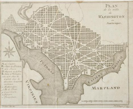
Washington. Ettinger (C. W.), Gorhaischer Hof Kalender..., published Gotha, 1795, small German almanac with an allegorical frontispiece and a decorative title, with a folding engraved city plan of Washington by J. G. Kilnger, with the title 'Plan de la Ville de Washington en Amerique', map measures 160 x 190 mm, the book also contains three historical portraits and twelve engravings of historical scenes, all edges gilt, contemporary marbled card wrappers, 12mo, binding size 105 x 60 mm One of the earliest European published plans of Washington D.C., based on the Andrew Ellicott plan of 1791. (1)

Lot 189
Yorkshire. Bowen (Emanuel), An Accurate Map of the County of York divided into its Wapontakes, drawn from surveys with various improvements..., published J & C Bowles and Robert Sayer, circa 1765, engraved map with contemporary outline colouring, 535 x 700 mm, together with, An Accurate Map of the North Riding of York Shire divided into Wapontakes..., published J. Bowles & Son, T.Bowles & Robert Sayer, circa 1764, engraved map with contemporary colouring, inset view of York, slight staining, 535 x 695 mm, with, An Accurate Map of the West Riding of York Shire divided into Wapontakes..., published T.Tinney, 1753, engraved map with contemporary outline colouring, inset view of Leeds, slight creasing, 545 x 715 mm Originally published in 'The Large English Atlas'. (3)

Lot 172
Wales. Blaeu (Johannes), Comitatus Brechiniae Breknoke, published Amsterdam, circa 1648, engraved map with contemporary hand colouring, 380 x 510 mm, Dutch text on verso, together with Montgomeria comitatus et comitatus Mervinia, published Amsterdam, circa 1650, engraved map with contemporary outline colouring, slight staining, largely confined to margins, 385 x 505 mm, Latin text on verso, with Saxton (Christopher & Kip William),Mongomery comitatus qui olim pars ordovicum, [1607], hand coloured engraved map, slight creasing, 265 x 320 mm, Latin text on verso, plus Flint comitatus quem ordovices olim incouerunt, circa 1610, hand coloured engraved map, 270 x 325 mm (4)

Lot 54
Symes (Major Michael). Relation de L'Ambassade Anglaise envoyée en 1785 dans le Royaume D'Ava ou L'empire des Birmans..., Traduits de L'Anglais avec des notes par J. Castéra..., collection de planches, published Paries, 1800, printed title and contents list, folding engaved map of Burma, large folding map of the course of the River Irrawaddy, with short closed handling tear and one longer repaired closed tear affecting image, twenty-eight (complete as list) uncoloured engraved plates of buildings, costumes, botany and genre scenes relating to Burma, slight spotting throughout, hinges and joints weak, later quarter cloth, spine partially cracked and near detached, rubbed and worn at extremities, 4to (1)
![Turner (Stanley). The United States at War [and] Dated Events Invasion Map of Fortress Europe, published C. C. Peterson, Toro](https://cdn.globalauctionplatform.com/602f3499-4c56-45fa-acbd-a7a900c85218/ac45bb3a-3ce1-4fd8-e473-b26c34e7ce5a/468x382.jpg)
Lot 167
Turner (Stanley). The United States at War [and] Dated Events Invasion Map of Fortress Europe, published C. C. Peterson, Toronto, circa 1943 & 1944, together two large colour printed American propoganda and information maps, each with an additional monotone map to verso, old folds, complete with publisher's printed paper envelopes, each approximately 500 x 660 mm (2)
Lot 181
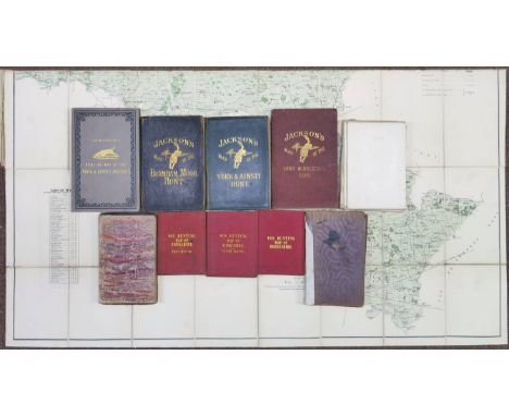
Yorkshire. A collection of eleven folding county maps all relating to Fox hunting countries, 19th century, including Walker (J. & C.), West Riding of Yorkshire, North Riding of Yorkshire [and] Derbyshire, circa 1860, together three engraved folding maps, sectionalised and laid on linen, contemporary outline colouring, each approximately 335 x 410 mm, marbled endpapers, uniform contemporary red cloth gilt boards, together with Jackson (Richard, publisher), Jackson's Map of the York and Ainsty Hunt, Jackson's Map of the Bramham Moor Hunt [and] Jackson's Map of the Lord Middleton's Hunt, circa 1900, together three lithographic maps, sectionalised and laid on linen, contemporary outline colouring, each approximately 825 x 940 mm, printed advertising endpapers, two maps with contemporary limp morocco with gilt decorated upper boards, worn and frayed, and one in contemporary cloth gilt, a little worn at extremities, with another loose copy of the York and Ainsty, plus Masser (J F. & Sons), Map of the Bramham Moor Hunt. Dedicated by Permission to George Lane Fox Esquire and the Members of the Hunt, 1874, colour lithographic map, sectionalised and laid on linen, 650 x 840 mm, marbled endpapers, contemporary morocco, frayed and worn and lacking upper board, with another copy similar, bound in contemporary cloth, boards faded and stained with spine crudely repaired, and Sampson (John), Map of the York and Ainsty Hunt, Dedicated by permission to Captn. Slingsby, Scriven Park, and the Members of the Hunt, 1881, colour lithographic map, sectionalised and laid on linen, 900 x 965 mm, contemporary cloth boards with gilt decorated upper siding, with another copy similar (11)

Lot 147
North Pole. North Pole. Coronelli (Vicenzo Maria), Terre Artiche descritte Dal. P.M.Coronelli M.C. Cosmografo della Serrenis Republica di Venetia....., published Venice, circa 1690, uncoloured engraved map of the North pole, the northern continents with a naive depiction of glaciers, windhead cartouche, 455 x 600 mm Moreland & Bannister, page 73. (1)
Lot 7
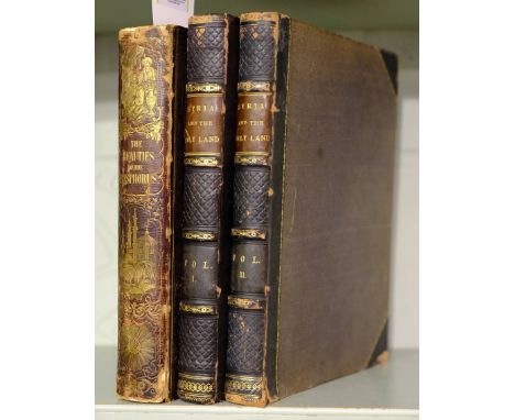
Bartlett (W.H., illustrator). The Beauties of the Bosphorus; by Miss Pardoe, Illustrated in a Series of Views of Constantinople and its Environs, 1838, portrait frontispiece, additional title, engraved map and 78 engraved plates, some spotting and light toning, all edges gilt, contemporary embossed morocco gilt, spine and edges a little rubbed and scuffed, 4to, together with Syria and the Holy Land Illustrated: In a Series of Magnificent Engravings... From Drawings on the Spot by W.H. Barlett and T. Allom; and Descriptions by J. Carne, 2 volumes, circa 1861, three additional engraved titles, two engraved maps, 115 engraved plates, occasional light spotting and toning, top edges gilt, contemporary burgundy half morocco, a little rubbed and scuffed, 4to (3)
Lot 51
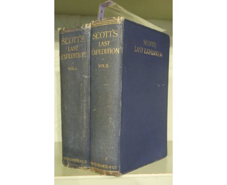
Scott (Captain R.F.). Scott's Last Expedition, 2 volumes, 2nd edition, 1913, photogravure portrait frontispiece to each, colour and black & white plates and maps, occasional light spotting, bookplate, top edge gilt, original blue cloth, slightly rubbed, large 8vo, together with Lecture Advertisement leaflet, Town Hall , Birmingham. Under the auspices of the Council of the Birmingham and Midland Institute, on Tuesday, November 4th, at 8, Commander Evans C.B., R.N., wil deliver a Lecture on "Capt. Scott's Expedition"..., [1913], 4pp. advertisement leaflet printed in red & black, with black & white portraits from photographs and map, central horizontal fold and short repaired closed tears (3)
Lot 119
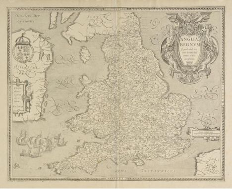
England & Wales. Le Clerc (Jean), Anglia Regnum si quod aliud in toto Oceano ditissimum et florentissimum, published Paris, 1606, uncoloured engraved map, large ornate cartouche and mileage scale, slight staining to lower margin but not affecting image, near contemporary ink manuscript numbers to upper left and lower right corners, 385 x 480 mm, no text on verso R.W.Shirley. Early Printed Maps of the British Isles 1477 - 1650, no.271. Uncommon. A slightly reduced, but close copy of the Saxton/Ortelius map of 1602. (1)

Lot 154
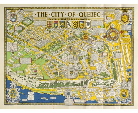
Quebec. Maw (S. H.), The City of Quebec with historical notes, published Alexander & Cable, Toronto, 1932, bright colour lithographic folding map, decorated with heraldic shields and a large compass rose, old folds, 645 x 845 mm, supplied with publisher's printed paper envelope A highly decorative pictorial map, very much in the style of Macdonald Gill. A note in the lower right corner states 'Dimensions & proportions must not be taken seriously. It being the intention of the author only to amuse and instruct'. (1)
Lot 162
South America. Moll (Herman), To the Right Honourable Charles Earl of Sunderland and Baron Spencer of Wormleighton, One of Her Majesty's Principal Secretaries of State &c. This Map of South America according to the newest and most exact observations..., published J. & T. Bowles, P. Overton & John King, circa 1730, engraved map on two conjoined sheets, contemporary outline colouring, inset view of the mines at Potosi, repaired closed tears, old folds repaired and strengthened on verso, torn with slight loss to image, repaired on verso, slight toning, 590 x 970 mm, together with Price (Charles), South America corrected from the observations communicated to the Royal Society of London and Paris, sold by T.Brandreth & G.Willdey..., circa 1720, engraved map after Senex, contemporary outline colouring, frayed with slight loss along left hand vertical margin, worn with loss along central fold, 900 x 640 mm, with Bourne (E.), South America with its Political Divisions compiled from state papers and observations, Astronomical, Nautical and Historical by E. Baker, published R. Wilkinson, 1806, engraved map with contemporary hand colouring, slight spotting largely confined to margins, 525 x 620 mm (3)
Lot 21
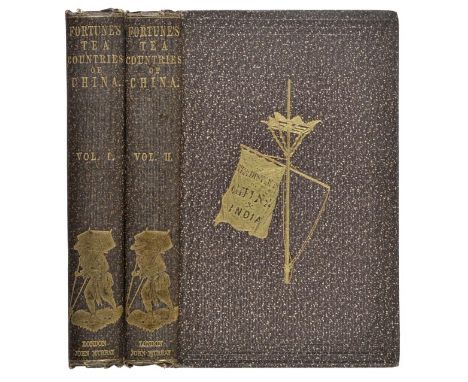
Fortune (Robert). Two Visits to the Tea Countries of China and the British Tea Plantations in the Himalaya..., 2 volumes, 3rd edition, John Murray, 1853, wood engraved frontispiece to each volume (both laid down to front pastedown), additional decorative and printed titles to each volume, single folding engraved map at rear of first volume, wood engraved plates and illustrations, original gilt-decorated cloth, slightly rubbed and a few minor marks (generally a good copy), 8vo (2)

Lot 165
Staffordshire. Blaeu (Johannes), Staffordiensis comitatus vulgo Stafford Shire, published Amsterdam circa 1648, engraved map with contemporary hand colouring, slight spotting, largely confined to margins, small hole affecting image, 410 x 505 mm, French text on verso, together with Comitatus Northantonensis vernacule Northamptonshire, published Amsterdam, circa 1650, uncoloured engraved map, trimmed to plate mark on vertical margins, 390 x 510 mm, no text on verso, with Morden (Robert), Westmorland, [1695], uncoloured engraved map, slight offsetting, 360 x 425 mm, plus Cary (John), A Map of Westmoreland, circa 1800, uncoloured engraved map, 400 x 485 mm, and Saxton (Christopher & Kip William), Cumbria sive Cumberlandia qua olim pars Brigantum, [1637], hand coloured engraved map, 290 x 330 mm, with Morden (Robert), North Wales, circa 1695, hand coloured engraved map, 360 x 430 mm, mounted (6)

Lot 68
Lewis (Samuel). A Topographical Dictionary of England..., 5 volumes (including Atlas), 1831, folding linen-backed engraved map of England & Wales, folding plan of London (both with closed tears), forty-three engraved county maps (some folding), occasional spotting, original cloth, spines faded and with some fraying at head & foot, large 4to (5)
Lot 906
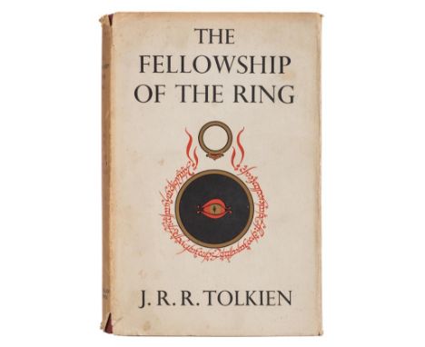
Tolkien (J.R.R.). The Fellowship of the Ring, being the first part of the Lord of the Rings, 1st edition, George Allen & Unwin, 1954, folding map at rear printed in red and black, minor browning to endpapers, original red cloth, covers with some damp discolouration to front edges (front cover with approximately half the surface area affected), in slightly soiled and frayed dust wrapper (price unclipped), spine darkened and with very minor loss to extremities, 8vo (1)

-
108737 item(s)/page