

RITCHIE HENRY: (1876-1958) Henry Peel Ritchie. British Royal Navy Captain. Ritchie received the first Victoria Cross awarded to naval personnel during the First World War for his courageous actions in November 1914, which left him seriously wounded. Attractive signed printed 5.5 x 4.5 card `H. Peel. Ritchie´, being a printed drawn map entitled `BISERTA´. The map shows the Bizerte lake and city close to the Mediterranean coast, also showing the mountains and lakes surrounding and the roads leading to the city. Boldly signed by Ritchie to the lower white border. Tear to the left lower corner not affecting the map or the signature and small remnants of former affixing to the verso, otherwise about VG £100-150The Victoria Cross is the highest and most prestigious award for valor that can be given to members of the British armed forces. Bizerte, also known as Bizerta, is a town in Tunisia, the northernmost city in Africa.
We found 109198 price guide item(s) matching your search
There are 109198 lots that match your search criteria. Subscribe now to get instant access to the full price guide service.
Click here to subscribe- List
- Grid
-
109198 item(s)/page


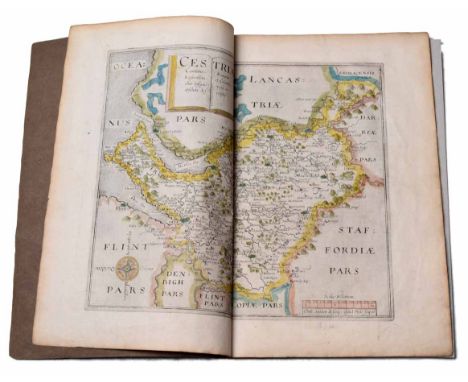


Christopher Greenwood (1786 - 1855) and John Greenwood (fl. 1821 - 1840), Map of the County of Lincoln, from an Actual Survey Made in the Years 1827 & 1828 [...], Published by Greenwood & Co., London, Corrected to the Present Period and Published, January 26, 1831, Engraved by Josiah Neele, vignette of Lincoln Cathedral to margin, steel engraving with hand-colouring, 66cm x 74cm


Various ephemera, prints, pictures, etc., Whose Who In World Cricket, Biographies of Famous World Players, Home Gardener 1967, a News Chronicle 60 Old Time Variety Songs song book, various 20thC coloured postcards, Fraser (Antonia) Cromwell Our Chief of Men, hardback, book plates prints, Silver Jubilee Royal Map of Succession pamphlet, etc. (a quantity)

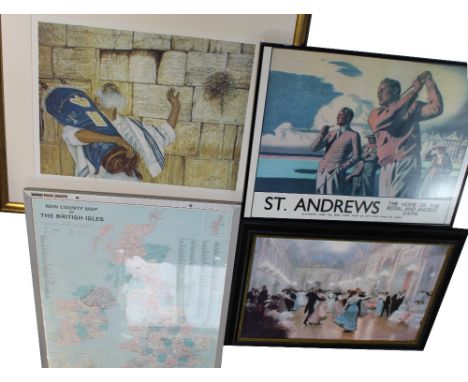
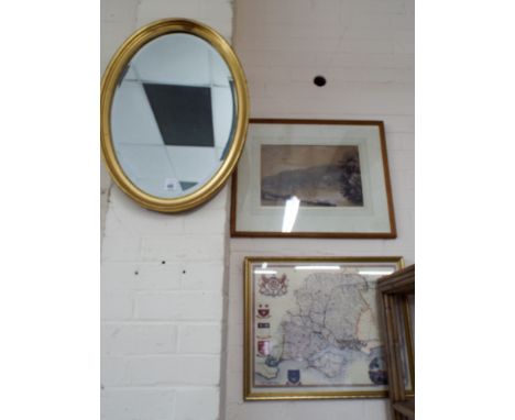
A Nobo Mag-Map of 'New County Map of the British Isles', 85 x 70cm, framed and glazed, a large decorative print of an Edwardian ballroom scene, a printed golf-related poster for 'St Andrews the Home of the Royal and Ancient Game' and a signed limited edition print, no.293/500, a Rabbi with a copy of the Torah in prayerful pose by the Wailing Wall Jerusalem, signed lower-right, 54 x 69cm (3).


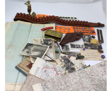
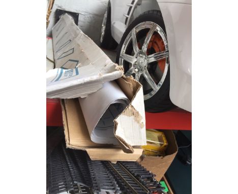
An interesting mixed group of militaria to include WWII period military issue map of Bastia (air) and two early 20th century Ordnance Survey maps of Belgium and Germany, ephemera to include Service and Release books, Signal Wing of School of Infantry booklet, photographs and official documents, also a Christmas 1914 tin, mixed badges and buttons, leather cartridge belt etc.


After Richard Bloome, 'A Generall mapp of North Wales' hand coloured engraving, 34 x 46cm (PL), together with a engraved map of England and Wales published by J Badeslade, an 18th century map of Europe titled 'Cumen Historiarum per Occidentem ex Canabitus' by Fran Haraei and an 18th century map of Europe titled 'Europa' by Annae Seile.


Moleiro Editions Facsimile, Atlas Miller, five sheets printed both sides, colour with gold highlights, limited edition of 987 copies, this being no.122, Barcelona, 2003, with signed certificate, 60 x 42cm and a Superior Dissected Map jigsaw, England and Wales, boxed, (incomplete), also a copper map plate.

20th Century souvenir fans for historical events and geographical locations, including two fans celebrating the 100th Wimbledon ladies tennis tournament in 1993, printed with a painting by Muriel Mallows, three 1955 Thomas Cook fans promoting Spain, together with another displaying five cartouches containing scenes of the Likang river with a map on the verso and more (approx.55)
!["The Gentleman's Magazine or Monthly Intelligencer" Sylvanus Urban, Gent [Edward Cave], near full run, 1732 through 1894, vol](https://cdn.globalauctionplatform.com/8e0e513c-0daa-4d57-bf2b-a8c000aca67c/c481f58c-c9f4-408f-b172-36996eb78181/468x382.jpg)
"The Gentleman's Magazine or Monthly Intelligencer" Sylvanus Urban, Gent [Edward Cave], near full run, 1732 through 1894, vol 1 of 1731 not present, 1751 plates of Niagara missing, 1772 maps missing, 1740 maps missing, 1775 also missing maps, 1776 has the US Declaration of Independence and no maps, 1787 the US Constitution, the Gentleman's Magazine founded by Edward Cave was a longstanding periodical, with early works by Samuel Johnson among other scientific, philosophical, artistic and literary contributions, many plates and maps, some folding, frontis removed from most vols, vol 20 1750 folding plates including a map "A Prospect of Vulcan's Court, Near Putzol in Naples", folding plate "A View of the Inside of St Stephens, Walbrook, London built after the design of Sir Christopher Wren", a folding plate with details of various bridges, including The Bridge of Guillotiere, over the Rhone at Lions in France, Pont du St Esprit, a bridge over the Rhone in Languedoc, France, The New Bridge over the Thames at Walton, The New Bridge over the Thames at Westminster", also foldinh plates of Vesuvius and Aetna errupting; vol 32 for the year 1767, frontis, folding plate, map of 'The Mogul's Empire divided into its principal governments', engraved plate opposite page 64 'The Manners and Customs of the Greenlanders' showing man fishing in a canoe, men in a hut cooking and harpoons, this vol quarter leather, marbled boards, raised bands, gilt titles, the majority of all the vols are with detached boards, loose and split bindings and in general need of repair ,bought as seen (not collated other than maps missing, already stated, 3 shelves and boxes ,ex-library) PLEASE NOTE 1775 AND 1776 DO NOT HAVE THE AMERICAN MAPS


Geikie, Sir Archibald"The Ancient Volcanoes of Great Britain", 2 vols, MacMillan & Co 1897, numerous ills, original green cloth with gilt titles, library bkpl and barcode Smith, Philip (ed) "A History of Egypt Under the Pharaohs... by Dr Henry Brugsch-Bey", 2nd edition, 2 vols, John Murray 1881, folding map to vol 1, numerous ills, original cloth but front board and backstrip detached to vol 1 (4)

Johnston, T B and Robertson, Col James A "The Historical Geography of the Clans of Scotland", 2nd edition, W & A K Johnston 1873, large folding linen map, original binding but front board and backstrip detached, the map is loose, library bkpls inside front board Bogg, Edmund"2000 Miles on Wandering in the Border Country Lakeland and Ribblesdale", publ Edmund Bogg 1898, numerous ills throughout, library lending plate and barcode, front board detaching, original blind decorated cloth with gilt titles (2)
Lady Sale ( Florentia, wife of Sir Robert Henry Sale) 'A Journal of the Disasters of Affghanistan 1841-2', John Murray 1843, blind stamped and gilt pictorial cloth, back strip splittingEdwardes, Major Herbert E. ' A Year on the Punjab Frontier in 1848-49', Lahore 1963 and 1964, 2 vols, col. frontis to vol II, tissue guard, plates, folding map, red cloth, 'Lahore' stamp and name of ffep.Smyth, Major G. Carmichael (ed.) 'A History of the Reigning Family of Lahore...'. Lahore 1961, folding map , red clothBurnes, Lieut.-Col. Sir Alexander 'Cabool....' Lahore 1961, plates, red cloth with King, Col.J. Anthony 'Twenty Four Years in the Argentine Republic....', Longman, Brown, Green and Longmans 1846, bookplate, blindstamped cloth, Myers P.V.N. 'Remains of Lost Empires' Harper and Brothers 1875, frontis, ills. plates, marbled boards and end papers, half leather rubbed and Lucas Bridges E. 'The Uttermost Part of the Earth' Hodder and Stoughton 1948, frontis portrait, 2 folding maps, photographic plates, green cloth, dec ep (8)

Cary, John "Cary's New and Correct English Atlas Wales and Scotland: being a new set of county maps from actual surveys... navigable canals... directions for the junction of the roads from one county to another", printed for John Cary, engraver and map seller, January 1st 1793, index to the preceding routes, all maps have tissue guards, all within a leather slip case with marbled board to the flap, bkpl inside front cover and pen inscriptions on ffep, commentating on the purchaser in 1815, 47 maps

Hawksworth, John "An Account of the Voyages Undertaken by the Order of his Present Majesty for Making Discoveries in the Southern Hemisphere and Successfully Performed by Commodore Byron, Captain Wallace, Captain Carteret and Captain Cook in the Dolphin, the Swallow and the Endeavour...", in three vols, printed for W Strahan and T Cadell 1783, maps mainly disbound, does include the map of the Straits of Magellan, all maps appear to have been trimmed one way and another, vol 1 has 17 maps and charts and three plates, vol 2 has 8 maps and charts and 14 plates, in vol 2 from pages 279 to 410 major damp damage, the pages have been stuck together and are stuck and there is bookworm damage, vol 3 has 6 charts and maps and 6 plates, all 3 vols half leather with marbled boards and marbled ep, but a lot of damp damage and backstrips boards detached and worm damageCook, Captain James and King, Captain James "A Voyage to the Pacific Ocean Undertaken by the Command of His Majesty for Making Discoveries in the Northern Hemisphere...", in 3 vols, printed for G Nicol and T Cadell 1784 (Cook's Third Voyage), 7 maps/charts in vol 1, 10 maps/charts in vol 2 and 3 maps/charts in vol 3, bound uniformly with Cook's First Voyage, marbled boards, half leather, backstrips damaged and with loss, again some damp damage (6)


-
109198 item(s)/page