We found 109198 price guide item(s) matching your search
There are 109198 lots that match your search criteria. Subscribe now to get instant access to the full price guide service.
Click here to subscribe- List
- Grid
-
109198 item(s)/page


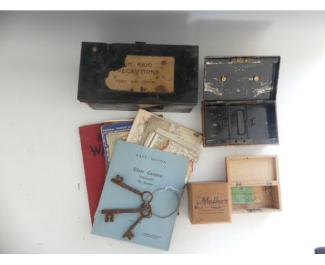
Lot 313
A quantity of vintage maps, printed ephemera and collectibles, including General Guide Map to the District of Honiton 1916, 'Three Corners - Awliscombe' house sale brochure dated 27.09.1966, Daily Mail War Atlas including Air-View Map of the Western Front, vintage Ministry of Transport map cards showing roads and railways, W.W.II Air Raid Precautions First Aid Outfit tin and contents with instructions for 'Gas Treatment', etc (a lot)


Lot 2284
the yellow cross motif with a marquise cut synthetic sapphire centrally, to beadwork decoration, on a woven chainpendant length 5.1cm, chain length 70cmThe pieces are in good condition however the surface of the synthetic sapphire is abraded. It fastens with S-shaped clasp. Both are stamped 'K22' and 'MAP.' and in our opinion would test as gold. Gross weight 29.3 grams. CR made 13.09.22.


Lot 7
The Collection Of Bernard Hill - The Lord Of The Rings; The Fellowship Of The Ring (2001) - Hill's personal Wrap Party invitation from the movie, held at Shed 21, Waterloo Quey, Wellington on 22nd December 2000. The invitation being a custom printed artwork design map of Middle Earth, with an embossed emblem seal. Party details to reverse. A4. Supplied with an autographed 8x10" colour photograph of Hill in his role as King Theoden in the franchise.

Lot 84
The Collection Of Bernard Hill - The Lord Of The Rings (2001-2003) - a collection of memorabilia from production, to include; one of Hill's call sheets dated 4th December 2000 carrying the secret title ' Jamboree '. The call sheet being a two-page document detailing various information for the production on that day. Along with a separate A4 page with map and directions to Edoras - signed by Hill in black ink. The documents accompanied by an original crew-only LOTR transport service t-shirt (black, size S, by Cotton Force).

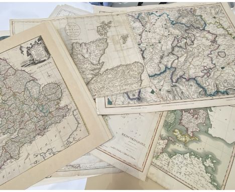
Lot 175
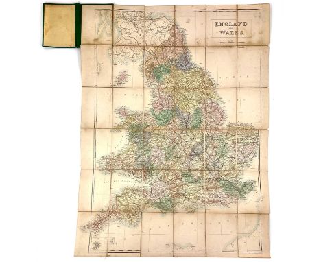
A large collection of 17th and 18thc maps of counties and boroughs in Scotland and England including a map after J Carey, a new correct map of the North part of Scotland, Thomas Kitchbum - a new map of England and Wales, an 1832 map of Peebles, Selkirk, a new map of the Kingdom of Denmark 1825 etc, approximately 25, various sizes in art folio


Lot 493
After Robert Morden, a map of Suffolk, 38 x 45cm, together with a collection of 19th century and later pictures and prints, to include a pair of 19th century reverse pictures on glass, each 25 x 35cmThree reverse pictures on glass are not cracked but do have some losses to the colour and marks which show as white in the images. All are pictures are very dirty and the frames are rough.


Lot 89
GWR Pictorial Enamel Map THE CORNISH RIVIERA GREAT WESTERN RAILWAY MAXIMUM OF SUNSHINE ENGLAND'S NATIONAL HEALTH & PLEASURE RESORT. This is the extremely rare, small version measuring approximately 14.25in x 12.25in. In good condition with a some small areas of restoration mainly around the edges and slight fading.


Lot 64
Graves (Rev. John)The History of Cleveland ..., Carlisle: Printed by F. Jollie, 1808, quarto, folding map (linen backed), nine engraved plates as called for, folding pedigree, calf [Boyne p.189];Charlton (Lionel), The History of Whitby and of Whitby Abbey ..., York: T. Cadell et al., quarto, folding plan and plates as called for (repaired tear to plan), half calf (front hinge split);Thoresby (Ralph), Ducatus Leodiensis: or the Topography of ... Leedes ..., Maurice Atkins, 1715, folio, 12 (of 13) maps and plates (coin plate not found, loss to some plates), overtaped half calf:with two others (5)
Lot 3229
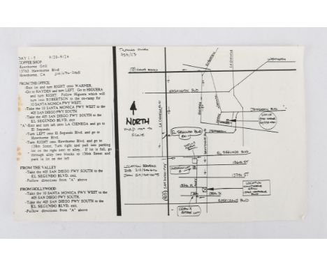
Pulp Fiction (1994) Original First Day of Production Memorandum, September 20, 1993: & Original Film Production Map, September 20-24, 1993.- the first a memorandum sent to the cast, crew and staff on the first day of shooting from production manager, Paul Hellerman, 1pp. typescript on a single white sheet, Brown Productions logo top left corner, Pulp Fiction logo and Culver City, California, address lower centre, Well, were up and running! I just wanted to take this opportunity to welcome all the new folks to Pulp Fiction . . . I think its going to be a great shoot and a great movie!, the production manager advices that his door is always open and details specific guidelines under the headings, On-Set Personnel and Visitors to Set and 'Wrap Beer, Drugs and the Like, 8.5 x 11 inches, stapled together with a production map for use during shoot days 1-5, 9/20-9/24, a 1pp. single sheet, with a hand-drawn map and typescript directions to the Coffee Shop location Hawthorne Grill, Hawthorne Blvd., California from various main points such as, from the office, from the valley and from Hollywood, 8.5 x 14 inches.Provenance - the vendor was a crew member and is credited in the film's end titles. Pulp Fiction, directed by Quentin Tarantino won the Palme d'Or at the 1994 Cannes Film Festival and Best Original Screenplay at the 67th Academy Awards, the film was was nominated for seven awards including nominations for John Travolta, Samuel L. Jackson and Uma Thurman. The film's title refers to the pulp magazines and hardboiled crime novels popular during the mid-20th century.Condition Report: light creasing and scrolling to corners, some stains to l.h. edge of the typescript directions from use on the production.


Lot 348
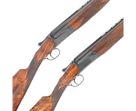
A pair of 12-bore 'MX8 MAP' single-trigger over-and-under ejector guns by Perazzi, no. 48308/9Hold-open toplevers, single-triggers with manual safety-slides, the blacked action-bodies with border-scroll engraving, the well-figured stocks (No.2 replacement with a crack rear of the lower tang) with rubber recoil-pads, the barrels (No.1 loose on the action, No.2 slightly loose on the action) engraved 'Perazzi, Brescia, Made in Italy' with matt ventilated top-ribsNo.1 - Weight 7lb. 0oz., 14½in. pull (13⅝in. stock), 27½in. barrels, approx. ⅝ & Full chokes, 2¾in. chambers, Italian nitro proofNo.1 2nd barrels - 28½in., approx. ⅜ & ½ chokes, 2¾in. chambers, Italian nitro proofNo.2 - Weight 7lb. 4oz., 14½in. pull (13½in. stock), 27½in. barrels, approx. ⅝ & Full chokes, 2¾in. chambers, Italian nitro proofNo.2 2nd barrels - 28½in., approx. ⅜ & ½ chokes, 2¾in. chambers, Italian nitro proofIn their plastic cases with two sets of spare barrelsThis lot is subject to the following lot symbols: S2S2 Section 2 lots require a valid British Shotgun certificate, RFD (Registered Firearms Dealer) Licence or import licence.For further information on this lot please visit Bonhams.com

Lot 10
Geographical game.- Walker's tour through England & Wales, a new geographical pastime, hand-coloured engraved map, some staining, dissected and linen-backed, folding into original marbled board slip-case, large engraved title and small publisher's labels, nicked, a few chips, rubbed, [Whitehouse Table games of Georgian and Victoria days, p.13], 540 x 650mm., published for the author by W. and T. Darton, 2nd January, 1809.

Lot 12
Hampshire.- Warner (Richard) and D.Y. Collections for the History of Hampshire...Including the Isles of Wight, Jersey, Guernsey, and Sarke, 5 vol. bound in 3, engraved frontispiece and 60 plates (2 hand-coloured), 1 folding engraved map, bound without the 'Plan of the Form of Jersey' as usual, vol. 1 extra-illustrated with numerous plates and illustrations, some laid-down to verso of plates called for, occasional light toning or spotting, bookplate of Michael Matantos, contemporary marbled calf, rebacked, some corners worn, rubbed, Printed for the Author, [1795]; and others, many on Hampshire, v.s. (c.25)
Lot 15
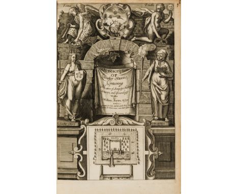
NO RESERVE Leicestershire.- Burton (William) The Description of Leicester Shire. Containing Matters of Antiquitye, Historye, Armorye, and Genealogy, first edition, engraved portrait (bound at end) and pictorial title by Francis Delaram, engraved folding map by William Kip after Christopher Saxon (loose), later ink ms. index and notes to front free endpapers, some spotting or light foxing or staining, engraved armorial bookplate of Edward Conyers of Walthamstow, 20th century calf, gilt spine in compartments and with brown leather label, spine ends and corners worn, joints split, but holding firm, rubbed, [STC 4179], small folio, Printed [by William Jaggard] for Iohn White at the holy lambe in litle Brittaine neare vnto Aldersgate Street, [1622].
Lot 150
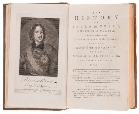
Jacobite author.- Russia.- Gordon (Alexander) The History of Peter the Great, Emperor of Russia. To which is prefixed, A short general history of the country, from the rise of that monarchy: and an account of the author's life, 2 vol., first edition, list of subscribers, 3 engraved portraits (2 as frontispieces), folding engraved map, final advertisement f., vol.1 2E4 short tear at foot, touching 3 letters, but without loss, occasional spotting or light staining, contemporary calf, gilt spines in compartments and with red and black morocco labels (the reds new but sympathetic), a few stains, rubbed and marked, a solid set, 8vo, Aberdeen, Printed by and for F. Douglass and W. Murray, 1755.⁂ Around 1692 Gordon travelled to Russia. He was introduced to the Czar, who was sufficiently impressed to make him a major in the Russian army. Within a few months he was promoted to lieutenant-colonel, rising later to major-general. He fought for the Jacobites in the 1715 rising.

Lot 19
NO RESERVE Angling.- Grimble (Augustus) The Salmon Rivers of England and Wales, 1913; The Salmon Rivers of Scotland, 1913; The Salmon Rivers of Ireland, 1913, third editions, contemporary ink gift inscriptions to front free endpapers, map frontispieces and photographic plates, some light foxing, uniformly bound in original vellum-backed boards, uncut, lightly soiled, spine labels faded and rubbed, 8vo (3)
Lot 3
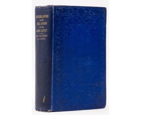
Balkans.- Paton (A. A.) Highlands and Islands of the Adriatic, including Dalmatia, Croatia and the Southern Provinces of the Australian Empire, 2 vol. bound in 1, first edition, tinted lithograph frontispieces, vignette titles, 8 tinted lithographs, folding map and plan, scattered spotting, previous owner's school presentation letter pasted to front pastedown, original blind-stamped cloth, a little rubbed, slight bumping to corners and extremities, 8vo, 1849.

Lot 4
Cyprus.- Meikle (Desmond) Wild Flowers of Cyprus, one of 200 copies signed by the author, artist and publisher, 40 colour plates by Elektra Megaw, original morocco-backed marbled boards, t.e.g., 1972 § Bannerman (David A. & W. Mary) Birds of Cyprus, colour plates, illustrations, folding map, dust-jacket bound in, modern half green morocco, g.e., 1958, half-titles, bookplate of Michael Matantos, spines lightly sunned; and 3 others on nature in Cyprus, handsomely bound, v.s. (5)

Lot 2220
James Bond Skyfall (2012) - A Bullet Blank fired from Raoul Silvas Helicopter. Mounted inside a framed display with a corresponding still & descriptive plaque. Accompanies a Ground Test Instruction from Agusta Westland who built the Helicopter used in the Film, together with a crew map of Hankley Common where the scenes were filmed. Provenance: Obtained from one of the Films Prop Masters. 13 x 9.5 inches.

Lot 2425
Jurassic Park (1993) - A miniature display containing a piece of Prop Visitor Map used in the Film. Together with a VHS Cassette tape signed on the front sleeve by Ariana Richards who played Lex in the Film. With presentation box & Certificate of Authenticity. Cassette signed at The London Film & Comic Con, Friday 8th July 2022.

Lot 566
Globus - - Drehbare Sternenkarte von J. Schultz. Dresden um 1928, bezeichnet "Drehbare Sternkarte in Verbindung mit dem Ost-, West-, Nord- und Südhorizont von Joachim Schultz, 3. Auflage, Verlag Emil Weises Buchhandlung (Karl Eymann) Dresden", Pappe, bedrucktes Papier, montiert auf schwarzem gedrechseltem Holzfuß, die Vorderseite mit Sternenhimmel über dem südlichen Horizont, die Rückseite mit Sternenhimmel über dem nördlichen Horizont. Höhe: ca. 51 cm. Ein zweidimensionaler Himmelsglobus, die Universalkarte ersetzt zum Teil Himmelsglobus und Armillarsphäre.A revolving celestial map by J. Schultz.Dresden/Saxony c. 1928, signed "Drehbare Sternkarte in Verbindung mit dem Ost-, West-, Nord- und Südhorizont von Joachim Schultz, 3. Auflage, Verlag Emil Weises Buchhandlung (Karl Eymann) Dresden", cardboard and printed paper, mounted on ebonised turned wooden stand. Height c.51 cm.
Lot 577
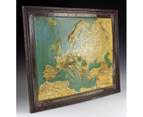
Globus - - Seltene Europa-Reliefkarte von Bauerkeller. Darmstadt, um 1844, bezeichnet "Europa von Bauerkeller, Darmstadt, Bauerkeller's Prägeanstalt, Jonghaus & Venator", u.a. bearbeitet nach Berghaus, Grimm, v. Humboldt, Ritter, Stieler und Zeune, Farblithographie im Flächen-Prägedruck, Papiermaché, in originalem braun gefassten Metallrahmen montiert (bestoßen). Maße mit Rahmen: ca. 69 x 57 cm.Sehr seltene Ausgabe einer Europa-Reliefkarte in dieser um 1840 von Georg Michael Bauerkeller (1805-1886) neu entwickelten Technik des Flächen-Prägedrucks. Sein Halbbruder Georg Leonhard Bauerkeller (1809-1848) gründete 1844 mit Gustav Jonghaus (1807-1870) und Reinhard Ludwig Venator (1799-1862) in Darmstadt eine Filiale der Pariser Prägeanstalt Bauerkeller et Cie. "...man braucht aber nur die von ihm erst herausgegebenen Karten vom Montblanc und der ganzen Schweiz zu betrachten..., um den Fortschritt zu bemessen, welchen er in dieser Kunst herbeiführte." Aus Jomard, über Relief-Landkarten, Polytechnisches Journal 1843, Bd. 87, S. 307-314: "Entscheidend für die Genese der Firma Bauerkeller war die Entwicklung von großformatigen Karten im Flächen-Prägedruck in Kombination mit Papiermaché. Die erste belegbare Landkarte in dieser neuen Technik ist die hier gezeigte Karte "Die Schweiz und angrenzende Länder" (Paris 1842). Vgl. Ausstellung "Bildwerke des Wissens", Bilderschatz durch 450 Jahre Uni- und Landesbibliothek, Hessisches Landesmuseum Darmstadt 02. Nov. 2017.A rare Bauerkeller relief map of Europe. Darmstadt/Germany c. 1844 "Europa von Bauerkeller, Darmstadt, Bauerkeller's Prägeanstalt, Jonghaus & Venator", chromo-lithographed relief-print, paper-maché, mounted in original brown metal frame (small damages). Size c. 69 x 57 cm. - Rare early edition of a relief map of Europe in a new printing technical developed by Georg Michael Bauerkeller (1805-1886).

Lot 579
Globus - - Reliefkarte von Europa. Paris, um 1872, bezeichnet "Carte pysique de l'Europe en relief" und "Europe par C. Kleinhans, Ch. Delagrave Edit., 58, Rue des Ècoles, Institut Geographique de Paris", die Rückseite mit Verlagsanzeige der verschiedenen Angebote von Karten und Globen, Gips, Pappe, gerahmt. Altersspuren. Größe mit Rahmen: ca. 37 x 33 cm.A relief map of Europe.Paris c.1872, signed "Carte pysique de l'Europe en relief" and "Europe par C. Kleinhans, Ch. Delagrave Edit., 58, Rue des Ecoles, Institut Geographique de Paris", plaster, cardboard, framed. Signs of age. Size c. 37 x 33 cm.


Lot 438
JOHN SPEED. 'Somerset-Shire described'. 'and into Hundreds devided with the plott of the famous and most wholsom waters and citie of the Bathe,' hand coloured copper engraved map, coat of arms, city plan of Bath, water damage to centre fold, English text to verso, framed and glazed, sold by Thomas Bassett in Fleet Street and Richard Chiswell in St Pauls, London, circa 1610. 40cm x 53cm Somerset-Shire Described, by John Speed, hand coloured engraving, 17th Century,

Lot 457
THOMAS KITCHIN ( (1718-84). A New Improved Map of Cornwall,' 'from the Best Surveys and Intelligencies Divided into its Hundreds,' partially hand coloured copper engraved map, no centre fold, some very light spotting to an otherwise very good copy, embellished pictorial title, dedication within baroque cartouche, inset map of The Isles of Scilly, Howgarth frame and glazed, printed for Carington Bowles, London, 1779. 59cm x 76.5cm (frame)

Lot 458
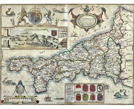
CHRISTOPHER SAXTON and LEA PHILIP. 'Cornwall Described...' 'by C. Saxton, Corrected & many Additions as the Roads etc. by P. Lea,' hand coloured copper engraved map, centre fold, toning, the royal coat of arms sits above a panorama of Launceston, eight heraldic coats of arms, an ornate cartouche and mileage scale, Howgarth frame and glazed, P. Lea, London, 1694. 37cm x 49cmThis map does not appear to be laid down. Centre fold, ink line approx 4cm to the 'coat of arms', very light blue paint has run into the 'Cornwall' cartouch, toning throughout as expected, some sporadic (very light) foxing. A good example, with a strong imprint and skillfull hand colouring.Please visit our website for high resolution photographs (both front and back).

Lot 55A
Seven 19th century books on Cornwall. C. TRELAWNY COLLINS. 'Peranzabuloe, The Lost Church Found....,' original pebbled cloth, frontis, vg textblock, J. G. & F. Rivington, London, 1836; 'A Guide to the Mount's Bay and Lands End,' by a Physican, second edition, original cloth, vg textblock, 1824; F. W. L. STOCKDALE. 'Excursions in the County of Cornwall,' full leather with gilt decorations to spine, plates, fold out map, 1824; JONATHAN COUCH (with THOMAS Q. COUCH). 'The History of Polperro,' original green cloth with gilt decorations, fold out frontis, spotting to titlepage, W. Lake, Truro, 1871; With three others. (7)
Lot 53
WILLIAM GEORGE MATON. 'Observations....Western Counties of England,' 'Observations Relative Chiefly to the Natural History, Picturesque Scenery, and Antiquities of the Western Counties of England, Made in the Years 1794 and 1796,' first edition, two vols, rebound, plates, tears to folds of mineralogical map, some finger soiling, Salisbury, 1797. (2)

-
109198 item(s)/page