We found 109198 price guide item(s) matching your search
There are 109198 lots that match your search criteria. Subscribe now to get instant access to the full price guide service.
Click here to subscribe- List
- Grid
-
109198 item(s)/page


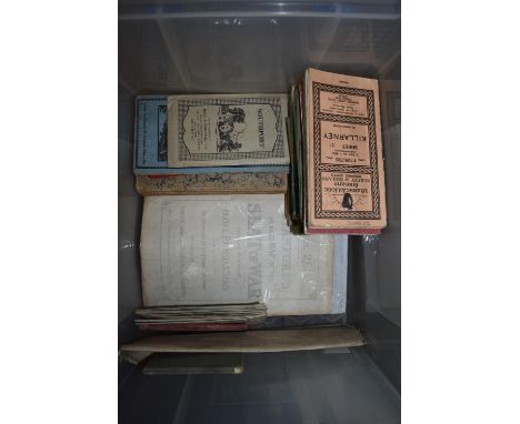
Lot 279
FOLDING MAPS: a collection of approx 33 folding maps, chiefly 19th-early 20thc, to include a number of O.S Irish maps, 'War Map of the Middle East' issued W & A K Johnston: a large French regional map: 'Stanford's Enlarged Map of the Seat of War, embracing the whole of France, Prussia & Spain': Cary's 'New Map of Northumberland', 1821, hand-coloured, etc. (A carton)
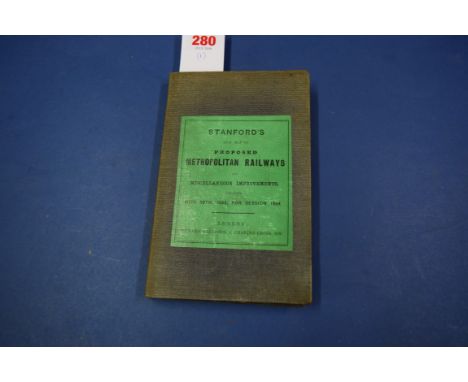
Lot 280
FOLDING MAP: STANFORD (Edward): 'Stanford's New Map of Proposed Metropolitan Railways and Miscellaneous Improvements deposited Nov. 30th, 1863, for session 1864...', London, Edward Stanford: folding map of London showing railway and transport routes, printed on paper and laid down on linen, approx 90 x 73cm, folding down into publishers grey cloth boards, printed label to upper, light water stain and some browning, generally in good condition. (1)

Lot 281
LONDON MAPS: C Smith & Sons Tape Indicator Map of London: E J Larby, Limited, n.d: together with 'Bacon's New Map of London and Illustrated Guide', both folding maps on linen, green and brown cloth boards respectively, the former bound up with printed list of streets at front and with cloth measuring tape, generally in good condition. (2)

Lot 282
LONDON MAPS: CARY (J, Mapmaker): 'Cary's New Pocket Plan of London, Westminster and Southwark; with all the adjacent buildings in St Georges Fields &c...', London, J Cary, 1790: folding map with contemporary hand colouring, printed on paper and laid on linen, folding down into 18 sections, original marbled paper slipcase with printed label to one side, splits at conjunction of some folds, some creasing and browning, a few old pen marks: together with another similar, split along several folds and again with a few later pen markings. (2)

Lot 283
LONDON: Gaul & Inglis Handy Map & Guide to London, circa 1900, folding map in original green cloth boards: together with 2 other folding London maps, plus Cook's Handbook for London 1893 and 'London in Miniature', pub. Frederick Warne & Co in the Warne's 'Bijou Books' series, with folding map frontispiece, condition variable. (5)

Lot 285
METRO-LAND: 'Metro-Land..containing a comprehensive and descriptive review of the various districts served by the Metropolitan Railway..', promotional booklet, 112pp with folding map, photographic illustrations (some in colour), original colour printed wrappers, hard-bound into red cloth gilt (publishers?), spine ends a little chipped, otherwise good. Uncommon. (1)


Lot 289
LONDON MAP: 'Cary's New Map of London, and its adjacent villages, published by order of his Majesty's Postmaster General, showing the present boundary of the 2-penny post delivery, and the limits of the Hackney Coach Hack Fairs'. London, G & J Cary, 1836. Copper engraved map with contemporary hand-colouring, printed on paper and laid on linen, folding into 28 sections, original marbled paper slipcase with printed label to one side, the map approx 84 x 77cm unfolded: cluster of worm tracks to centre of middle 2 panels and one other, small ink splat lower right, scattered foxing, otherwise in good condition. (1)

Lot 291
LONDON MAP: 'Pigot & Co's New Map of the Environs of London, extending 14 miles round in every direction...', London, J Pigot & Son, 1832: steel engraved map, printed on paper and laid on linen, dissected into 6 sections, engraved view of Thames banks to lower margins, some browning and a few splits at conjunction of folds, without slipcase, dust marked. (1)
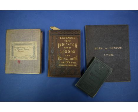
Lot 292
LONDON MAPS: 'Contoured Map of the Thames Basin..', Ordnance Survey Office Southampton, 1870: folding map in 36 sections, printed on paper and laid onto linen, original purple cloth boards with printed label to upper: together with 3 other London maps, including 'Extended Tape Indicator Map of London and Visitor's Guide', C.Smith & Son circa 1880, and a 19thc facsimile of the 1799 London survey. (4)
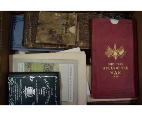
Lot 293
FOLDING MAPS: a collection of approx 25 folding maps, 19th-20thc, including Jeffery's 'Map of the Roads of England & Wales with the Exact Distances by the Milestones between Town and Town..', small hand-coloured folding map with slipcase, worn and browned: 'Stanford's General Map of the Germanic Confederation...', circa 1870: 'Johnston's War Map of Europe..showing the seats of operations in the Black Sea and the Sea of Azov, the Baltic and White seas, etc..', W & A K Johnston, 1855: 6 separate maps printed onto paper, contained within publishers red cloth slipcase, gilt lettered to one side: and others. (A tray)

Lot 295
DISTRICT RAILWAY MAP: 'The Improved District Railway Map of London, 1882': third edition: large colour printed map on paper laid onto linen and folding down into printed cloth covers, browned and rather worn, a few splits to folds or sections lifting: together with approx 23 other items, mainly 20th century promotional brochures from British railway companies, a few Ian Allan publications, etc. (A packet)

Lot 296
FOLDING MAPS: a collection of 19th-20thc maps, including a folding map of the South & West Wiltshire Hunt, other British County maps by Philips, OS, Bacons, etc: together with a disbound and defective 19thc juvenile book featuring British County maps set within hand-coloured pictorial borders. (Small box)

Lot 297
LONDON: 'Collin's Standard Map of London with Guide and 3000 Street References...', London, Edward Stanford, 1874: folding hand-coloured map printed on paper and laid onto linen, folding into 32 sections within publishers brown cloth boards, blue printed label to upper, a few marks and creases else in good condition: together with: LOCKIE (John): 'Topography of London; giving a concise local description of, and accurate direction to, every square, street, lane, court, dock, wharf, inn, public-office &c in the Metropolis and its environs...', London, Sherwood, Neely and Jones, 1813. Second edition, 12mo, later half-calf: with one other guide relating to London. (3)

Lot 299
LONDON MAPS: BOWLES (Carington, publisher): 'A Modern Map of the Countries 25 miles round London, drawn from accurate surveys and engraved by J Ellis...', n.d., circa 1790: copper engraved folding map, printed on paper and laid on linen, folding into 16 sections, original marbled paper slipcase with printed label to one side, generally in very good condition: together with 9 other folding maps of London. (10)

Lot 300
FOLDING MAPS: a collection of approx 26 folding maps, 19th-20thc, including 'Central Europe: comprehending France and Austria, with the intermediate states of Holland, Germany, Prussia, Italy &c', pub. London by Whittle & Laurie, 1816: copper engraved folding map, contemporary hand-colouring, original slipcase with printed label: together with other mainly British and Irish county maps, plus a group of 9 folding maps extracted from London directories and a disbound historical atlas. (A tray)

Lot 407
PHOTOGRAPH ALBUMS, WORLD WAR I: interesting group of photo albums, including a number of images from early in first war, including motor cyclists and transport, 7th Bt. Devonshire Regt. Hartlepool Aug 1914, bicycle company Aug 16th 1914: a series of images from a country house military hospital in 1915, inc. interior ward views, nurses in kitchen and group photographs etc: together with a carton of miscellaneous other material, including 2 early 19thc scrapbooks, one later scrapbook, trench map, cartes de visite, vintage tape measure in leather case. (A box)

Lot 427
LONDON: a collection of booklets, guides and ephemera relating to London, largely cross-period 20thc publications with a few earlier noted, including 'Kew Gardens Popular Guide with Map...' souvenir for 1908, third edition, pub. Gale & Polden, a few folding maps etc, condition generally sound, approx 50+ items. (A box)

Lot 547
POSTERS, MAPS, ETC: a large tube containing rolled posters, maps, etc, to include poster advertising film 'The Great St Trinian's Train Robbery': political poster 'The Budget League. The Wolf', anti-food taxes poster, circa 1920: rolled OS map of Preston District, large scale: a few signed etchings etc. (A tube)
![After John Ogilby (1600-1676),'The Road from Glocester to Montgomery, North Wales' [sic],hand coloured strip map,34 x 46 cm](https://cdn.globalauctionplatform.com/152d313f-a1b2-4eda-b3b4-a8dc00ce5adf/e0278e88-d3fa-4a85-e754-a50c2ab0c42e/468x382.jpg)


Lot 260
A Album of Falkland Island Dependencies Mint Stamps from 1944 to 1984. noted a detailed comprehensive study of the 1946 thick map set showing major and minor printing flaws colour shades, plate blocks, part sheets etc. Queen Elizabeth 1954 set to £1 with extra shades. A very good lot with interest throughout


Lot 428
Small Selection of Home Front Itemsconsisting alloy Victory bell cast from German aircraft shot down over Britain 1939-45 ... White metal tubular ARP whistle ... WW2 pattern jack knife ... French made propaganda toy box ... Trench art bullet letter opener ... WW2 RAF silk escape map J3/J4 covering Italy. 6 items
!["Severus Alexander, as Caesar, Æ26 of Antioch, Seleucis and Pieria. AD 221-222. MAP AVPHΛI AΛЄΞANΔPOC [KЄ], bare-headed, drap](https://cdn.globalauctionplatform.com/d7f2130e-d626-4cb2-b7ea-a915011373da/cb3a2d64-a31e-4e88-d064-5b858dcb4ef7/468x382.jpg)
Lot 457
"Severus Alexander, as Caesar, Æ26 of Antioch, Seleucis and Pieria. AD 221-222. MAP AVPHΛI AΛЄΞANΔPOC [KЄ], bare-headed, draped and cuirassed bust right, seen from behind / ANTIOXЄΩN MHTPO KOΛ, Tyche seated on rocks left, holding grain ears; below, river-god swimming left; Δ-Ɛ and S-C across fields. McAlee 823b. 10.59g, 26mm, 1h.Near Very Fine. Rare; no other examples on CoinArchives."


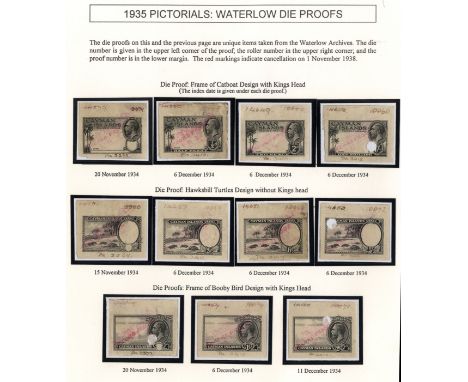
Lot 218
1935 Pictorial issue, the unique series of working Die Proofs from the Waterlow archive, twenty in all. Master Die of King's Head (as for Northern Rhodesia 1925 high values); Catboat and Booby Bird vignettes; three Map design without King's Head, undenominated, ¼d and 3d; three vertical Conch shell designs without King's Head, undenominated, 1½d and 10/- (these three cut into at right); four Catboat frame designs, undenominated, ½d, 2d and 1/-; four Turtle designs without King's Head, undenominated, 2½d, 6d and 5/-; three Booby Bird designs with King's Head, undenominated, 1d and 2/-. Each with Die number, roller number, proof number and with manuscript CANCELLED/1.11.38/RECORD PROOF (date of Dies' destruction) in red. Four with punch holes, some faults and light soiling as appropriate for these working proofs. On two exhibition pages. Ex Marston, Cooley and Maisel. For SG 96-107

Lot 256
1946 Thick Map set in complete unmounted mint sheets of sixty. ½d, 1d and 2d sheets Plate 3, 3d Plat 1 4d Plate 4, 6d, 9d and 1/- Plate 2. The ½d and 1d sheets have marginal blemishes and the ½d with three stamps creased. Six broken arcs on each sheet; the 3d with missing 'I', extra island, extra dot by oval and 'teardrop'; the 6d, 9d and 1/- each with SOUTH POKE. SG G1-8 (£2244)


Lot 474
1975-1994 unmounted mint collection of definitives in blue binder, quite a comprehensive range with a large number of Plate/imprint blocks with many reprints. We note 1980 Aborigines blocks with long imprint, 1982 24ct Map 12 blocks including the rare Plate 117 (CP $800); 1982 Minerals, Fruit and Birds ($10 original and one Kiwi blocks of four); 1988 Birds and range of self-adhesives in strips; 1991-6 Butterflies Liegh-Mardon or Questa blocks; 1994 $20 imprint block and a few later


Lot 491
BLAEU (WILLEM JANSZOON) MAP OF ENGLAND AND WALES 1649, handcoloured, 40 x 51cm, J Blaeu two maps of Worcestershire and Montgomeryshire 1645-50 and c, hand coloured, lightly stained, the second somewhat more so and J Speed, two maps of Nottinghamshire and Caernarvonshire, 1610 or later, hand coloured, the first lightly browned, the second fresh and well coloured (5)


Lot 10
Camera (Matteo). Historia della citta e Costiera di Amalfi, in due parti divisa, Naples, 1836, folding map and 12 engraved plates, engraved vignette title and tail-pieces, errata to final leaf verso, foremargins closely trimmed, a little scattered light browning, old cloth, slightly rubbed, 8vo (1)
![Africa. Chatelain (Henry Abraham), Carte particuliere de l'Egypte de la Nubie et de l'Abyssinie..., [and] Carte de la Barbari](https://cdn.globalauctionplatform.com/8bf1a529-a787-46bf-861d-a91c00d38464/ce1070d2-8bce-4435-99d6-8fa143d6c2ad/468x382.jpg)
Lot 105
Africa. Chatelain (Henry Abraham), Carte particuliere de l'Egypte de la Nubie et de l'Abyssinie..., [and] Carte de la Barbarie, Nigritie et de la Guin‚e avec les pays voisins..., circa 1719, two uncoloured engraved maps of north and west Africa, each approximately 405 x 510 mm, together with Coronelli (Vicenzo Maria), Abissinia doue sono le Fonti de Nilo..., Venice, circa 1695, uncoloured engraved map, inset map of the course of the River Nile, 450 x 600 mm (3)

Lot 106
Americas. Seutter (George Matthaus), Novus orbis sive America meridionalis et septentrionalis per sua regna provincias et insulas..., circa 1730, engraved map with contemporary outline colouring, two large uncoloured cartouches, insular California, very slight spotting, short split at base of central fold, 500 x 580 mm (1)

Lot 109
Australia. Bellin (Jacques Nicolas), Carte reduite des Terres Australes..., published Paris, 1753, engraved map, old folds, 210 x 285 mm Originally published in Prevost's 'Histoire Generale des Voyages'. A geographically naive 'pre Cook' map showing the Eastern coastline of Australia running unbroken from Tasmania up to New Guinea. (1)

Lot 110
Australia. Arrowsmith (John), Australia from surveys made by order of the British Government combined with those of D'Entrecasteaux, Baudin, Freycinet &c. &c., 1847, large engraved map on two sheets with contemporary outline colouring, slight dust and finger soiling, each sheet approximately 650 x 520 mm, together with Map shewing the surveyed lands of Port Philip from the government surveys made in 1840, engraved map with contemporary outline colouring, slight offsetting, two areas of staining, 615 x 490 mm (2)
-
109198 item(s)/page