We found 109198 price guide item(s) matching your search
There are 109198 lots that match your search criteria. Subscribe now to get instant access to the full price guide service.
Click here to subscribe- List
- Grid
-
109198 item(s)/page


Lot 2748
Lightly duplicated selection in stockbook from QV to 1960, a mixture of mint and used including 1891-1902 to 1s, KEVII 6d, 1s, 1912-20 MCA to 1s incl 2d, 2_d blocks of 4, 1918-20 war stamps incl 1s used (2), 1921-28 script to 1s incl odd block of 4, 1933 Centenary 1_d, 3d blocks of 4, 1935 Jubilee set in blocks of 4 (1s m/m, others used), 1937 Coronation _d, 1d in sheets of 60, 1938-50 to £1 incl 2s 6d (4), 5s and 10s (3 each) and £1 (2) and a few blocks of 4 to 1s 3d, also good heavily duplicated selection of Falkland Island Dependencies 1946-49 Map types in seven volumes with a number of minor unlisted varieties noted (Few Hundreds)
Lot 2755
Airmail:1930 First Airmail Flight from Paris to Bagdad, CIDNA (Compagnie Internationale de Navigation AŽrienne) label produced for the above and depicting a flight route map with a plane above, inscribed 'INAUGURATION DU/SERVICE POSTAL AERIEN/PARIS BAGDAD', a sheet of 50 imperforate proofs in black with Bradbury Wilkinson imprint at foot, some tones and affixed to card frame by margins with masking tape (on reverse), a most unusual item

Lot 2975
Antarctica: 19-86 mint and used collection neatly arranged on album leaves including Australian Antarctic Territory with three pictorial postcards bearing Australia 3d. Antarctic map cancelled at Macquarie Island, Heard Island and Mawson all with 1954 Expedition label (all different), unmounted mint 1959 2/3d. block of four, 1966-68 to $1, and 'KING EDWARD VII/LAND' 1d. used, Ross Dependency 1957 3c. and 15c. both inverted watermark, u/m, 1972-79 sets to 18c. plate blocks, and covers (8); generally good to fine (hundreds)

Lot 2976
Small eclectic mixture on two stock cards including New Guinea 1935 £2 bright violet used Bulolo cds, Nyasaland 1913-21 MCA 4s variety 'Nick in top right scroll' used with faults, HK 1891 Jubilee 2c, heavily used with colour suffusion, KUT 1935 1s black & blue-green, perf 13 x 12, good cds used, Newfoundland 1897-1918 2c orange right marginal block of 15, mint with most u/m, Canada 1898 2c lavender Map, block of 6, u/m, Spanish Andorra 1972 8p Europa (2) u/m, also four Switzerland Cantonal odds incl Basel Dove 2_r, 5c Double Geneva 5c and Zurich 4r, 6r, these presumed to be forgeries

Lot 3021
Collection in small carton including useful volume of used KGV to early QEII with items of note including Ascension 1934 to 5s, 1956 to 10s, 1963 Birds to £1, BAT 1963 to £1 Map, Br Guiana 1938 to $3, India 1937-40 to 25r, Pitcairn Is 1940-51 to 2s 6d, S. Leone 1938 to £1, Turks & Caicos 1950 to 10s, a similar m/mint vol including Ascension 1938 to 10s, 1956 to 10s, BAT 1963-69 to both £1 (£1 Endurance u/m but short perfs), Br Honduras 1938 to $5, Cayman Is 1962 to £1, Cyprus 1938 to £1, Falkland Is 1952 to £1, Gambia 1938 to 10s, KUT KGVI to £1, Montserrat to £1, N. Rhodesia KGVI to 20s, remainder more general and of little value (Few Thousands)


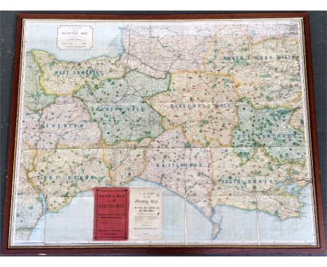
Lot 100
A. H. Swiss, No.6 Hunting Map, scale 1/2" to a mile, Dorsetshire, Somersetshire, Wiltshire, and East Devonshire districts, 1895/96, depicting the West Somerset, Taunton Vale, Tiverton, East Devon, Cattistock, South Dorset, Blackmore Vale, South & West Wilts, and Lord Portman's Hunt countries, 82x100cm

Lot 611
*Documents & Photographs. A collection of approximately 40 manuscript deeds relating to the West Country, circa 1713-1890s, including 35 on vellum, many relating to inhabitants of Cullompton, Devon, Dawlish, also Callington, Cornwall (1718), and Milverton (1724), various sizes, one Latin manuscript document on vellum, probably 15th century, somewhat soiled and a little loss to centre of upper margin, affecting two or three words, the sheet measuring 35 x 9.7 cm, together with a small quantity of 19th century photographs, including 17 views of Benares, Calcutta and Bombay, a view from Fitzgerald Point looking towards Mount Malcolm, etc., an 18th century engraved map of Graecia Homerica, an etching by Luigi Rossini entitled Veduta dei Grandiosissimi avenzi del Tempio di Giove, Rome, 1820 (some spotting and soiling), and a folio album of English pressed flowers and plants, circa 1886-92, each with ink caption, locations including Cambridge, Chetton, Isle of Wight, and elsewhere, original black half morocco, rubbed and a little wear to edges, folio (a carton)

Lot 752
STANLEY, H.M. In Darkest Africa 2 vols. 1st.ed. 1890, London, 8vo orig. gt. dec. cl. plus DECLE, L. Three Years in Savage Africa new ed. 1900, London, 8vo cont. fl. cf. fr. bd. det. lacks 1 map, plus ANON The Life and Explorations of Dr. Livingstone (1882), London, 4to orig. fl. gt. dec. tooled L. (4)

Lot 3009
A Riley Pathfinder Workshop Manual, together with further manuals for The Morris Minor 10-4 and handbooks, A Burrow's RAC County Map and Gazetteer for Leicestershire, Northamptonshire, Huntingdonshire and Rutland, an MGA, MGB 1955-68 Autobook, and two Haynes manuals for Rover 213/216 and Volvo 142/144 and 145. (qty)

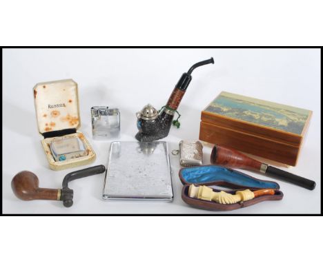
Lot 372
A selection of vintage 20th century smoking related items to include a Meerschaum carved bone pipe depicting holding hands, a French hardwood smoking pipe, an Austrian black wood smoking pipe, a silver white metal engraved vesta, two Ronson lighters including a Ronson Viking, and a map of Britain chrome cigarette case. Box measures 6 cm high and 15 cm wide.

![Bismarck Otto von. Tattica di cavalleria. Napoli, Giuseppe Severino, 1836. In-8° (mm 230x136). XXI (mal numerate), 213, [3] p](https://cdn.globalauctionplatform.com/90a80f41-b834-49df-bf4a-a95a00b40f12/88b4d795-a049-4da4-d67f-47b64952e7bb/468x382.jpg)
Lot 131
Bismarck Otto von. Tattica di cavalleria. Napoli, Giuseppe Severino, 1836. In-8° (mm 230x136). XXI (mal numerate), 213, [3] pagine. Due tavole incise su legno e ripiegate: una carta geografica e uno schema di posizione. Frontespizio litografico. Fioriture. Legatura editoriale in mezzo marocchino con angoli, titolo stampato in nero al piatto anteriore e in oro al dorso. Fregio impresso in nero al piatto posteriore. Lievi abrasioni e aloni. Prima traduzione italiana di questa opera di fondamentale importanza. Stampata per la prima volta in tedesco nel 1819, venne tradotta in francese nel 1821, mentre la prima traduzione in inglese venne stampata nel 1855, con il titolo On the uses and application of cavalry in war. SI AGGIUNGE: Chiari Eduardo. Elementi di podologia: lezioni date al Corso militare di Mascalcia. Parma, Ferrari e Pellegrini Editori, 1891. (mm 190x126). 594, [2] pagine. Numerose illustrazioni nel testo. Alcuni fascicoli allentati, carte lievemente brunite. Brossura editoriale figurata con difetti. Al frontespizio invio autografo dell'autore al presidente della Società Veterinaria Toscana. Tibro della Società Veterinaria Toscana al frontespizio e alla brossura anteriore. Prima edizione. SI AGGIUNGE: Istruzione a cavallo e addestramento ippico per l'arma di cavalleria. Roma, Istituto Poligrafico dello Stato, 1941. (mm 180x115). XI, [1], 246 pagine. Fotografie in bianco e nero a piena pagina. Tela editoriale verde stampata in nero. Bismarck Otto von. Tattica di cavalleria. Napoli, Giuseppe Severino, 1836. 8° (230x136 mm). XXI (misnumbered), 213, [3] pages. Two engraved folding plates: a map and a tactic. Engraved title-page. Publisher's three-quarter morocco, title printed in black on the front cover, in gold on the spine. An ornament printed in black on the rear cover. Light stains and minor defects. First Italian translation of this fundamental work, first printed in German in 1816 and then translated into French in 1821, in Italian and, in 1855, into English with the title On the uses and application of cavalry in war. ADDING: Chiari Eduardo. Elementi di podologia: lezioni date al Corso militare di Mascalcia. Parma, Ferrari e Pellegrini Editori, 1891. (190x126 mm). 594, [2] pages. Numerous illustrations in the text. Some quires loose, leaves slightly browned. Pictorial publisher's wrapper, with defects. Dedication copy addressed to the President of the Veterinary Society of Tuscany, and stamp of this society on the title-page and on the front wrapper. First edition.ADDING: Istruzione a cavallo e addestramento ippico per l'arma di cavalleria. Roma: Istituto poligrafico dello stato, 1941. (180x115 mm). XI, [1], 246 pages. Black and with photos. Green publisher's cloth, printed in black.
Lot 220
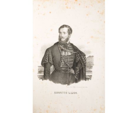
Moti del 1848. Satira/1848 Riots. Satire. Memorie di Vienna. Settembre 1848.Album in-folio obungo (mm 278x430) comprendente 14 tavole litografiche a piena pagina, di cui una ripiegata (mm 294x437), e 2 ritratti litografici. Le tavole sono accompagnate da una carta bianca protettiva e sono firmate dai litografi Franz Werner (Mariahilf Nr 128 in Wien), Carl Lanzedelli e M.R. Toma (Wien). Lievi fioriture sparse. Legatura coeva in mezza tela, piatti in carta marmorizzata, etichetta con titolo manoscritto al piatto anteriore.I ritratti mostrano il politico ungherese Lajos Kossuth e il prete cattolico tedesco Johannes Ronge. Le tavole firmate dal Werner mostrano scene di battaglia (Vicenza, Custoza e Milano), manifestazioni pubbliche a favore della libertà, l'apertura della costituente, barricade, parate e scene parodistiche, tra cui una sull'Ungheria intitolata Ungarns Zustand. Le litografie di Carl Lanzedelli hanno un forte carattere satirico. Una di esse, intitolata 'Illustrirte politische Karte von Östrerreich und den angrenzeden Ländern', mostra la mappa politica dell'Austria e degli stati limitrofi con le diverse reazioni all'indomani dei moti del 1848 (cfr. G. Ravy-J. Benay, a cura di, Satire-Parodie-Pamphlet-Caricature en Autriche à l'époque de François-Joseph 1848-1914, Rouen, 1999, 21).Oblong folio (278x430 mm). The album includes 14 full-page lithograph plates, of which one folding (294x437 mm), and 2 lithograph portraits. The plates are accompanied by protective balnk leaves and are signed by the lithographers Franz Werner (Mariahilf Nr 128 in Wien), Carl Lanzedelli, and M.R. Toma (Wien). Light scattered foxing. Contemporary half-cloth, panels in marbled paper, label with ink title on front panel.The portraits show the Hungarian politician Lajos Kossuth and the German Catholic priest Johannes Ronge. The tables signed by Werner show battle scenes (Vicenza, Custoza and Milan), public demonstrations in favor of freedom, the opening of the constituent, barricades, parades, and parodistic scenes, including one on Hungary entitled Ungarns Zustand. The lithographs by Carl Lanzedelli have a strong satirical character. One of them, entitled 'Illustrirte politische Karte von Östrerreich und den angrenzeden Ländern', shows a political map of Austria and its neighboring states with the different reactions in the aftermath of the 1848 uprisings (cf. G. Ravy-J. Benay, a cura di, Satire-Parodie-Pamphlet-Caricature en Autriche à l'époque de François-Joseph 1848-1914, Rouen, 1999, 21).
Lot 50
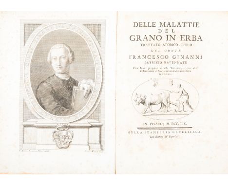
Ginanni Francesco. Delle malattie del grano in erba. Trattato storico-fisico... Con note perpetue ad esso Trattato, e con altre Osservazioni di Storia naturale... Pesaro, Niccolò Gavelli, 1759.In-4° (mm 280x205). xviii, 426 pagine, manca l'ultima carta bianca. L'esemplare appartiente alla tiratura con la carta di errata non segnata (e numerata come pagina 400) inserita tra le carte Ddd3 e Ddd4. Carta di occhietto. Antiporta con ritratto dell'autore, inciso su rame da Pietro Monaco su disegno di Giovanni Andrea Lazzarini. Vignetta calcografica al frontespizio. Iniziali, testatine e finalini calcografici, la testatina alla carta A1 incisa da Zucchi. Una carta geografica ripiegata incisa su rame, con l'iscrizione 'Territorio Ravennate'; 4 diagrammi ripiegati hors texte; 7 tavole incise ripiegate legate in fine. Buon esemplare, stampato su carta forte. Alcuni fascicoli uniformemente bruniti, diffuse fioriture. Legatura coeva in pergamena su piatti in cartone. Dorso liscio, con titolo in caratteri dorati su tassello dipinto. Tagli rossi. Alcune macchie ai piatti; lieve danno all'angolo inferiore esterno del piatto anteriore; cerniere leggermente usurate alle estremità; abrasioni al dorso, in corrispondenza delle cuffie. Erudito studio sulle malattie del grano ad opera del naturalista ravennate Francesco Ginanni (1716-1766), da considerarsi - come osserva Filippo Re nel Saggio di bibliografia georgica (1802) - "in questa materia [...] un autor classico". Gamba 1939; Lastri 60; Niccoli 196; Pritzel 3335; Taccolini, Fonti per la storia dell'agricoltura italiana (1750-1799), 73.4° (280x205 mm). xviii, 426 pages, lacking the last blank leaf. This copy belongs to the issue with the errata leaf unsigned (but numbered as page 400) inserted between fols. Ddd3 and Ddd4. Half-title. Frontispiece with engraved author's portrait by Pietro Monaco after Giovanni Andrea Lazzarini. Engraved vignette on the title-page. Engraved initials, head- and tail-pieces. One folding engraved map depicting Ravenna territory, with inscription 'Territorio Ravennate'; 4 folding diagrams hors texte; 7 folding engraved plates bound at the end. Good copy, printed on strong paper. Some quires uniformly browned, foxing throughout. Contemporary vellum over pasteboards. Smooth spine, title in gilt on painted lettering-piece. Edges red. A few stains to the covers, minor wear to the lower outer corner of upper corner; joints slightly cracked; some losses to extremities of spine. Learned treatise on grain diseases compiled by the naturalist from Ravenna Francesco Ginanni (1716-1766), which - as Filippo Re states in his Saggio di bibliografia georgica (1802) - deserves to be considered 'a classic' on the topic. Gamba 1939; Lastri 60; Niccoli 196; Pritzel 3335; Taccolini, Fonti per la storia dell'agricoltura italiana (1750-1799), 73.

Lot 1371B
Railway Interest. Great Northern Railway to comprise block signalling regulations 1911, engineers department instructions 1920, list of principle officers and list of stations 1914, instructions to servants working over and in 'Foreign companies' lines dated 20-11-1922. System map and two special instructions opening of new line Langley to Hertford and instructions to signalmen at Bourne. (7 ) ute


Lot 104
[Worsley, Richard]. The History of the Isle of Wight, 1781, engraved vignette to title, folding engraved map hand-coloured in outline, 30 engraved plates only (of 31, includes 11 double-page, without double-page plate of Carisbrook Castle), few vignette illustrations, front blank with inscription "Henry Worsley - 13th October 1863, Bought at Yarmouth in my visit to the Island with my beloved wife & Lizzie & Harry", modern calf, contained in slipcase Upcott p.305-307. (1)

Lot 107
Bilton (William). The Angler in ireland: or an Englishman's ramble through Connaught and Munster, during the summer of 1833, 1st edition, Richard Bentley, 1834, uncoloured aquatint frontispiece to each volume, folding lithographic map of 'Cunnemara', splits along old folds of map, bookseller's labels to front pastedowns, contemporary half calf gilt with contrasting morocco labels to spines, slight wear to extremities, 8vo Westwood & Satchell, p.122. (2)
Lot 11
Buxton (Edward North). Short Stalks, Second Series, comprising trips in Somaliland, Sinai, the Eastern Desert of Egypt, Crete, the Carpathian Mountains, and Daghestan, 1st edition, Edward Stanford, 1898, numerous photographic plates including frontispiece, 2 folding maps in end-pockets, light spotting and browning to endpapers and half-title, half-title inscribed 'M de C Findlay, with the authors kind regards, April 1898', bookplate of the recipient Sir Mansfeldt de Cardonnel Findlay to front free endpaper, fore and bottom edges untrimmed, original tan pictorial cloth, spine and portion of front board darkened, corners bumped, faint red stain to lower outer corner of front board, large 8vo, together with Two African Trips, with Notes and Suggestions on Big Game Preservation in Africa, 1st edition, Edward Stanford, 1902, numerous photographic plates including frontispiece, large folding map in end-pocket, edges untrimmed, original tan pictorial cloth, spine nicked and darkened, covers slightly marked, corners bumped, large 8vo, plus Roosevelt (Theodore), Mes chasses en Afrique, traduction de Norbert Sevestre, 1st edition, Paris: Hachette et Cie, 1910, photographic frontispiece, plates, toning, occasional light spotting, top edge gilt, original brown cloth gilt, spine sunned, frayed at foot, large 8vo; and 2 others including a bright copy of Gaetano Casati's Ten Years in Equatoria, 1st edition, 1891, original cloth, volume 2 only Presentation copy of Short Stalks, inscribed to eminent British diplomat Sir Mansfeldt de Cardonnel Findlay (1861-1932). (3)
Lot 12
Chardin (Sir John). The Travels of Sir John Chardin into Persia and the East-Indies, 2 parts in one, 1st edition, 1686, engraved portrait frontispiece, engraved additional title, 12 engraved plates only (of 16, lacking plates 6, 9, 11 & 14), lacking folding map, some plates detached, torn and frayed with losses, some light soiling, contemporary calf, lacking lower cover leather, upper cover torn with loss, some wear, folio ESTC R12885; Wing C2043. Sold with all faults. (1)
![Africa. Ortelius (Abraham), Presbiteri Johannis sive Abissinorum Imperii Descriptio, [1584], engraved map with contemporary h](https://cdn.globalauctionplatform.com/3690c511-8e71-437a-8bbb-a96100bdb491/01b560a4-9f75-4591-c9bb-f4d20cb0b0f7/468x382.jpg)
Lot 125
Africa. Ortelius (Abraham), Presbiteri Johannis sive Abissinorum Imperii Descriptio, [1584], engraved map with contemporary hand colouring, large strapwork cartouche, some creasing and staining but confined to margins, 380 x 435 mm, Latin text on verso Marcel van den Broecke, Ortelius Atlas Maps, no.175. (1)

![Allegorical map. Ellis (J.), A new map of the Land of Matrimony drawn from the latest surveys, [published J. Johnson, 1772],](https://cdn.globalauctionplatform.com/3690c511-8e71-437a-8bbb-a96100bdb491/42574901-df6b-4aae-d4aa-56b3089af9d1/468x382.jpg)
Lot 128
Allegorical map. Ellis (J.), A new map of the Land of Matrimony drawn from the latest surveys, [published J. Johnson, 1772], hand coloured engraved map originally designed by Anna Laetitia Barbauld, old folds with slight wear causing small holes to image where folds cross, repaired and strengthened on verso, slight dust soiling, trimmed with loss of publication line below map, 265 x 330 mm The map shows how a potential 'traveller' who is sailing on the Ocean of Love can follow a track indicating "...., vessels bound to the Land of Matrimony." The 'ship' has to navigate past the Rocks of Jealousy and through the Straits of Uncertainty, while avoiding Danglers Island and Cape Shilly Shally. The far northern reaches of the map contain Henpeck Bay and the Dead Lake of Indifference, whilst the southern shores have Cuckolds point and Divorce Island. However if the true path is followed it leads to Brides Bay, with its Honeymoon Island, and the final journey past the Temple of Hymen and up the L'Amour River into the Land of Matrimony. A significant and scarce example of Georgian allegorical and matrimonial cartography. (1)
Lot 13
Cheesman (Robert Ernest). In Unknown Arabia, with a Foreword by Major-General Sir Percy Z. Cox, 1st edition, Macmillan and Co., Limited, 1926, photographic frontispiece and plates, folding map, front inner hinge tender, half-title browned, spotting to text block, short closed tear to folding map, pencilled notes on colloquial Arabic to rear endpapers, library stamp to front pastedown, contemporary ownership inscription to front free endpaper, original pictorial cloth gilt, extremities rubbed, light fraying to spine-ends, a few pale marks to covers, 8vo, together with: Carruthers (Douglas), Arabian Adventure, to the Great Nafud in Quest of the Oryx, 1st edition, H. F. & G. Witherby, 1935, photographic plates, folding map, spotting to text block and frontispiece, contemporary gift inscription to half-title, original red-brown cloth slightly dust soiled, dust jacket chipped to partial loss of lettering on spine and front panel, 8vo; Golden Cockerel Press, Shaw-Ede, T. E. Lawrence's Letters to H. S. Ede, 1927-1935, 1st edition, Golden Cockerel Press, 1942, spotting, numerical ink-stamp to verso of title page, contemporary ownership inscription to front free endpaper, top edge gilt, others untrimmed, original quarter morocco, slightly sunned, 4to, number 269 of 500 copies; Lawrence (T. E.), Oriental Assembly, 1st edition, Williams and Norgate Ltd, 1939, photographic plates, spotting, original tan cloth, pale mottling to rear board, dust jacket with a few trivial marks, a bright copy, 8vo; Thesiger (Wilfred), Arabian Sands, 1st edition, Longmans, 1959, photographic plates, folding map in end-pocket, light spotting to title page, contemporary gift inscription to front free endpaper, notes on colloquial Arabic to rear endpapers, original boards, slightly bumped and marked, dust jacket rubbed, spotted, chipped and price-clipped, 8vo, and 3 similar Macro, Arabian Peninsula, 711 for Cheesman. Carruthers's work is scarce in the dust jacket. (8)

Lot 130
Australia. Gill (Macdonald), Australia. Her Natural and Industrial Resources, published Alf Cooke Ltd. Leeds and London, 1942, colour printed photo-lithographic pictorial map, old folds, very small holes worn where folds cross, 495 x 740 mm The poster was one of a series of three wartime maps by Gill, the others depicting New Zealand and Canada, distributed as propaganda to demonstrate the contribution of the Commonwealth countries to the Allied war effort. It is worth noting that, though Australia had long since achieved self governing status within the Commonwealth, the map largely reflects an imperial mindset: Aside from the note about its industrial resources, the country is shown primarily as a source of commodities needed for the war effort, with little attempt to depict its distinctive cultural, geographical or political characteristics. (1)

Lot 132
Bedfordshire. Speed (John), Bedford Shire and the situation of Bedford described with the armes of thos honorable familyes that have borne ye titles of Dukes and Earls therof, published George Humble, [1627], hand coloured engraved map, inset town plan of Bedford, central fold with some restoration to verso, 385 x 510 mm, English text on verso, together with Blaeu (Johannes), Bedfordiensis comitatus Anglis Bedford Shire, published Amsterdam, circa 1645,, hand coloured engraved map, right hand margin extended, 420 x 245 mm, French text on verso, with Bowen (Emanuel), An Accurate map of the county of Bedford divided into its hundreds..., published John Bowles & Son, T. Bowles, Robert Sayer and John Tinney, [1760], engraved map with contemporary outline colouring, slight staining to central fold, 695 x 520 mm (3)
![*Berkshire. Speed (John), Barkshire described, 1st edition, published John Sudbury & George Humble, [1611], hand coloured eng](https://cdn.globalauctionplatform.com/3690c511-8e71-437a-8bbb-a96100bdb491/b0ec8eff-ea3f-4804-b96d-2b1ac81fd29e/468x382.jpg)
Lot 137
British Isles. Desnos (Louis Charles), Les Iles Britanniques o— sont Les Royaumes d'Angleterre et d'Ecosse..., Paris, 1766, engraved map with contemporary outline colouring, on four sheets, not conjoined, inset maps of the Shetland and Faroe islands, a few closed tears repaired on verso, old folds, each sheet approximately 535 x 410 mm, together with Cassini (Giovanni Maria), La parte settentrionale dell' Inghilterra e del principato di Galles..., [with] La parte meridionale dell' Inghilterra e del principato di Galles, Rome, 1795, engraved map with contemporary outline colouring, on two sheets, each with a decorative uncoloured cartouche, not conjoined, some spotting, each sheet approximately 350 x 480 mm (6)

Lot 139
British Isles. A collection of fourteen maps, mostly 18th century, Including Harrewyn (Jacobus & Cluver Philip), Isles Britaniques ou sont les Royaumes d'Angleterre, d'Ecosse et d'Irlande, circa 7125, hand coloured engraved map, old folds, 130 x 155 mm, together with De La Feuille (Paul & Ratelband Johannes), Generale Kaart van Engeland uytgegeven by d'Erven, circa 1735, engraved map with contemporary hand colouring, old folds, slight browning to folds, 175 x 260 mm, with Boussuet (Jacques Benigne), La Britannique dans sa Heptarchie Anglois Saxonique, circa 1722, uncoloured engraved map, old folds, 130 x 170 mm, plus Misson de Valbourg (Henri), La carte des Royaumes d'Angleterre, Ecosse et d'Irlande, circa 1698, uncoloured engraved map, old folds, 210 x 150 mm, and Desing (P. Anselm), VIII Haupt Karte Engelland Schottland Irland, circa 1747, hand coloured engraved map, 130 x 115 mm, with another nine small format engraved maps of the British Isles including examples by Mallet, Mercator/Hondius, Van der Aa, Sanson, Badeslade & Toms, Senex, De Fer and De Launay, various sizes and condition (14)

Lot 140
British Isles. Kitchin (Thomas), Great Britain and Ireland drawn from the best surveys &c. 1794, hand coloured engraved map, old folds, folds partially strengthened on verso, 680 x 550 mm, together with Homann (Johann Baptist), Magna Britannia complectens Angliae, Scotiae et Hiberniae Regna in suas provincias et comitatus divisa, [1714], engraved map with contemporary hand colouring, large uncoloured cartouche, slight dust soiling, small rust marks along central fold, 485 x 575 mm, with Le Rouge (George Louis), Les Isles Britanniques ou les Royaumes d'Angleterre, d'Ecosse et d'Irlande divis‚es par provinces, published Paris, 1744, engraved map with contemporary outline colouring, inset maps of the Faroe and Shetland islands and the Channel islands, 495 x 640 mm (3)
Lot 141
*Buckinghamshire. Blaeu (Johannes), Buckinghaminensis comitatus Anglis Buckinghamshire, circa 1645, engraved map with contemporary hand colouring, slight worming, 420 x 270 mm, mounted, framed and glazed, together with Saxton (Christopher & Hole G.), Buckingha. comitatus in quo olim insederunt cattieuchlani, circa 1610, hand coloured engraved map, 275 x 290 mm, mounted, framed and glazed (2)

Lot 142
*Caernarvonshire. Speed (John), Caernarvon Both Shyre and Shire-towne with the ancient Citie Bangor Described, Thomas Bassett & Richard Chiswell, [1676], hand coloured engraved map, inset town plans of Caernarvon and Bangor, central fold partially strengthened on verso, 385 x 510 mm, mounted, framed and double glazed, English text on verso (1)
Lot 143
*Cambridgeshire. Bowen (Emanuel), An accurate map of Cambridgeshire divided into its hundreds. Drawn from surveys, assisted by the most approved modern maps with variety of improvements..., published Rob. Wilkinson, R. Sayer & Carington Bowles, circa 1787, engraved map with contemporary hand colouring and some later enhancement, inset prospect of Ely, 710 x 530 mm, framed and glazed, together with Saxton (Christopher & Kip William), Cambridge comitatus quem olim Iceni insederunt, [1637], hand coloured engraved map, slight overall toning, 290 x 325 mm, mounted, framed and glazed, with Van den Keere (Pieter), Cambridgeshire, circa 1627, hand coloured engraved miniature map, 80 x 125 mm, mounted, framed and glazed, plus Owen (John & Bowen Emanuel), A Map of Cambridgeshire, [1720 or later], hand coloured engraved map, 185 x 120 mm, mounted, framed and glazed, and Morden (Robert), Cambridgeshire [1695 or later], hand coloured engraved map, heavily toned overall, 430 x 360 mm, framed and glazed, together with a hand coloured county map of Cambridgeshire and a town plan of Cambridge, both by Thomas Moule, each approximately 260 x 200 mm, mounted framed and glazed (7)

Lot 144
*Cambridgeshire. Speed (John), Cambridgshire described with the devision of the hundreds, the townes situation with the armes of the colleges of that famous univeriti, and also the armes of all such princes and noble men as have heertofore borne the honorable tytles & dignities of the Earldome of Cambridg., published John Sudbury and George Humbell, [circa 1627], hand coloured engraved map, inset town plan of Cambridge, margins decorated with twenty-four heraldic crests, small printer's crease to lower left corner, 390 x 535 mm, mounted, framed and glazed (1)
Lot 145
Camden (William). Britain, or a chorographicall description of the most flourishing Kingdomes, England, Scotland and Ireland and the ilands adioyning, out of the depth of antiquitie, George Bishop & Joannis Norton, 1610, additional decorative half title with a map of the British Isles, printed title, eight plates of coins, twenty-five (only) uncoloured engraved maps by W. Kip & W. Hole after Christopher Saxton and John Norden, later endpapers, near contemporary calf with gilt decoration to sidings, rebacked with 19th century speckled calf, worn and chipped, folio, together with another copy (1637 edition) retaining the decorative title but lacking all maps, contemporary half calf, re-backed and with corners repaired, folio Sold as a collection of maps, not subject to return. The first described volume contains:- Dorset, Buckinghamshire, Bedfordshire, Huntingdonshire, Leicestershire, Nottinghamshire, Monmouth, Brecknock, Radnor, Herefordshire, Shropshire, Worcestershire, Flint, Denbigh, Anglesey, Carnarvonshire, Merioneth, Montgomery, Cardiganshire, Pembrokeshire, Carmarthanshire, Westmorland, East Riding of Yorkshire, Scotland and Ireland. (2)

Lot 146
*Cheshire. Blaeu (Johannes), Cestria comitatus palatinus, circa 1645, engraved map with contemporary hand colouring, some printer's creases, 385 x 505 mm, mounted, framed and glazed, together with Saxton (Christopher & Hole G.), Cestriae comitatus Romanis legionibus et coloniss olim insignis vera et absoluta descriptio [circa 1610], hand coloured engraved map, 260 x 310 mm, mounted, framed and glazed (2)

Lot 147
China. Dorn (Frank), A map and history of Peiping: formerly known as Peking..., Peiyang Press Ltd., Peiping, 1936, large colour lithographed map of Peking, old folds, laid on a plywood board, some overall fading (board slightly warped), 830 x 720 mm A pictorial and illustrative map showing the principal sites and occupations of the inhabitants, within a border giving a pictographic introduction to Chinese history from 1100 B.C. to 1927. The whole map crowded with amusing vignettes of the life and sights of Peking ranging from the Forbidden City and the Old Execution Ground through to Pigeon Thieves, the Eunuchs' Cemetery, the Dog Temple, the Temple of Eighteen Hells and the Spider Pagoda. Frank 'Pinky' Dorn was an American artist, 'old China hand,' and military officer. Dorn was born in 1901 in San Francisco California and studied at West Point from where he was commissioned into the Field Artillery. He served in the Philippines from 1926 to 1929 and became an instructor at the Field Artillery School from 1930 to 1933. He moved to Beijing in 1934 where he studied Chinese. In WW II he was an aide to Brigadier General 'Uncle Joe' Stilwell in Burma from 1939 - 1942. From 1944 to 1945 he was the commander of the China Training and Combat Command. He retired in 1953 with the rank of Brigadier General and returned to San Francisco where he devoted the remainder of his life to painting. Dorn died in 1981 and was buried with full military honors at Arlington National Cemetery. (1)
![*Cornwall. Speed (John), Cornwall, Thomas Bassett & Richard Chiswell, [1676], hand coloured engraved map, inset view of Launc](https://cdn.globalauctionplatform.com/3690c511-8e71-437a-8bbb-a96100bdb491/ef002cbc-2bb0-40e1-8c51-851213c6a9e4/468x382.jpg)

![*East Indies. Speed (John), A new map of East India, Thomas Bassett & Richard Chiswell [1676], hand coloured engraved map, ce](https://cdn.globalauctionplatform.com/3690c511-8e71-437a-8bbb-a96100bdb491/a154a225-466c-46c1-fa3b-99a66562e96c/468x382.jpg)
Lot 152
*East Indies. Speed (John), A new map of East India, Thomas Bassett & Richard Chiswell [1676], hand coloured engraved map, central fold strengthened on verso with tape causing some browning on recto, framed and double glazed, 385 x 505 mm, English text on verso, together with Wells (Edward), A new map of the East Indies taken from Mr. de Fer's map of Asia shewing their cheif divisions, cities, towns, ports, rivers, mountains etc., [1700], hand coloured engraved map, 365 x 485 mm, framed and glazed (2)

Lot 153
*East Indies. Moll (Herman), A map of the East Indies with adjacent countries, with the settlements, factories and territories, explaning what belongs to England, Spain, France, Holland, Denmark, Portugal &c..., circa 1720, engraved map with contemporary outline colouring, inset views of Bantam, Goa and Surat, inset maps of Fort St. George at Madras and Batavia, some marginal closed tears and frayed with loss to margins and printed borders, replaced in facsimile, 610 x 1020 mm, framed and glazed (1)
![*East Indies. Ortelius (Abraham), Indiae Orientalis Insularmque adiacentium typus, [1570 or later], engraved map with contemp](https://cdn.globalauctionplatform.com/3690c511-8e71-437a-8bbb-a96100bdb491/097d841b-dfd6-46b7-8615-24563e21190f/468x382.jpg)
Lot 154
*East Indies. Ortelius (Abraham), Indiae Orientalis Insularmque adiacentium typus, [1570 or later], engraved map with contemporary hand colouring, ornate strapwork cartouche and decorated with galleons and sea monsters, laid on card, 345 x 495 mm, mounted framed and glazed, together with Moll (Herman), The West part of India or the Empire of the Great Mogul, circa 1720, engraved map with contemporary outline colouring, toned overall, 260 x 190 mm, mounted, framed and glazed The first described item:- Marcel van den Broecke. Ortelius Atlas Maps, no.166. (2)
-
109198 item(s)/page