

Potter (John). Archaeologia Graeca, or the Antiquities of Greece, 2 vols., new ed., Edinburgh, 1820, folding eng. frontis. map, thirty-two eng. plts., some foxing to plts., contents generally lightly toned, vol. 2 with tear in fore-margin K2, hinges repaired, contemp. calf, rubbed, sometime rebacked, contrasting spine labels, 8vo, together with Cramer (Rev. J.A.), A Geographical and Historical Description of Ancient Greece; with a Map, and a Plan of Athens, 3 vols., Oxford, Clarendon Press, 1828, folding eng. map (browned), scattered foxing, endpapers renewed, contemp. calf, rubbed and scuffed, sometime rebacked and some corners repaired, plus MYller (C.O.), The History and Antiquities of the Doric Race, translated from the German by Henry Tufnell, Esq. and George Cornewall Lewis, Esq., 2 vols., 1st ed., Oxford, 1830, one folding eng. map of Macedonia (of 3), title-pages with contemp. ms. ownership signature at head, endpapers renewed, contemp. calf gilt, rubbed and scuffed, oval gilt library stamp on upper covers, vol. 2 with old adhesive tape repairs to spine labels, 8vo, plus The Plains of Troy, by Henry W. Acland, 1839, (map defective) (8) Cramer volume - folding plan is present, but there is no map. All books in the lot are ex-lib. with usual ink stamps and labels
We found 109198 price guide item(s) matching your search
There are 109198 lots that match your search criteria. Subscribe now to get instant access to the full price guide service.
Click here to subscribe- List
- Grid
-
109198 item(s)/page

Prinsep (Augustus Mrs.). Illustrations to Prinsep`sJournal of a Voyage from Calcutta to Van Diemen`sLand from Original Sketches taken during the Years 1829 and 1830, 2 parts, pub. Smith & Elder, 1833, ten b & w litho. views (including one folding), with five printed on India and one eng. map, slight marginal soiling, orig. dec. printed wrappers, frayed with slight loss, 4to. Ferguson, Bibliography of Australia, Vol. II, n.1696. (2)

Salmon (Thomas). A New Geographical and Historical Grammar ..., 4th ed. with very great additions and improvements, 1756, half-title, title printed in red and black, nineteen (of twenty-three) maps and plates by T. Jefferys, (lacking World map, Spain & Portugal, Hungary, and Russia), recent antique-style polished calf (by Paul Tronson of Period Fine Bindings, Wootton Wawen), covers blind decorated to borders, gilt dec. spine, 8vo (1)
Scott (Captain R.F.). Scott`sLast Expedition. Being the Journals of Captain R. F. Scott, R.N., C.V.O., & Reports of the Journeys & The Scientific Work Undertaken by Dr. E. A. Wilson and the Surviving Members of the Expedition, Arranged by Leonard Huxley, Preface by Sir Clements R. Markham, 2 vols., 1st ed., 1913, photogravure frontis. to each, numerous b&w illusts. from photos, folding maps, etc., some foxing to first and last few leaves of each vol. and occn. elsewhere, t.e.g., remainder rough-trimmed, orig. blue cloth gilt, very sl. rubbed to extrems., generally in bright condition, together with Nansen (Fridtjof), Farthest North, being the record of a voyage of exploration of the ship Fran 1893-96, 2 vols., 1898, b&w frontis. to each, numerous illusts. after photos, single colour litho. plt., foliding map at rear of first vol., orig. dec. cloth gilt, very sl. rubbed to extrems., generally in clean condition, 8vo (4)
Sheldon (Charles). The Wilderness of the Upper Yukon. A Hunter`sExplorations for Wild Sheep in Sub-Arctic Mountains, T. Fisher Unwin, 1911, col. frontis., b & w plts. and col. plt., four maps (one fldg), t.e.g., remainder untrimmed, orig. blue cloth gilt, 8vo, together with Sheldon (Charles), The Wildernees of the North Pacific Coast Islands, 1st ed., New York, 1912, b & w frontis. and plts., maps to text and one folding map, t.e.g., remainder untrimmed, orig. cloth, 8vo, with Millais (J.G.), Life of Frederick Courtenay Selous, DSO Capt. 25th Royal Fusiliers, 1918, port. frontis., b & w plts., t.e.g., contemp. dark green half morocco gilt by Hatchards, spine slightly faded, 8vo, with Thorburn (Archibald), British Birds, 4 vols., new ed., 1925, numerous col. plts., orig. cloth in slightly frayed d.j.s., 8vo, plus five others related (12)

Torre (Giovanni Maria della). Histoire et Phenom?nes du Vesuve, Exposes par le Pere Dom Jean-Marie Della-torre..., Traduction de l"Italien par M. l"Abbe Peton, pub. Paris, 1760, folding eng. map and five folding eng. plts., contemp. mottled calf, gilt dec. spine, joints cracked and some wear, 12mo (1)
Turner (Rev. R.). A New and Easy Introduction to Universal Geography in a Series of Letters to a Youth at School, 4th ed., Dublin, 1787, seventeen b & w eng. tipped in miniature maps, occ. closed tears to text, new end papers, contemp. tree calf, re-backed, rubbed and bumped, 12mo, together with Arrowsmith (Aaron), An Atlas of Modern Geography for the use of King`sCollege School, 1838,title page with eng. armorial device, twenty-five eng. maps (several folding), all with orig. outline col. (complete as list), some soiling, ink stains, juvenile pencil marks and several closed tears and repairs with occ. loss, new end papers, later half calf, 8vo, with Pigot (James), Pigot & Co.`sRoyal National and Commercial Directory and Topography, 1840,title page with eng. vignette, nine eng. folding maps (only), all with orig. outline col., trimmed to margins with some off-setting and spotting, one map with two small holes, with 100 pp`sof advertisements bound in at rear, hinges broken, near contemp. boards, crudely rebacked with cloth, thick 8vo, with another two vols. similar (4) Now 4 volumes - all named items are still present

Wyld (James, publisher). A New General Atlas of Modern Geography, Consisting of a Complete Collection of Maps of the Four Quarters of the Globe, delineating their Physical Features and Coloured to show their Respective States, c. 1845, lacking prelims.(?), title page and table of contents printed in black & green, both with light soiling and marginal fraying, fifty-nine maps (with an additional map of China not called for on contents list), all with orig. outline col., occ. splitting along central folds, one map with closed tear, with three comparative tables bound at rear, occ. off-setting throughout, contemp. half calf, with gilt label to upper board, boards detached, lacking spine, rubbed, frayed and bumped, folio (1)
Bacon (George W., pub.). Bacon`sLibrary Atlas of the British Isles, 1912, title page printed in red and black, 115 col. printed maps (correct as list) of British counties, regions and town plans, and six maps of the world and the principal British colonies, occ. closed tears, contemp. half morocco, with gilt dec. upper board, 4to, together with Bartholomew (J.G.), The Royal Atlas of England and Wales reduced from the Ordnance Survey, c.1895,b & w photographic frontis, title page printed in red and black, seventy col. printed maps (correct as list) of British regional, county and town plans, hinges weak, contemp. half morocco, rubbed and frayed, 4to, with Lewis (Samuel), A Topographical Dictionary of England, vol.5 only (of 5), 3rd ed., 1835,title page with slight spotting, creasing and soiling, 115 eng. plts. of borough county maps and town plans, all with orig. outline col., very occ. spotting throughout, contemp. cloth, rebacked, boards rubbed and stained, 4to, together with a further five British atlases and a collection of thirteen map reference books including Chubb, Booth and Tooley, various sizes and condition (21)
Domesday. Domesday Book Studies, Somerset, 3 vols., 1987-89, numerous illusts. and facsimile documents, orig. qtr. cloth, contained in orig. drop-back box, folio, together with Seyer (Rev. Samuel), Memoirs Historical and Topographical of Bristol and it`sNeighbourhood, from the Earliest Period Down to the Present Time, 2 vols. in one, Bristol, 1821-23, eng. title to vol. 1, adhesive tape to inner margins of title verso and following leaf, eng. plts. and plans, adhesive tape to endpapers, contemp. half calf, upper board near detached and slight wear to extrems., 4to, with The Charters and Letters Patent, Granted by the Kings and Queens of England to the Town and City of Bristol. Newly Translated, and Accompanied by the Original Latin, Bristol, 1812, title & front free endpaper detached, contemp. qtr. cloth, upper board near detached, spine torn with loss, 4to, plus Smith (Rev. A.C.), Guide to the British and Roman Antiquities of the North Wiltshire Downs in a Hundred Square Miles Round Abury, 1st ed., Marlborough College Natural History Society, 1884, double-page map frontis., b & w plts. and illusts., inner hinges cracked and adhesive tape to board papers, orig. cloth gilt, frayed and some wear, folio (4)
Healey (Charles E.H. Chadwyck). The History of the Part of West Somerset, Comprising the Parishes of Luccombe, Selworthy, Stoke Pero, Porlock, Culbone and Oare, pub. Sotheran, 1901, coloured folding map, illustrations, endpapers renewed, original buckram, a little rubbed and stained, large 8vo, limited edition, 42/60 large paper copy, with a 4pp. letter, signed by the author, dated 1900, relating to the loan of a portrait, possibly for inclusion in the book, together with Lysons (Daniel & Samuel), Magna Britannia; Being a Concise Topographical Account of the Several Counties of Great Britain, vol. VI, Devonshire only, 1822, engraved map, 34 engraved plates and plans, one coloured, a few cropped, occasional light spotting, bookplate, original half calf, spine gilt with contrasting red and green labels, a little rubbed and scuffed, 4to, with four others, including Rouse`sScraps of Sussex, c. 1880, R.H. Nibbs" Antiquities of Sussex, c. 1874 and Llewellynn Jewitt and S.C. Hall`sThe Stately Homes of England, 2 vols., 1881 (8)
Lewis (William). Lewis`sNew Traveller`sGuide or a Pocket Edition of the English Counties, Containing all the Direct & Cross Roads in England & Wales, with the Distance of each Principal Place from London, [1819], dec. eng. title page with mail coach vignette, list of mail coaches, rates of postage and a table of charges, forty-two eng. maps with orig. hand col. (lacking general map of England and Wales), occ. spotting and off setting throughout, new end papers and paste downs, modern qtr. cloth gilt, orig. printed label to upper board, 12mo. Chubb, The Printed Maps in the Atlases of Great Britain and Ireland, no.CCCLXIV. (1)

Lewis (Samuel). A Topographical Dictionary of Ireland, Comprising the Several Counties, Cities, Boroughs, Corporate, Market, and Post Towns, Parishes and Villages..., 2 vols., 1837, scattered light spotting, contemporary cloth, some wear, 4to, together with The Post-Chaise Companion: Or, Travellers Directory Through Ireland, Dublin, c. 1880, engraved title with part of top section excised, engraved folding map only (short tears at folds), lacking plates, occasional light spotting, contemporary calf, joints splitting, rubbed and scuffed, 8vo (3) The illustration on page 31 in the catalogue above lot 109 is incorrect. The Lewis Atlas volume will appear in the September sale

Malkin (Benjamin Heath). The Scenery, Antiquities, and Biography, of South Wales, from Materials Collected during Two Excursions in the Year 1803, 1st ed., 1804, folding engraved map (with 5" tear in lower margin), twelve tinted litho. plates, correct as list, title-page with ms. ownership name at head, endpapers renewed, contemp. sprinkled half calf, sl. rubbed, rebacked preserving orig. spine, 4to (1)
Plot (Robert). The Natural History of Oxford-Shire, being an Essay toward the Natural History of England, Oxford, [1677 or later], lacking imprimatur, title page with near contemp. ink ownership inscription and illust. of Pallas Athena in front of the Sheldonian, lacks folding map, sixteen single-page copper eng. plts., slight fraying to fore edge, book plate of Cecil Beaton to first prelim., hinges and joints weak, near contemp. calf, rubbed and frayed, lg. 4to. Upcott p.1069-1070. (1)

Skelton (Joseph). Oxonia Antiqua Restaurata, printed by S. and J. Collingwood, Oxford, 2 vols., 1823, folding plan, 134 eng. plts. (as list), occ. spotting to plt. margins, hinges strengthened, contemp. half calf, rebacked, corners repaired. rubbed, folio, together with Skelton`sEngraved Illustrations of the Principal Antiquities of Oxfordshire..., Oxford, 1823, eng. title, map of Oxfordshire, fifty plts., occ. spotting, few plts. with slight staining to lower blank corner, one plt. with slight loss to blank margin, contemp. half calf, rebacked, corners repaired, rubbed, folio (3)
Meinertzhagen (Dan & Hornby, R.P.). Bird Life in an Arctic Spring, 1st ed., 1899, b & w port. frontis. and plts., orig. cloth gilt, slightly marked, 8vo, together with Kemp (Stanley & Nelson, A.L.), Discovery Reports vol. 3, pp.133-198, The South Sandwish Islands, Cambridge University Press, 1931, b & w plts. and plans, one folding map at rear, orig. printed wrappers, 4to, and Mar (James W.S.), Discovery Reports vol. 10, pp.283-382, The South Orkney Islands, Cambridge University Press, 1935, b & w plts. and plans, folding plan at rear, orig. printed wrappers, 4to, plus eight others (11)


A New Old Shop Stock Global Time Transistor Clock by Seiko, the rectangular case set with a Perspex cover, containing a 24-hour dial, set with various capital cities and 12-hour chapter ring, centred with a map of the World and chrome hands, with sweep centre seconds, modelled in the form of a aeroplane together with its original box of issue
[BIBLES] two 16th century English BIBLES. 1.) 1594 Bible lacking all before A1, page losses, etc, but woodcut map present, N.T. title present C. Imprinted at London by the Deputies of Christopher Barker…1593; with the [Psalmes] L., Printed by John Windet, 1594 (defects) in 18th c reversed calf binding. 2.) black leather bible ca 1583/4, lacks prelim & t.p., N.T. woodcut bordered title present: Imprinted at London by Christopher Barker…1583; followed by "Two…Concordances," L., n.d., in later black morocco gilt., i.e. "Breeches" bible. [see illus.]
DEFOE (D) A Tour thro` the whole Island of Great Britain, Divided into Circuits, or Journies. With which is Included, a Set of Maps of England and Wales, divided into counties;and a Map of Scotland. Composed by Herman Moll, Geographer. With an Introduction by G.D.H Cole. 2 Vols, LTD EDN., original quarter cloth, 1927.
[MAPS] WALLIS (J) Wallis`s New Pocket Edition of the English Counties or Travellers Companion in which are carefully laid down all the Direct & Cross Roads, Cities, Townes, Villages, Parks, Seats and Rivers with a General Map of England & Wales, 44 hand-col`s maps as called for, half calf, 1st Edn., n.d., ca. 1810
[AMERICANA] SPARKS (J) The Life of George Washington, 8vo, engr. map & plates, cloth, 1st Edn, Boston 1839; LEECH (M) Reveille in Washington 1860-65, cloth, 1st Edn, N. Y., 1941; MAESTRI (R) Sponsor. New Orleans City Guide – American Guide Series, cl., d.w., 1st Edn, 1938; SABIN (J.) A Dictionary of Books relating to America from its Discovery to the Present Time – Vols I-XXIX. Readex Microprint, New York 1967. Complete set of 156 cards in publisher`s cloth case.
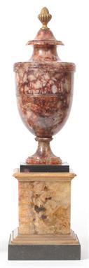
A Derbyshire Spar Classical Vase on Stand, early 19th century, the integral bell shape cover with ormolu fluted bud finial, the shoulder with triple reeded band and incised girdle string line, the vase of a general deep russet and white colour, on a short swept circular foot, on a veined spar and white and black marble mounted base, 41.2cm high overall See illustration, Underneath with cloth small label inscribed MAP 116 II.


An embroidered silk map of England and Wales, probably late 18th century, 54cm high, 44cm wide, unframed. The term `British Channel` was commonplace in the late 18th century, an example being in Thomas Jeffery`s A Chart of the British Channel published in 1787. Visit www.dnfa.com for condition reports.
-
109198 item(s)/page