We found 108737 price guide item(s) matching your search
There are 108737 lots that match your search criteria. Subscribe now to get instant access to the full price guide service.
Click here to subscribe- List
- Grid
-
108737 item(s)/page


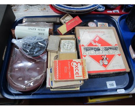
Lot 440
EMMANUEL BOWEN; a circa 1747 map of West Africa, 'A New & Accurate Negroland and the Adjacent Countries; also Upper Guinea...', 34 x 42cm, framed and glazed.Additional InformationOriginal margins but dirty and frayed to the edges, single vertical fold , muted colour and they have faded in parts.

Lot 102
Fiona Grady Rainbow (AP1), 2020 Watercolour ink on paper Signed verso 15 x 10cm (5¾ x 3¾ in.) Fiona Grady creates site-responsive drawings on walls, windows and floors using sequences of dispersing geometric shapes. Her practice recognizes the relationship between architecture, installation art and decoration; often using traditional mediums, such as fresco painting and stained glass, in a contemporary context. She plays with light, surface and scale; each piece changes with the light of day emphasizing the passing of time and the ephemeral nature of the work. The artworks are imaginings of how light moves throughout a space, stretching and rotating with the throughout the day. However she does not seek to literally map light but instead create rhythms; the blocks of colour act as a vessel that pinpoints the viewers' presence within their setting and allows them to contemplate their surroundings. The artworks for Art on a Postcard auction were created during the coronavirus outbreak in her self-isolation kitchen studio. They are inspired by the rainbows created by children for the windows of their homes. The rainbows are a symbol of hope, a thank to our carers and frontline staff.

Lot 103
Fiona Grady Rainbow (AP2). 2020 Watercolour ink on paper Signed verso 15 x 10cm (5¾ x 3¾ in.) Fiona Grady creates site-responsive drawings on walls, windows and floors using sequences of dispersing geometric shapes. Her practice recognizes the relationship between architecture, installation art and decoration; often using traditional mediums, such as fresco painting and stained glass, in a contemporary context. She plays with light, surface and scale; each piece changes with the light of day emphasizing the passing of time and the ephemeral nature of the work. The artworks are imaginings of how light moves throughout a space, stretching and rotating with the throughout the day. However she does not seek to literally map light but instead create rhythms; the blocks of colour act as a vessel that pinpoints the viewers' presence within their setting and allows them to contemplate their surroundings. The artworks for Art on a Postcard auction were created during the coronavirus outbreak in her self-isolation kitchen studio. They are inspired by the rainbows created by children for the windows of their homes. The rainbows are a symbol of hope, a thank to our carers and frontline staff.

Lot 104
Fiona Grady Rainbow (AP3), 2020 Watercolour ink on paper Signed verso 15 x 10cm (5¾ x 3¾ in.) Fiona Grady creates site-responsive drawings on walls, windows and floors using sequences of dispersing geometric shapes. Her practice recognizes the relationship between architecture, installation art and decoration; often using traditional mediums, such as fresco painting and stained glass, in a contemporary context. She plays with light, surface and scale; each piece changes with the light of day emphasizing the passing of time and the ephemeral nature of the work. The artworks are imaginings of how light moves throughout a space, stretching and rotating with the throughout the day. However she does not seek to literally map light but instead create rhythms; the blocks of colour act as a vessel that pinpoints the viewers' presence within their setting and allows them to contemplate their surroundings. The artworks for Art on a Postcard auction were created during the coronavirus outbreak in her self-isolation kitchen studio. They are inspired by the rainbows created by children for the windows of their homes. The rainbows are a symbol of hope, a thank to our carers and frontline staff.

Lot 105
Fiona Grady Rainbow (AP4), 2020 Watercolour ink on paper Signed verso 15 x 10cm (5¾ x 3¾ in.) Fiona Grady creates site-responsive drawings on walls, windows and floors using sequences of dispersing geometric shapes. Her practice recognizes the relationship between architecture, installation art and decoration; often using traditional mediums, such as fresco painting and stained glass, in a contemporary context. She plays with light, surface and scale; each piece changes with the light of day emphasizing the passing of time and the ephemeral nature of the work. The artworks are imaginings of how light moves throughout a space, stretching and rotating with the throughout the day. However she does not seek to literally map light but instead create rhythms; the blocks of colour act as a vessel that pinpoints the viewers' presence within their setting and allows them to contemplate their surroundings. The artworks for Art on a Postcard auction were created during the coronavirus outbreak in her self-isolation kitchen studio. They are inspired by the rainbows created by children for the windows of their homes. The rainbows are a symbol of hope, a thank to our carers and frontline staff.
Lot 151
Kathryn Macnaughton Bundle of Love, 2020 Acrylic and pencil on paper Signed verso 15 x 10cm (5¾ x 3¾ in.) Canadian artist Kathryn Macnaughton deftly interweaves figurative painting with a combination of abstract expressionism, geometric abstraction, and even conventions of the painted still-life into one poetic statement. Here, these forms of figuration and still life have been flattened, like their more abstract counterparts, to face the frontal plane of the canvas. In this sense, the canvas - and the analog process of the painter's hand - references the computer screen and the digital touch, where these pieces originally begin to take their shape. She states: I wanted my digital work to look raw and handmade. Now that I create "physical" paintings, I want to give the illusion that the work is digital. Macnaughton, who trained and worked as a graphic designer, uses this sort of 'digital compression' to her advantage, and one begins to use typically post-analog language when discussing her work: masking, layering, colour-blocking, silhouette. Here these concepts are paired with more Romantic expressive movements: a scribble dances across a bust, outlined in silhouette, which guides the viewer's eye around the flattened curves as one guides the finger across a map. The work simultaneously houses a sensuality one aligns with gender tropes: as suggestions of feminine curves play shadow-tricks, appearing as vessels or curtains that guide the eye, but also obscure and reveal the picture plane while painterly splatters ad curves leap behind and before the picture plane. But also the masculine, referencing brutalist and Modernist architecture: the austerity and monolithic qualities of shape, form, and line, or perhaps even the sharp angles of cacti in the desert. We see references from Robert Morris to Georgia O'Keefe; Diebenkorn to DiChirico, and even a cheeky reference to the highly stylized drawings of Patrick Nagel (more colloquially known as the artist who made Playboy 'drawings' iconic of the entire 1980s). The work therefore works in polarities: analog and post-analog mark-making (ie: the painterly and the digital); feminine and masculine; pragmatism and Romanticism; expressiveness and obfuscation; light and dark. There is a sense of theatricality to her revelations, and it is, in every sense, a cheeky play of light and dark versus form and technique, like boxing with one's own shadow - an art of individual, delicate mastery.

Lot 193
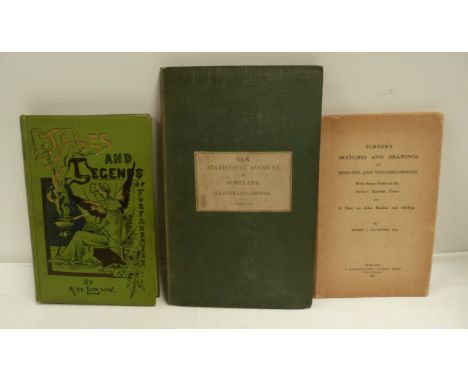
LOWSON ALEXANDER. Tales, Legends & Traditions of Forfarshire. First Series. Frontis & illus. Orig. pict. green cloth. Forfar, 1891; also New Statistical Account of Scotland, Clackmannshire, double page hand col. eng. map, orig. cloth, 1842 & Turner's Sketches & Drawings of Stirling & Neighbourhood, 1936. (3).


Lot 208
POPE ALEXANDER (Trans). The Iliad of Homer. 2 vols. Vol. 1 with eng. frontis & fldg. map, vol. 2 with fldg. eng. frontis & fldg. eng. plate. 12mo. Calf, rebacked. A. Manson, R. Williams & Others, n.d. but inscribed to front paste-down "1780 £0.5.9"; also the uniform 2 vol. set of Pope's Odyssey of Homer. (4).


Lot 301
WILSON ROBERT THOMAS. History of the British Expedition to Egypt to which is subjoined a Sketch of the Present State of That Country & Its Means of Defence. Port. frontis in facsimile. 3 fldg. eng. maps (some repairs noted to one of these) & 2 fldg. tables. Quarto. Rebound half calf, reps. to half title & title, damp stng. to early & concluding leaves. 1802; also the 12mo ed. of the same, frontis, map in facsimile, rebound qtr. calf, n.d. (2).


Lot 311
PICTON G. W. The Battle of Waterloo or a General History of the Events. Eng. title borders. Fldg. hand coloured eng. map of the Netherlands, 2 fldg. eng. battle plans with hand colouring, 6 hand coloured aquatint plates & 3 eng. port. plates. Rebound half calf, much internal browning & foxing. 2nd ed., n.d. but c.1816.


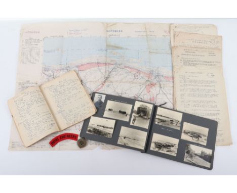
Lot 109
Highly Important and Extremely Comprehensive D-Day Archive of Ephemera and Photographs to Lieutenant Stephen C. Malenoir -Vickers (MC, MID.), Lieut Malenoir-Vickers was an Engineer Officer responsible for clearing mines and paths across Juno Beach at Courcelles, with his Armoured bulldozers, and he landed on D-Day. The Collection includes Restricted "Defence Overprint" maps of the Beach area, his Diary for 1944, "War Diary" from June 44 to May 45, Personal Photograph Album with original D-Day photographs and others through France and Belgium etc. We consider it almost unique to find Maps, a Diary, Photographs, War Diary, documents and contemporary letter, all for the same Officer for one of the most important wartime events in the 20th Century, namely D-Day. The first of the Defence maps is of Creully 1:25,000 Top Secret and dated May 1944 and shows the Beaches at Ver-Sur-Mer (Juno Beach), the second is an exceptionally rare 1:12,500 scale map of Bernieres-Sur- Mer, dated May 1944, Top Secret, because of the scale, great detail of all the beach defences are included with a key on the reverse. Two other "Defence" maps of Le Havre 1:10,000 dated 5 September 1944, show all the Defensive positions and were produced to assist a major attack on the Port, they too are very rare. The "Diary 1944 February 1st 1944 - March 31st 1945" Has some detailed entries and for the 6th June "Arrive & anchor 2/3 miles off French coast.. Hundreds of craft to unload.... See paratroops land... Haphazard AA Fire.. One of our planes down...to bed 0110 hrs" etc. etc. Extensive entries continue through Normandy campaign and beyond. War diary gives daily strength, casualties, work undertaken and comments etc., 7pp., through to mid May 1945. The Photograph album shows training in UK, Beach landings in Normandy, Pont L'Eveque, Siene, German Wreckage and head and shoulders photograph of Lieut. Malenoir-Vickers etc. etc. c.70 photographs in all. Note other loose original photographs of Bridge Building etc . Of particular interest is a full page handwritten letter Dated June 17th 1944 to his parents describing D-Day, being served Waffles and Syrup by "Negroes" in the wardroom on an American ship and later "the first night I slept in a slit trench" etc. Other documents too. including Top Secret Bigot Intelligence Summary for Neptune area (copy no 15) and Top Secret "Distinctive markings for Aircraft" with drawings, dated 25th April, note book, badges etc,. In all an exciting find for which viewing is thoroughly recommended.
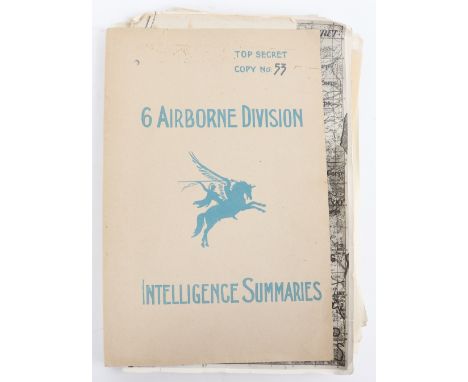
Lot 113
Important Top Secret File "6 Airborne Division Intelligence Summaries" Numbered Copy, Operation Varsity Intelligence Summaries March 1945, include considerable detail of German troop dispositions, particularly of German Parachute units, some of which had been obtained from prisoners. In addition the file contains Top Secret maps showing the Rhine and flood risks, another large Top Secret photographic map, dated 14 March 45, showing all the German units From First Para in the North, down through the Koln sector to Fifth Panzer Army to Remagen. Considerable detail. c.60pp., including maps,

Lot 118
Souvenirs of the Iraq War, interesting items brought back by a soldier from the Iraqi campaign. Liberated Military map with plastic overlay marked with positions and units, Red, white, green military pennant, folded colour poster of Saddam with Arabic description (folded) and two original colour photographs of an Iraqi military briefing and Officers inspecting a tracked vehicle etc (7 items)
Lot 119
Signed Napoleonic Map, being a important original nicely presented Plan of Pizzighettone & Gerra (Lombardy) believed produced as part of Napoleon's conquest of Italy 1796 43" x30" attractively coloured and Signed by Louis-Alexandre Berthier, Napoleon's Chief of Staff and stamped "de l'arm d'Italie" Modest wear and short split on folds. Together with original map from same period of Fortress of Ceva (Piedmont) 21" x 15" Some browning and tears to edges, (2 items)
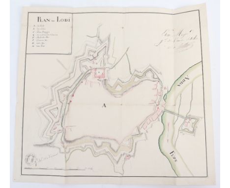
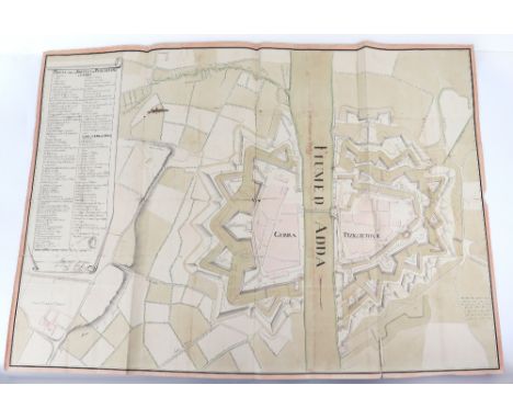
Lot 120
Signed Napoleonic Map, important original Plan of Lodi showing the defences in watercolour 17" x 16" to support Napoleon's conquest of Italy 1796, Signed by Louis-Alexandre Berthier, Napoleon's Chief of Staff also stamp of "de l'arm d;Italie" together with interesting large linen map from same period Plan of Milan Castle 30" x 21" dissected and lain on linen, marked with army positions and projected lines of attack (2 items)

Lot 121
Signed Napoleonic Map, excellent hand drawn coloured map of Sabionita (Lombardy) 26" x 23" produced as part of Napoleon's conquest of Italy 1796 and signed by his Chief of Staff Louis-Alexandre Berthier and stamped "de l'arm d'Italie" together with similar coloured map, unsigned, of Fort Fuentes (near Colico, Northern Italy) 30" x 17" with probable contemporary stamp. Two very interesting contemporary maps (2 items)


Lot 127
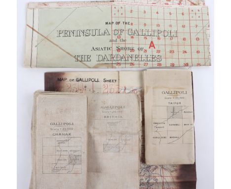
Important Collection of Original Gallipoli Maps, includes Gallipoli Sheet 1, 1:40,000 showing the Straits, the Forts, and Cape Helles together with a number of key locations c.80cms x 65cms, linen with some ink staining, (features and names still clear), Gallipoli Chanak, 1:20,000 dated 1915, shows Krithia and Chanak Kale and much detail, linen, Gallipoli, Taifur, 1:20,000, north section of Peninsular dated 1915, paper map, Excellent map of Gallipoli Krithia, 1:20,000 1915, shows Lancashire Landing, Gully Beach & Helles, c.75cms x 40 cms, linen, also Official map "Map of Peninsular of Gallipoli and Asiatic Shore of the Dardanelles" 1:63,000, showing whole Peninsular in colour dated War Office 1908, (updated as some point) stamped cancelled with map of Palestine 1918 on reverse. Slight loss at one fold (area of sea and section South of Straits), linen. Unusually good grouping of 5 original Gallipoli maps,
Lot 129
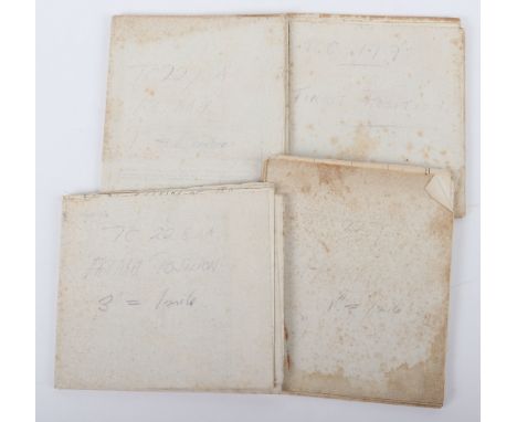
WWI Trench Linen Maps of Mesopotamia, Fat-hah, (GHQ) 3 inch to 1 mile with a large number of numbered Trenches shown both sides of the Tigris just below Fat-Hah, very detailed and in good condition. The second and third Trench maps show a similar area with a different scale of 1 inch to 1 mile, one dated 15-10-18 & the other 11-5-18. The fourth Trench map is of Tikrit (TC 199), 3 inches to 1 mile, very detailed showing trenches, artillery and MG's West of Tikrit on the Tigris, with pencil annotations. All very good condition (4)


Lot 178
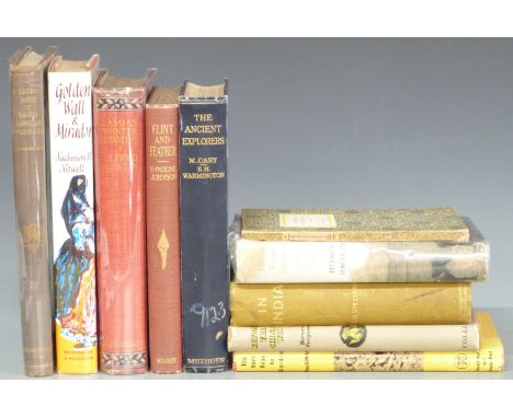
Alfred Austin Lamia’s Winter-Quarters with colour plates 1907 first edition decorated cloth, Sacheverell Sitwell Golden Wall and Mirador 1961, G.W. Steevens In India with map 1909, A Second Book of South African Flowers 1936, The Ancient Explorers with maps 1929, Hard Road to Klondike 1962 etc (10)

![[Shropshire] Printed Maps of Shropshire AD 1577-1900 by Geoffrey Cowling, Robert Baugh’s Map of Shopshire 1808 with introduct](https://cdn.globalauctionplatform.com/1293449b-58d3-49c6-ba4e-ab6d0118aecb/2ddf992b-336d-4b04-8250-ab84011cc743/468x382.jpg)
Lot 216
[Shropshire] Printed Maps of Shropshire AD 1577-1900 by Geoffrey Cowling, Robert Baugh’s Map of Shopshire 1808 with introduction by Barrie Tinder the individual parts housed in slipcase, Shropshire Arms & Lineages by The Rev. Kittermaster 1869, Wenlock in The Middle Ages, All Round The Wrekin by Walter White 1860, A History of Tong Shropshire with Notes on Boscobel by George Griffiths Illustrated 1894 and a copy of Boscobel & Its Visitors 1910 (7)
![[William Morris & Merton Abbey] Rural Rides by William Cobbett published Reeves & Turner 1885 in 2 volumes with a fro](https://cdn.globalauctionplatform.com/1293449b-58d3-49c6-ba4e-ab6d0118aecb/e237fa2e-6e1e-412d-84dc-ab84011cddab/468x382.jpg)
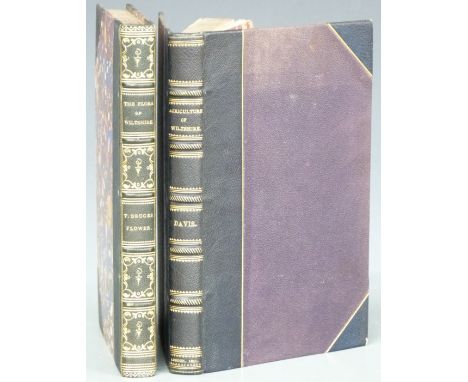
Lot 234
General View of the Agriculture of Wiltshire Drawn up and Published by Order of The Board of Agriculture by Thomas Davis 1811 first edition with portrait and a folding hand-coloured map bound in half leather with raised bands and gilt titles and decoration, The Flora of Wiltshire comprising the Flowering Plants and Ferns indigenous to the County by Thomas Bruges Flower (Parts 1-9) with several parts signed by author, bound in half leather with raised bands, gilt title and decorated spine (2)
![[Arabia] The Modern Traveller A Description Geographical, Historical and Topographical of the Various Countries of The Globe](https://cdn.globalauctionplatform.com/1293449b-58d3-49c6-ba4e-ab6d0118aecb/5293d4ea-f6c8-4077-b6f4-ab84011cf30c/468x382.jpg)
Lot 242
[Arabia] The Modern Traveller A Description Geographical, Historical and Topographical of the Various Countries of The Globe by Joshua Conder this being Volume the Fourth in the series on Arabia, published by James Duncan 1830 with folding map and plates, bound in half leather with gilt title labels & blind stamped decorated panels on spine, housed in slipcase, offered with an English-Arabic & Arabic-English Dictionary in cloth boards with gilt leather spine (2)

Lot 256
A New Map of The River Thames from Thames Head to London from entirely New Surveys made personally by the Author and corrected to the present time combined with guides giving every information required by The Tourist, The Oarsman and The Angler by Henry W. Taunt (c1880) Sixth Edition with folding maps and original photographs tipped-in bound in full leather with gilt illustrations and titling, Alfred Williams Round About The Upper Thames 1922 and Folk Songs of The Upper Thames 1923 (3)
Lot 257
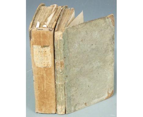
General View of the Agriculture of the County of Devon with Observations on the Means of its Improvement drawn up for the consideration of The Board of Agriculture and Internal Improvement by Charles Vancouver, printed for Richard Philips 1808 first edition with folding hand-coloured map, tables and 28 engraved plates (some folding and hand-coloured), bound in boards with paper covered spine & printed label (binding worn) and Discourses Explanatory of the Object And Plan of the Course of Lectures on Agriculture and Rural Economy by Andrew Coventry 1808 in boards (2)
![[Exploration] Fighting The Polar Ice by Anthony Fiala illustrated from photographs by the author also eight from paintings, i](https://cdn.globalauctionplatform.com/1293449b-58d3-49c6-ba4e-ab6d0118aecb/6569fc17-928f-4e29-9f37-ab84011d0e14/468x382.jpg)
Lot 258
[Exploration] Fighting The Polar Ice by Anthony Fiala illustrated from photographs by the author also eight from paintings, in colour, published Hodder & Stoughton 1907 first English edition with folding map at rear in gilt cloth, Discovery of The North Pole by Dr. Frederick A Cook and Commander Robert E. Peary illustrated 1909 and Finding The North Pole illustrated 1909 publishers cloth (3)
Lot 260
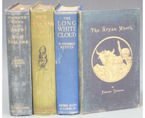
Pioneer Work in the Alps of New Zealand A Record of the First Exploration by Arthur P. Harper with Maps & Illustrations 1896, first edition in publisher's cloth, The Long White Cloud (Ao Tea Roa) by The Hon. William Pember Reeves Illustrated 1924, The Aryan Maori by Edward Tregear 1885 inscribed by author to Earl of Pembroke and New Zealand by Max Herz with 81 illustrations and map, publisher's cloth (4)
![[New Zealand] Ko Nga Mahinga A Nga Tupuna Maori He Mea Kohikohi Mai Na Sir George Grey Govenor in chief of The New Zealand Is](https://cdn.globalauctionplatform.com/1293449b-58d3-49c6-ba4e-ab6d0118aecb/e2432874-79be-477e-8db4-ab84011d1a67/468x382.jpg)
Lot 266
[New Zealand] Ko Nga Mahinga A Nga Tupuna Maori He Mea Kohikohi Mai Na Sir George Grey Govenor in chief of The New Zealand Islands, 1854 first edition, The Maori King by J.E. Gorst 1864 with folding map & portrait bound in leather, A Dictionary of the New Zealand Language by William Williams 1852 and An Old New Zealander, or Te Rauparaha by T. Lindsay Buick 1911 in gilt cloth (4)
![[Canals & Waterways Birmingham] Georgiii III Regis Anno Tricesimo Septimo, various Canal Acts for Dudley 1776, 1785, 1790](https://cdn.globalauctionplatform.com/1293449b-58d3-49c6-ba4e-ab6d0118aecb/c82d7806-cfae-4350-b8a5-ab84011d33a0/468x382.jpg)
Lot 283
[Canals & Waterways Birmingham] Georgiii III Regis Anno Tricesimo Septimo, various Canal Acts for Dudley 1776, 1785, 1790, 1793, Act for 1767 a Canal from Hawford to Claines, Droitwich Canal Junction 1852, Acts for Stourbridge Extension 1837, Act 1858 for the Birmingham Canal to Raise Money, Act of 1854 to make New Canals in Birmingham, Act of 1846 London & Birmingham Arrangement, Act 1844 for borrowing money etc etc. the Acts bound into 4 volumes, The Late Francis Duke of Bridgewater A Collection of the Several Acts relating to The Canals in boards (worn) with a Folding Map of Canals and Navigable Rivers in England & Wales Engraved for Potts' New Gazetteer

Lot 305
The Hobbit or There and Back Again by J.R.R. Tolkien Illustrated by the Author, published George Allen & Unwin 1955 7th impression with colour frontispiece and several black & white illustrations bound in publisher's decorated cloth with map endpapers and in original colour illustrated (split) dust-wrapper
Lot 323
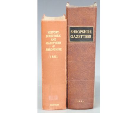
The Shropshire Gazetteer, with an Appendix Including A Survey of The County and Valuable Miscellaneous Information, with plates printed & published by T. Gregory 1824 first edition with various engravings and a folding map by John Cary, bound in recent half-leather with History, Gazetteer and Directory of Shropshire by Samuel Bagshaw 1851 rebound and lacking map (2)
-
108737 item(s)/page