We found 109182 price guide item(s) matching your search
There are 109182 lots that match your search criteria. Subscribe now to get instant access to the full price guide service.
Click here to subscribe- List
- Grid
-
109182 item(s)/page


Lot 37
Ascension. 1750 (approx.) "Map" of Ascension, an illustration from a book printed in black and hand-coloured. Entitled 'ILE D'ASCENSION', showing the island (with some rather peculiar mountains) surrounded by ships, three in the foreground engaged in battle; eleven oversized seabirds appear between the battle scene and the island. The whole 5½ x 8", the illustration 4 x 5¾"; an attractive frontispiece for a collection

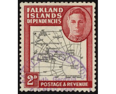
Lot 4
Various countries KG VI, used collections as removed from the SG printed album with extras. GB and Channel Islands; Bahrain; Canada; Cook Islands (no Arms); Falkland Dependencies complete plus 6d ochre and Thin Map set; Gilbert & Ellice with some shades, also Dues set; Newfoundland good range; Nauru Ships set; New Guinea £2; some Niue; Papua and Pitcairn complete; St Helena with extra shades; Tonga complete; Transjordan 1943 set with extra £1 (plus 1930 500m); Tristan 1952 set


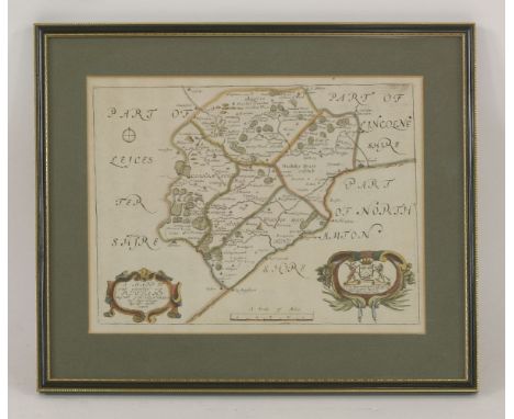
![John Speed,'Essex, Devided [sic] into Hundreds',a hand coloured engraved map, mounted and double glazed,38.5 x 51cm](https://cdn.globalauctionplatform.com/31685e75-f2a0-4e64-b851-a45800f0b835/1db59d0f-efc4-41d0-d62d-97f288367c5e/468x382.jpg)

Lot 187
TRAVEL, NAVIGATION, ETC:1. Ross, John: Narrative of a Second Voyage in Search of a North-West Passage. L, Webster, 1835, 1st edn, 4to., complete including all maps, charts and plates including three coloured. Half leather. CONDITION: Worn & scuffed; occasional foxing; the large chart & pp 243/246 loose;2. White, W: History, Gazetteer and Directory of Suffolk. Sheffield, 1844, 1st edn. CONDITION: lacking the map and few pages taped on;3. Walton, I: The Complete Angler. Major, 1824, 2nd. edn half leather. CONDITION: worn;4. Hogarth, W: Complete works. London printing and publishing, no date, c.1880; folio, full leather. CONDITION: aeg. covers worn; o/w G;5. Dore, G (ill): Thomas Hood. E. Moxon, 1870. Folio, full leather gilt, aeg. CONDITION: Covers scuffed; o/w G+;6. Plus four other works (9)


Lot 23
WALPOOLE, George Augustus:The New British Traveller or, A Complete Modern Universal Display of Great Britain and Ireland. L, Alex Hogg, nd, (Frontis dated 1794). Revises, corrects and Improved by W.H.Dalton. Folio, with many full page plates. CONDITION: Lacking the map and some plates; covers worn and detached. Sold as a collection of plates, with all faults

Lot 28
TRAVEL and TOPOGRAPHY:1. Hunter, J: Hallamshire. The History and Topography of the Parish of SHEFFIELD. L, Virtue, nd, C1880, new edn. with subscribers' list. Half leather. CONDITION: foxing to plates; o/w VG;2. Petrie: A History of Egypt, in six volumes. L, Methuen, 1894. Fully illustrated. Original cloth, gilt. CONDITION: VG;3. Kane, E.K: Arctic Explorations. The Second Grinnell Expedition. 2 Vols. L, Nelson, 1868. With folding map and plates; original cloth, gilt. CONDITION: Little worn; o/w G;4. Life and Explorations of David Livingstone. L, Murdoch, nd. c.1875; with coloured and tinted plates. Full leather, gilt. CONDITION: Little worn; o/w G;5. Wyatt, H: Jersey in Jail 1940-45. Aris, 1985, numbered limited edn. 556/750. Illustrated by Edmund Blampied. Original cloth, gilt. CONDITION: VG+/Fine;6. Plus two others (13)

Lot 299
ILLUSTRATED:1. O'Connor, John: A View of Kilvert. Passages from the Diary of the Rev. Francis Kilvert selected and illustrated in colour by John O'Connor and introduced by John Ryder. Glasgow, Foulis Press Archive, 1979, 1st. edn., dw; limited edn. of 50 copies only, this being no. 24 and signed by O'connor, folio. CONDITION: Fine;2. O'Connor, John: Canals, Barges And People. L, Art And Technics, 1950, 1st. edn. dw. Inscribed and signed by O'connor, dated 1950. CONDITION: Small cuts to dw. With sketch map and 24 superb colour illustrations. CONDITION: Foxing; o/w VG;3. The Wood-Engravings of John O'Connor. With a commentary by Jeannie O'Connor. Andoversford, the Whittington Press, 1989. Limited edn. no. 8 of 350 copies; large 4to.; slipcase. CONDITION: Fine;4. People & Places: Wood-engravings by John O'Connor. Introduction by John Randle. Whittington Press, 1999, limited edn. no.87 of 375 copies. CONDITION: Fine;5. O'Connor, John (Illustrator): England : An Ant

Lot 304
TRAVEL AND TOPOGRAPHY:1. Great Yarmouth: A Narrative of the Grand Festival, at Yarmouth, on Tuesday, the 19th of April, 1814; with an Appendix. Yarmouth, J Keymer, 1814. Extra engraved title page plus two folding plates, 72pp. Original boards. CONDITION: Worn and chipped; o/w G;2. A New Guide to Cheltenham. nd, new edn. With folding map and views. Leather backed marbled boards. CONDITION: Foxing and offsetting; o/w G;3. Excursions in the County of Suffolk; Volume one only. L, Longman, 1818. With folding coloured map plus many plates. CONDITION: VG;4. Eden, P: Waterways of the Fens. 1972, 1st. CONDITION: VG (4)


Lot 41
SCIENCE, CHURCHILL, ETC:1. A New and Universal Dictionary Of Arts And Sciences. L, Printed for the Proprietors and sold by John Hinton, 1751, 1st. edn. Illustrated with many plates. Folio, full leather; front covers detached; the odd small stain;2. Churchill, Winston S: London to Ladysmith via Pretoria. L, Longmans, 1900, 1st. edn. with folding maps, etc. Original pictorial cloth with gilt lettering, little worn; frontis map little frayed; light foxing; o/w G;3. Blakeney, W: On the Coasts of Cathay and Cipango Forty Years Ago. A Record of Surveying Service in the China Yellow and Japan Seas and on the Seaboard of Korea and Manchuria. L, Elliott Stock, 1902, 1st. edn. with folding maps and plates. Original pictorial cloth, worn and with a cut to side; some of the folding maps torn and repaired (3)

Lot 45
WRIGHT'S DIRECTORY OF NOTTINGHAMSHIRE:1. 1862: No Map, rebound in cloth. CONDITION: Occasional foxing and browning; o/w G;2. 1885: Original cloth, gilt. No map. CONDITION: VG;3. 1897: Original cloth, rebacked with original spine. No map. CONDITION: VG;4. 1910: Original cloth, rebacked with original spine. Map in facsimile;5. 1902: Original cloth, rebacked with original spine. No map (5)

Lot 47
WHITE'S DIRECTORY OF NOTTINGHAMSHIRE:1. 1885-6: 2nd edn. Map pasted to inside of front cover. Half leather. CONDITION: Little scuffed; o/w VG;2. 1894: 3rd. edn. with a facsimile map. Half leather. CONDITION: Little scuffed; o/w VG;3. 1864: Lacking the map. Full leather, rebacked with new spine and epps (3)

Lot 48
MIDDLETON, Charles Theodore:A New and Complete System of Geography. In two volumes,c.1778. With a total of eighteen maps (including that of North America) out of 21 and 95 plates out of 99 (including many views). CONDITION: The two volumes are loose in two boxes without any binding and lacking title pages and some text, as well as 3 maps and 4 plates. The map of the Globe in two halves and a few plates and maps frayed at the edges with some loss. Sold as a collection of maps and plates, not subject to return (2)


-
109182 item(s)/page